Effects of Land Use Change Related to Small-Scale Irrigation Schemes in Kilombero Wetland, Tanzania
 Edmond Alavaisha
 Victor Mbande
 Lowe Börjeson
 Regina Lindborg
- 1Institute of Resource Assessment, University of Dar es Salaam, Dar es Salaam, Tanzania
- 2Department of Physical Geography, Stockholm University, Stockholm, Sweden
- 3Bolin Centre for Climate Research, Stockholm, Sweden
- 4Department of Human Geography, Stockholm University, Stockholm, Sweden
- 5Department of Social Studies, Mwalimu Nyerere Memorial Academy, Dar es Salaam, Tanzania
Increasing agricultural land use intensity is one of the major land use/land cover (LULC) changes in wetland ecosystems. LULC changes have major impacts on the environment, livelihoods and nature conservation. In this study, we evaluate the impacts of investments in small-scale irrigation schemes on LULC in relation to regional development in Kilombero Valley, Tanzania. We used Remote Sensing (RS) and Geographical Information System (GIS) techniques together with interviews with Key Informants (KI) and Focus Group Discussion (FGD) with different stakeholders to assess the historical development of irrigation schemes and LULC change at local and regional scales over 3 decades. Overall, LULC differed over time and with spatial scale. The main transformation along irrigation schemes was from grassland and bushland into cultivated land. A similar pattern was also found at the regional valley scale, but here transformations from forest were more common. The rate of expansion of cultivated land was also higher where investments in irrigation infrastructure were made than in the wider valley landscape. While discussing the effects of irrigation and intensification on LULC in the valley, the KI and FGD participants expressed that local investments in intensification and smallholder irrigation may reduce pressure on natural land cover such as forest being transformed into cultivation. Such a pattern of spatially concentrated intensification of land use may provide an opportunity for nature conservation in the valley and likewise contribute positively to increased production and improve livelihoods of smallholder farmers.
Introduction
Agriculture is today a major force that shapes land use globally. About 40% of the earth’s land surface is composed of pastures and croplands (Foley et al., 2005) and over half of the cultivated areas have been cleared during the last century (Houghton, 1994; Meyfroidt et al., 2013). Conversion of forest, grassland, and woodland into cropland and pasture has increased dramatically in the tropics (Houghton, 1994; Matson et al., 1997) as well as the conversion of tropical wetlands into agriculture (Verhoeven and Setter, 2010). This land conversion is currently a threat to soil fertility and water quality, but also to biodiversity. Although land use intensification is of global concern, it also has major local and regional effects. This is specifically true for the current increased demand and competition for farmland in fertile wetlands, especially in developing countries (Deininger and Byerlee, 2011; Hall et al., 2015; Scoones et al., 2018). In particular farming in wetlands influences availability and quality of water and soils, but also vegetations structure. This has resulted in considerable loss of wetland biodiversity associated with natural vegetation (Vrebos et al., 2015; Milton et al., 2018; Ramsar Convention on Wetlands, 2018).
In Tanzania, overexploitation leading to loss of soil fertility and erosion in highland areas (Johansson and Isgren, 2017; Colin, 2018), coupled with demographic growth and climate change effects (Kangalawe and Liwenga, 2005; Msofe et al., 2019), have increased the need to conserve the highland habitats and an increase in wetland agriculture and irrigation (Leemhuis et al., 2016; Colin, 2018). Due to economic opportunities and limitations of rainfed farming, irrigation has increased, to a large extent by means of farmer-led developments (Filipski et al., 2013; de Bont et al., 2019). To reduce potential impacts at local scale, empowerment of smallholder farming systems is a potential option to increase production in restricted small areas while reducing land transformation at a larger landscape. To make informed local and national decisions on sustainable land use, several studies have recently assessed LULC changes in wetlands with different techniques: 1. Using communities’ perceptions (Johansson and Isgren, 2017; Seki et al., 2018; Johansson and Abdi, 2020). 2. Remote sensing (RS) and Geographical Information System (GIS) (Kashaigili and Majaliwa, 2010; Leemhuis et al., 2017; Msofe et al., 2019; Munishi and Jewitt, 2019; Thonfeld et al., 2020).
Effects of farming practices play out differently depending on the scale (Jingan et al., 2005). Intensified land use at a regional scale may result in a simplified agroecosystem (low biodiversity), with large monocultural crop fields and low heterogeneity (Landis, 2017; Grab et al., 2018). Subsequently, many of the ecological interactions and ecosystem processes will be disrupted, leading to lowered generation of ecosystem services (Vandermeer et al., 1998; Chapin et al., 2000; Douglas, 2018). Alternatively, improved farming technology at a small scale can reduce pressure for large scale conversion into farming (Rosset, 2000; Jingan et al., 2005; Fischer et al., 2014; Fraanje, 2018) and could be positive for preserving remaining natural habitats. Loss and degradation of habitats like forests and wetlands may lead to a severe decline in species at the regional scale. For example, transformation of large wetland areas is suggested to be the main cause behind the decline of the endemic Poku antelope (Jenkins et al., 2002; Bonnington et al., 2007) and loss of bird species and small mammals in Tanzanian wetlands (Birdlife International 2016). Moreover, increasing competition for grazing areas between livestock and wildlife is currently a major threat to the survival of wild animal populations (Bonnington et al., 2007; O’Keeffe et al., 2017).
The floodplain of the Kilombero Valley wetland has been an important area for rice production since at least the 1800s (Monson, 2000) and was already recognized as an area of high agricultural potential in 1909 when the Germans surveyed for a possible railway route through the valley (Beck, 1964). The aim of this study was to examine LULC changes resulting from governmental initiatives to expand smallholder irrigation farming in the Kilombero Valley. To get a comprehensive understanding, we used RS and GIS techniques, together with interviews with local informants. The study addressed the following key questions: 1) What effects have the small-scale irrigation schemes had on the local LULC compared to the LULC changes at the regional valley scale during the last 26 years? and 2) How are these changes perceived by the stakeholders in the valley in relation to historical context, productivity of smallholder farming and preserving biodiversity?
Materials and Methods
Study Area
Kilombero Valley is one of the sub-basins of Rufiji located between 34°33′E—37°20′E and 7°39′S—10°01′S in southern central Tanzania. The climate in the valley is subtropical humid and the rainfall is bimodal with an annual average between 1,200 and 1,400 mm. The long-rain season is between March–May and the short-rain season is between November–January. The mean daily temperature is between 22 and 23°C (Koutsouris et al., 2016), with considerably cooler temperatures in the mountains and forested areas. The valley is complex in terms of hydrology as it is fed by many tributaries originating from the mountain moving downstream (Senkondo et al., 2018; Alavaisha et al., 2019a). Natural periodic flooding influences the shape and the size of the wetland and the yearly discharge varies between 92 and 3,044 m3/s (recorded at the Swero gauging station situated at the outlet of the catchment). (Leemhuis et al., 2017). To a great extent, flooding controls LULC soil fertility, discharge and volume of water in the valley (RAMSAR, 2002; Leemhuis et al., 2016). The wetland is characterized by grassland, bushland and cultivated land. Forest cover is common in the highlands and along streams close to the canal intakes, rivers and flood plain. Only small pockets of forests near the base of the Udzungwa mountains get flooded yearly. Agricultural activities are mainly located in the floodplains and major crops are rice, sugarcane and maize, but also cocoa, banana, cassava, and vegetables are grown. Unlike other crops, small gardens of vegetables are grown near tributaries and rivers to facilitate irrigation. The farming practices are either rainfed or based on irrigation, including both small, medium, and large-scale farms (Amuri, 2015; Alavaisha et al., 2019b).
This study was conducted using three different villages, each with a small-scale irrigation scheme, within the Kilombero Valley wetland (Figure 1): Msolwa Ujamaa irrigation scheme (in Msolwa Ujamaa village), Mkula irrigation scheme (in Mkula village) and Njage irrigation Scheme (in Njage village). The three schemes were selected because of their differences in their location in the valley, and development of agriculture practices and their relationship with irrigation development in the area since 1970s (Figure 2). We define the schemes as small-scale to differentiate them from the much larger irrigation operations represented by Kilombero Plantation Limited (KPL) and Kilombero Sugar Company Limited (KSCL). The small-scale irrigation schemes were selected to capture the temporal dynamics of land use changes at the local scale. They have similar system design starting in upstream areas, close to the forests, with water moving down through the primary canal to be distributed to fields through secondary and tertiary canals. The systems are managed by the villagers through an irrigation committee in cooperation with the district and Rufiji basin authority (Lal et al., 2016; Mosha et al., 2016). While Msolwa and Mkula are accessed easily from Ifakara town, in the Northeastern part of the valley, Njage is located further into the inner part of valley, close to Kilombero Plantation Limited (KPL), and less accessible from Ifakara. The access to the valley changed in the 20th century as Ujamaa villages were established and the TAZARA railway connected villages with markets (Figure 2). The railway, linking Morogoro, Dar es Salaam and Mbeya, is often the only reliable transport for crops during rainy seasons.
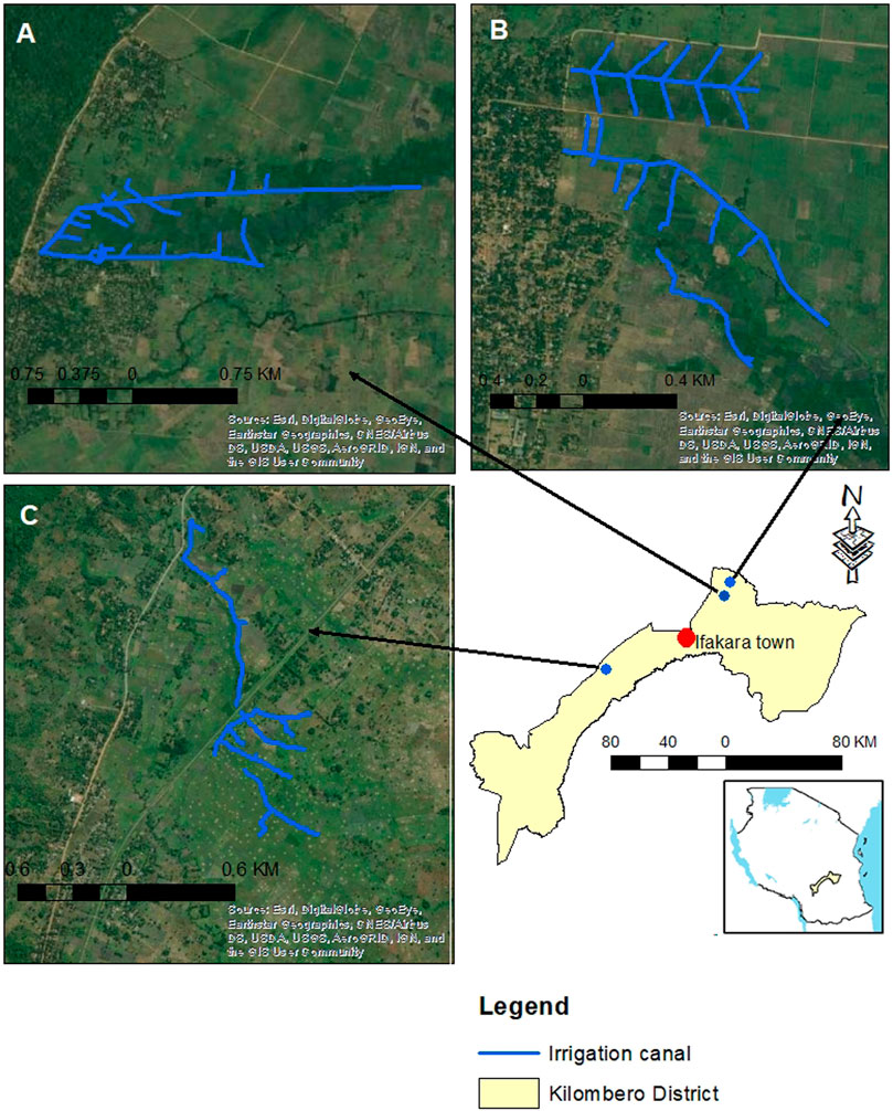
FIGURE 1. Map showing Kilombero wetland, Tanzania (within Kilombero District) and the three irrigation schemes included in the study: (A) Msolwa Ujamaa, (B) Mkula and (C) Njage village. (Source of basemap: Esri, DigitalGlobe, GeoEye, Earthstar Geographics, cNESAirbus. DS, USDA, USGS, AeroGRID, ICN, and the GIS User community).
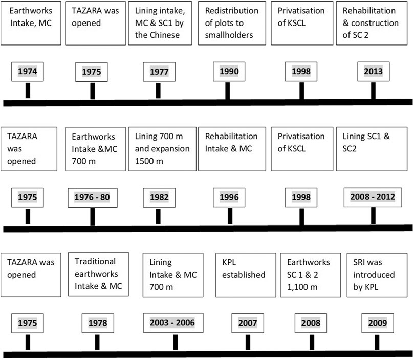
FIGURE 2. Development time-lines for irrigation schemes in Kilombero Valley, Tanzania compiled from Mbande et al. (unpublished) and compared with interview data. Upper panel is Msolwa Ujamaa irrigation scheme, middle panel is Mkula irrigation scheme and lower panel is Njage irrigation scheme. MC- Major canal, SC- secondary canal, TAZARA- Tanzania-Zambia Railway Authority, KSCL- Kilombero Sugar Company Limited, KPL- Kilombero Plantation Limited, SRI- System of Rice Intensification.
Data Collection and Analysis
The study involved gathering both quantitative and qualitative information to better understand and interpret land use changes from local to regional scale. Data were collected along the three irrigation schemes using two different methods: 1) Remote Sensing (RS) and Geographical Information System (GIS) techniques to map the LULC change. This mapping was then compared with already published information about land use change in the whole valley (Leemhuis et al., 2017) and 2) interviews with Key Informants (KI) and participatory Focus Group Discussion (FGD) with different stakeholders within the valley.
Classification and Description of Land use/Land Cover
First, we established a LULC classification system modified from three existing classification systems: FAO grouping (as in Di Gregorio and Jansen, 2000), Tanzania land planning commission (as in Msofe et al., 2019), and Kilombero Ramsar wetland classification (as in Munishi and Jewitt, 2019). In addition, field observations and general historical information gained from farmers during the preliminary field survey were used. Based on this information, we established five major LULC classes (Table 1).
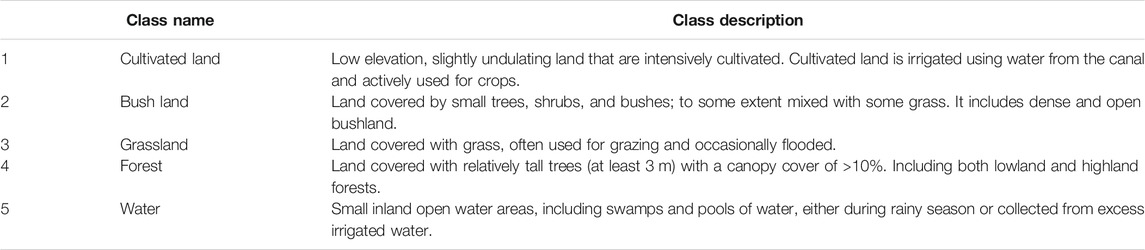
TABLE 1. Defined land cover/use classes surrounding irrigation schemes in Kilombero wetland, Tanzania.
Land use/Land Cover Change
LULC change in areas with small-scale irrigation schemes.
LULC data were collected through Google earth and satellite images. To understand the local scale effects of the canals and irrigation on land use change, we analysed the area close to the canals reflecting activities happening in the irrigation schemes. First, the three irrigation systems were mapped in Google Earth. A boundary that stretches out 100 m in each direction from the canal was marked as buffer for LULC change in each irrigation scheme. The position of the irrigation schemes and the surrounding buffers were checked through ground truthing during fieldwork in 2019.
To assess land LULC changes through time, we used satellite images taken during the dry season from three different dates: Landsat TM five for 1990, Landsat ETM+ for 2000, and Landsat OLI for 2017 (see Supplementary Table 1). An exception was made for Njage, where a cloud free Landsat OLI for 2016 was used. The images had a spatial resolution of 30 m. Images pre-processing and analysis were done using Arc GIS 10.3 software. We used the standard approach for data processing and analysis including image pre-processing for geometric and atmospheric corrections and projection, sub-setting, classification (unsupervised classification) using Iterative Self-Organising Data Analysis Technique (ISODATA) algorithm (Fuller et al., 1994; Huang and Jensen, 1997; Kashaigili et al., 2006; Duda and Canty, 2010). A majority filter was used to smoothen the classified output to show only the dominant classification (Fuller et al., 1994). Accuracy assessment was carried out using Idrisi (version 17.02) software. Specifically, the classified land cover for year 2017 was compared using projected land cover for year 2017. (c.f. Batisani and Yarnal, 2009; Foody, 2002; Schneider and Gil Pontius, 2001). We obtained a Kappa coefficient index of 0.81, 0.84. 0.82 for Msolwa Ujamaa, Mkula and Njage respectively, indicating an acceptable level of accuracy for all the maps. Normally, the Kappa coefficient index higher than 0.8 show the reliability of the simulation process (Viera and Garrett, 2005).
Land use/Land Cover Change at Regional Scale in Kilombero Valley
LULC change mapping of the whole Kilombero Valley was obtained from Leemhuis et al. (2017). The methods used by Leemhuis et al. (2017) were similar to the ones used in this paper. In short, they used 1) RS techniques and GIS to generate data on spatial and temporal changes in LULC. They used moderate resolution (30 m) Landsat images from the United States Geological Surveys (USGS) to analyse LULC change in ten-year intervals. LULC was quantified and involved atmospheric correction and cloud masking, projections, classification methodologies and accuracy assessment. Local experts were also used for data interpretation, thereby minimizing errors of misinterpretation. For our analysis, we chose to compare our LULC data with the 1994, 2004 and 2014 data from Leemhuis et al. (2017), as these periods were the best match to our own LULC data from the small-scale irrigation schemes.
Perception of Land use/Land Cover in the Irrigation Schemes
To get information about historical development, perceptions of informants on drivers of LULC change and conservation of nature, we used participatory methods, including FGDs and KI interviews, guided by checklist questions (Supplementary Appendix 1). The interviews involved men and women aged 40–60 years, and those with long experience regarding irrigation schemes, land use change and transformations. FGDs were mainly used to gather historical information on land use and land cover change through time as proposed by Adriansen (2012) and Kolar et al. (2015). In each irrigation scheme, two FGDs were performed, involving three different groups of stakeholders: irrigation committees, village leaders and old farmers. Each group was led by a moderator and contained nine participants of same gender to enhance discussion and reduce social barriers. Stakeholder groups with less than 10 participants are more easy to moderate and generate more open discussions (Canavor, 2006; Nyumba et al., 2018). The KI interviews were used to capture additional information on the local history of development irrigation schemes and perception on LULC change. We also discussed the perceptions of informants about the twin goals of improving productivity of smallholder farming and preserving biodiversity. Information from KI were integrated with those of FGDs to construct the time-lines presented above and table on the perception on LULC change during the development of irrigation schemes locally and regionally.
Results
Land use/Land Cover Change in the Irrigation Schemes
In general, there was an increase in cultivated land and a decrease in forest, bushland and grassland area in all irrigation schemes (Figure 3, Figure 4; Supplementary Table 2). The increase in cultivated area during the whole period, from 1990 to 2017, was more than 80% in Msolwa Ujamaa and Mkula and just above 50% in Njage (Figure 3; Supplementary Table 2). The changes, however, occurred at different stages in the villages. Msolwa Ujamaa and Mkula had their major increase in cultivated land from 1990 to 2000, whereas cultivated land in Njage increased most from 2000 to 2017 (Supplementary Table 2). For example, Msolwa Ujamaa had c. 7 ha cultivated land in 1990 and almost 70 ha in 2000, and Mkula had c. 9 ha in 1990 reaching to 90 ha in 2000. In Njage changes into cultivated land was only c. 20 ha during the same period.
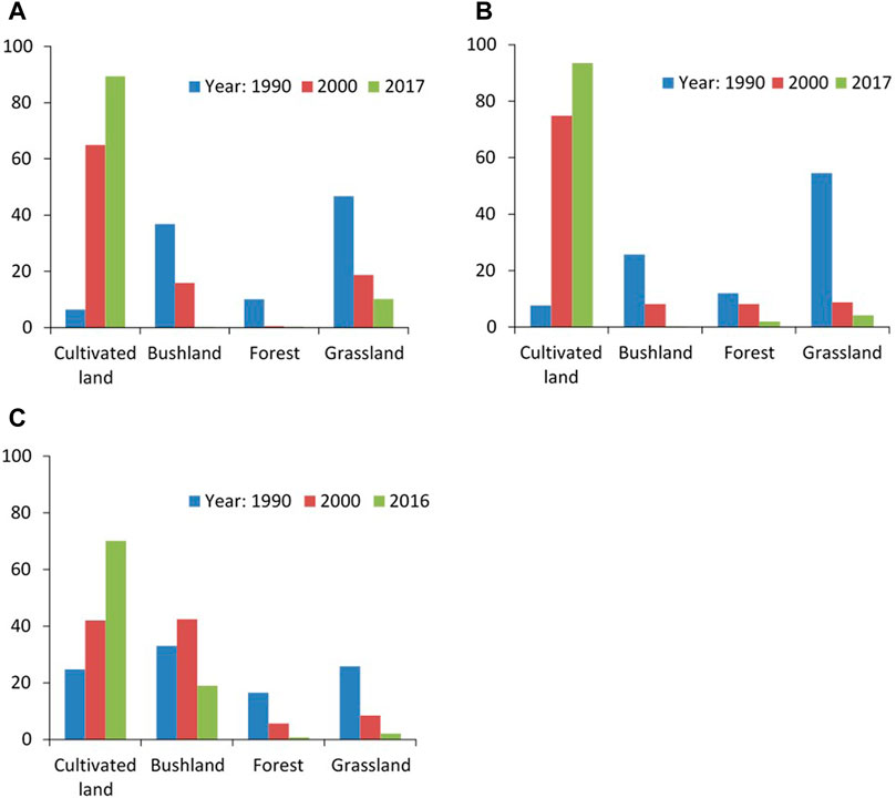
FIGURE 3. Annual rate of LULC change along irrigation canals: (A)- Msolwa Ujamaa canal, (B)- Mkula canal and (C)- Njage Canal.
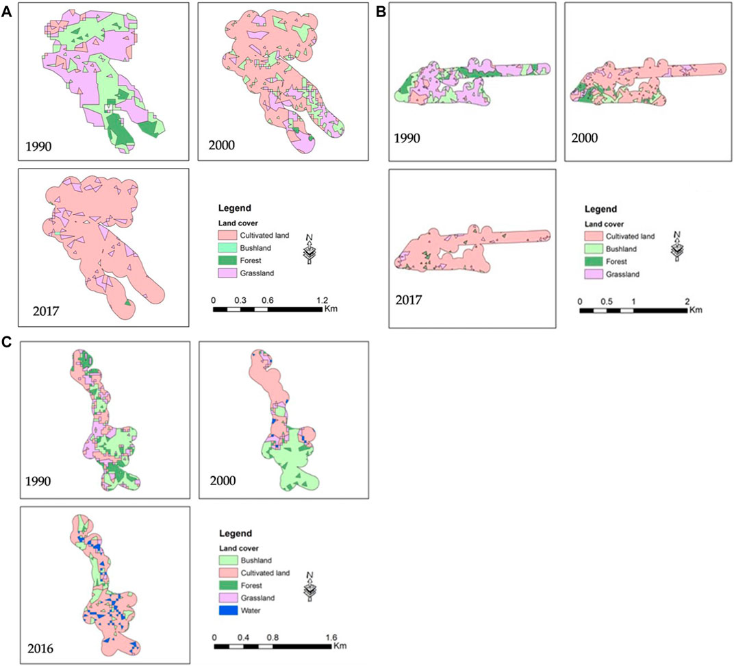
FIGURE 4. LULC change surrounding (A) Msolwa Ujamaa, (B) Mkula and (C) Njage irrigation scheme in Kilombero Valley, Tanzania from 1990 to 2016/17. The pools of water in year 2016 (C), reflect a temporary flooding event and wet conditions.
This trend is also seen in the rate of changes calculated for each year (Supplementary Table 2). In Msolwa Ujamaa, the annual change into cultivated land decreased from 5.9% between 1990 and 2000 to 1.4% between 2000 and 2017 (Figure 3). During the same period, grassland and bushland losses were 2.1 and 0.9% indicating that those land covers were cleared and transformed into cultivated land. Similarly, in Mkula village, with an annual increase of cultivated land of 6.7% (1990–2000) and 1.1% (2000–2017), whereas transformations in Njage were much more similar during the whole period, from 2000 to 1.7% 1990–2000 compared to 1.8% between 2000 and 2017 (Supplementary Table 2).
When analysing the change from one LULC to another in the three villages, we found some similarities and some differences (Table 2). The major change in Msolwa Ujamaa and Mkula was from grassland 35 and 51 ha, respectively, transformed into cultivated land from 1990–2000. There were also some transformations from bushland to cultivated land, but very little came from forest. The same transition trends were found between 2000 and 2017, although at much lower rates. In contrast, the major land use change in Njage occurred in the period 2000–2017 where almost a third of the total area 24% was transformed from bushland to cultivated land and a smaller part came from forest and grassland (Table 2). The same transition trend is detectable also between 1990 and 2000, but at smaller rate.
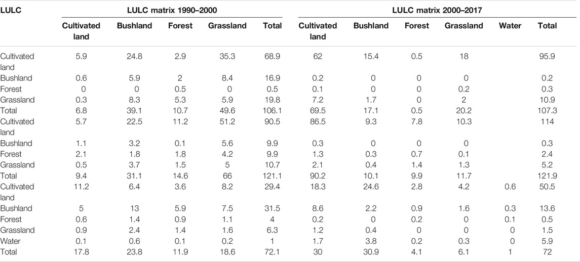
TABLE 2. LULC change transition matrix from 1990 to 2017 for (A) upper panel-Msolwa Ujamaa, (B) middle panel-Mkula, and (C) lower panel-Njage irrigation scheme in Kilombero Valley.
Land use/Land Cover Change at the Regional Scale Kilombero Valley
LULC changes for the whole Kilombero Valley have been documented earlier (Leemhuis et al., 2017). Although, the LULC classes are not matching perfectly with those in our analysis at the local scale, the results from this regional scale show that the valley has experienced major LULC change over the past 3 decades (Supplementary Table 3). Similar to the local small-scale irrigation schemes, the major changes have been from grassland and forest into cultivated land. The rate of change was not uniform during this period. From 1994 to 2004 about 0.2% of the land was annually converted into cultivated land, compared to 1.1% from 2004 to 2014. As a result, there was a loss of forest and grassland at an annual rate of 0.3 and 0.4%, respectively. Most of the changes occurred along the perimeter belt of the valley floor and the boundary of the flood plain, predominantly showing the expansion of agricultural areas at the expense of natural grassland and forest. In contrast to the changes in the small-scale irrigation schemes, urbanisation and bare land were other land cover types expanding in the catchment.
Perceptions on Drivers of Land use/Land Cover Change
Besides investments, such as construction of canals and intakes mentioned by informants, shown in Figure 2, there were a series of events during this period that were perceived as directly or indirectly associated with LULC change, both in the irrigation schemes and in the valley in general. Direct events mentioned in FGD were increased cultivation for the market, and the construction of railway and irrigation infrastructure (Table 3). FGD participants mentioned opening of the northern part of the valley to Morogoro and Dar es Salaam, to a large extent by an increased supply of rice. Prior to the construction of the TAZARA railway, the valley was according to the informants, mainly home to fishing communities who lived off the Kilombero River and also did a bit of farming. Some Maasai pastoralists arrived with their cattle in the 1980s. People from Iringa and Mbeya realised the valley’s potential for rice production and started settling in the 1990s. Further, increasing drought and shortage of land in highland areas caused migration of farmers to invest in parts of Msolwa and Mkula, near to Ifakara Town. The opening of the TAZARA railway in 1975 made many remote parts of the valley more accessible, leading to expansion of rainfed farming in the valley. One informant mentioned that “I came in 1977 to Sululu because one of my parents worked for TAZARA so the family also had to come here, and decided to stay and start cultivating different crops.” The respondents in FGD and KI interviews also mentioned the attractive climatic conditions, search for agricultural land, and how they had followed spouses and relatives as important factors for migration into the valley, particularly in Msolwa Ujamaa and Mkula. While the railway was not regarded as particularly influential to the land use changes within the irrigating canals, the resulting migration were mentioned to be more influential also for the expansion of cultivation in the small-scale irrigation schemes (Table 3).
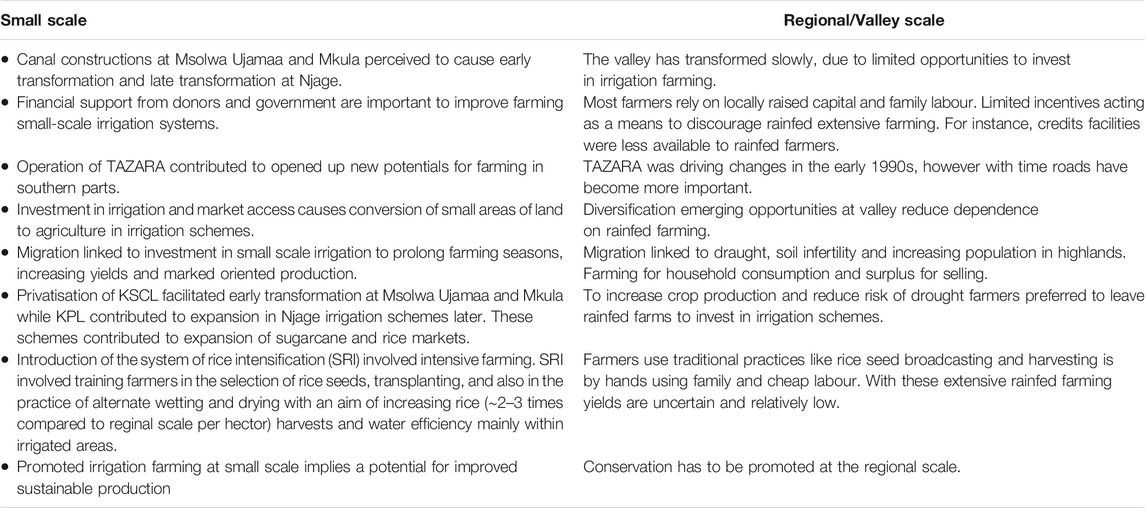
TABLE 3. Perceptions on drivers of LULC change between small scale and reginal scale in the Valley.
The end of socialism in the 1980s and the beginning of privatisation in the early 1990s was the starting point of new irrigation interventions (see Figure 2). Focus group discussants and key informants stated that the irrigation schemes were much improved from 1990 to 2000 (Table 3). All schemes had similar development patterns, except for the expansion of cultivated land, where discussants mentioned that the effects of the investments on land use came earlier in the northeastern part of the valley, i.e. in the Msolwa Ujamaa and Mkula Irrigation schemes compared to the Njage scheme in the southwestern inner part of the valley. In Msolwa Ujamaa, (easily accessible from Morogoro and Ifakara town) respondents said that “Villagers were given about 1–2 acres each” as a redistribution of land after the Chinese agricultural trainers left the village. This was part of a country-wide policy for improving village irrigation schemes during the 1990s funded by both government and external support. In Msolwa Ujamaa and Mkula, KI and FGD participants said that, new technologies for rice production that emerged during the 1990s were followed by further improvements in irrigation farming, such as the use of chemical fertilisers and improved seed varieties. Farmers at Msolwa Ujamaa and Mkula stated that, although small areas were also given to farmers to improve sugar production, massive investments were made after privatisation of KSCL in the 1990s that supported small scale farmers to engage in irrigation. In contrast, Njage village, located further into the valley, expanded the irrigation systems later (from 2003 to 2006) followed by an investment in KPL in 2007 that supported rice out-growers using a System of Rice Intensification (SRI) technology. Respondents mentioned that SRI technology involved training in the selection of rice seeds, transplanting, and also in the practice of alternate wetting and drying with an aim of increasing rice harvests and water efficiency mainly within irrigated areas (Figure 2; Table 3). Respondents mentioned how it has become increasingly difficult to get new land which has also influenced further speculations in the irrigated land. This is specifically as FGD participants mentioned that development and intensification in irrigation schemes increased rice production about 2–3 times compared to the rainfed farming at regional scale.
While discussing the effects of irrigation and intensification on land use in the valley, the FGD participants also pointed out the possibility for how such local investments in intensification and irrigation may reduce pressure on conversion of natural land cover such as forest into cultivation. For instance, one FGD participant said that “Investment at small scale irrigation schemes involving use of modern farming techniques while maintaining health of soil and biodiversity, is likely to enhance transformation from rainfed to irrigation.” FDG participants also mentioned that farmers engage in environment-friendly irrigation farming, such as the preservation of plant residues in cultivated fields to maintain soil moisture and nutrients.
Farmers perceived land use intensification would continue in the valley unless interventions are taken. There was a notable nostalgic reference among the FDG participants regarding how visible wild animals used to occur in the wider valley, specifically in the nearby forests. It was mentioned in one of the FGD that “those areas were mostly forest, so what we did was to just go there and cut pieces of those forests (for wood and expand farmland) and others were even told to just cut as much as they can as there were only wild animals in those areas. So as the human population and cultivation increased the problems started to emerge”. The problems that the participants referred to here were related to perceptions of an emerging land shortage and land speculation as more people were interested in investing in cultivation.
It was also mentioned that there were advantages with small scale compared to large scale farming, based on differences in productivity and investment costs (Table 3). Farmers perceived small scale farming to be associated with improved irrigation farming, that produce high yields on small areas. However, at the regional scale large areas are cultivated more extensively with substantially lower yields per hectare. During FGDs, a majority of farmers claimed to engage in rainfed farming as it involved low capital and labor inputs. When asked about whether they wish to continue with rainfed farming or shift to irrigation, a majority, showed a clear interest in irrigation and the potential of increasing their crop production twice or more per season. Furthermore, and perhaps more interestingly, they also expressed positive views about irrigation as a way to conserve other parts of the valley that they also perceived as less productive and not suitable for investment in intensive farming practices.
Discussion
Local and Regional Land use/Land Cover Change
In general, there was an increase in cultivated land and a decrease in grassland, bushland and forest from 1990 to 2017 in all three villages. Similar to the information from interviews, the satellite images showed that the LULC changes occurred earlier in Msolwa Ujamaa and Mkula than in Njage. The largest increase in cultivated land in Njage occurred later between 2000 and 2016 compared to the other villages which had the largest increase between 1990 and 2000. These results are similar to what Leemhuis et al. (2017) found at a regional scale, showing that forest and grassland were lost at a relatively high annual rate from 1994 to 2014 (Figures 3, 4; Supplementary Table 3). At the local scale, most of the changes occurred along the perimeter belt of the valley floor and at the boundary of the flood plain, which corresponds well to the pattern of LULC changes documented at the regional valley scale. Msofe et al. (2019) and Thonfeld et al. (2020) found similar transition patterns where forest and grassland were decreasing, with significant changes in Kilombero. This trend occurs in many parts of Tanzania, where natural forests and grasslands were converted to cultivated land and settlements (Kashaigili and Majaliwa, 2010; Ojoyi et al., 2017).
At both local and regional scales, the expansion of cultivated areas since 1990 occurred at the expense of natural grassland, but also of forest occurring at the border of the wetland. However, in some parts of the larger valley there were pockets of cultivated land that were not farmed every year (Leemhuis et al., 2017). Most certainly, the transition rate from 1990 to 2017 was higher in the flood plain partly because of availability of moisture that can support two farming seasons of both rice and maize (Alavaisha et al., 2019b). As a result of low production and unpredictable rainfall (Milder et al., 2013; Lugangira, 2018), more intensive farming was concentrated in restricted small scale irrigated areas, while rainfed in the whole valley. At the regional scale, the major change into cultivated land occurred later than in Msolwa Ujamaa and Mkula, indicating that the irrigation system, as expected, has indeed influenced and triggered the transformation at the local scale. The fact that Njage had a more similar development to the whole valley, could be explained by its remote location. An increase in cultivated land in Msolwa Ujamaa and Mkula in the beginning of the period 1990 to 2000 and Njage in 2000–2016 indicate that this pattern is repeated across the wetland as farmers moved to wetter, irrigated and less populated areas.
Perceptions of Irrigation Development on Land use/Land Cover Change
All three irrigation schemes in this study started as farmer-led initiatives using hand dug canals, later developed into lined concrete canals. Increased cultivation for the market, and construction of both railway and irrigation infrastructures were mentioned by the KI and FGD participants as important for this development. The FGD participants stressed that privatisation of KSCL in 1992 and the increased share of sugarcane out-growers in the villages, contributed to land use change and influenced the need for rice irrigation in villages close to Ifakara town (Msolwa and Mkula), explaining the difference in timing between villages. In contrast, informants mentioned, establishment of KPL as an important start of the modern, intensive rice farming system in the southern part of the valley. Improved infrastructures such as electricity, roads, and TAZARA line, connecting Kilombero to urban/city centres, further enables farmers to transport their products from the southern part of the Kilombero Valley (Milder et al., 2013; Nakawuka et al., 2018), encouraging increased production also in marginal areas (Connors, 2015). Kangalawe and Liwenga (2005) also point out the need for available productive land and the importance to minimise the interference with livestock keepers. Further, on par with increased immigration and changes to the economy, rainfall uncertainty called for more sustainable irrigation systems to safeguard future food production (Otieno et al., 2013; Asare et al., 2018). This highlights the need for improved irrigation systems as it may, if well-functioning, double the yields of rice per hectare (Filipski et al., 2013; Connors, 2015).
Land Management and Conservation From Local to Regional Scale
Studies have shown that large scale farming can cause harmful trade-offs between clearing of land for cultivation and increased food production and ecosystem service generation and biodiversity (Rosset, 2000; Fischer et al., 2008, 2014; Fraanje, 2018). In Kilombero valley, intensified agriculture at larger scales often requires inputs such as fertiliser, pesticides, power tillers, and tractors (Lahr et al., 2016; Livsey et al., 2020), which have facilitated conversion of a significant part of the Kilombero Valley (Milder et al., 2013). Despite this conversion at large scales, production is generally fairly low, particularly in rainfed areas (Nakawuka et al., 2018). Similar observations have been reported from irrigation schemes in northern parts of Tanzania, where expansion of farming has reduced native species (Misana et al., 2012; Said et al., 2021). Brockington et al. (2008) and Rowcroft (2005) reported that agricultural innovation and technologies have transformed much of the habitats beyond their recovery, and still there is a failure to meet production cost in an effective way.
There is debate about the most effective way to produce food and at the same time produce essential ecosystem services and biodiversity (Fischer et al., 2008; Balmford et al., 2012; Tscharntke et al., 2012; Kremen, 2015). Intensification of small-scale farming, using ecology-based approaches, has been suggested as a way to both conserve nature and improve smallholder production (Gabriel et al., 2013; Bakengesa and Uisso, 2015; Lugangira, 2018). This was also noted by the farmers in our study, suggesting that investment in small-scale irrigation schemes could make way for conservation in less fertile areas. Our informants further suggested that encouraging the use of organic amendment would be an environmental friendly way to further intensify production, which aligns with the concept of sustainable intensification of food production (e.g., Tscharntke et al., 2012; Bommarco et al., 2013). Examples of farming practices could be the use of organic residuals and irrigation to enhance nutrients availability (Witt et al., 2000; Alavaisha et al., 2019b; Livsey et al., 2020). Such management contributes to ecosystem services like recycling of plant nutrients, protection of soil from erosion, conserving and protecting water, and integrating crops with local livestock keeping (Rosset, 2000; Coff, 2015). Shifting to small-scale irrigation farming could thus reduce pressures of large scale conversion of land (de Vries et al., 2010), which will decrease the extensive clearing of miombo woodland and mountain forest as well as protect the valley from fragmentation of natural habitats (Fischer et al., 2014; Fraanje, 2018). Restricting farming into local irrigation schemes would reduce the large scale simplification of the landscape and thus enhance conservation of the broader wetland area (Kremen, 2015; Ashley, 2016; Happe et al., 2018), whilst at the same time increasing food production.
Concluding Remarks
We have documented the local effects on land use from investments in small-scale irrigation schemes in the Kilombero Valley. The most common transformation was from grassland and bushland into cultivated land in the irrigation systems. A similar pattern was also found at the regional valley scale, but at the regional scale transformations from forest were more pronounced. The results show that cultivated land increased in all small-scale irrigation schemes, but the transition occurred earlier in the two villages in the northeastern part of the valley compared to the more remote village in the southwestern part. KI and FGD participants pointed out that canal construction and privatization of nearby large-scale agricultural companies were key factors for early transformation. At the larger regional scale, cultivated land increased at a lower annual rate than in the small-scale irrigation areas. Based on interviews and analysis of LULC change, we stress that an increase in small-scale irrigation schemes could increase production, while minimizing the pressure to simplify the wider landscape into larger intensified agricultural areas. This would potentially spare land for conservation biodiversity that is less suitable for conversion to agriculture. Thus, investments in small-scale irrigation may not only benefit smallholder farmers and raise agricultural productivity, but also enable nature conservation by maintaining landscape heterogeneity at the regional scale.
Data Availability Statement
The raw data supporting the conclusions of this article will be made available by the authors, without undue reservation.
Author Contributions
EA and VM: conceptualisation. EA: methodology. EA and VM: data analysis and validation. EA: writing the first draft. EA, VM, LB, and RL: writing-review and editing. All authors have read and agreed to the published version of the manuscript.
Funding
This study was financially supported by Swedish International Development Agency (Sida) under Grant SWE-2011-006 and Sida Decision 2015–00032 Contribution 5117001 Subproject 2239 through University of Dar es Salaam and Stockholm University.
Conflict of Interest
The authors declare that the research was conducted in the absence of any commercial or financial relationships that could be construed as a potential conflict of interest.
Publisher’s Note
All claims expressed in this article are solely those of the authors and do not necessarily represent those of their affiliated organizations, or those of the publisher, the editors and the reviewers. Any product that may be evaluated in this article, or claim that may be made by its manufacturer, is not guaranteed or endorsed by the publisher.
Acknowledgments
We are very thankful to Ms. Olipa Simon of Institute of Resource Assessment-University of Dar es Salaam for assistance in LULC classification and validation. We thank Ms. Heather Wood and two reviewers for valuable comment on the manuscript.
Supplementary Material
The Supplementary Material for this article can be found online at: https://www.frontiersin.org/articles/10.3389/fenvs.2021.611686/full#supplementary-material
References
Adriansen, H. K. (2012). Timeline Interviews: A Tool for Conducting Life History Research. Quality. Study. 3, 40–55. doi:10.7146/qs.v3i1.6272
Alavaisha, E., Lyon, S., and Lindborg, R. (2019a). Assessment of Water Quality across Irrigation Schemes: A Case Study of Wetland Agriculture Impacts in Kilombero Valley, Tanzania. Water 11, 671. doi:10.3390/w11040671
Alavaisha, E., Manzoni, S., and Lindborg, R. (2019b). Different Agricultural Practices Affect Soil Carbon, Nitrogen and Phosphorous in Kilombero -Tanzania. J. Environ. Manage. 234, 159–166. doi:10.1016/J.JENVMAN.2018.12.039
Amuri, N. A. (2015). “Enhancing Resilience of Food Production Systems under Changing Climate and Soil Degradation in Semi-arid and Highlands of Tanzania,” in Sustainable Intensification to Advance Food Security and Enhance Climate Resilience in Africa (Cham: Springer International Publishing), 385–405. doi:10.1007/978-3-319-09360-4_21
Asare, F., Palamuleni, L., and Ruhiiga, T. (2018). Land Use Change Assessment and Water Quality of Ephemeral Ponds for Irrigation in the north West Province, South africa. Int. J. Environ. res. Pub. Health. 15, 1175. doi:10.3390/ijerph15061175
Ashley, J. M. (2016). Causes of Food Insecurity. Food Secur. Dev. World, 39–55. doi:10.1016/b978-0-12-801594-0.00003-8
Bakengesa, S., and Uisso, A. J. (2015). Available Ecological Organic Agriculture Technologies in Tanzania. Tanzania: TAFORI.
Balmford, A., Green, R., and Phalan, B. (2012). What Conservationists Need to Know about Farming. Proc. R. Soc. B. 279, 2714–2724. doi:10.1098/rspb.2012.0515
Batisani, N., and Yarnal, B. (2009). Urban Expansion in Centre County, Pennsylvania: Spatial Dynamics and Landscape Transformations. Appl. Geogr. 29, 235–249. doi:10.1016/j.apgeog.2008.08.007
Beck, A. D. (1964). African Geographical Review. Afr. Geogr. Rev. 32, 37–43. doi:10.1080/19376812.2013.854614
Birdlife International (2016). Kilombero Weaver (Ploceus Burnieri) - BirdLife Species Factsheet. Available at: http://datazone.birdlife.org/species/factsheet/kilombero-weaver-ploceus-burnieri/details (Accessed February 4, 2019).
Bommarco, R., Kleijn, D., and Potts, S. G. (2013). Ecological Intensification: Harnessing Ecosystem Services for Food Security. Trends Ecol. Evol. 28, 230–238. doi:10.1016/j.tree.2012.10.012
Bonnington, C., Weaver, D., and Fanning, E. (2007). Livestock and Large Wild Mammals in the Kilombero Valley, in Southern Tanzania. Afr. J. Ecol. 45, 658–663. doi:10.1111/j.1365-2028.2007.00793.x
Brockington, B. D., Sachedina, H., and Scholfield, K. (2008). Preserving the New Tanzania: Conservation and Land Use Change Author ( S ): Dan Brockington Source. Int. J. Afr. Hist. Stud. 4141 (No. 3), 557–579. The Political Ecology of Trade, Food Production, and Landscape Tra.
Canavor, V. (2006). From Proposal to Presentation: The Focus Group Process at NDI, 61. Washington, D.C.
Chapin, F. S., Zavaleta, E. S., Eviner, V. T., Naylor, R. L., Vitousek, P. M., Reynolds, H. L., et al. (2000). Consequences of Changing Biodiversity. Nature 405(6783), 234–242.
Coff, C. (2015). Benchmarking the Policies and Practices of International Hydropower Companies. World Dev. 28, 26. doi:10.1016/j.jwb.2008.11.004
Colin, P. (2018). Kilombero Stories – Future Agricultures. Available at: https://www.future-agricultures.org/blog/kilombero-stories/ (Accessed December 28, 2018).
Connors, J. P. (2015). Agricultural Development, Land Change, and Livelihoods in Tanzania’s Kilombero Valley. PhD Diss 1, 1–18. doi:10.1017/CBO9781107415324.004
de Bont, C., Komakech, H. C., and Veldwisch, G. J. (2019). Neither modern Nor Traditional: Farmer-Led Irrigation Development in Kilimanjaro Region, Tanzania. World Dev. 116, 15–27. doi:10.1016/j.worlddev.2018.11.018
de Vries, M. E., Rodenburg, J., Bado, B. V., Sow, A., Leffelaar, P. A., and Giller, K. E. (2010). Rice Production with Less Irrigation Water Is Possible in a Sahelian Environment. Field Crops Res. 116, 154–164. doi:10.1016/j.fcr.2009.12.006
Deininger, K., and Byerlee, D. (2011). Rising global interest in farmland: can it yield sustainable and equitable benefits? Washington, D.C: World Bank Publications. doi:10.1596/978-0-8213-8591-3
Di Gregorio, A., and Jansen, L. J. M. (2000). Land Cover Classification System (LCCS): Classification Concepts and User Manual. FAO 53, 179. doi:10.1017/CBO9781107415324.004
Douglas, I. (2018). Ecosystems and Human Well-Being. Encycl. Anthr., 185–197. doi:10.1016/B978-0-12-809665-9.09206-5
Duda, T., and Canty, M. (2010). Unsupervised Classification of Satellite Imagery: Choosing a Good Algorithm. Int. J. Remote Sensing 23, 2193–2212. doi:10.1080/01431160110078467
Filipski, M. J., Manning, D., Taylor, J. E., Diao, X., and Pradesha, A. (2013). Evaluating the Local Economywide Impacts of Irrigation Projects: Feed the Future in Tanzania. IFPRI Discussion Paper No. 01247. SSRN J. doi:10.2139/ssrn.2230092
Fischer, J., Abson, D. J., Butsic, V., Chappell, M. J., Ekroos, J., Hanspach, J., et al. (2014). Land Sparing versus Land Sharing: Moving Forward. Conservation Lett. 7, 149–157. doi:10.1111/conl.12084
Fischer, J., Brosi, B., Daily, G. C., Ehrlich, P. R., Goldman, R., Goldstein, J., et al. (2008). Should Agricultural Policies Encourage Land Sparing or Wildlife-Friendly Farming?. Front. Ecol. Environ. 6, 380–385. doi:10.1890/070019
Foley, J. A., Defries, R., Asner, G. P., Barford, C., Bonan, G., Carpenter, S. R., et al. (2005). Global Consequences of Land Use. Science 309, 570–574. doi:10.1126/science.1111772
Foody, G. M. (2002). Status of Land Cover Classification Accuracy Assessment. Remote Sensing Environ. 80, 185–201. doi:10.1016/S0034-4257(01)00295-4
Fraanje, W. (2018). What Is the Land Sparing-Sharing Continuum? (Foodsource: Building Blocks). Food Climate Research Network, University of Oxford.
Fuller, R. M., Groom, G. B., and Jones, A. R. (1994). The Land Cover Map of Great Britain: An Automated Classification of Landsat Thematic Mapper Data. Photogramm. Eng. Remote Sensing 60, 553–562.
Gabriel, D., Sait, S. M., Kunin, W. E., and Benton, T. G. (2013). Food Production vs. Biodiversity: Comparing Organic and Conventional Agriculture. J. Appl. Ecol. 50, 355–364. doi:10.1111/1365-2664.12035
Grab, H., Danforth, B., Poveda, K., and Loeb, G. (2018). Landscape Simplification Reduces Classical Biological Control and Crop Yield. Ecol. Appl. 28, 348–355. doi:10.1002/eap.1651
Hall, R., Edelman, M., Borras, S. M., Scoones, I., White, B., and Wolford, W. (2015). Resistance, Acquiescence or Incorporation? an Introduction to Land Grabbing and Political Reactions 'from below'. J. Peasant Stud. 42, 467–488. doi:10.1080/03066150.2015.1036746
Happe, A.-K., Riesch, F., Rösch, V., Gallé, R., Tscharntke, T., and Batáry, P. (2018). Small-scale Agricultural Landscapes and Organic Management Support Wild Bee Communities of Cereal Field Boundaries. Agric. Ecosyst. Environ. 254, 92–98. doi:10.1016/j.agee.2017.11.019
Houghton, R. A. (1994). The Worldwide Extent of Land-Use Change. Bioscience 44, 305–313. doi:10.2307/1312380
Huang, X., and Jensen, J. R. (1997). A machine-learning approach to automated knowledge-base building for remote sensing image analysis with GIS data. Photogram. Eng. Rem. Sens. 63, 1185–1194.
Jenkins, R. K. B., Corti, G. R., Fanning, E., and Roettcher, K. (2002). Management Implications of antelope Habitat Use in the Kilombero Valley, Tanzania. ORYX 36, 161–169. doi:10.1017/S0030605302000236
Jingan, S., Jiupai, N., Chaofu, W., and Deti, X. (2005). Land Use Change and its Corresponding Ecological Responses: a Review. J. Geogr. Sci. 15, 305–328. doi:10.1360/gs05030510.1007/bf02837519
Johansson, E. L., and Abdi, A. M. (2020). Mapping and Quantifying Perceptions of Environmental Change in Kilombero Valley, Tanzania. Ambio 49, 557–568. doi:10.1007/s13280-019-01226-6
Johansson, E. L., and Isgren, E. (2017). Local Perceptions of Land-Use Change: Using Participatory Art to Reveal Direct and Indirect Socioenvironmental Effects of Land Acquisitions in Kilombero Valley, Tanzania. Ecological. Soc. 22(1), 3. doi:10.5751/ES-08986-220103
Kangalawe, R. Y. M., and Liwenga, E. T. (2005). Livelihoods in the Wetlands of Kilombero Valley in Tanzania: Opportunities and Challenges to Integrated Water Resource Management. Phys. Chem. Earth, Parts A/B/C 30, 968–975. doi:10.1016/j.pce.2005.08.044
Kashaigili, J. J., and Majaliwa, A. M. (2010). Integrated Assessment of Land Use and Cover Changes in the Malagarasi River Catchment in Tanzania. Phys. Chem. Earth, Parts A/B/C 35, 730–741. doi:10.1016/j.pce.2010.07.030
Kashaigili, J. J., Mbilinyi, B. P., Mccartney, M., and Mwanuzi, F. L. (2006). Dynamics of Usangu plains Wetlands: Use of Remote Sensing and GIS as Management Decision Tools. Phys. Chem. Earth, Parts A/B/C 31, 967–975. doi:10.1016/j.pce.2006.08.007
Kolar, K., Ahmad, F., Chan, L., and Erickson, P. G. (2015). Timeline Mapping in Qualitative Interviews: A Study of Resilience with Marginalized Groups. Int. J. Qual. Methods 14, 13–32. doi:10.1177/160940691501400302
Koutsouris, A. J., Chen, D., and Lyon, S. W. (2016). Comparing Global Precipitation Data Sets in Eastern Africa: a Case Study of Kilombero Valley, Tanzania. Int. J. Climatol. 36, 2000–2014. doi:10.1002/joc.4476
Kremen, C. (2015). Reframing the Land-Sparing/land-Sharing Debate for Biodiversity Conservation. Ann. N.Y. Acad. Sci. 1355, 52–76. doi:10.1111/nyas.12845
Lahr, J., Buij, R., Katagira, F., and Valk, H. Van. Der. (2016). Pesticides in the Southern Agricultural Growth Corridor of Tanzania ( SAGCOT ); A Scoping Study of Current and Future Use, Associated Risks and Identification of Actions for Risk Mitigation. Wageningen: Wageningen Environmental Research, 72. Report 2760. doi:10.1016/B978-1-4160-3167-3.50089-9
Lal, R., Kraybill, D., Hansen, D. O., Singh, B. R., Mosogoya, T., and Eik, L. O. (2016). Climate Change and Multi-Dimensional Sustainability in African Agriculture: Climate Change and Sustainability in Agriculture. Columbus: Springer. doi:10.1007/978-3-319-41238-2
Landis, D. A. (2017). Designing Agricultural Landscapes for Biodiversity-Based Ecosystem Services. Basic Appl. Ecol. 18, 1–12. doi:10.1016/j.baae.2016.07.005
Leemhuis, C., Amler, E., Diekkrüger, B., Gabiri, G., and Näschen, K. (2016). East African Wetland-Catchment Data Base for Sustainable Wetland Management. Proc. IAHS 374, 123–128. doi:10.5194/piahs-374-123-2016
Leemhuis, C., Thonfeld, F., Näschen, K., Steinbach, S., Muro, J., Strauch, A., et al. (2017). Sustainability in the Food-Water-Ecosystem Nexus: The Role of Land Use and Land Cover Change for Water Resources and Ecosystems in the Kilombero Wetland, Tanzania. Sustainability 9, 1513. doi:10.3390/su9091513
Livsey, J., Alavaisha, E., Tumbo, M., Lyon, S. W., Canale, A., Cecotti, M., et al. (2020). Soil Carbon, Nitrogen and Phosphorus Contents along a Gradient of Agricultural Intensity in the Kilombero Valley, Tanzania. Land 9, 121. doi:10.3390/land9040121
Lugangira, N. (2018). “SAGCOT – Africa’s success story,” in CTA. 2018. Experience capitalization: Public, private, producer partnerships in East Africa. Experience Capitalization Series 2. (Wageningen: CTA), 2, 69–73.
Matson, P. A., Parton, W. J., Power, A. G., and Swift, M. J. (1997). Agricultural Intensification and Ecosystem Properties. Sci. (80- 277, 504–509. doi:10.1126/science.277.5325.504
Meyfroidt, P., Lambin, E. F., Erb, K.-H., and Hertel, T. W. (2013). Globalization of Land Use: Distant Drivers of Land Change and Geographic Displacement of Land Use. Curr. Opin. Environ. Sustainability 5, 438–444. doi:10.1016/j.cosust.2013.04.003
Milder, J. C., Buck, L. E., Hart, A. K., Scherr, S. J., and Shames, S. A (2013). A Framework for Agriculture Green Growth Greenprint for SAGCOT A Framework for Agriculture Green Growth: Greenprint for the Southern Agricultural Growth Corridor of Tanzania (SAGCOT). Dar es Salaam: SAGCOT Centre.
Milton, G. R., Prentice, R. C., and Finlayson, C. M. (2018). “Wetlands of the World,” in The Wetland Book (Dordrecht: Springer Netherlands), 3–16. doi:10.1007/978-94-007-4001-3_182
Misana, S. M., Sokoni, C., and Mbonile, J. M. (2012). Land-use/cover Changes and Their Drivers on the Slopes of Mount Kilimanjaro, Tanzania. J. Geogr. Reg. Plan. 5, 151–164. doi:10.5897/jgrp11.050
Monson, J. (2000). Memory, Migration and the Authority of History in Southern Tanzania, 1860-1960. J. Afr. Hist. 41, 347–372. doi:10.1017/s0021853700007763
Mosha, D. B., Kajembe, G. C., Tarimo, A. K. P. R., Vedeld, P., and Mbeyale, G. E. (2016). Performance of water management institutions in farmer-managed irrigation schemes in Iringa rural and Kilombero Districts, Tanzania. Int. J. Asian Soc. Sci., 6, 430–445. doi:10.18488/journal.1/2016.6.8/1.8.430.445
Msofe, N., Sheng, L., and Lyimo, J. (2019). Land Use Change Trends and Their Driving Forces in the Kilombero Valley Floodplain, Southeastern Tanzania. Sustainability 11, 505–525. doi:10.3390/su11020505
Munishi, S., and Jewitt, G. (2019). Degradation of Kilombero Valley Ramsar Wetlands in Tanzania. Phys. Chem. Earth, Parts A/B/C 112, 216–227. doi:10.1016/j.pce.2019.03.008
Nakawuka, P., Langan, S., Schmitter, P., and Barron, J. (2018). A Review of Trends, Constraints and Opportunities of Smallholder Irrigation in East Africa. Glob. Food Security 17, 196–212. doi:10.1016/j.gfs.2017.10.003
Nyumba, O. T., Wilson, K., Derrick, C. J., and Mukherjee, N. (2018). The Use of Focus Group Discussion Methodology: Insights from Two Decades of Application in Conservation. Methods Ecol. Evol. 9, 20–32. doi:10.1111/2041-210X.12860
Ojoyi, M. M., Mutanga, O., Odindi, J., Kahinda, J.-M. M., and Abdel-Rahman, E. M. (2017). Implications of Land Use Transitions on Soil Nitrogen in Dynamic Landscapes in Tanzania. Land use policy 64, 95–100. doi:10.1016/j.landusepol.2017.02.023
O’Keeffe, J., Graas, S., Mombo, F., and McClain, M. (2017). Stakeholder-enhanced Environmental Flow Assessment: The Rufiji Basin Case Study in Tanzania. River Res. Appl., 1–9. doi:10.1002/rra.3219
Otieno, F. A., Ojo, O. I., and Ochieng, G. M. (2013). Land Cover Change Assessment of Vaal Harts Irrigation Scheme Using Multi-Temporal Satellite Sata. Arch. Environ. Prot. 39, 59–70. doi:10.2478/aep-2013-0036
Ramsar Convention on Wetlands (2018). Global Wetland Outlook: State of the World’s Wetlands and Their Services to People. Switzerland: Gland.
RAMSAR (2002). Information Sheet on Ramsar Wetland: The Kilombero Valley Floodplain. Available at: https://rsis.ramsar.org/RISapp/files/RISrep/TZ1173RIS.pdf (Accessed November 19, 2019).
Rosset, P. (2000). The Multiple Functions and Benefits of Small Farm Agriculture in the Context of Global Trade Negotiations. Development 43, 77–82. doi:10.1057/palgrave.development.1110149
Rowcroft, P. (2005). Gaining ground: The socio-economic driving forces behind decisions regarding land use and land-use change. An Overview: Mekong River Commission: Vientiane, Loas. Working paper, 16.
Said, M., Hyandye, C., Komakech, H. C., Mjemah, I. C., and Munishi, L. K. (2021). Predicting Land Use/cover Changes and its Association to Agricultural Production on the Slopes of Mount Kilimanjaro, Tanzania. Ann. GIS 27, 189–209. doi:10.1080/19475683.2020.1871406
Schneider, L. C., and Gil Pontius, R. (2001). Modeling Land-Use Change in the Ipswich Watershed, Massachusetts, USA. Agric. Ecosyst. Environ. 85, 83–94. doi:10.1016/S0167-8809(01)00189-X
Scoones, I., Smalley, R., Hall, R., and Tsikata, D. (2019). Narratives of Scarcity: Framing the Global Land rush. Geoforum 101, 231–241. doi:10.1016/j.geoforum.2018.06.006
Seki, H. A., Shirima, D. D., Courtney Mustaphi, C. J., Marchant, R., and Munishi, P. K. T. (2018). The Impact of Land Use and Land Cover Change on Biodiversity within and Adjacent to Kibasira Swamp in Kilombero Valley, Tanzania. Afr. J. Ecol. 56, 518–527. doi:10.1111/aje.12488
Senkondo, W., Tumbo, M., and Lyon, S. W. (2018). On the Evolution of Hydrological Modelling for Water Resources in Eastern Africa. CAB Rev. 13, 1–26. doi:10.1079/PAVSNNR201813028
Thonfeld, F., Steinbach, S., Muro, J., and Kirimi, F. (2020). Long-Term Land Use/Land Cover Change Assessment of the Kilombero Catchment in Tanzania Using Random Forest Classification and Robust Change Vector Analysis. Remote Sensing 12, 1057–1115. doi:10.3390/rs12071057
Tscharntke, T., Clough, Y., Wanger, T. C., Jackson, L., Motzke, I., Perfecto, I., et al. (2012). Global Food Security, Biodiversity Conservation and the Future of Agricultural Intensification. Biol. Conservation 151, 53–59. doi:10.1016/j.biocon.2012.01.068
Vandermeer, J., van Noordwijk, M., Anderson, J., Ong, C., and Perfecto, I. (1998). Global Change and Multi-Species Agroecosystems: Concepts and Issues. Agric. Ecosyst. Environ. 67, 1–22. doi:10.1016/S0167-8809(97)00150-3
Verhoeven, J. T. A., and Setter, T. L. (2010). Agricultural Use of Wetlands: Opportunities and Limitations. Ann. Bot. 105, 155–163. doi:10.1093/aob/mcp172
Viera, A. J., and Garrett, J. M. (2005). Understanding Interobserver Agreement: the Kappa Statistic. Fam. Med. 37, 360–363.
Vrebos, D., Staes, J., Vandenbroucke, T., D׳Haeyer, T., Johnston, R., Muhumuza, M., et al. (2015). Mapping Ecosystem Service Flows with Land Cover Scoring Maps for Data-Scarce Regions. Ecosystem Serv. 13, 28–40. doi:10.1016/j.ecoser.2014.11.005
Keywords: land use/land cover, small and large scale, irrigation scheme, wetland, conservation
Citation: Alavaisha E, Mbande V, Börjeson L and Lindborg R (2021) Effects of Land Use Change Related to Small-Scale Irrigation Schemes in Kilombero Wetland, Tanzania. Front. Environ. Sci. 9:611686. doi: 10.3389/fenvs.2021.611686
Received: 29 September 2020; Accepted: 13 July 2021;
Published: 28 July 2021.
Edited by:
Ioan Cristian Ioja, University of Bucharest, RomaniaReviewed by:
Gavrilidis Athanasios-Alexandru, University of Bucharest, RomaniaAdrian Ursu, Alexandru Ioan Cuza University, Romania
Copyright © 2021 Alavaisha, Mbande, Börjeson and Lindborg. This is an open-access article distributed under the terms of the Creative Commons Attribution License (CC BY). The use, distribution or reproduction in other forums is permitted, provided the original author(s) and the copyright owner(s) are credited and that the original publication in this journal is cited, in accordance with accepted academic practice. No use, distribution or reproduction is permitted which does not comply with these terms.
*Correspondence: Edmond Alavaisha, edmond.alavaisha@natgeo.su.se, edmondalavaish@yahoo.com