


Introduction
The definition, description and naming of rock units, and using their fundamental characteristics to construct a lithostratigraphy, are critically important for understanding all aspects of the geological evolution of a region. The South Shetland Islands are situated in the northernmost part of the Antarctic Peninsula region (Fig. 1). The islands formed as a result of subduction from earliest Cretaceous times at least (Smellie et al. Reference Smellie, Pankhurst, Thomson and Davies1984, Leat & Riley Reference Leat, Riley, Smellie, Panter and Geyer2021). Volcanic activity took place in several distinct pulses at c. 130–110, 90–70, 60–40 and 30–20 Ma (Haase et al. Reference Haase, Beier, Fretzdorff, Smellie and Garbe-Schönberg2012, Leat & Riley Reference Leat, Riley, Smellie, Panter and Geyer2021). The volcanism migrated over time, either in a north-easterly direction or more likely towards the south-east, possibly in response to an oblique subduction vector and associated tectonic erosion of the leading edge of the fore-arc (Smellie Reference Smellie, Smellie, Panter and Geyer2021). As a consequence of this migration, Cenozoic volcanism in the South Shetland Islands is largely confined to King George Island and is predominantly Palaeogene in age (e.g. Smellie et al. Reference Smellie, Pankhurst, Thomson and Davies1984, Birkenmajer et al. Reference Birkenmajer, Delitala, Narębski, Nicoletti and Petrucciani1986). Apart from Palaeocene and Eocene sedimentary sequences on Seymour Island, on the south-east flank of northern Antarctic Peninsula (Fig. 1; e.g. Reguero et al. Reference Reguero, Marenssi and Santillana2002) and recovered in rare drillcores (e.g. Hannah et al. Reference Hannah, Florindo, Harwood and Fielding2001), the Palaeogene geological period is generally not represented elsewhere in Antarctica.
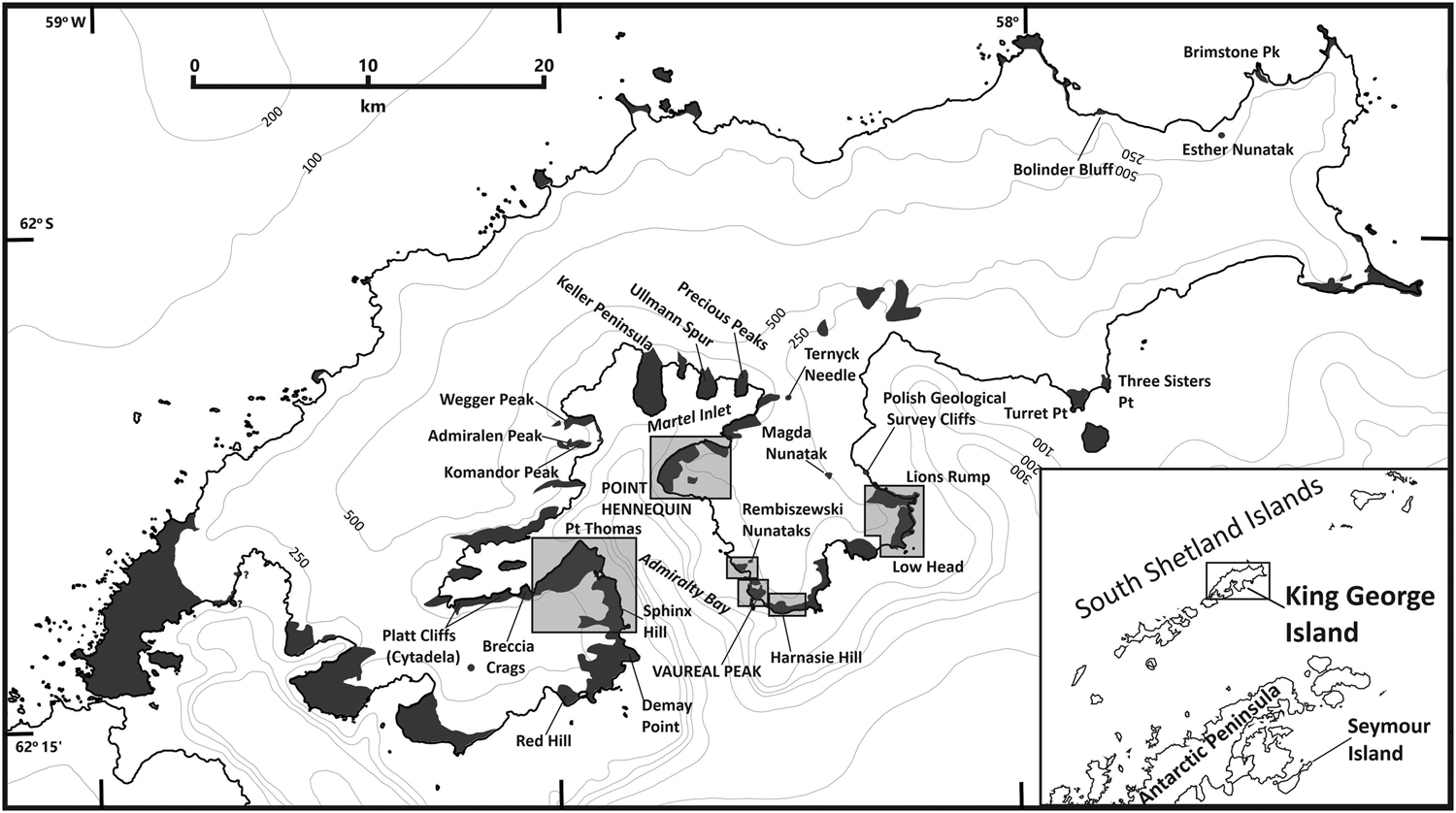
Fig. 1. Map of King George Island showing the distribution of rock outcrop (dark grey) and locations of places mentioned in the text. The shaded boxes show the locations of the field areas discussed in this paper and for which new geological maps are provided. The location of King George Island in relation to northern Antarctic Peninsula is shown in the inset.
After decades of geological research, the stratigraphy of the South Shetland Islands has been resolved into a great many geological units. This is particularly true for King George Island, which has one of the most complicated stratigraphies in Antarctica, involving 2 supergroups, 12 groups, 33 formations and numerous members divided between 5 tectono-stratigraphic structural blocks or terranes (summarized by Birkenmajer Reference Birkenmajer2001, Smellie Reference Smellie, Smellie, Panter and Geyer2021, fig. 6). Such a complicated stratigraphy is a direct consequence of the much easier logistical access and often limited alteration of the rocks on the island compared with other areas in the Antarctic Peninsula region. The King George Island stratigraphy has been supported by considerable dating, almost entirely by the K-Ar method (e.g. Watts Reference Watts and Craddock1982, Birkenmajer et al. Reference Birkenmajer, Narębski, Nicoletti and Petrucciani1983, Reference Birkenmajer, Soliani and Kawashita1989, Smellie et al. Reference Smellie, Pankhurst, Thomson and Davies1984). However, because of evidence for Ar loss and K-metasomatism, the validity of many of the published ages has been questioned, and thus significant aspects of the stratigraphy itself are in doubt (cf. Dupre Reference Dupre1982, Birkenmajer et al. Reference Birkenmajer, Soliani and Kawashita1990, Soliani & Bonhomme Reference Soliani and Bonhomme1994, Shiling et al. Reference Shiling, Xiangshen, Molan and Birkenmajer1996, Kraus, Reference Kraus2005, Pańczyk et al. Reference Pańczyk, Nawrocki and Williams2009, Nawrocki et al. Reference Nawrocki, Pańczyk and Williams2010, Reference Nawrocki, Pańczyk and Williams2011, Haase et al. Reference Haase, Beier, Fretzdorff, Smellie and Garbe-Schönberg2012).
The volcanism on King George Island is dominated by basalt to andesite lavas with island arc tholeiite to calc-alkaline compositions (Smellie et al. Reference Smellie, Pankhurst, Thomson and Davies1984, Haase et al. Reference Haase, Beier, Fretzdorff, Smellie and Garbe-Schönberg2012). Comparatively minor volcaniclastic and sedimentary deposits are also present, including fluvial and lacustrine beds and possible marsh deposits (e.g. Smellie et al. Reference Smellie, Pankhurst, Thomson and Davies1984, Shen Reference Shen and Shen1994, Dutra & Batten Reference Dutra and Batten2000, Mozer Reference Mozer2012, Reference Mozer2013). Many of the sedimentary deposits contain rich macro- and micro-floras, and King George Island is pre-eminent in Antarctica for its terrestrial palaeoenvironmental record, based largely on floral and fossil wood remains (e.g. Birkenmajer & Zastawniak Reference Birkenmajer, Zastawniak and Crame1989, Cao Reference Cao, Yoshida, Kaminuma and Shiraishi1992, Dutra & Batten Reference Dutra and Batten2000, Poole et al. Reference Poole, Hunt and Cantrill2001, Hunt & Poole Reference Hunt and Poole2003, Mozer Reference Mozer2012, Reference Mozer2013, Warny et al. Reference Warny, Kymes, Askin, Krajewski and Bart2016). The extensive isotopic dating on the island has demonstrated ages spanning the period between the Palaeocene and Early Miocene (e.g. Birkenmajer et al. Reference Birkenmajer, Narębski, Nicoletti and Petrucciani1983, Reference Birkenmajer, Delitala, Narębski, Nicoletti and Petrucciani1986, Reference Birkenmajer, Soliani and Kawashita1989, Smellie et al. Reference Smellie, Pankhurst, Thomson and Davies1984).
Coastal outcrops at Point Hennequin and Vauréal Peak, the principal field areas for this study, are situated on the east side of Admiralty Bay, King George Island (Fig. 1). The geology has been described by Barton (Reference Barton1965), Birkenmajer (Reference Birkenmajer1980, Reference Birkenmajer1981) and Smellie et al. (Reference Smellie, Pankhurst, Thomson and Davies1984). Point Hennequin is the type section for the Hennequin Formation, one of three major geographically widespread Late Cretaceous-Palaeogene volcanic divisions erected for the South Shetland Islands by Smellie et al. (Reference Smellie, Pankhurst, Thomson and Davies1984). It is distinguished by predominantly andesite lavas that are compositionally calc-alkaline. The locality is also the type section for the Point Hennequin Group, a more geographically restricted unit defined by Birkenmajer (Reference Birkenmajer1981; see also Barton Reference Barton1965). By contrast, the Vauréal Peak sequence has been little studied and has been mapped only at reconnaissance level (Birkenmajer Reference Birkenmajer1982). The previous work at Vauréal Peak described a varied succession of volcanic and minor glacial sedimentary deposits, with ages ranging from mid-Eocene (45.9 ± 0.7 Ma) to Early Miocene (17.3 ± 1.3 Ma; Birkenmajer et al. Reference Birkenmajer, Soliani and Kawashita1989). As a result of our investigation, we have significantly revised the stratigraphy and mapped distribution of the sequences at Point Hennequin, Vauréal Peak and other localities nearby. New geological maps are presented for all of the localities (Fig. 1). The fieldwork resulted in the discovery of a fossil flora at Vauréal Peak, which contains abundant wood and leaves. Samples were also obtained for isotopic dating of the volcanic rocks.
The purpose of this paper is to describe the lithostratigraphy of Palaeogene sequences principally at Point Hennequin and Vauréal Peak and to present them within a chronological framework using new and published 40Ar/39Ar isotopic ages. A preliminary description of the fossil flora at Vauréal Peak is also included. The new ages place temporal constraints on the evolutional context of the associated plant fossils, which are important for our perceived understanding of the Cenozoic palaeoenvironmental and palaeoclimatic evolution of Antarctica (e.g. Hunt & Poole Reference Hunt and Poole2003, Francis et al. Reference Francis, Ashworth, Cantrill, Crame, Howe, Stephens, Cooper, Barrett, Stagg, Storey and Stump2008, Cantrill & Poole Reference Cantrill and Poole2012).
Methods
Fieldwork was undertaken on King George Island principally in 1996 and 1999. Detailed mapping, essentially on a bed-by-bed basis, was carried out directly onto 1:10,000-scale air photographs taken in 1958 (Falkland Islands Dependencies Aerial Survey Expedition; FIDASE) and 1979 (HMS Endurance) and held at the British Antarctic Survey. Although the maps of the studied localities included in this paper show the solid geology, maps based on the distribution of actual rock exposure are also presented (Supplemental Information S1). Rock samples were taken for petrography, whole-rock geochemistry and 40Ar/39Ar isotopic dating, and fossil plants were taken for palaeobotanical studies. The isotopic dating was carried out at the University of Leeds and the New Mexico Geochronology Research Laboratory. Palaeobotanical analysis was undertaken at the University of Leeds. All rock and fossil samples are archived in the British Antarctic Survey Geological Specimens Collection, Cambridge (UK). A full summary of the dating methods used in this paper is included in Supplemental Information S2, whilst palaeobotanical techniques and preliminary taxonomic descriptions of the plant fossils are given in Supplemental Information S3.
Geological succession at Point Hennequin
Point Hennequin is a prominent flat-topped rocky bluff situated at the north end of Admiralty Bay on its east side. It rises to c. 290 m above sea level at Mount Wawel (also known as Wawel Hill; Fig. 2). The geological succession is relatively simple and composed mainly of thick lavas that dip gently (< 20°) to the north-east (Fig. 3). It was described in outline by Barton (Reference Barton1965) and Smellie et al. (Reference Smellie, Pankhurst, Thomson and Davies1984). Barton (Reference Barton1965) included all of the outcrops, extending east to the head of Martel Inlet, within his Point Hennequin Group; no constituent formations were identified. Smellie et al. (Reference Smellie, Pankhurst, Thomson and Davies1984) published a geological map of Point Hennequin based on the field notes of C.M. Barton. They included all of the strata at Point Hennequin within a single lithologically and petrologically distinctive Hennequin Formation, which was tentatively correlated with numerous exposures across much of eastern King George Island and on the west coast of Admiralty Bay. The only published detailed study of Point Hennequin is by Birkenmajer (Reference Birkenmajer1981), who defined the sequence as the Point Hennequin Group, including two formations with significantly different ages: Viéville Glacier Formation (older) and Mount Wawel Formation (younger), each with defined members. Like Barton (Reference Barton1965), it was suggested that the Mount Wawel Formation included volcanic outcrops to the east of Lussich Cove up to the head of Martel Inlet, although the reasons for the correlation were unspecified. A total stratigraphical thickness of > 500 m was proposed for the Point Hennequin Group, comprising at least nine andesite lavas and interbedded agglomerates, together with a substantial pyroclastic unit named the Loggia Agglomerate Member. Two intrusive plugs were also identified and named the Red Balcony Member, inferred to be coeval with the Viéville Glacier Formation, and the Arcades Member. The Arcades Member together with another unit called the Loggia Agglomerate Member were envisaged as the magmatic and pyroclastic infills, respectively, of a substantial neck complex associated with the Mount Wawel Formation. In addition, numerous sedimentary erratics, discovered by Barton (Reference Barton1965) in a terminal moraine flanking the Dragon Glacier (later informally named the ‘Dragon Glacier plant beds’), were found to contain an important and diverse fossil macroflora ('Dragon Glacier flora' of Hunt & Poole Reference Hunt and Poole2003). Together with trace fossils of arthropods, they have been the subject of several studies (e.g. Birkenmajer & Zastawniak Reference Birkenmajer, Zastawniak and Crame1989, Hunt & Poole Reference Hunt and Poole2003, Uchman et al. Reference Uchman, Gaździcki and Błażejowski2018). Additional palaeofloras were found in situ close to the summit of Mount Wawel and in loose blocks of well-sorted laminated tuff or sandstone at the foot of Smok Hill and were informally called the Mount Wawel and Smok Hill floras, respectively (Hunt & Poole Reference Hunt and Poole2003).
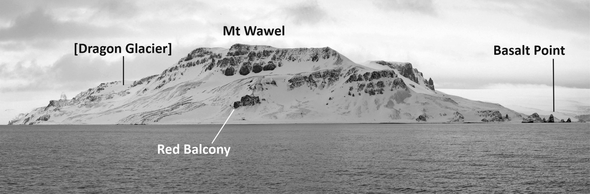
Fig. 2. View of Point Hennequin, looking east.
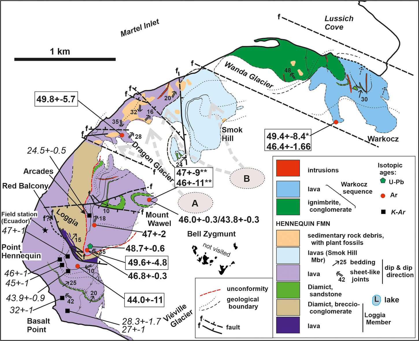
Fig. 3. Map of the solid geology of the Point Hennequin-Lussich Cove area, with published and new isotopic ages (ages from Dupre Reference Dupre1982, Smellie et al. Reference Smellie, Pankhurst, Thomson and Davies1984, Birkenmajer et al. Reference Birkenmajer, Delitala, Narębski, Nicoletti and Petrucciani1986, Nawrocki et al. Reference Nawrocki, Pańczyk and Williams2011). 40Ar/39Ar ages are shown in bold; those within rectangles are new ages reported in this paper; K-Ar ages are italicized. The possible source locations and inferred glacial transport directions (dashed grey arrows) for erratics containing the Dragon Glacier and Smok Hill palaeofloras are also shown (A and B, respectively). * = total gas age; ** = selective weighted-average age (see text for explanation).
Our interpretation of the Point Hennequin sequence differs in several important respects from that described by Birkenmajer (Reference Birkenmajer1981). The published stratigraphy, with division into two formations, was based on contrasting isotopic (K-Ar) ages for the Mount Wawel Formation (Late Oligocene: Birkenmajer et al. Reference Birkenmajer, Delitala, Narębski, Nicoletti and Petrucciani1986, Birkenmajer Reference Birkenmajer, Zastawniak and Crame1989) and for the Viéville Formation (Middle Eocene: based on ages in Smellie et al. Reference Smellie, Pankhurst, Thomson and Davies1984). However, Smellie et al. (Reference Smellie, Pankhurst, Thomson and Davies1984) noted that there is no lithological or petrological difference between the Mount Wawel and Viéville Glacier formations and, despite the presence of an internal possibly erosional surface (on top of the Loggia Member; see below), the strata are homoclinal throughout, which suggests that they are a single geological formation. Moreover, subsequent 40Ar/39Ar and U-Pb (zircon) dating by Nawrocki et al. (Reference Nawrocki, Pańczyk and Williams2011) and our new 40Ar/39Ar results (discussed below) indicate no significant age difference between the Mount Wawel and Viéville Glacier formations. They are therefore regarded here as a single stratigraphical unit and we retain the Hennequin Formation name for the entire sequence, as Smellie et al. (Reference Smellie, Pankhurst, Thomson and Davies1984) defined it. With just a single unit of formation status present, no group name is justified. However, part of the succession at Point Hennequin forms an additional lithologically discrete stratigraphical unit identified here for the first time. It is named the Smok Hill Member (described below; Table I). The Loggia Agglomerate Member is also renamed the Loggia Member, whereas the Arcades and Red Balcony members are removed from the stratigraphy, for reasons given below. Finally, outcrops between Wanda Glacier and Lussich Cove (Fig. 3) are different from those at Point Hennequin. As will be described later, similar distinctive lithologies also occur at Lions Rump, c. 10 km to the east-south-east (Fig. 1). The Wanda Glacier-Lussich Cove strata may merit designation as an independent stratigraphical unit, but their distribution and full characteristics are not sufficiently well known at present.
Table I. New Eocene stratigraphy.

The Hennequin Formation also includes informal stratigraphical units known as the Dragon Glacier and Mount Wawel plant beds; the Warkocz sequence includes the Wanda Glacier plant beds; the Carruthers Cliff Formation also includes the informal stratigraphical unit known as the Carruthers Cliff plant beds.
a Stratigraphical status uncertain; includes outcrops previously assigned to the Sukiennice Hills Formation (Polonia Glacier Group; Birkenmajer Reference Birkenmajer1994).
b New stratigraphical unit.
c Renamed stratigraphical unit.
d Includes dated correlatives across King George Island.
Hennequin Formation
The Hennequin Formation at Point Hennequin is distinguished lithologically by the presence of thick, grey to khaki-brown, basaltic andesite and andesite lavas with pale grey blocky and sparsely amygdaloidal autobreccias. At least 12 lavas are present, excluding thinner, less laterally persistent lavas in the Loggia and Smok Hill members (Fig. 3). One lava, at Red Balcony, is rhyolitic in composition (Table II), although the silicic composition may be affected by the strong alteration present and it is petrographically very like an andesite lava. The type section is taken as the prominent crags to the west and south-west of Mount Wawel. The lavas are distinguished by euhedral-subhedral lathy phenocrysts of plagioclase, often conspicuous anhedral augite, prismatic hypersthene, opaque oxide and minor euhedral microphenocrysts of apatite (Smellie et al. Reference Smellie, Pankhurst, Thomson and Davies1984). The combination of prominent, often flow-aligned lathy plagioclase and prismatic hypersthene phenocrysts dispersed within a glassy or very fine-grained (near-glassy) groundmass is particularly distinctive. The lavas are thick (i.e. rarely < 10 m), and the thickest is 65 m. The base and top are unexposed. The sequence is cut by several prominent faults with widely varying orientations. It has proven impossible to correlate individual lavas across major faults (e.g. across Dragon Glacier and Wanda Glacier). Because of possible repetition by the faults, the minimum thickness of the formation in its type area is difficult to estimate, but c. 500 m is realistic (Birkenmajer Reference Birkenmajer1981). Cooling joint patterns are also distinctive, and two types of lava can be identified on that basis; both types are interbedded. The most distinctive type displays prominent colonnade and entablature columnar joints (Fig. 4a). The colonnade is fine grained whereas the entablature is glassy to near-glassy. The second, more common, lava type is fine-grained and dominated by closely spaced curviplanar joints, which are often approximately bed-parallel but are locally steeply inclined and may form flattened cylindrical structures that extend through the full thickness of individual lavas (Fig. 4b). They are probably sheet-like joints (sensu Lescinsky & Fink Reference Lescinsky and Fink2000). A few lavas show both types of joints, such as the lava at Basalt Point, which displays a complicated set of joints, varying from a lower colonnade (base unexposed), overlying entablature, then an upper colonnade capped by a final section displaying sheet-like joints. The Basalt Point lava (which is an andesite; Table II) was interpreted as an intrusion by Birkenmajer (Reference Birkenmajer1981) and Smellie et al. (Reference Smellie, Pankhurst, Thomson and Davies1984), but the joint patterns and pervasively glassy nature of much of the outcrop are more characteristic of lavas.

Fig. 4. Photomontage of features of the Hennequin Formation at Point Hennequin. a. View of basal colonnade and overlying entablature in andesite lava below the Loggia Member. The basal columns are more widely spaced than those in the entablature. The hammer shaft is 70 cm in length. b. View of andesite lava showing locally developed, basal, poorly formed prismatic columns passing up rapidly into pervasive, closely spaced, sheet-like joints. The latter dip at shallow angles lower down but become steep-dipping higher up. Hammer (ringed) for scale. c. View looking east towards Mount Wawel showing Red Balcony (altered rhyolite lava), interbedded thin lavas (dark) and diamicts (pale) of the Loggia Member and the fault that separates the Loggia Member from lower lavas of the Hennequin Formation. Upper lavas of the Hennequin Formation are seen in the high cliffs behind. The orange building is c. 2.7 m high. d. Close view of muddy diamictite characteristic of the Loggia Member.
Table II. Summary of major oxides for lavas in mapped areas.
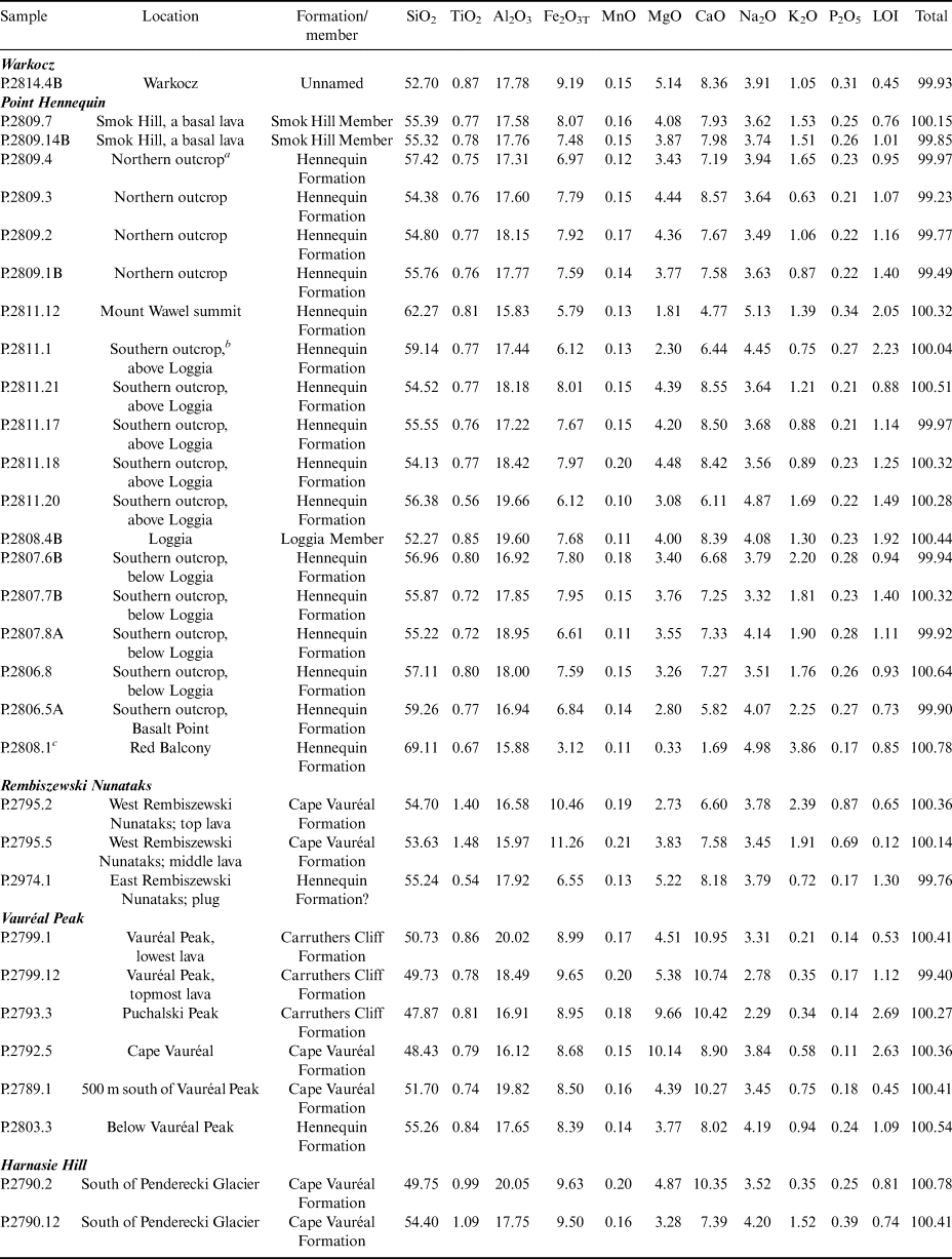
a North of Dragon Glacier.
b South of Dragon Glacier.
c Strongly altered and petrographically more like an andesite.
LOI = loss on ignition.
The Arcades Member, interpreted as a plug by Birkenmajer (Reference Birkenmajer1981), is reinterpreted as a columnar jointed type 1 lava. It onlaps the Loggia Member and is stratigraphically conformable within the lavas forming the upper sequence. The sheet-like cliff face exposure of the unit has a reduced basal colonnade and a much-expanded overlying entablature that thins in a northerly direction and is ultimately replaced by sheet-like joints that directly overlie the colonnade, all features of a lava rather than an intrusive plug.
The Red Balcony Member was similarly regarded by Birkenmajer (Reference Birkenmajer1981) as a small plug associated with his ‘Viéville Glacier Formation’. Neither the base nor the original top are exposed and the field relationships are unclear. The outcrop is small and isolated (Fig. 4c) and it has been extensively altered, either deuterically, by localized fault-related hydrothermal activity, or by deep subaerial weathering. It consists of friable, aphanitic grey-brown lava with pervasive, thinly spaced, moderate to steeply dipping, curviplanar sheet-like joints affected by rust-brown staining. The lava top surface is maroon and rust coloured and is coarsely brecciated, with prominent red staining between the angular lava blocks. The coloration extends up to 10 m down some of the irregular fractures. The origin of the Red Balcony outcrop, whether a lava or intrusion, is uncertain, but, on balance, it is probably just a lava > 35 m thick.
The lavas in the Hennequin Formation are interbedded with generally thin sedimentary deposits. They are usually poorly exposed and have not been well described (Fig. 3). The stratigraphically lowest sedimentary deposit, exposed 350 m north-east of Basalt Point, is just 2 m thick. It comprises a basal, soft sheared diamictite, c. 35 cm thick, composed of pale khaki mudstone and variably dispersed to closely packed, compressed dark green (?)vitric lapilli. The diamictite is overlain by 50 cm of thin-bedded, pale grey, rust-stained and manganese-coated mudstones and decimetre-thick lapilli-rich muddy diamictites, followed by 1 m of pale grey massive mudstone with rare fine sandstone interbeds individually < 5 cm thick. The upper mudstone becomes dark grey upward due to an increasing proportion of macerated carbonaceous plant debris.
The basal sedimentary unit overlying the Loggia Member was briefly described by Fontes & Dutra (Reference Fontes and Dutra2010). Situated on the west side of the termination of Dragon Glacier, it is c. 25 m in thickness and begins in c. 8 m of yellowish, green and brown finely laminated sandstones and fine tuffaceous sandstones showing repeated upward-fining cycles, bioturbation, desiccation cracks, raindrop impressions and ‘ichnofossils’ (undescribed; see also Hunt & Poole Reference Hunt and Poole2003 for critical comments on the possible misidentification of desiccation cracks in erratics at Point Hennequin). After an exposure gap of c. 6 m, the sequence continues as dark brown to grey tuffaceous sediment (lapilli-bearing; c. 2 m), followed by a thick, fining-upward succession of c. 6 m of green to yellow and red-green rocks described as ‘agglomerate, lapilli and tuff’ (possibly volcanic sandstones and breccio-conglomerate?). Loose clasts obtained nearby and believed to be sourced in the in situ sequence show asymmetrical and interference wave ripples. The topmost beds (c. 2.5 m) consist of massive green sandstones with a conspicuous root horizon up to 10 cm thick followed by tuffaceous sandstone with steep-faced cross-stratification, which grades up into cyclical beds of grey to dark grey fining-upward tuff. The sequence contains an in situ palaeoflora, including carbonized wood, believed by the authors to be a source for the abundant plant-bearing erratics surrounding the snout of the receding Dragon Glacier. However, the elevation of the sedimentary outcrop is probably too low to have been a major source of the erratics.
Another sedimentary unit c. 15 m thick is present high on the crags c. 400 m west of Mount Wawel and also contains an in situ palaeoflora ('Mount Wawel flora'; described by Hunt & Poole Reference Hunt and Poole2003). The basal 2 m is composed of thin-bedded, olive green, khaki and pale grey siltstone and sandstone in laterally continuous beds 1 cm to rarely 30 cm thick, which rest on deeply weathered (green and rust-stained) andesite lava autobreccia. Amalgamation and splitting of beds are present. Carbonaceous partings formed of crowded plant debris are common and there are coaly lenses up to 1 cm thick and 15 cm long. Some bed surfaces are crowded with quite well-preserved leaves, including angiosperms, ferns and coniferous material. The beds are planar laminated, with rare low-amplitude asymmetrical current ripples; a possible cross-cutting, compacted (?)worm burrow was also observed. The sequence changes up into olive green, massive fine to medium sandstone, then featureless brown mudstone with minor fine sandstone interbeds. This sedimentary unit is the probable source of fossil plants obtained from the lithologically similar detached arcuate outcrop (outlier) surrounding Mount Wawel (Fig. 3) and informally called the Mount Wawel plant beds (Hunt & Poole Reference Hunt and Poole2003).
Abundant lithologically varied sedimentary erratics, many with well-preserved floristically diverse plant fossils, also occur in moraine at the terminus of Dragon Glacier and below Smok Hill (e.g. Barton Reference Barton1965, Birkenmajer & Zastawniak Reference Birkenmajer, Zastawniak and Crame1989, Hunt & Poole Reference Hunt and Poole2003). Known collectively and informally as the Dragon Glacier plant beds (Birkenmajer Reference Birkenmajer1981), no similar deposits are exposed in situ anywhere at Point Hennequin. The erratics can be divided into two groups containing dissimilar floras known as the Dragon Glacier and Smok Hill floras (Hunt & Poole Reference Hunt and Poole2003). They are both believed to be coeval with the Point Hennequin sequence, with a similar source location. However, considering probable past ice flow patterns, the floristic differences and extrapolating the faults under Dragon Glacier and on the west side of Smok Hill, we suggest that there may be two different sources for the plant beds, both situated a few hundred metres east or east-north-east of Mount Wawel (Fig. 3). The Smok Hill flora is tentatively assigned to the Smok Hill Member.
Loggia Member (renamed unit): The Loggia Member is one of two stratigraphical subdivisions now formally identified within the Hennequin Formation. Originally called the Loggia Agglomerate Member by Birkenmajer (Reference Birkenmajer1981; Barton Reference Barton1965 also identified the agglomerate), the unit is not pyroclastic and the original name is therefore a misnomer. It is a sedimentary deposit interbedded with several lavas and is > 80 m thick; it includes the informally named ‘Mount Wawel conglomerate’ of Nawrocki et al. (Reference Nawrocki, Pańczyk and Williams2011). The unit is distinctive and easily mapped, and it is renamed the Loggia Member in this paper (Table I). Its upper surface rises to the south and is overstepped by lavas of the upper Hennequin Formation, although the surface is not exposed anywhere. It may have been eroded but it probably has no great time significance (see results of isotopic dating below). The lower contact is also unexposed but, on the south-west side of the outcrop, a steep arcuate fault is present, which juxtaposes the Loggia Member against lower lavas of the Hennequin Formation (former ‘Viéville Glacier Formation’; Fig. 4c). The dominant sedimentary deposits are composed of khaki-brown-coloured coarse diamictite and breccio-conglomerate with a crude stratification that dips at c. 15° to the north-east (Fig. 4d). The poorly defined massive beds are < 1 to > 6 m thick and are dominated by angular blocks of basaltic andesite lava up to c. 1 m in diameter (mainly 10–30 cm) set in c. 30–40% silt- to sand-grade matrix. Some clasts are abraded (subrounded-rounded; cf. the ‘Mount Wawel conglomerate’ of Nawrocki et al. Reference Nawrocki, Pańczyk and Williams2011) and others highly amygdaloidal and crudely bomb-like; the latter rarely and locally dominate some beds and may be the source of the misidentification of the entire unit as an agglomerate (Barton Reference Barton1965, Birkenmajer Reference Birkenmajer1981). The possible presence of altered rock fragments resembling granodiorite, recorded by Barton (Reference Barton1965, p. 24), was unconfirmed. It may refer to some of the pale-coloured, more weathered lava clasts crowded with feldspar phenocrysts, which can look crudely ‘plutonic’. The interbedded lavas are basaltic ‘a’ā, grey to brown or locally maroon coloured and aphyric to sparsely porphyritic, with very small phenocrysts. They form up to 30% of the Loggia Member at its southern end. The lavas are 2–12 m thick and vary from heavily fractured (including jigsaw fractures) to pervasively brecciated, formed of non-vesicular and scoriaceous lava clasts and lacking a fine matrix.
Smok Hill Member (new stratigraphical unit): Lavas forming Smok Hill form the upper part of the Hennequin Formation between Dragon Glacier and Wanda Glacier but the contact is unexposed. The Smok Hill sequence is distinctly different from that forming the Mount Wawel massif, and it is identified here as the Smok Hill Member after its type area. It is probably at least 200 m thick at Smok Hill, but the original full thickness is unknown as the top corresponds to the present-day erosional surface. The lavas are massive ‘a’ā, coarsely irregularly jointed and basaltic andesite in composition (Table II). They principally differ from the predominant lavas of the Hennequin Formation by being thinner, with prominent scoriaceous autobreccias and lacking the distinctive, well-formed prismatic and sheet-like joints. They are also crystalline rather than glassy and contain abundant phenocrysts of plagioclase; pyroxene phenocrysts are stubby and less conspicuous; and prismatic hypersthene phenocrysts are minor and small, differences ascribed to the generally more mafic compositions of the lavas emplaced during the Smok Hill eruptive episode. However, the lava compositions fall on the same evolutionary trends as those elsewhere in the Hennequin Formation, indicating a comparable petrological heritage. The stratigraphically lowest lava is atypically thick (c. 30 m). Those above are 5–10 m thick and several are laterally discontinuous lobes. Greenish-grey scoriaceous autobreccia zones up to 5 m thick are prominent and may form up to 20% of the sequence, with a red-coloured example (oxidized?) present towards the top of the section. Only a single sedimentary deposit was observed on Smok Hill (Fig. 3). It is 60 cm thick and occupies a shallow hollow eroded in the underlying lava. The deposit consists of soft, crumbly, purple-brown and green fissile siltstones and very fine sandstones lacking plant fossils.
Warkocz sequence: Poorly exposed lavas in the Warkocz area (Fig. 3) are mafic basaltic andesites and they contain numerous small phenocrysts replaced by microgranular opaque oxide (probably either olivine or amphibole). The Warkocz sequence also includes interbedded thick (c. 10–30 m), massive, grey, green and brown muddy diamictites that have a distinctive ignimbritic appearance caused by prominent flattened fiammé-like to angular (broken) juvenile clasts 1–4 cm thick and up to 20 cm long. Minor green medium sandstones to granule conglomerates are also present and may include the ‘conglomerate containing large water-worn pebbles’ on the south side of Lussich Cove recorded by Barton (Reference Barton1965). In addition, rare poorly preserved plant fossils occur in clasts in a moraine on the northern flank of Wanda Glacier. Informally called the Wanda Glacier plant beds by Birkenmajer (Reference Birkenmajer1981), the preservation is poor (typically carbonized fragments) and the fossils have never been described. The Warkocz strata are steeply dipping (30–50° to the north-west and north-east), defining a large-scale, open, anticlinal sigmoidal fold, suggesting that significant strike-slip faults may be present beneath Wanda Glacier and Lussich Cove. Although both Barton (Reference Barton1965) and Birkenmajer (Reference Birkenmajer1981) included the Warkocz sequence in their Point Hennequin Group, the differences between the Warkocz sequence and the Hennequin Formation (as defined in this paper) appear to be significant, and the basis for a correlation is not obvious. The full characteristics and distribution of the Warkocz sequence on King George Island are not well known, but strata very similar to those at Warkocz also occur at Emerald Crag near Lions Rump, c. 10 km east-south-east of Warkocz (Fig. 1), where they unconformably overlie lavas of the Hennequin Formation (see later). The stratigraphical affinities of the Warkocz and Emerald Crag strata are currently uncertain. They are therefore not assigned to any formation (Table I).
Geological successions at Rembiszewski Nunataks, Vauréal Peak and Harnasie Hill
Volcanic outcrops are also extensively exposed between Rembiszewski Nunataks and Harnasie Hill, situated 7–10 km south-east of Point Hennequin (Figs 1 & 5). The stratigraphy is relatively simple, but there are many discrepancies between our study and the mapped relationships published by Birkenmajer (Reference Birkenmajer1982). In particular, outcrops previously attributed to several Oligocene volcanic formations (Boy Point, Martins Head and Dunikowski Ridge formations) are reassigned to three Eocene stratigraphical units (i.e. the Hennequin Formation and two new formations defined in this paper). Two other formations, said to be of Oligocene age, also crop out near Vauréal Peak and comprise outliers of the Polonez Cove and Vauréal Peak formations (Birkenmajer Reference Birkenmajer1982). Both are composed of glacially related sedimentary deposits. The Polonez Cove Formation forms a tiny isolated outcrop about midway between Cape Vauréal and Vauréal Peak (Fig. 6). The presence of a second outcrop of the Polonez Cove Formation, identified north-east of the summit of Vauréal Peak by Birkenmajer (Reference Birkenmajer1982), was not confirmed during our study. The Vauréal Peak Formation (also informally called the Vauréal Peak tillite) additionally drapes a poorly exposed small lava outlier of the Carruthers Cliff Formation at Puchalski Peak (Fig. 6), but the outcrop inferred to be present at Rembiszewski Nunataks (Birkenmajer Reference Birkenmajer1982) does not exist (Fig. 7). The two Oligocene sedimentary formations are not further discussed in this paper.
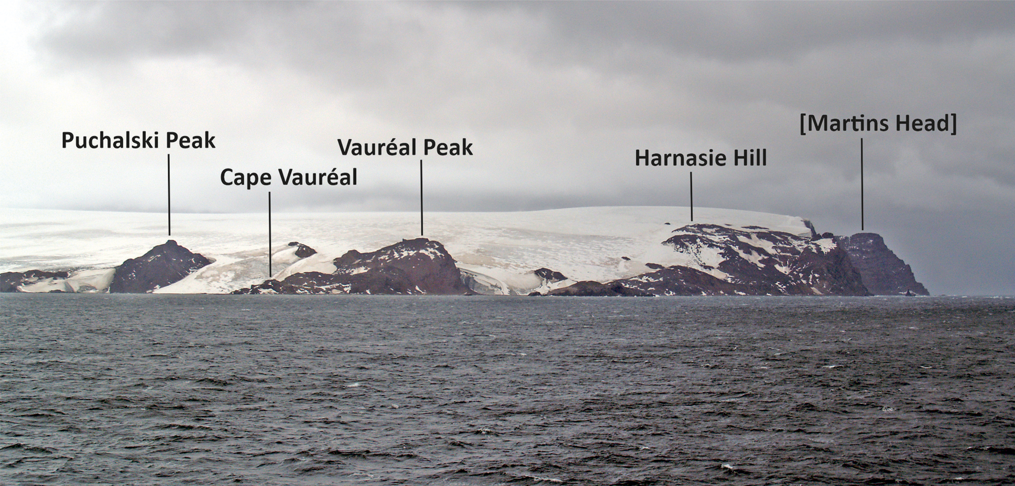
Fig. 5. View looking east at localities visited on the east coast of Admiralty Bay between Puchalski Peak and Harnasie Hill.

Fig. 6. Map showing the solid geology of the Vauréal Peak area. New 40Ar/39Ar ages are shown in bold and within rectangles; K-Ar ages are italicized.
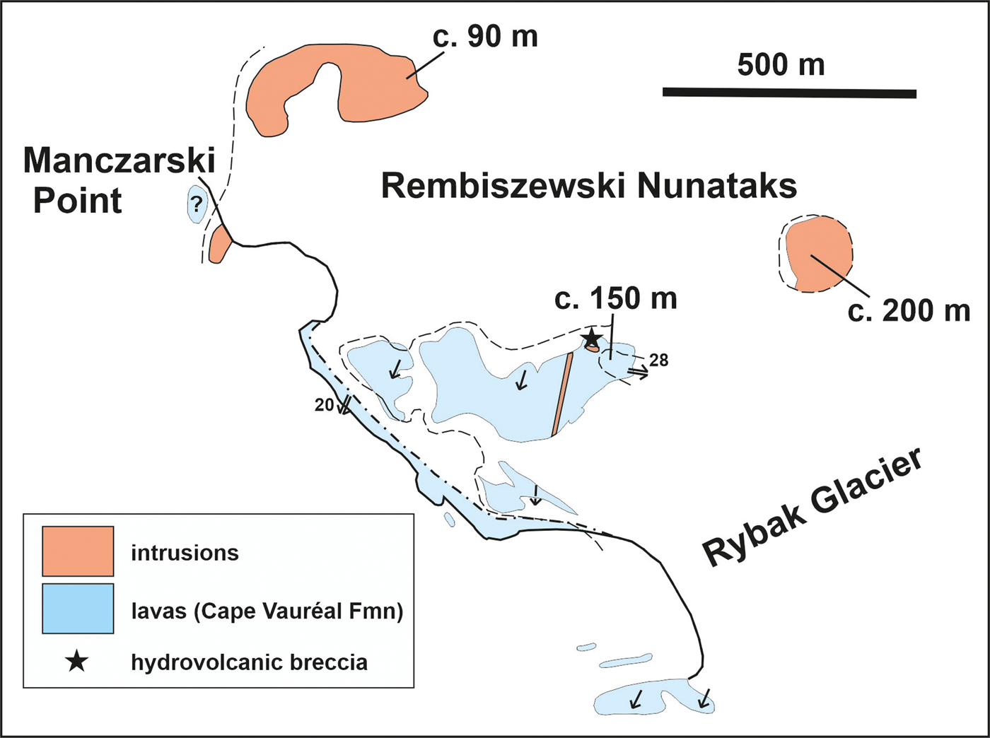
Fig. 7. Map showing the solid geology of Rembiszewski Nunataks. Although the lavas are correlated with the Cape Vauréal Formation, the easternmost unnamed nunatak is a plug that lithologically and compositionally closely resembles lavas in the Hennequin Formation. The characteristics and affinities of the other intrusion shown are unknown.
Hennequin Formation
An oval outcrop of weathered basaltic-andesite lava (Table II) forms one of the oldest stratigraphical units in the Vauréal Peak area (Fig. 6). The lava is khaki-brown, very fine grained to glassy and contains abundant locally flow-aligned phenocrysts of platy feldspar and prismatic hypersthene and large anhedral clinopyroxene phenocrysts, together with much smaller opaque oxide and numerous altered (?)olivines. Much of the rock is massive and irregularly jointed, but columnar jointing is developed at the south-west extremity of the outcrop, together with more widely developed sheet-like joints. Although interpreted as a Martins Head Formation plug by Birkenmajer (Reference Birkenmajer1982) because of the columnar jointing, the outcrop is probably an eroded relict of a lava, with colonnade and entablature prismatic jointing. It subsequently yielded a K-Ar isotopic age of 45.9 ± 0.7 Ma (Birkenmajer et al. Reference Birkenmajer, Soliani and Kawashita1989). Only one lava seems to be present, with a thickness of c. 80 m. In its thickness, lithology, jointing, composition and age, the lava is indistinguishable from the Eocene Hennequin Formation, with which it is now correlated.
The easternmost of the Rembiszewski Nunataks is a circular outcrop rising to c. 200 m with very gently dipping (c. 0–20°) columnar joints radiating outward on all sides (Fig. 7). It is herein interpreted as a plug. Although no contacts with other rocks are exposed and the outcrop is undated, it is a calc-alkaline silica-poor andesite with strong compositional affinities with the Hennequin Formation (Table II).
Cape Vauréal Formation (new stratigraphical unit)
Extensive exposures of lavas form low seaward-facing crags at Cape Vauréal/Sharman Point and the foreshore between Geologists Cove and Włodek Cove (Fig. 6). Related outcrops also occur on the west side of Harnasie Hill, at Rembiszewski Nunataks and the foreshore between Włodek Cove and Manczarski Point (Figs 7 & 8). The outcrops around Cape Vauréal were correlated with the ‘andesitic’ Martins Head (Birkenmajer Reference Birkenmajer1982) or Dunikowski Ridge (Birkenmajer et al. Reference Birkenmajer, Soliani and Kawashita1989) formations (both of which are overwhelmingly basaltic; Smellie et al. Reference Smellie, Pankhurst, Thomson and Davies1984, and unpublished data of JLS). Two samples of lava from Cape Vauréal and the foreshore facing Chabrier Rock yielded K-Ar isotopic ages of 33.4 ± 4.1 and 28 ± 3.1 Ma (Birkenmajer et al. Reference Birkenmajer, Soliani and Kawashita1989), ages that are now known to be too young (see later). Moreover, the Polonez Cove Formation at Vauréal Peak contains abundant lava fragments derived from the Cape Vauréal Formation. The Polonez Cove Formation is also Oligocene in age, but it is older than the Martins Head Formation, thus implying a pre-Oligocene age for the Cape Vauréal Formation.

Fig. 8. Map showing the solid geology of the Harnasie Hill area.
The Cape Vauréal lavas are tholeiitic (Fig. 9). They differ lithologically and compositionally from calc-alkaline lavas of the Oligocene Martins Head and Dunikowski Ridge formations and from those in the Eocene Hennequin Formation (including the Smok Hill Member). They thus deserve separate stratigraphical status as the Cape Vauréal Formation, named after the type area (Table I). Although unvisited during our study and regarded by Birkenmajer (Reference Birkenmajer1982) as an early Miocene plug, Chabrier Rock appears from binocular observations to be a columnar- to platy-jointed lava indistinguishable from other lavas in the new formation, and it is therefore also included. The top and base of the formation are unexposed but are inferred to be unconformities on the basis of different bedding attitudes from surrounding formations and extrapolated field relationships. It is unclear how thick the Cape Vauréal Formation is overall because of the scattered and isolated nature of the exposures. It is several tens of metres thick, at least, in each of the three main outcrop areas (Cape Vauréal-Vauréal Peak, Harnasie Hill and Rembiszewski Nunataks), but the cumulative thickness is unknown.

Fig. 9. AFM and FeOT vs SiO2 discriminant diagrams for Eocene lavas on King George Island showing varied calc-alkaline and tholeiitic affinities. See Table II for data. Analyses recalculated to 100% anhydrous.
The Cape Vauréal Formation is dominated by relatively thick (c. 10–20 m), khaki-grey basalt and basaltic andesite lavas (Table II), which are holocrystalline and mainly aphyric to sparsely feldspar-phyric; clinopyroxene and altered olivine phenocrysts may also be present but are small and inconspicuous. Most of the lavas have a distinctive platy appearance caused by prominent close-spaced, gently dipping sheet-like joints (Fig. 10a). Coarse, crude columnar joints are also developed centrally in the upper of the two lavas that crop out at Cape Vauréal itself and at Chabrier Rock. Conversely, at least one lava (dated; see later) contains prominent lathy plagioclase, a few rounded pyroxene and prismatic hypersthene and altered olivine phenocrysts together with a very fine-grained groundmass. Moreover, sheet-like joints in the lava are poorly developed. Texturally and mineralogically it resembles a relatively mafic Hennequin Formation lava. However, it appears to be homoclinal and interbedded with aphyric lavas of the Cape Vauréal Formation and compositionally it falls within the tholeiitic fractionation trend of the formation. It is therefore regarded as an integral part of the Cape Vauréal Formation. The sequence generally dips at < 30° to the south-south-west (Fig. 6). Lava surfaces are seldom exposed but comprise very thin (c. 50 cm) zones of purple, grey and red-stained weathered amygdaloidal to scoriaceous lava. In outcrops at Rembiszewski Nunataks and Harnasie Hill, the lavas are intruded by dolerite sills, and a breccia formed of finely vesicular, very fine-grained to glassy clasts locally cuts across the middle lava at Rembiszewski Nunataks (Figs 7 & 8). Lavas at Harnasie Hill are interbedded with monomict lava breccia up to 6 m thick, green-coloured pebble to boulder conglomerates and red-brown mud-rich polymict diamictite with numerous flattened juvenile lapilli. Two ignimbrites are also present at the top of the Harnasie sequence at Cape Syrezol (cf. ignimbrite strata at Warkocz and Emerald Crag; Fig. 8). The upper ignimbrite is c. 3 m thick, welded and cut by a plug-like intrusion, whereas the lower ignimbrite is c. 7 m thick, friable and unwelded. The two are separated by c. 2 m of cobble and boulder conglomerate.

Fig. 10. Photomontage of features of the volcanic sequences in the Vauréal Peak area. a. Close view of prominent, well-developed, sub-horizontal, platy sheet-like joints within a basalt lava at Cape Vauréal (Cape Vauréal Formation). The hammer shaft is c. 70 cm long. b. View of Carruthers Cliffs showing steeply inclined basalt lavas overlying conglomerates, sandstones and diamictites of the Carruthers Cliff plant beds. The lavas show prominent prismatic cooling joints. The location of the fossil leaf locality is also indicated. A stratigraphical thickness of c. 80 m of exposed rock is shown. c. View of the basal thick basalt lava at Carruthers Cliffs, below Vauréal Peak, showing prominent division into colonnade and entablature prismatic joints (Carruthers Cliff Formation). The basal colonnade is c. < 1.5 m thick in this view.
Carruthers Cliff Formation (new stratigraphical unit)
Vauréal Peak is a small hill rising to c. 180 m above sea level that is mainly formed of steeply south-west-dipping (c. 45°) basalt lavas (Fig. 10b). The formation is principally exposed at Vauréal Peak (the type section), but it also occurs as small inliers draped by tillite of the Vauréal Peak Formation at Puchalski Peak (Fig. 6). A lava sample taken from a possible additional small isolated outcrop, composed of lava breccia and polymict matrix-supported breccia, situated c. 450 m west-north-west of Vauréal Peak, yielded a K-Ar age of 17.3 ± 1.3 Ma, regarded as unreliable and significantly younged (Fig. 6; Birkenmajer et al. Reference Birkenmajer, Soliani and Kawashita1989). The dated outcrop and the larger outcrop forming Vauréal Peak itself were included by Birkenmajer (Reference Birkenmajer1982) in the Oligocene Boy Point Formation (see also Birkenmajer et al. Reference Birkenmajer, Soliani and Kawashita1989), which crops out extensively between Lions Rump and Low Head (Fig. 1). However, the Boy Point Formation is a highly distinctive calc-alkaline andesite-dacite formation compositionally dissimilar to the Vauréal Peak sequence. Our dating has now unequivocally demonstrated an Eocene age for Vauréal Peak lavas (see below), and the sequence is here formally named the Carruthers Cliff Formation. Because of its tholeiitic compositions, similar to those of the Cape Vauréal Formation (Fig. 9 & Table II; unpublished data of JLS), both formations are combined within the Penderecki Glacier Group (new stratigraphical unit; Table I).
Thin-section examination of the dated small isolated breccia outcrop shows that it has petrographical characteristics (abundant green and brown hornblende, a particularly distinctive phenocryst phase, uncommon in volcanic rocks of the South Shetland Islands; Smellie et al. Reference Smellie, Pankhurst, Thomson and Davies1984) that are indistinguishable from younger (Oligocene) volcanic strata exposed to the east, including the Boy Point Formation of Birkenmajer (Reference Birkenmajer1982). Although the small outcrop is in situ and may be a distal outlier of the Boy Point Formation, it may also be a megaclast several metres in diameter contained within the margin of the Vauréal Peak Formation (a glacial diamict); a much smaller block of sandstone with abundant hornblende phenoclasts, indicating a similar provenance, also occurs within the margin of the Vauréal Peak Formation c. 100 m to the south.
Lavas in the Carruthers Cliff Formation are crystalline basalts (Table II). They are conspicuously porphyritic, with abundant relatively large plagioclase phenocrysts, numerous altered olivine and smaller and fewer anhedral pyroxene phenocrysts. The lowest lava in the sequence is also the thickest. It contains a prominent thin basal colonnade (up to 5 m thick), with well-formed columns, and a much thicker (to 20 m) entablature (Fig. 10b & c). Overlying lavas are thinner (20, 10 and 3 m, becoming thinner up-section) and massive, although the 20 m lava contains a poorly formed colonnade. Each lava is encased in grey scoriaceous autobreccia, and the stratigraphically uppermost lava overlies a bed of bright red-coloured muddy diamictite. The lavas overlie the uneven surface of a sedimentary sequence exposed at the base of Carruthers Cliff (Fig. 10b). It is composed of interbedded fine and coarse conglomerate, medium to coarse sandstone and coarse diamictite, and it contains abundant plant remains. The sedimentary sequence is here named the Carruthers Cliff plant beds and it is described more fully below. The entire sequence at Vauréal Peak and Carruthers Cliff forms an oval-shaped outcrop. Because of its age (the oldest in the area; see below) and much steeper dips (c. 45°), it is presumably overlain unconformably by the other formations present, although no contacts are exposed. The steep dips of the bedding are unlikely to be depositional and the formation has probably been affected by tilting; none of the other formations are obviously affected by tectonism. The base of the formation is also unexposed, but it has an estimated thickness of at least 100 m.
The Carruthers Cliff plant beds and associated fossil flora
Description of the plant beds
Sedimentary deposits are well exposed below Vauréal Peak on the south side, at the base of Carruthers Cliff and in the adjacent small valley. Although the basal thick diamict deposit (local unit 1; Fig. 11) has not yielded any plant fossils so far, all of the exposed sediments are currently included in the Carruthers Cliff plant beds for convenience of description. The stratigraphically lowest exposed part of the sedimentary sequence consists of massive, dark grey-green to khaki-brown diamictite and gravel-rich conglomerate at least 30–40 m thick (local unit 1). It is formed of angular to subrounded, rarely rounded polymict granules to boulders up to 25 cm dispersed in abundant brown-coloured siltstone to gravel-sized matrix. The deposit seemingly varies randomly from boulder conglomerate to pebbly mudstone diamictite. Many clasts < 2 cm in diameter may be monomict, dominated by khaki-yellow juvenile lapilli. Larger clasts are entirely of local lava provenance (Carruthers Cliff Formation) and form 40–70% of the rock. Above the diamictite (no contacts exposed) and possibly occupying a small erosional hollow at c. 60 m elevation (estimated) is a thin sequence (< 2 m thick) of poorly exposed thin-bedded pale green granule conglomerate, fine sandstone and fissile muddy diamictite (local unit 2). The thin sequence contains several sub-centimetre-thick coaly lenses, and a basal sandstone bed is crowded with leaf fossils of several morphotypes (described below).
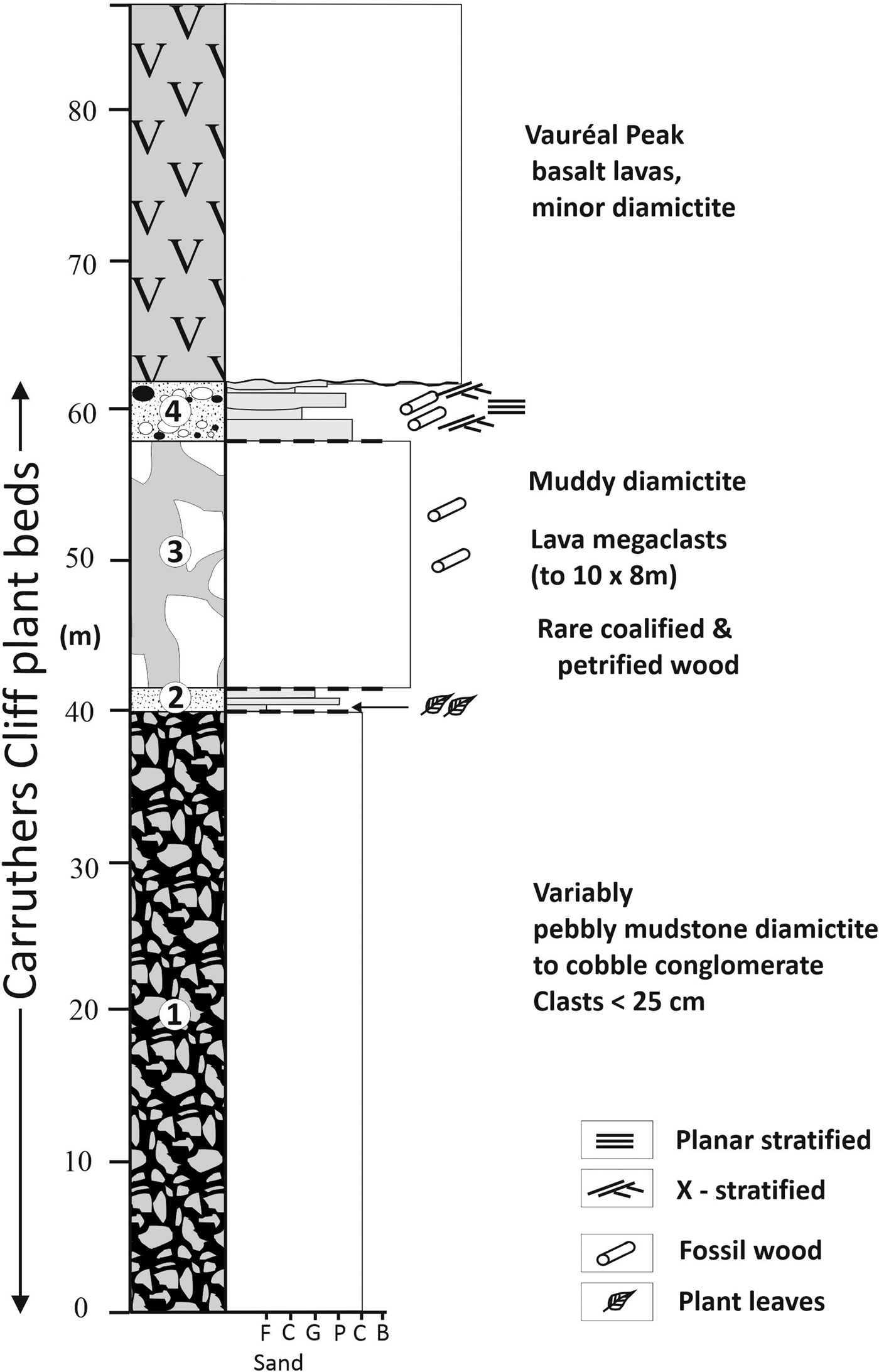
Fig. 11. Graphic sedimentary section through the Carruthers Cliff plant beds at Vauréal Peak. The numbers shown in the log refer to informal local units described in the text. F = fine (sand); C = coarse (sand); G = granule; P = pebble; C = cobble; B = boulder.
Above the fossiliferous beds (contact unexposed) and cropping out along the base of Carruthers Cliff is a sequence of coarse diamictite (15–20 m thick, thinning to < 10 m down-dip) overlain by interbedded conglomerate and sandstone (c. 4 m thick); the sandstones are locally crowded with coalified plant debris (mainly stems; not further described). This is a notable difference with the palaeofloras at Point Hennequin, in which wood is extremely uncommon. The diamictite (local unit 3) is a spectacular deposit. It contains abundant polymict clasts of local lavas together with rare coalified wood stems or branches up to 70 cm long by 2.5 cm thick, dispersed in sheared dark brown muddy matrix; a broken bough measuring 40 cm long and 6 cm thick was also seen. The lava fragments include numerous megaclasts measuring up to 10 m wide and 8 m high, which are pervasively jigsaw fractured. Part of the deposit also consists of coarse conglomerate. Conglomerates in the overlying conglomerate-sandstone sequence (local unit 4) are dominated by well-rounded pebbles to boulders composed of locally derived lavas dispersed in pale green gravelly to very coarse sandstone matrix (c. 15–30%) that is dominated by juvenile lapilli. Parts of the deposit are fine gravel and sandstone with few coarser clasts. Some sandstones contain sparse grains of green hornblende, unlike the overlying lavas. Bedding is lenticular on a scale of a few to several metres laterally (down-dip). The individual conglomerate beds are up to c. 1.5 m thick, massive (mainly) or show faint planar stratification. Some shallow cross-cutting scour surfaces and faint low-angle cross-stratification are also present in sandstone beds 2–3 cm thick.
Description of the fossil flora
The low-diversity, relatively poorly preserved fossil flora within the Carruthers Cliff sequence cannot be use to refine the age of the associated sediments. Only a summary of the main floral elements is presented here. Fuller descriptions are included in Supplemental Information S3. The main fossil horizon is poorly exposed (largely scree-obscured). It contains five angiosperm taxa and ferns. Leaves are preserved as impressions parallel and perpendicular to bedding and frequently occur as mats; they lack cuticle. For descriptive purposes, the specimens are grouped into form genera (morphotypes). At least six leaf morphotypes are identified, comprising both angiosperms and non-angiosperms (Fig. 12). The angiosperms comprise entire-margined brochidodromous and eucamptodromous veined leaves and toothed-margined pinnately and palmately lobed leaves similar to Nothofagus species. Many of the fossiliferous sandstone slabs collected are dominated by a single nothofagaceous angiosperm morphotype. Only a single non-angiosperm morphotype was found in the Carruthers Cliff plant beds (i.e. a fertile fern resembling Gleichenia). Overall, the flora is distinctive in containing leaf mats composed of abundant ferns together with angiosperm leaves suggesting a single Nothofagus species. Fossil wood is also locally common and there is evidence for herbivory (McDonald et al. Reference McDonald, Francis, Compton, Haywood, Ashworth, Hinijosa, Smellie, Cooper, Barrett, Stagg, Storey, Stump and Wise2008).
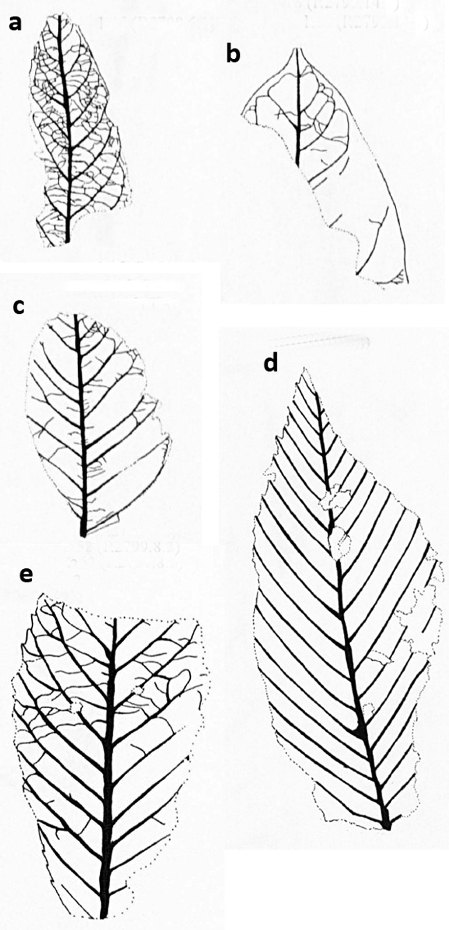
Fig. 12. Photomontage of line drawings showing representative Carruthers Cliff angiosperm leaf morphotypes. a. Morphotype 1A (P.2799.6.1). b. Morphotype 1B (P.2799.14.1). c. Morphotype 1C (P.2799.1.2). d. Morphotype 2A (P.2799.8.1). e. Morphotype 2B (P.2799.8.2). The scale bar in each example is 1 cm long. See Supplemental Information S3 for detailed descriptions.
Results of new 40Ar/39Ar dating
Details of the methods used, analytical information, step-heating spectra and isotope correlation plots for all of the dated samples are provided in Supplemental Information S2. All errors quoted here are 2σ. The sample locations and ages are shown in Figs 3 & 6 (see also Supplemental Information S1). Selected representative 40Ar/39Ar spectra are shown in Fig. 13.
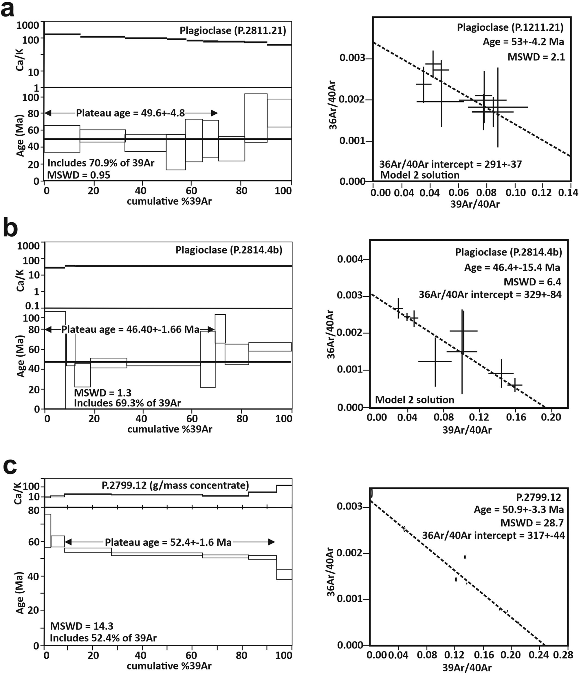
Fig. 13. Representative 40Ar/39Ar plateau spectra and isotope correlation diagrams for Eocene lavas on King George Island, illustrating variable quality of results. See text for details. a. Moderately well-defined plateau, high 2σ errors; P.2811.21 (Hennequin Formation). b. Very disturbed plateau, variable 2σ errors; P.2914.4b (Warkocz). c. Well-defined plateau, small 2σ errors; P.2799.12 (Carruthers Cliff Formation). See text and Supplemental Information S1 for details of interpretation.
Point Hennequin
Five lava samples from the Point Hennequin area were dated. All have high 2σ errors but, apart from a single problematic sample, they indicate an Eocene age. Sample P.2807.6b is the uppermost lava in the lower sequence (formerly Viéville Glacier Formation), faulted against the Loggia Member. The sample produced a somewhat curved, slightly saddle-shaped age spectrum. The variations correlate with minor variations in the Ca/K ratio at low and high temperatures. A plateau age based on 100% of the 39Ar is 42 ± 2.4 Ma, identical within error to the isotope correlation age of 42.5 ± 2.6 Ma (Table III & Supplemental Information S2). However, a weighted mean age of 44.0 ± 11 Ma, based on 63% of the gas released, obtained from the low-error high-gas-volume central steps on the age spectrum, is more consistent with other age data from the same sequence and is the age used in Fig. 3. All of the ages have probably been younged somewhat.
Table III. New 40Ar/39Ar ages.

Notes: Preferred ages shown in bold. NMGL = New Mexico Geochronology Laboratory; n = number of heating steps; %39Ar = total fraction of gas released used in the calculation of the weighted mean age; WR = whole rock.
a 30–60 and 60–90 μm sieved sample splits.
Sample P.2811.21, from a lava that oversteps the Loggia Member in the middle of the Mount Wawel lava sequence, yielded a plateau age of 49.6 ± 4.8 Ma based on six disturbed steps constituting 70.9% of the 39Ar released (Fig. 13). The plateau age is identical within error of the total gas age of 52.2 ± 5.6 Ma and also the isotope correlation age of 48.1 ± 11.4 Ma.
Sample P.2809.4 is from a lava in the northern lava outcrop flanking Dragon Glacier (Fig. 2). It yielded a plateau age of 50.2 ± 2.8 Ma. Some disturbance has affected the low-temperature steps and is correlated with the Ca/K ratios, indicating minor alteration. The isotope correlation age of 49.1 ± 5.6 Ma is well constrained and within error of the plateau age. A weighted average age is also possible. If the initial three high-error steps are discarded, the plateau age reduces to 49.8 ± 5.7 Ma based on 87.1% of the 39Ar released, and this is the preferred age.
Sample P.2811.12 is from the summit of Mount Wawel. Plateau ages of 39.1 ± 2.2 and 39.9 ± 1.9 Ma were obtained on different sieved size fractions of plagioclase separates and have good isotope correlations (c. 39 Ma). However, a whole-rock analysis, which yielded a weighted mean age of 34.39 ± 0.68 Ma, shows a classic Ar loss profile indicating all three ages are probably problematic (Supplemental Information S1). High loss on ignition values and low Ca/K ratios indicate that Ar loss has occurred and all of the ages are too young. The lithology sampled also has a high proportion of glass, and devitrification is a common cause of Ar loss. The high-temperature steps may also define a separate plateau, possibly suggesting further Ar loss. The weighted average ages of the final steps are 46 ± 11 and 47 ± 9 Ma, which are more consistent with the ages of the underlying samples (especially P.2811.21, the stratigraphically closest-dated sample, also from the upper sequence), the field relations and ages on the same lava by Nawrocki et al. (Reference Nawrocki, Pańczyk and Williams2011). Despite the high errors, the weighted average ages are therefore likely to represent more closely the crystallization age of the sample.
Sample P.2814.4b was taken from one of the lavas in the upper part of the sequence at Warkocz. The sample yielded a noisy spectrum showing little correlation with the Ca/K ratios (Fig. 13). Some of the age scatter relates to large relative errors resulting from the release of very small gas volumes. The plateau age of 46.40 ± 1.66 Ma comprises 69.3% of the 39Ar, whilst the IsoPlot ‘Model 1’ isotope correlation age is 49.1 ± 5.6 Ma. An alternative IsoPlot ‘Model 2’ isotope correlation age of 46.4 ± 15.4 Ma is also possible and is well constrained by the main plateau steps. Despite the disturbed spectrum, the total gas age is 49.4 ± 8.4 Ma, which, together with the ‘Model 1’ age, is closer to other samples with good plateau spectra in the Hennequin Formation. At present, the true eruption age of the Warkocz lavas is not well defined and may be either 46.4 ± 1.66 or 49.4 ± 8.4 Ma.
Vauréal Peak and Harnasie Hill
Four samples from the Vauréal Peak-Harnasie Hill area were dated. Samples P.2789.1 and P.2792.4, from the Cape Vauréal Formation, are from widely separated exposures that are possibly parts of the same lava (Fig. 6). Sample P.2792.4 yielded an almost flat plateau except for the lowest- and highest-temperature steps, which correlate with noise in both Ca/K and Cl/K ratios, indicating minor alteration has affected the plagioclase grains. The plateau age of 49 ± 2 Ma shows a good comparison with the isotope correlation age of 48.6 ± 8.2 Ma. Given the low noise in the spectrum for sample P.2792.4 and its low Ca/K and Cl/K ratios, as well as visibly fresh plagioclase in thin section, 49 ± 2 Ma is the probable age for the sample. Sample P.2789.1 has a disturbed spectrum that matches variations in the Ca/K ratios, signifying some alteration. The plateau age of 55.4 ± 7.6 Ma is based on 100% of the 39Ar and is within error of the isotope correlation age of 54.6 ± 15.4 Ma, although the latter has high errors resulting from low gas release volumes. However, a slight saddle in the spectrum at high temperatures may indicate the incorporation of excess Ar in the sample. The sample has a total gas age of 50.9 ± 14.6 Ma. If the two samples are from the same lava, the error ranges on the plateau ages brings them closer together, and an age of 49 ± 2 Ma is the preferred eruptive age.
Samples P.2799.1A and P.2799.12 are from the lowest and highest lavas, respectively, in the sequence that forms Vauréal Peak (Carruthers Cliff Formation). Both of the samples yielded somewhat discordant age spectra (described in detail in Supplemental Information S2) but consistent ages of 51.5 ± 3.6 and 53.1 ± 1.6 Ma (Fig. 13). Because of the relatively large 2σ errors, the ages are indistinguishable. The age spectrum for P.2799.1A is less precise than for P.2799.12. A minimum age of 49 ± 1 Ma is provided by lavas of the Cape Vauréal Formation exposed nearby, which field relationships indicate are younger than the Carruthers Cliff Formation. Thus, an Early Eocene age of c. 52 Ma is preferred for the Carruthers Cliff Formation, making it the oldest geological unit examined during our study.
Discussion
Eocene volcanism on eastern King George Island
Based on our detailed mapping of field relationships between the major stratigraphical units, whole-rock analyses and the published and new isotopic dating (mainly by 40Ar/39Ar), at least three Eocene volcanic formations are now identified on eastern King George Island, and a fourth Eocene formation may be represented by strata at Warkocz. The formations overlap in age and also form two compositionally contrasting volcanic groups. The Eocene volcanism now recognized also includes several outcrops previously regarded as Oligocene in age and the new stratigraphy is considerably simplified (Fig. 14).
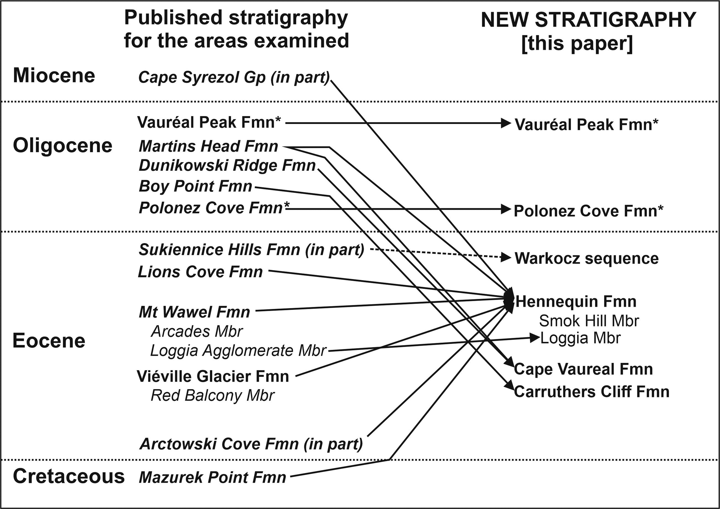
Fig. 14. Diagram summarizing the major differences between the published stratigraphies of the areas examined in this study and the new stratigraphy proposed here. A major feature of the new stratigraphy is the substantial reduction in the number of stratigraphical units now recognized, as well as the reassigned stratigraphical affinities of several units (mainly previously considered Oligocene). Note that outcrops of supposed Oligocene formations within the study areas (i.e. outliers of the Martins Head, Dunikowski Ridge and Boy Point formations) also crop out elsewhere, and it is only within the areas studied that their ages and stratigraphical affinities are reassigned. The Warkocz sequence is not a named stratigraphical unit and its correlation with similar-looking lithofacies exposed near Lions Rump (i.e. supposedly part of the Sukiennice Hills Formation) is tentative at present. The age of the Mazurek Point Formation was previously inferred to be Cretaceous to Oligocene. * = formations not discussed in this paper.
Early studies suggested that the age of volcanism at Point Hennequin ranged from 47 to 24 Ma (Fig. 3; Dupre Reference Dupre1982, Smellie et al. Reference Smellie, Pankhurst, Thomson and Davies1984, Birkenmajer et al. Reference Birkenmajer, Delitala, Narębski, Nicoletti and Petrucciani1986). Smellie et al. (Reference Smellie, Pankhurst, Thomson and Davies1984) suggested that the lithological similarity of geological units throughout the sequence was consistent with an Eocene age (47–44 Ma) for the entire section. This was supported by an unpublished 40Ar/39Ar age of 47 ± 2 Ma on a lava from the summit region by Dupre (Reference Dupre1982). However, Birkenmajer (Reference Birkenmajer1981) and Birkenmajer et al. (Reference Birkenmajer, Delitala, Narębski, Nicoletti and Petrucciani1986) used the presence of a much younger K-Ar age (24.5 ± 0.5 Ma) determined on a lava above the Loggia Member to substantiate the division of the sequence into two formations. Further dating, by Nawrocki et al. (Reference Nawrocki, Pańczyk and Williams2011), produced Eocene 40Ar/39Ar ages (46.7 ± 0.3 and 46.8 ± 0.3 Ma) and a U-Pb age (48.7 ± 0.6 Ma) for a lava within the upper sequence (presumed to be from the Viéville Formation, but our mapping shows that the sample location is above the Loggia Member). The Mount Wawel summit lava was also dated as 43.8 ± 0.3 Ma. The ages by Nawrocki et al. (Reference Nawrocki, Pańczyk and Williams2011) resemble those determined by Smellie et al. (Reference Smellie, Pankhurst, Thomson and Davies1984; by K-Ar) for lavas below the Loggia Member. They clearly refute the Late Oligocene K-Ar age determined by Birkenmajer et al. (Reference Birkenmajer, Delitala, Narębski, Nicoletti and Petrucciani1986) for the summit sequence and confirm the interpretation by Smellie et al. (Reference Smellie, Pankhurst, Thomson and Davies1984; see also Nawrocki et al. Reference Nawrocki, Pańczyk and Williams2011) that the entire sequence is Eocene in age.
For volcanic sequences in the Vauréal Peak area, a range of K-Ar ages (47.0–17.3 Ma) was published by Birkenmajer et al. (Reference Birkenmajer, Soliani and Kawashita1989; Fig. 6). The oldest unit identified, assigned to the Martins Head Formation (said to be c. 29.5 Ma from the age of its type area at Martins Head), comprised lavas on the foreshore between Cape Vauréal and Chabrier Rock. It yielded disparate ages of 33.4 ± 4.1 and 28.0 ± 3.1 Ma. Outcrops identified with the Oligocene Boy Point Formation yielded conflicting ages of 45.9 ± 0.7 and 17.3 ± 1.3 Ma. An age of 49.0 ± 5.5 Ma was obtained on a supposed intrusion at Puchalski Peak (here identified as a lava within an outcrop of the Carruthers Cliff Formation) draped by diamictites of the glacial Vauréal Peak Formation (Fig. 6). Finally, a clast within the Vauréal Peak Formation at another locality was dated as 47.0 ± 1.1 Ma.
Hennequin Formation: Our new results in combination with the ages published by Dupre (Reference Dupre1982) and Nawrocki et al. (Reference Nawrocki, Pańczyk and Williams2011) confirm beyond doubt an Early Eocene age for the entire Hennequin Formation in its type area. However, the widely variable published K-Ar ages can be ignored as only indicative. Additional ages that are suspect include the two younger 40Ar/39Ar ages of 43.8 ± 0.3 and 44.0 ± 11 Ma, which are regarded as outlier ages of uncertain significance and are probably less reliable, as well as the published and two new ages obtained on the Mount Wawel summit lavas; the latter have very high errors, which also makes them essentially only indicative. The remaining ages, which are regarded as the most reliable, have a relatively narrow range of 47 ± 2 to 49.8 ± 5.7 Ma and yield a mean of 48.8 ± 3.3 Ma for the eruptive age of the Hennequin Formation in its type area (late Ypresian-early Lutetian). This is also regarded as the age of the palaeofloras found in situ and in erratic clasts at Point Hennequin.
Warkocz: Only a single lava in the Warkocz outcrop was dated, and it yielded a disturbed spectrum. The relationship between the outcrop and the Hennequin Formation is uncertain because of the probable presence of strike-slip faulting beneath Wanda Glacier. The plateau and total gas ages (46.4 ± 1.7 and 49.4 ± 8.4 Ma, respectively) are statistically different, although within error, and additional Warkocz lavas need to be dated to remove the uncertainty. Only an Eocene (Ypresian or Lutetian) age can be indicated at present.
Cape Vauréal Formation: This is a newly defined formation. The ages obtained on two samples (49 ± 2 and 50.9 ± 14.6 Ma) are within error, but the older age was determined on a sample with a very disturbed spectrum with probable excess Ar and a very high error. Conversely, the excellent Ar spectrum shown by the other sample suggests that its age may be more reliable (late Ypresian). The age is very close to and indistinguishable within error from that of the Hennequin Formation, but they differ significantly in composition (calc-alkaline (Hennequin) vs tholeiitic (Cape Vauréal)). The ages suggest that eruption of at least two different magma series might have overlapped on eastern King George Island. However, an erosional unconformity between the two formations is present at Vauréal Peak, implying a younger age for the Cape Vauréal Formation (Fig. 6), with a time break of unknown duration. This illustrates that further, more precise dating still needs to be undertaken on these sequences.
Carruthers Cliff Formation: The preferred age for this new formation is c. 52 Ma, which makes it potentially the oldest Eocene volcanic sequence dated in the study. Its age is similar to, but slightly younger than, the Early Eocene Fildes Formation at Fildes Peninsula (mainly c. 59–56 Ma; by K-Ar and 40Ar/39Ar; Smellie et al. Reference Smellie, Pankhurst, Thomson and Davies1984, Kraus Reference Kraus2005, Haase et al. Reference Haase, Beier, Fretzdorff, Smellie and Garbe-Schönberg2012, Gao et al. Reference Gao, Zhao, Yang, Liu, Liu, Zhang and Pei2018). Volcanic strata on Keller Peninsula also yielded ages of 62.1–43.6 Ma (by U-Pb and 40Ar/39Ar; Nawrocki et al. Reference Nawrocki, Pańczyk, Wójcik and Kozłowska-Roman2021), and ages of 53–51 Ma were obtained on Eocene strata near Demay Point (by K-Ar, U-Pb and 40Ar/39Ar; Nawrocki et al. Reference Nawrocki, Pańczyk and Williams2010, Reference Nawrocki, Pańczyk and Williams2011, Mozer et al. Reference Mozer, Pécskay and Krajewski2015). Thus, apart from a very few unconfirmed Late Cretaceous ages obtained on isolated volcanic outcrops with unknown affinities (e.g. Nawrocki et al. Reference Nawrocki, Pańczyk and Williams2011, Reference Nawrocki, Pańczyk, Wójcik and Kozłowska-Roman2021), the Carruthers Cliff Formation is one of the oldest volcanic units on King George Island. The composition of the Carruthers Cliff Formation is also tholeiitic, like the Cape Vauréal Formation, an attribute used to place both formations within the Penderecki Glacier Group (new stratigraphical unit). Broadly similar tholeiitic compositions are also characteristic of most of the volcanic units on western King George Island, but they are rare on eastern King George Island (Smellie et al. Reference Smellie, Pankhurst, Thomson and Davies1984, and unpublished data of JLS). The age of the deformation affecting the Carruthers Cliff Formation is unknown. Broadly coeval tilting of beds in the basal Keller Peninsula Formation on Keller Peninsula took place between 65 and 52 Ma, attributed to strike-slip activity on the Ezcurra Fault (Nawrocki et al. Reference Nawrocki, Pańczyk, Wójcik and Kozłowska-Roman2021), but it is unclear whether the Carruthers Cliff Formation deformation is related.
Other outcrops of the Hennequin Formation on King George Island
The refinement of the age and physical characteristics of the Hennequin Formation in its type area should make it easier to compare and contrast more precisely the geological histories of widely separated outcrops in the region and any constituent palaeofloras (e.g. Francis et al. Reference Francis, Ashworth, Cantrill, Crame, Howe, Stephens, Cooper, Barrett, Stagg, Storey and Stump2008, Cantrill & Poole Reference Cantrill and Poole2012). There are no additional outcrops of the Penderecki Glacier Group known on King George Island so far. However, volcanic sequences in the Demay Point-Red Hill area west of Admiralty Bay (Fig. 1), with ages of c. 53–51 Ma (Nawrocki et al. Reference Nawrocki, Pańczyk and Williams2010, Reference Nawrocki, Pańczyk and Williams2011, Mozer et al. Reference Mozer, Pécskay and Krajewski2015), also have tholeiitic compositions and may be correlatives of the Penderecki Glacier Group (Carruthers Cliff Formation?).
By contrast, lateral equivalents of the Hennequin Formation probably crop out widely on King George Island, as suggested by Smellie et al. (Reference Smellie, Pankhurst, Thomson and Davies1984). Correlatives are probably present on the west coast of Admiralty Bay between Sphinx Hill and Point Thomas (Fig. 15). They are dominated by thick (typically 15–20 m), often glassy andesite lavas with similar colonnade and entablature prismatic cooling joint patterns (several previously misidentified as intrusions; Birkenmajer Reference Birkenmajer1997b), calc-alkaline compositions and distinctive petrography. It is important to note that our map of Point Thomas (Fig. 15) is substantially dissimilar to that shown by Birkenmajer (Reference Birkenmajer1980) and the two maps cannot be easily reconciled. The lavas at Rescuers Hills are undated but are intruded by a rhyolite dyke at Sphinx Hill dated as 47.09 ± 0.56 Ma (by 40Ar/39Ar; Kraus Reference Kraus2005; Fig. 15). Rhyolites are very uncommon in the South Shetland Islands (Smellie et al. Reference Smellie, Pankhurst, Thomson and Davies1984), and it may be significant that the only other rhyolite currently known on King George Island is in the Hennequin Formation, at Red Balcony, although the Red Balcony rhyolite may be an altered andesite (see above). The proposed Hennequin Formation lavas at Point Thomas include two small inliers north of Dutkiewicz Cliff that are draped unconformably by thin, steep-dipping, mainly basaltic lavas (Smellie et al. Reference Smellie, Pankhurst, Thomson and Davies1984). Lavas of the overlying sequence (Point Thomas Formation of Birkenmajer Reference Birkenmajer1980) exposed in cliffs on the south side of Italia Valley are dated as 44.0 ± 1.3 and 44.6 ± 0.4 Ma (by 40Ar/39Ar; Nawrocki et al. Reference Nawrocki, Pańczyk and Williams2011; Fig. 15). They are significantly younger and more mafic than the Hennequin Formation at its type locality. Older ages of 52.3 ± 2.3 and 50.6 ± 1.2 Ma were obtained on the overlying lavas in Panorama Ridge by Dupre (Reference Dupre1982; also by 40Ar/39Ar), but the ages were obtained 40 years ago and their reliability is uncertain. With similar reasoning, although an age of 48.8 ± 0.8 Ma was obtained on a lava west of Rakusa Point that we correlate with the Hennequin Formation, the spectacularly columnar jointed Hennequin Formation lava at Jersak Hills (well-developed entablature; illustrated by Dupre Reference Dupre1982, fig. II-6) yielded a significantly younger age of 42.1 ± 0.8 Ma (Dupre Reference Dupre1982). Although it is difficult to judge the significance of these older ages, the Jersak Hills lava is pervasively glassy and is likely to have lost Ar, thus younging its apparent age. Dupre (Reference Dupre1982) also interpreted the Hennequin Formation outcrops north of Dutkiewicz Cliff as unconformably overlying the surrounding steeply dipping lavas. This is the converse of our interpretation but is an inferred relationship that was probably influenced by his isotopic ages. However, it is unable to explain why the surrounding relatively thin lavas show a broad radial distribution, dipping away from the outcrop of horizontal lavas (Fig. 15), a relationship that can also be interpreted as the steeply dipping lavas draping an older eroded landscape composed of horizontal Hennequin Formation lavas (as illustrated by Smellie et al. Reference Smellie, Pankhurst, Thomson and Davies1984, fig. 30).
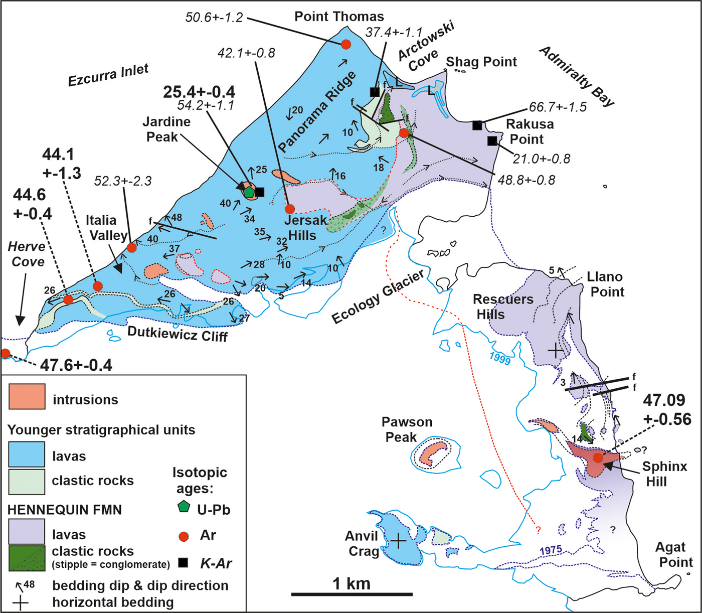
Fig. 15. Geological sketch map of volcanic outcrops on the west coast of Admiralty Bay and at Point Thomas, illustrating the distribution of likely Hennequin Formation strata (based on Smellie et al. Reference Smellie, Pankhurst, Thomson and Davies1984, and unpublished data of JLS and M.R.A. Thomson, 1975). The isotopic ages shown are from Dupre (Reference Dupre1982), Birkenmajer et al. (Reference Birkenmajer, Delitala, Narębski, Nicoletti and Petrucciani1986), Kraus (Reference Kraus2005), Panczyk et al. (Reference Pańczyk, Nawrocki and Williams2009) and Nawrocki et al. (Reference Nawrocki, Pańczyk and Williams2011). Ages shown in bold are thought to be the most reliable. Italicized ages in smaller font size are of uncertain significance and are probably less reliable (see text). Dashed lines indicate estimated dated sample locations. Dykes are unusually common at Point Thomas, and locally form swarms, but they are omitted for clarity. Also shown are ice limits for 1975 (on which the map is based) and for 1999, showing the remarkable reduction in the ice cover, which has reduced ice thickness by several tens of metres between the two years. Note that outcrops at Shag Point were regarded as a dyke by Kraus (Reference Kraus2005) but are reinterpreted here as a lava.
Other lava sequences on the south side of Ezcurra Inlet (at Platt Cliffs (Cytadela); Fig. 1) represent a lateral continuation of the various Point Thomas formations (Smellie et al. Reference Smellie, Pankhurst, Thomson and Davies1984, Mozer Reference Mozer2012, Reference Mozer2013). Two sequences are present: a lower sequence of thick (mainly ≥ 10 m) basaltic andesite and andesite lavas with prominent lathy plagioclase and prismatic pyroxene phenocrysts overlain by a sequence of much thinner (mainly c. 2–6 m) lavas in which prominent pyroxene phenocrysts are strongly anhedral (subrounded; unpublished data of JLS). Both sequences are currently regarded as members of the Point Thomas Formation (Mozer Reference Mozer2012, Reference Mozer2013). The lower sequence contains sedimentary rocks with wave ripples, small-scale cross-bedding and abundant angiosperm and gymnosperm plant fossils. Lavas in the lower sequence at Breccia Crag have ages of 47.6 ± 0.4 and 48.1 ± 0.2 Ma (by 40Ar/39Ar; 48.9 ± 0.7 Ma by U-Pb; Nawrocki et al. Reference Nawrocki, Pańczyk and Williams2011); ages of 45.4–28.6 Ma published by Birkenmajer et al. (Reference Birkenmajer, Gaździcki and Krajewski2005; by K-Ar), also probably from the lower sequence at the same locality, are widely variable and less reliable and only confirm an Eocene age. Conversely, the upper sequence is characterized by relatively thin undated basalt lavas, many with red boles, lacking conspicuous cooling joints. The characteristics and ages of the lower sequence are remarkably similar to those of the Hennequin Formation, whereas the upper sequence closely resembles lavas in the younger Point Thomas Formation; a less probable correlation of the latter, in view of the age difference, is with lavas of the Smok Hill Member of the Hennequin Formation. Any correlations with the Platt Cliffs sequences are speculative at this stage, however, and require validation by geochemical and further isotopic dating studies.
Outliers that correspond to the Hennequin Formation also occur south and west of Lions Rump (Fig. 16). Birkenmajer (Reference Birkenmajer1982) assigned the lavas to his ‘basaltic’ (mainly andesitic) Mazurek Point Formation, supposedly with an uncommonly wide-ranging Cretaceous-Oligocene age (c. 74–33 Ma). However, remarkably consistent 40Ar/39Ar plateau ages of 44.8 ± 0.2 and 44.7 ± 0.3 Ma were obtained on the lavas at Battke Point and Godwin Cliffs, respectively, and an age of 44.5 ± 0.3 Ma was obtained for an outcrop on the coast east of Magda Nunatak (Polish Geological Survey Cliffs; Fig. 1; Pańczyk & Nawrocki Reference Pańczyk and Nawrocki2011), indicating an Eocene (Lutetian) age similar to the 42 ± 1 Ma age obtained at Battke Point by Smellie et al. (Reference Smellie, Pankhurst, Thomson and Davies1984; by K-Ar). All three outcrops are thick andesite lavas showing well-developed columnar jointing (both colonnade and entablature). Despite the slight age difference, they are in every other characteristic indistinguishable from the Hennequin Formation, to which they are assigned here (see also Smellie et al. Reference Smellie, Pankhurst, Thomson and Davies1984). Outcrops at Lions Rump itself and to the south-west were previously assigned to the Lions Cove Formation and Sukiennice Hills Formation of the Polonia Glacier Group by Birkenmajer (Reference Birkenmajer1994) and inferred to be of Middle Eocene age, although undated. The rocks consist of: 1) essentially horizontal, thick andesite lavas and thin sedimentary interbeds at Lions Rump - the sediments contain poorly preserved plant leaves, permineralized wood and coaly lenses, including thin brown coals (Lions Cove Formation; see also Mozer Reference Mozer2013); and 2) thin andesite lavas, a spectacular, thick (30 m), coarse channel-based boulder conglomerate at Conglomerate Bluff and distinctive green ignimbrites with abundant flattened fiammé in the low hummocky ground west-south-west of Lions Rump, mainly at Emerald Crag and dipping at c. 20° to the south (part of the Suckiennice Hills Formation; Birkenmajer Reference Birkenmajer1981, Reference Birkenmajer1994, and unpublished data of JLS; Fig. 16). The ignimbrites are remarkably crumbly, and on that basis Barton (Reference Barton1965) assigned them a Pleistocene-Recent age. Based on the remarkable lithofacies similarities, the Lions Cove Formation in its entirety is here reassigned to the Hennequin Formation, whereas the conglomerate at Conglomerate Bluff, the ignimbrites at Emerald Crag and an associated interbedded thin lava are provisionally correlated with the lithologically similar sequence at Warkocz. From the very different bedding orientations, the two sequences at Lions Rump must be separated by an unexposed erosional unconformity (Fig. 16). Elsewhere in the Lions Rump-Low Head area, Eocene outcrops also occur on the coast at Polonez Cove, Low Head and Wesele Cove (Fig. 16). They are composed of thin basalt lavas 2–7 m thick with prominent autobreccias, some oxidized, and they are provisionally correlated with the Smok Hill Member.
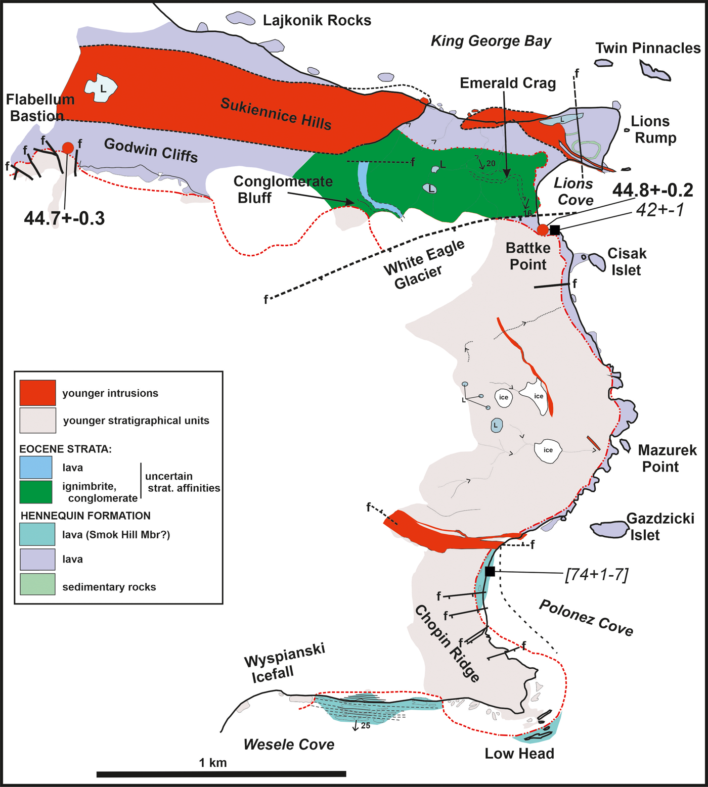
Fig. 16. Geological map of Lions Rump-Low Head showing the distribution of Eocene formations (based on J.L. Smellie, unpublished data, 1975 and 1995). Note that columnar jointed outcrops at Lajkonik Rocks and Cisak Islet, together with others at Polish Geological Survey Cliffs, Turret Point and Three Sisters Point (see Fig. 1 for locations), regarded as Early Miocene Cape Syrezol Group intrusive plugs (Birkenmajer Reference Birkenmajer1997b), are andesite lavas included in the Hennequin Formation, some of which have yielded Eocene isotopic ages (Pańczyk & Nawrocki Reference Pańczyk and Nawrocki2011). Ages shown in bold are by 40Ar/39Ar; italicized ages are by K-Ar (Smellie et al. Reference Smellie, Pankhurst, Thomson and Davies1984, Birkenmajer Reference Birkenmajer2001, Pańczyk & Nawrocki Reference Pańczyk and Nawrocki2011).
Additional localities provisionally correlated with the Hennequin Formation by Smellie et al. (Reference Smellie, Pankhurst, Thomson and Davies1984) include outcrops at Three Sisters Point and Turret Point; the north coast of Martel Inlet between Keller Peninsula and Precious Peaks; Admiralen and Komandor peaks; Wegger Peak; and the north coast of King George Island between Bolinder Bluff and Brimstone Peak (Fig. 1). The outcrops are described by Tokarski et al. (Reference Tokarski, Paolo and Rubinowski1981), Paulo & Tokarski (Reference Paulo and Tokarski1982), Birkenmajer (Reference Birkenmajer1997a) and Nawrocki et al. (Reference Nawrocki, Pańczyk, Wójcik and Kozłowska-Roman2021). Their stratigraphical assignation is tentative and based mainly on petrographical and compositional similarities with lavas of the Hennequin Formation. However, andesite lavas at Admiralen and Komandor peaks also have a single K-Ar age of 43.7 ± 4.8 Ma (Middle Eocene (Lutetian), perhaps slightly younged; Smellie et al. Reference Smellie, Pankhurst, Thomson and Davies1984, Birkenmajer et al. Reference Birkenmajer, Delitala, Narębski, Nicoletti and Petrucciani1986, Kraus Reference Kraus2005). By contrast, andesites at Turret Point and Three Sisters Point yielded significantly younger 40Ar/39Ar plateau ages of 37.3 ± 0.4 and 33.35 ± 0.15 to 29.1 ± 0.2 Ma (Late Eocene (Priabonian); Pańczyk & Nawrocki Reference Pańczyk and Nawrocki2011), comparable with a K-Ar age of 32 ± 1 Ma for an andesite from Esther Nunatak (Fig. 1; Smellie et al. Reference Smellie, Pankhurst, Thomson and Davies1984). As described above, Eocene ages (Lutetian) also occur for outcrops in the Lions Rump-Godwin Cliffs area. The reasons for the significantly younger ages compared with Hennequin Formation outcrops in the type area at Point Hennequin are unknown. Either the eastern outcrops are part of a different yet lithologically identical formation or the Hennequin Formation was very long-lived. Alternatively, the young ages are suspect. Such a long lifetime (c. 47–35 Ma) is unlikely to occur within a single volcanic edifice. It is notable that the ages become progressively younger in an easterly direction, which is broadly consistent with the age migration already identified on the island (Smellie Reference Smellie, Smellie, Panter and Geyer2021). We therefore favour an interpretation involving eruption from multiple centres (at least three?) with peaks in activity at c. 49, 45 and 35 Ma and a combined lifespan of ≥ 14 m.y. Time gaps probably intervened between the construction of the different centres.
Several of the other outcrops are pervasively altered, and unambiguous observations of the lithofacies are not yet available (e.g. north coast of King George Island and Martel Inlet between Wegger Peak and Precious Peaks; Smellie et al. Reference Smellie, Pankhurst, Thomson and Davies1984, Birkenmajer Reference Birkenmajer1997a), so their inclusion in the Hennequin Formation is unverified. However, andesite dykes on Keller Peninsula gave K-Ar ages of 44 ± 1 to 41 ± 1 Ma (Smellie et al. Reference Smellie, Pankhurst, Thomson and Davies1984), implying an older age for the volcanic host strata. This was confirmed by recent dating (ages of 48.73 ± 0.50 to 43.59 ± 0.77 Ma for lavas in the youngest unit present (Domeyko Glacier Formation); ages by 40Ar/39Ar and U-Pb; Nawrocki et al. Reference Nawrocki, Pańczyk, Wójcik and Kozłowska-Roman2021). The Domeyko Glacier Formation mainly consists of relatively thick andesite lavas (typically 10–20 m and up to 30 m thick), and it also crops out at the base of Ullmann Spur and Precious Peaks (Birkenmajer Reference Birkenmajer2001). Although the published lithological and petrographical details of sequences at Keller Peninsula and east to Precious Peaks are insufficient to confirm unambiguously a correlation with the Hennequin Formation, the available information suggests that the Domeyko Glacier Formation is probably a correlative.
Similar sequences of thick andesite lavas crop out at Admiralen Peak and Komandor Peak (and possibly near Wegger Peak) and are associated with a poor palaeoflora and fossil wood. They are currently regarded as the type sections for the Admiralen Peak and Znosko Glacier formations, respectively, with supposed Early Cretaceous to Palaeocene ages (by K-Ar; Birkenmajer Reference Birkenmajer2001). The possible presence of numerous trace fossils interpreted as crab burrows at Admiralen Peak suggests a possible marine influence (Birkenmajer Reference Birkenmajer2001). Trace fossils also occur in the Dragon Glacier plant beds but they are believed to be in fluvial and lacustrine deposits, although the identification of the Admiralen Peak ichnofossils as crab burrows may have been mistaken. However, with a published age of 43.7 ± 4.8 Ma for Admiralen Peak (by K-Ar; Birkenmajer Reference Birkenmajer2001) together with the distinctive lithological features, a correlation of the sequences at both localities with the Hennequin Formation may be more plausible. Finally, 40Ar/39Ar ages varying from 52.4 ± 1.1 to 41.9 ± 1.8 Ma have been published for several of the headlands on the north coast of the island (Shiling et al. Reference Shiling, Xiangshen, Molan and Birkenmajer1996), confirming how geographically widespread Eocene volcanism is, some of which is likely to be correlative with the Hennequin Formation (Smellie et al. Reference Smellie, Pankhurst, Thomson and Davies1984).
Preliminary palaeoenvironmental observations
Penderecki Glacier Group (c. 52–49 Ma): The age of the Penderecki Glacier Group coincides with the Early Eocene Climatic Optimum, a well-defined period of maximum global temperature causally linked to high atmospheric CO2 levels at c. 52–50 Ma, although it may have had a shorter duration of ≤ 1 m.y. (e.g. Hyland & Sheldon Reference Hyland and Sheldon2013). The basal lava in the Carruthers Cliff Formation has a suppressed basal colonnade and an expanded entablature consistent with flooding of the lava by surface water (cf. Long & Wood Reference Long and Wood1986). The lavas overlie several tens of metres of mainly diamictites with lesser conglomerates and sandstones. They were probably deposited from a series of mass flows, including debris flows, a spectacular debris avalanche deposit (our Carruthers Cliff local unit 3; Fig. 11), hyperconcentrated flows and lesser traction currents in a high-gradient fluvial setting subject to significant flooding episodes. Local unit 3, characterized by numerous lava mega-blocks, probably formed during a catastrophic, gravity-driven collapse event on a steep volcano flank. The pervasive jigsaw fracturing of the lava mega-blocks probably indicates incipient fragmentation of the blocks during transport. Additionally, the presence of ill-defined masses of conglomerate in the deposit, and also in local unit 1 diamictite, may indicate disruption, fragmentation and incorporation of a weak sedimentary substrate by the moving mass of debris.
The basal sediments (i.e. Carruthers Cliff plant beds) also include a depauperate palaeoflora indicating a Nothofagus and fern forest with conifers absent. From our preliminary assessment, the leaf assemblage bears a limited resemblance to floras elsewhere on King George Island, at Cytadela (Platt Cliffs; Fig. 1) and Point Hennequin (cf. Birkenmajer & Zastawniak Reference Birkenmajer, Soliani and Kawashita1989, Hunt & Poole Reference Hunt and Poole2003, Fontes & Dutra Reference Fontes and Dutra2010, Mozer Reference Mozer2012), but the overall dissimilarities suggest that they originated from different initial vegetation types. In combination with the wood fragments, which have not been examined, the Carruthers Cliff flora suggests a successional vegetation following increasingly active volcanism, otherwise there would be a more diverse climax vegetation. It is possibly a pioneer vegetation type, which probably reflects environmental disturbance caused by the volcanism (cf. Cantrill & Poole Reference Cantrill and Poole2012). The likelihood is thus increased that the diversity seen in other palaeofloras in the region may also be strongly influenced by environmental conditions rather than simply changes in climate, as is generally assumed.
The Cape Vauréal Formation is dominated by crystalline lavas, some of which show poorly exposed, thin, oxidized autobreccias consistent with subaerial effusion in an essentially dry setting. However, one of the Cape Vauréal Formation lavas at Rembiszewski Nunataks is cut by a probable hydrovolcanic breccia (Fig. 7), attesting to wet substrate conditions and localized bulk interaction steam explosivity during emplacement of the lava. The lavas in the formation show no other obvious evidence for interaction with water, but at Harnasie Hill they are interbedded with conglomerates and mud-rich polymict diamictite with numerous flattened juvenile lapilli. The association of lithofacies suggests wet, possibly fluvial conditions at times and local flooding events that included debris flow deposition perhaps linked to phreatomagmatic eruptions.
Hennequin Formation (mainly c. 49–45 Ma, possibly extending to c. 35 Ma): The characteristics of sedimentary units in the Hennequin Formation and associated sedimentary erratics suggest that they are lacustrine, lahar and fluvial deposits (cf. Hunt & Poole Reference Hunt and Poole2003, Fontes & Dutra Reference Fontes and Dutra2010, Uchman et al. Reference Uchman, Gaździcki and Błażejowski2018). They have a strong pyroclastic component, including as ash-fall, and they have been assigned a variety of fluvio-lacustrine depositional environments situated on the lower flanks of a local central volcano (Hunt & Poole Reference Hunt and Poole2003). Fontes & Dutra (Reference Fontes and Dutra2010) interpreted the volcanic input to the succession at the snout of Dragon Glacier mainly in terms of ash-fall and surge deposits, and the low vesicularity and high fragmentation of the juvenile particles suggest a predominantly hydrovolcanic origin generally (Hunt & Poole Reference Hunt and Poole2003). Several lavas in the Hennequin Formation also show conspicuous evidence, in the form of cooling joint patterns, for flooding of their surfaces by water, perhaps when the lavas blocked river channels. Moreover, the Loggia Member is dominated by massive coarse clastic beds, predominantly diamictites and lesser breccio-conglomerates mainly emplaced as debris flows. They are associated with pervasively fractured lavas that suggest significant interaction with coeval surface water or wet sediments, at least in part. The source of the water affecting lavas and pyroclastic rocks in the Hennequin Formation is unknown, but eruptions took place in the cooler period following the Early Eocene Climatic Optimum. At least some of these eruptions might therefore have been associated with eruption-induced melting of one or more summit ice caps (cf. Birkenmajer et al. Reference Birkenmajer, Gaździcki and Krajewski2005; Mozer Reference Mozer2012). Thus, for example, the water-cooled lavas in the Loggia Member might be long run-out lava flows generated during subglacial eruptions but that, together with the associated diamicts and breccio-conglomerates (cf. jökulhlaup deposits), were ultimately deposited beyond the limits of any ice cap(s).
The presence of Eocene ice in Antarctica is supported by numerous studies, although the ages of potential ice episodes are poorly determined and the Eocene formations in our study pre-date those identified so far (see Carter et al. Reference Carter, Riley, Hillenbrand and Rittner2017 and references therein). Hunt & Poole (Reference Hunt and Poole2003) used morphological leaf indices and leaf sizes to estimate mean annual temperature (MAT) and mean annual precipitation (MAP) values for palaeofloras in the most diverse Dragon Glacier flora at Point Hennequin. Their results suggested a MAT of c. 10–11°C (Fontes & Dutra Reference Fontes and Dutra2010, estimated 12–13°C), closely comparable with values derived from the Late Palaeogene-Early Eocene in the James Ross Basin (Ditchfield et al. Reference Ditchfield, Marshall and Pirrie1994, Francis & Poole Reference Francis and Poole2002). They also estimated a MAP of c. 1039 (+449, -313) mm (or possibly 950 mm: Fontes & Dutra Reference Fontes and Dutra2010). The conditions are cool and wet enough to enable summit ice caps to form on volcanic edifices > 1000 m high, a not unusual height for large central volcanoes.
Possible support for an Eocene ice cap associated with the Hennequin Formation comes from the lower lava sequence on the south side of Ezcurra Inlet, which is here tentatively correlated with the Hennequin Formation (see above). Birkenmajer et al. (Reference Birkenmajer, Gaździcki and Krajewski2005) suggested that a diamictite within the Ezcurra Inlet sequence was a glacial deposit, which he informally named the Hervé Cove tillite. However, the nature of the erratics mentioned in that deposit was not described, nor was it described by subsequent workers (e.g. Mozer Reference Mozer2012, Reference Mozer2013). Moreover, the same unit was previously described merely as a lahar deposit (Birkenmajer et al. Reference Birkenmajer, Gradziński and Porębski2002). Lahars are triggered by loss of stability of a water-saturated regolith, and, together with debris avalanches, they are common on stratovolcanoes where the steep flanks and rapid accumulation of lavas and friable volcaniclastic deposits promote gravitational instability. Melting of a summit ice cap is thus not a necessary precondition, and the interpretation of the Hervé Cove diamictite as a tillite is currently unproven.
Our dating of the entire sequence at Point Hennequin as Eocene in age (see also Nawrocki et al. Reference Nawrocki, Pańczyk and Williams2011) removes all evidence for an interglacial episode occurring on King George Island at 32–28 Ma (Oligocene), as suggested by Birkenmajer et al. (Reference Birkenmajer, Narębski, Nicoletti and Petrucciani1983). This will have consequences for a better understanding of the evolution of Palaeogene-Neogene floras (cf. Birkenmajer & Zastawniak Reference Birkenmajer, Soliani and Kawashita1989, Dutra & Batten Reference Dutra and Batten2000, Poole et al. Reference Poole, Hunt and Cantrill2001, Hunt & Poole Reference Hunt and Poole2003, Francis et al. Reference Francis, Ashworth, Cantrill, Crame, Howe, Stephens, Cooper, Barrett, Stagg, Storey and Stump2008, Fontes & Dutra Reference Fontes and Dutra2010, Cantrill & Poole Reference Cantrill and Poole2012, Mozer Reference Mozer2012, Reference Mozer2013, Reference Mozer, Pécskay and Krajewski2015).
Finally, the ignimbrites in the Warkocz and Emerald Crags sequences are dominated by broken fragments of tube pumice but vary to lithic-rich deposits essentially indistinguishable from diamictites seen elsewhere in other Eocene sequences. This combination of features might be due to an unusual mode of formation, speculatively perhaps as ignimbrites initially deposited on snow or ice, with subsequent remobilization and redeposition (with incorporation of locally derived materials) following volcanothermally induced melting of the snow/ice substrate.
Conclusions
A succession of at least four discrete stratigraphical volcanic units dominates outcrops between Point Hennequin and Vauréal Peak and much of eastern King George Island. The volcanic sequences were formerly thought to range in age from Early Eocene to Late Oligocene, mainly on the basis of ages derived by the K-Ar method. However, new and recently published 40Ar/39Ar ages indicate that they are Early Eocene (mainly Ypresian) in age. They are assigned to the Hennequin Formation (48.8 ± 3.3 Ma in its type area) and a new group composed of two new formations (Cape Vauréal and Carruthers Cliff formations) collectively called the Penderecki Glacier Group (52–49 Ma). A fourth Eocene sequence, cropping out at Warkocz and south-west of Lions Rump, contains the only prominent ignimbrite units encountered. It may be a different stratigraphical unit, but its distribution and overall characteristics are still poorly known. The other three sequences are dominated by lavas with lesser sedimentary and volcaniclastic rocks. The Hennequin Formation is calc-alkaline, whereas the Penderecki Glacier Group is tholeiitic. The Hennequin Formation is composed of lavas with relatively silicic basaltic andesite and (particularly) andesite compositions, whereas lavas in the Penderecki Glacier Group are mainly basaltic with fewer basaltic andesites. The Carruthers Cliff Formation contains a relatively depauperate Nothofagus-dominated fossil flora, comprising leaves and wood. The outcrop extent of the Penderecki Glacier Group currently appears to be restricted to near Vauréal Peak and possibly Demay Point-Red Hill, whereas our study suggests that correlatives of the Hennequin Formation are much more widespread, particularly on eastern King George Island, where they may extend to significantly younger ages. Abundant evidence for wet conditions is present in all of the Eocene sequences, including frequent flooding episodes and likely explosive hydrovolcanic eruptions that may have involved local ice caps. Although evidence for Eocene ice on King George Island is mounting, it remains speculative and inconclusive, and its presence is not yet convincingly established.
Acknowledgements
The authors are very grateful to the British Antarctic Survey and the University of Leeds for their support of this investigation. We are also grateful for the help of Andy Teasdale and Ash Morton during fieldwork on King George Island. Professors D.J. Cantrill and J. Francis and Dr Imogen Poole are thanked for their discussions during the palaeobotanical study, and Phil Guise is thanked for his help and guidance with the geochronology at the University of Leeds. We are very grateful to Dr M.R.A. Thomson (deceased) for the provision of information used in the map of the geology of Point Thomas. The authors also gratefully thank the captains, officers and crews of HMS Endurance for their invaluable logistical support. Mike Tabecki (British Antarctic Survey) is also thanked for making the numerous thin sections from often challenging samples that were used in this study. Drs Jerzy Nawrocki and Anna Mozer are also thanked for their careful reviews of our paper, which helped to improve it. Finally, Ieuan Hopkins and Kevin Roberts of the British Antarctic Survey Archive Service are thanked for helping with access to archived field data.
Author contributions
JLS: conceptualization (lead), data acquisition (equal), data curation (equal), formal analysis (lead), funding acquisition (lead), investigation (lead), writing - original draft (lead), writing - review and editing (lead).
RJH: conceptualization (supporting), data acquisition (equal), data curation (equal), formal analysis (equal), investigation (equal), writing - original draft (supporting), writing - review and editing (equal).
WCM: conceptualization (supporting), data acquisition (supporting), data curation (equal), formal analysis (supporting), investigation (supporting), writing - original draft (supporting), writing - review and editing (supporting).
RPE: conceptualization (supporting), data acquisition (equal), data curation (equal), formal analysis (supporting), investigation (supporting), writing - original draft (supporting), writing - review and editing (supporting).
Supplemental material
Three supplemental information files will be found at https://doi.org/10.1017/S0954102021000213.


 Open access