
The Importance of Environmental Factors for the Development of Water Erosion of Soil in Agricultural Land: The Southern Part of Hronská Pahorkatina Hill Land, Slovakia


Abstract
:
1. Introduction
1.1. Environmental Factors Supporting the Development of Erosion
1.1.1. Primary Factors
1.1.2. Secondary Factors
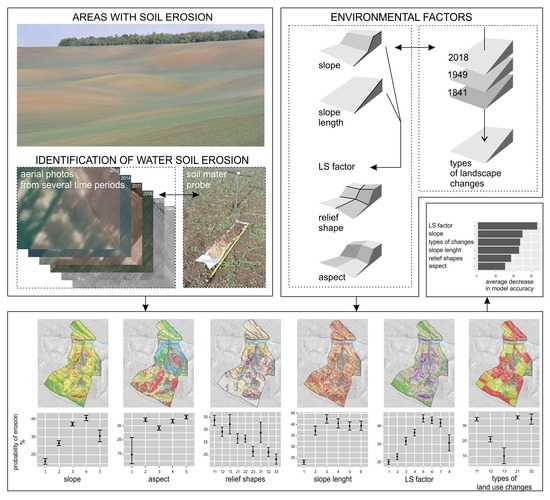
2. Materials and Methods
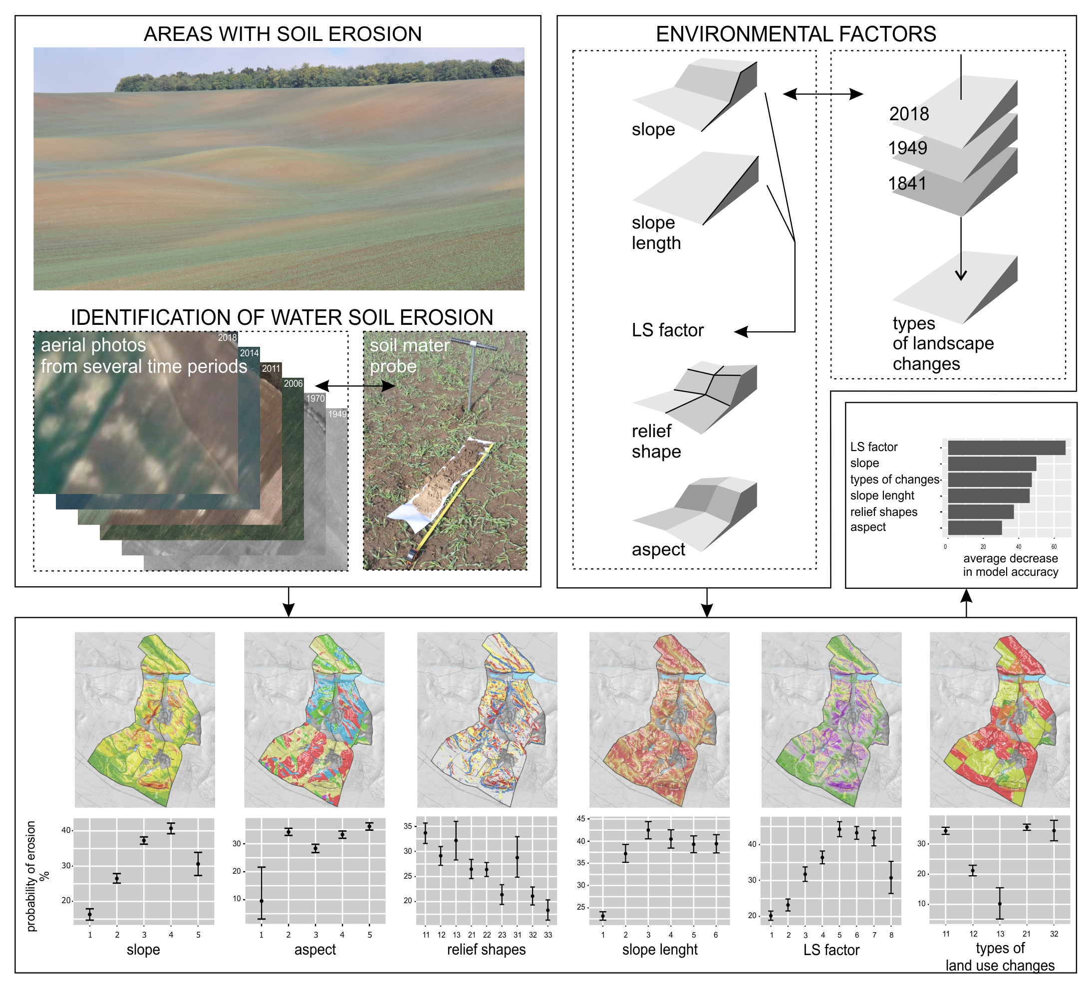
2.1. Study Area
2.2. Evaluation of Erosion Factors
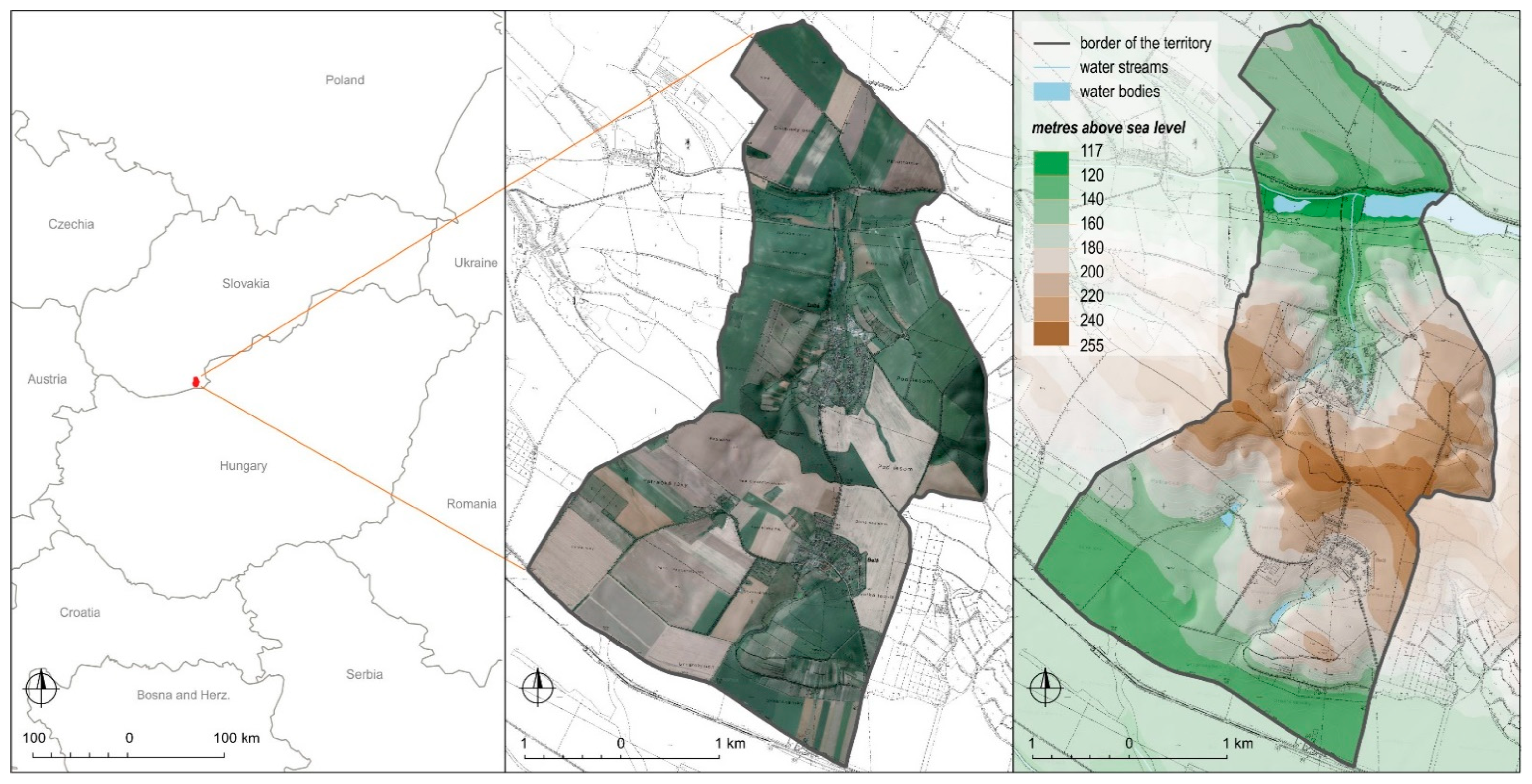
2.2.1. Areas Threatened by Water Erosion
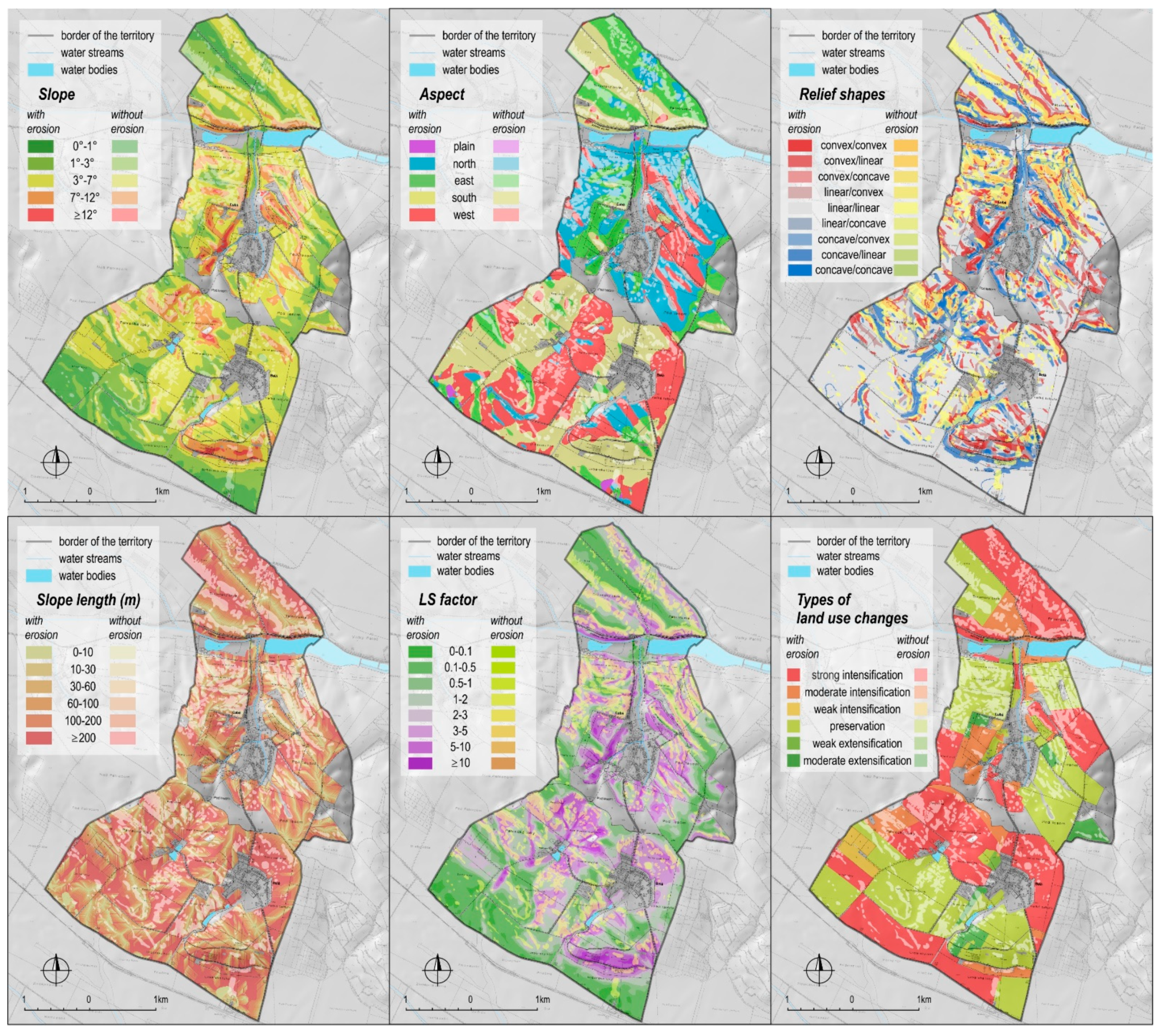
2.2.2. Selected Properties of the Relief
2.2.3. Types of Land Use Change
2.2.4. Significance of the Erosion Factors
3. Results
3.1. Identification of the Spatial Distribution of Water Erosion
3.2. Evaluation of Factors
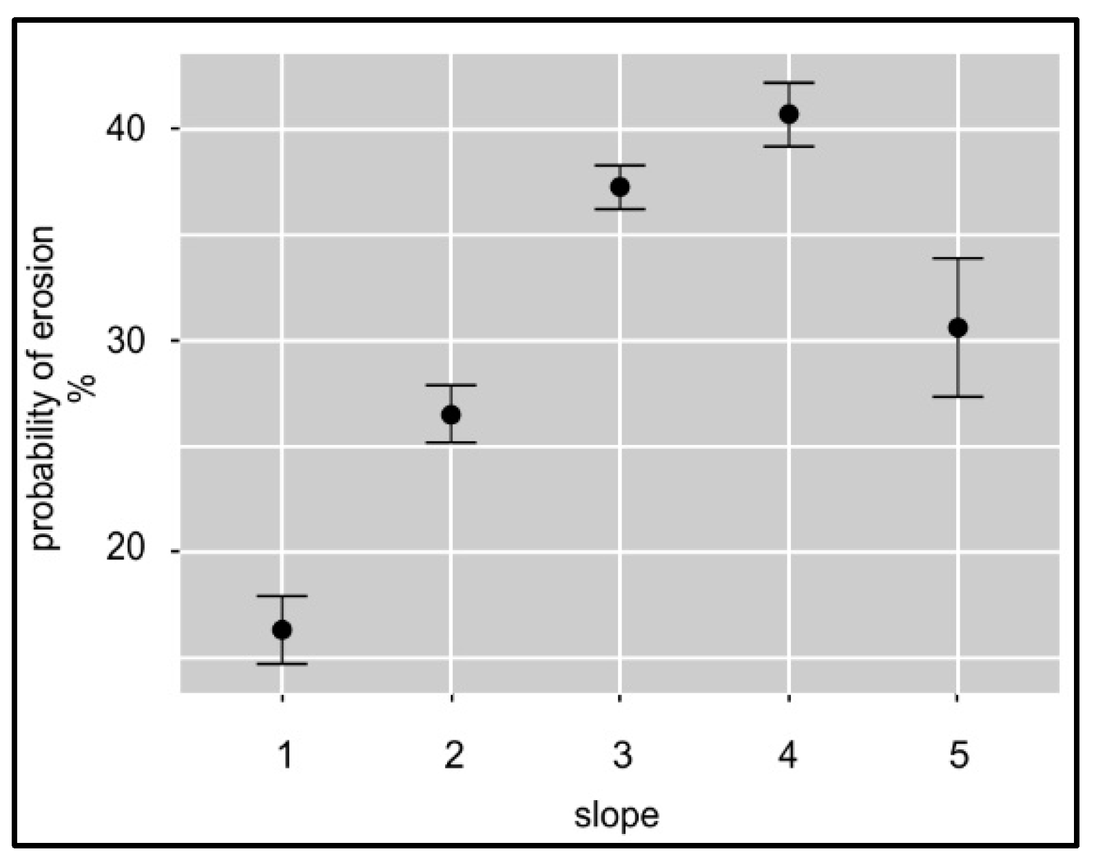
3.2.1. Slope
3.2.2. Aspect
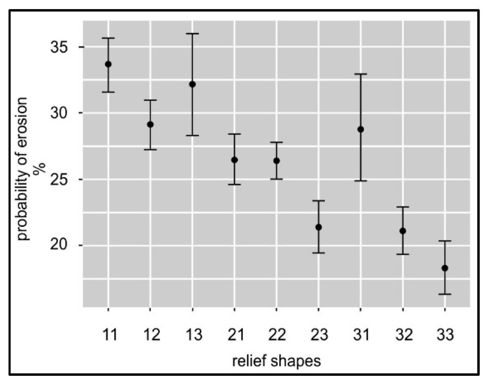
3.2.3. Relief Shapes
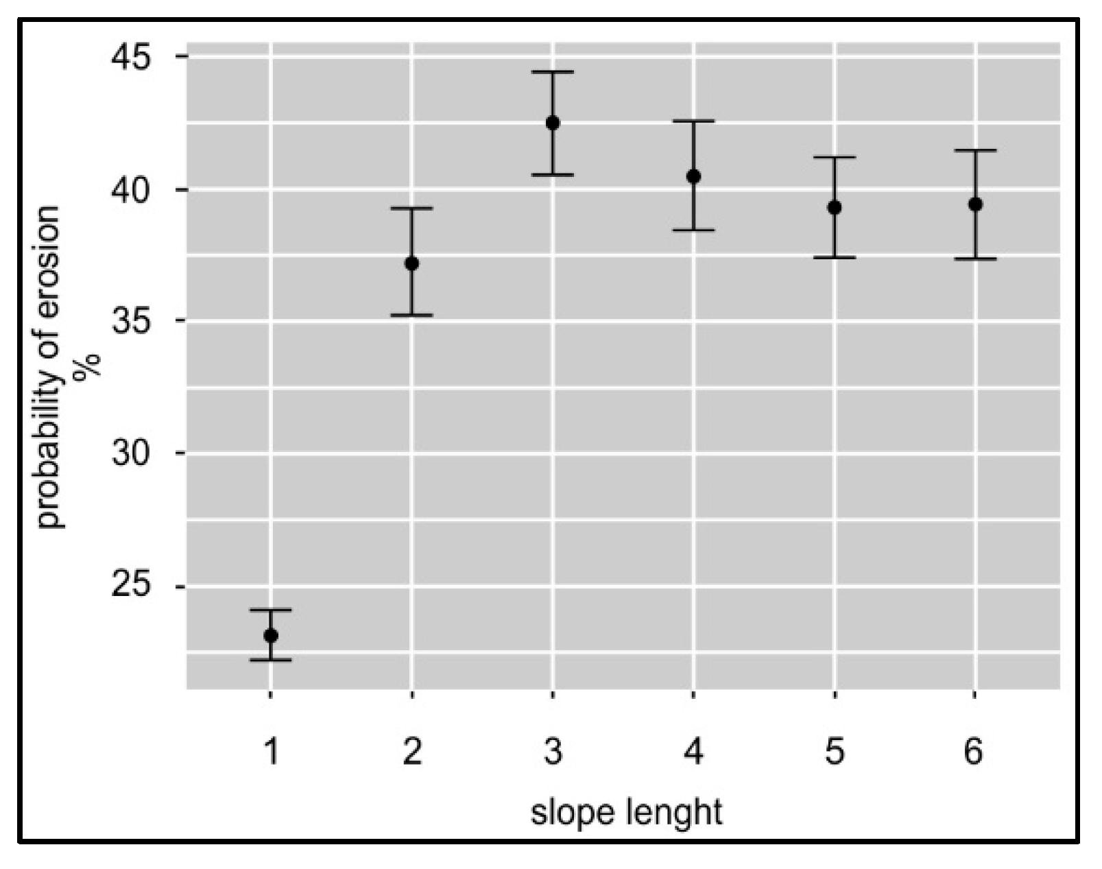
3.2.4. Slope Length
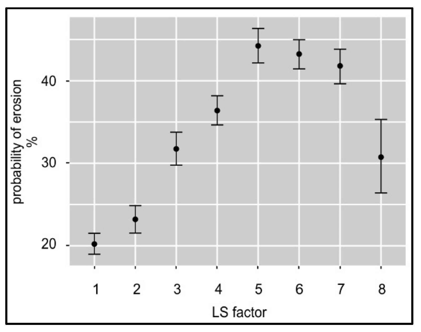
3.2.5. LS Factor
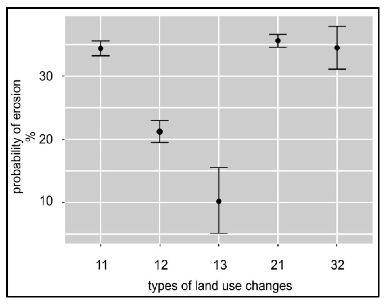
3.2.6. Types of Land Use Changes
3.3. Significance of Evaluated Erosion Factors in the Development of Water Erosion
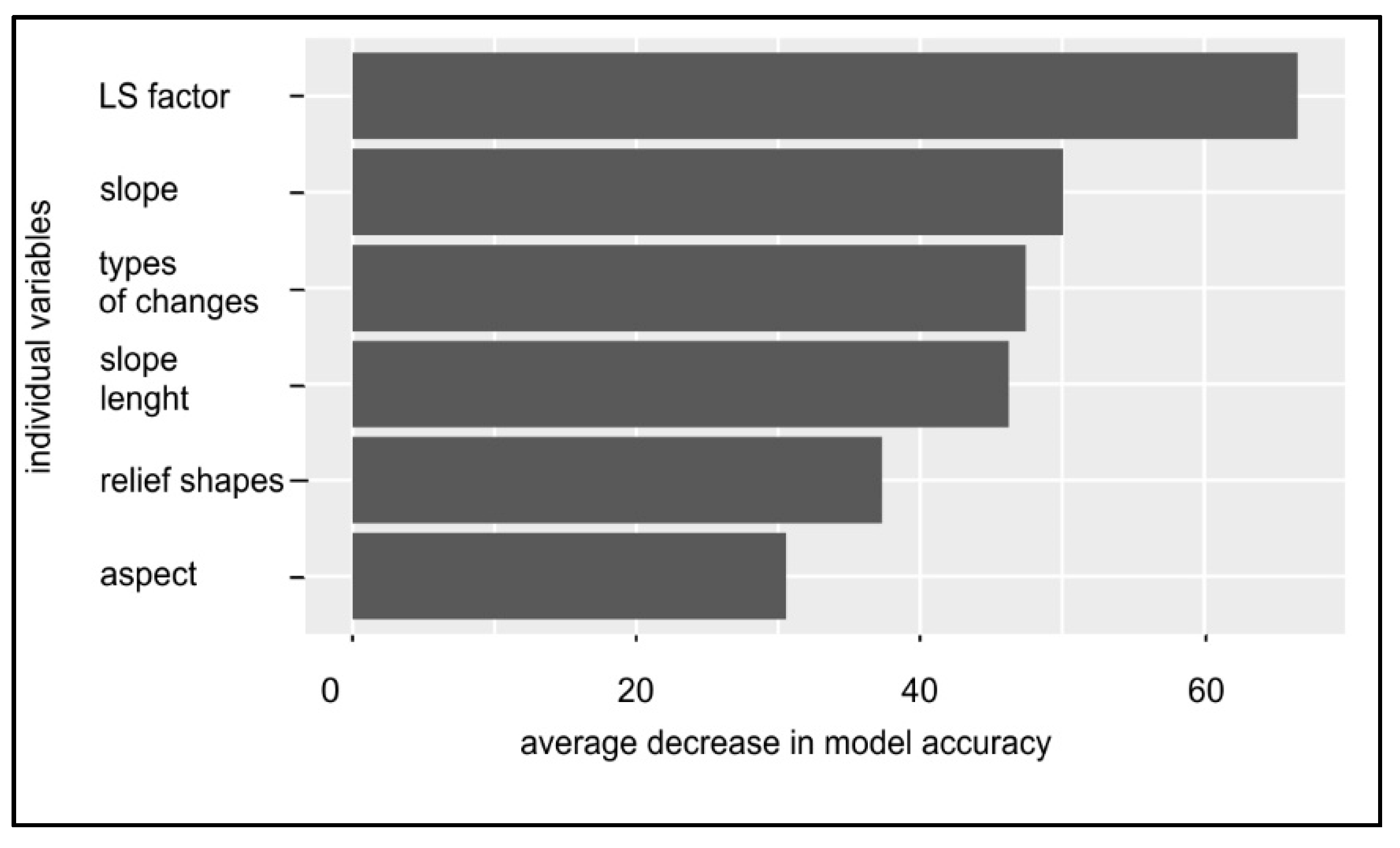
3.4. Estimation of the Significance of the Evaluated Factors
4. Discussion
5. Conclusions
Author Contributions
Funding
Institutional Review Board Statement
Informed Consent Statement
Data Availability Statement
Acknowledgments
Conflicts of Interest
References
- Lal, R. Soil Degradation by Erosion. Land Degrad. Dev. 2001, 12, 519–539. [Google Scholar] [CrossRef]
- Boardman, J.; Poesen, J. Soil Erosion in Europe; John Wiley & Sons: New York, NY, USA, 2007; ISBN 978-0-470-85911-7. [Google Scholar]
- Panagos, P.; Borrelli, P.; Poesen, J.; Ballabio, C.; Lugato, E.; Meusburger, K.; Montanarella, L.; Alewell, C. The New Assessment of Soil Loss by Water Erosion in Europe. Environ. Sci. Policy 2015, 54, 438–447. [Google Scholar] [CrossRef]
- Alewell, C.; Egli, M.; Meusburger, K. An Attempt to Estimate Tolerable Soil Erosion Rates by Matching Soil Formation with Denudation in Alpine Grasslands. J. Soils Sediments 2015, 15, 1383–1399. [Google Scholar] [CrossRef] [Green Version]
- Berhe, A.A.; Kleber, M. Erosion, Deposition, and the Persistence of Soil Organic Matter: Mechanistic Considerations and Problems with Terminology. Earth Surf. Process. Landf. 2013, 38, 908–912. [Google Scholar] [CrossRef]
- Stankoviansky, M. Historical Evolution of Permanent Gullies in the Myjava Hill Land, Slovakia. Catena 2003, 51, 223–239. [Google Scholar] [CrossRef]
- Wei, J.; Zhou, J.; Tian, J.; He, X.; Tang, K. Decoupling Soil Erosion and Human Activities on the Chinese Loess Plateau in the 20th Century. Catena 2006, 68, 10–15. [Google Scholar] [CrossRef]
- Fritz, S.; See, L.; Carlson, T.; Haklay, M.M.; Oliver, J.L.; Fraisl, D.; Mondardini, R.; Brocklehurst, M.; Shanley, L.A.; Schade, S.; et al. Citizen Science and the United Nations Sustainable Development Goals. Nat. Sustain. 2019, 2, 922–930. [Google Scholar] [CrossRef]
- Wischmeier, W.H.; Smith, D.D. Predicting Rainfall-Erosion Losses from Cropland East of the Rocky Mountains: Guide for Selection of Practices for Soil and Water Conservation; Agricultural Research Service, U.S. Department of Agriculture: Washington, DC, USA, 1965. [Google Scholar]
- Morgan, R.P.C. Soil Erosion and Conservation; John Wiley & Sons: New York, NY, USA, 2009; ISBN 978-1-4051-4467-4. [Google Scholar]
- Petlušová, V.; Petluš, P.; Hreško, J. Identifikácia Procesov Vodnej Erózie v Poľnohospodárskej Krajine, 1st ed.; Univerzita Konštantína Filozofa v Nitre: Nitra, Slovakia, 2016; ISBN 978-80-558-1118-5. [Google Scholar]
- Rodrigo-Comino, J.; Brevik, E.C.; Cerdà, A. The Age of Vines as a Controlling Factor of Soil Erosion Processes in Mediterranean Vineyards. Sci. Total Environ. 2018, 616–617, 1163–1173. [Google Scholar] [CrossRef] [PubMed] [Green Version]
- Gao, J.; Jiang, Y.; Wang, H.; Zuo, L. Identification of Dominant Factors Affecting Soil Erosion and Water Yield within Ecological Red Line Areas. Remote Sens. 2020, 12, 399. [Google Scholar] [CrossRef] [Green Version]
- Ahmed, A.; Nawaz, R.; Woulds, C.; Drake, F. Influence of Hydro-Climatic Factors on Future Coastal Land Susceptibility to Erosion in Bangladesh: A Geospatial Modelling Approach. J. Geovis. Spat. Anal. 2020, 4, 6. [Google Scholar] [CrossRef] [Green Version]
- Zhang, X.C.J.; Wang, Z.L. Interrill Soil Erosion Processes on Steep Slopes. J. Hydrol. 2017, 548, 652–664. [Google Scholar] [CrossRef]
- Rieke-Zapp, D.H.; Nearing, M.A. Slope Shape Effects on Erosion. Soil Sci. Soc. Am. J. 2005, 69, 1463–1471. [Google Scholar] [CrossRef]
- Assouline, S.; Ben-Hur, M. Effects of Rainfall Intensity and Slope Gradient on the Dynamics of Interrill Erosion during Soil Surface Sealing. Catena 2006, 66, 211–220. [Google Scholar] [CrossRef]
- Gray, D. Effect of Slope Shape on Soil Erosion. J. Civ. Environ. Eng. 2016, 6, 1–2. [Google Scholar] [CrossRef] [Green Version]
- Bagio, B.; Bertol, I.; Wolschick, N.H.; Schneiders, D.; Santos, M.A.D.N.D. Water Erosion in Different Slope Lengths on Bare Soil. Rev. Bras. Cienc. Solo 2017, 41. [Google Scholar] [CrossRef] [Green Version]
- Ma, B.; Liu, G.; Ma, F.; Li, Z.; Wu, F. Effects of Crop-Slope Interaction on Slope Runoff and Erosion in the Loess Plateau. Acta Agric. Scand. Sect. B Soil Plant Sci. 2019, 69, 12–25. [Google Scholar] [CrossRef]
- Zachar, D. Soil Erosion; Elsevier: Amsterdam, The Netherlands, 2011; ISBN 978-0-08-086977-3. [Google Scholar]
- Moore, I.D.; Wilson, J.P. Length-Slope Factors for the Revised Universal Soil Loss Equation: Simplified Method of Estimation. J. Soil Water Conserv. 1992, 47, 423–428. [Google Scholar]
- Chaplot, V.A.M.; Bissonnais, Y.L. Runoff Features for Interrill Erosion at Different Rainfall Intensities, Slope Lengths, and Gradients in an Agricultural Loessial Hillslope. Soil Sci. Soc. Am. J. 2003, 67, 844–851. [Google Scholar] [CrossRef]
- Liu, Y.; Xin, Y.; Xie, Y.; Wang, W. Effects of Slope and Rainfall Intensity on Runoff and Soil Erosion from Furrow Diking under Simulated Rainfall. Catena 2019, 177, 92–100. [Google Scholar] [CrossRef]
- Petrikovičová, L.; Rampašeková, Z.; Sobocká, J. A Detailed Identification of Erosionally Endangered Agricultural Land in Slovakia (Case Study of Nitra Upland). Sustainability 2020, 12, 4863. [Google Scholar] [CrossRef]
- Krcho, J. Morphometric Analysis of the Relief on the Basis of Geometrical Aspect of Field Theory. Acta Geogr. Univ. Comen. 1973, 11–233. [Google Scholar]
- Hurst, M.D.; Mudd, S.M.; Walcott, R.; Attal, M.; Yoo, K. Using Hilltop Curvature to Derive the Spatial Distribution of Erosion Rates. J. Geophys. Res. Earth Surf. 2012, 117, 1–19. [Google Scholar] [CrossRef] [Green Version]
- Ohlmacher, G.C. Plan Curvature and Landslide Probability in Regions Dominated by Earth Flows and Earth Slides. Eng. Geol. 2007, 91, 117–134. [Google Scholar] [CrossRef]
- Minár, J.; Evans, I.S. Elementary Forms for Land Surface Segmentation: The Theoretical Basis of Terrain Analysis and Geomorphological Mapping. Geomorphology 2008, 95, 236–259. [Google Scholar] [CrossRef]
- Fulajtár, E.; Janský, L. Vodná Erózia Pôdy a Protierózna Ochrana; VÚPOP: Bratislava, Slovakia, 2001. [Google Scholar]
- Hughes, P.J. Slope Aspect and Tunnel Erosion in the Loess of Banks Peninsula, New Zealand. J. Hydrol. N. Z. 1972, 11, 94–98. [Google Scholar]
- Hanna, A.Y.; Harlan, P.W.; Lewis, D.T. Soil Available Water as Influenced by Landscape Position and Aspect. Agron. J. 1982, 74, 999–1004. [Google Scholar] [CrossRef]
- Agassi, M.; Morin, J.; Shainberg, I. Slope, Aspect, and Phosphogypsum Effects on Runoff and Erosion. Soil Sci. Soc. Am. J. 1990, 54, 1102–1106. [Google Scholar] [CrossRef]
- Agassi, M.; Ben-Hur, M. Effect of Slope Length, Aspect and Phosphogypsum on Runoff and Erosion from Steep Slopes. Soil Res. 1991, 29, 197–207. [Google Scholar] [CrossRef]
- Igaz, D.; Bárek, V.; Halaj, P.; Takáč, J.; Čimo, J. A Comparison of Measured Soil Moisture with Simulated Results Obtained by Selected Models for Danubian Lowland. Cereal Res. Commun. 2008, 36, 1619–1622. [Google Scholar]
- Vanwalleghem, T.; Gómez, J.A.; Infante Amate, J.; González de Molina, M.; Vanderlinden, K.; Guzmán, G.; Laguna, A.; Giráldez, J.V. Impact of Historical Land Use and Soil Management Change on Soil Erosion and Agricultural Sustainability during the Anthropocene. Anthropocene 2017, 17, 13–29. [Google Scholar] [CrossRef]
- Špulerová, J.; Petrovič, F.; Mederly, P.; Mojses, M.; Izakovičová, Z. Contribution of Traditional Farming to Ecosystem Services Provision: Case Studies from Slovakia. Land 2018, 7, 74. [Google Scholar] [CrossRef] [Green Version]
- Muchová, Z.; Raškovič, V. Fragmentation of Land Ownership in Slovakia: Evolution, Context, Analysis and Possible Solutions. Land Use Policy 2020, 95, 104644. [Google Scholar] [CrossRef]
- Li, S. Landscape Integrated Soil and Water Conservation (LISWC) System for Sloping Landscapes in Atlantic Canada. Agriculture 2021, 11, 427. [Google Scholar] [CrossRef]
- Solín, Ľ.; Cebecauer, T. Vplyv kolektivizácie poľnohospodárstva na vodnú eróziu pôdy v povodí Jablonky. Geogr. Časopis 1998, 48, 153–170. [Google Scholar]
- Mazúr, E.; Lukniš, M. Geomorfologické Jednotky. In Atlas Slovenskej Socialistickej Republiky; SAV, Slovenský Úrad Geografie a Kartografie: Bratislava, Slovakia, 1980; pp. 54–55. ISBN 79-25-80. [Google Scholar]
- Tremboš, P.; Minár, J. Morfologicko-Morfometrické Typy Reliéfu. In Atlas Krajiny Slovenskej Republiky; MŽP SR, SAŽP: Banská Bystica, Slovakia, 2002; pp. 90–91. ISBN 80-88833-27-2. [Google Scholar]
- Čurlík, J.; Šály, R. Zrnitosť Pôdy. In Atlas Krajiny Slovenskej Republiky; MŽP SR, SAŽP: Banská Bystica, Slovakia, 2002; pp. 110–111. ISBN 80–88833–27–2. [Google Scholar]
- King, C.; Baghdadi, N.; Lecomte, V.; Cerdan, O. The Application of Remote-Sensing Data to Monitoring and Modelling of Soil Erosion. Catena 2005, 62, 79–93. [Google Scholar] [CrossRef]
- Vrieling, A. Satellite Remote Sensing for Water Erosion Assessment: A Review. Catena 2006, 65, 2–18. [Google Scholar] [CrossRef]
- Petlušová, V.; Petluš, P.; Hreško, J. Vplyv zmien využívania krajiny na eróziu pôdy v katastrálnych územiach Ľubá a Belá (Hronská pahorkatina). Geogr. J. 2017, 69, 245–262. [Google Scholar]
- Petlušová, V.; Petluš, P.; Tobiašová, E.; Hreško, J. Using the Methodological Procedures for Water Erosion Risk Areas Identification for Sustainable Land Use. Ekológia 2020, 39, 145–158. [Google Scholar] [CrossRef]
- Ilavská, B.; Jambor, P.; Lazúr, R. Identifikácia Ohrozenia Kvality Pôdy Vodnou a Veternou Eróziou a Návrhy Opatrení; VÚPOP: Bratislava, Slovakia, 2005; ISBN 80-89128-22-X. [Google Scholar]
- Panagos, P.; Borrelli, P.; Meusburger, K. A New European Slope Length and Steepness Factor (LS-Factor) for Modeling Soil Erosion by Water. Geosciences 2015, 5, 117–126. [Google Scholar] [CrossRef] [Green Version]
- Ružička, M.; Ružičková, H. Druhotna struktura krajiny ako kriterium biologickej rovnovahy. Quaest. Geobiol. Probl. Biol. Kraj. 1973, 12, 23–62. [Google Scholar]
- Petrovič, F.; Bugár, G.; Hreško, J. Zoznam krajinných prvkov mapovateľných na území Slovenska. GEO Inf. 2009, 5, 112–124. [Google Scholar]
- Cebecauerová, M. Analýza a Hodnotenie Zmien Štruktúry Krajiny (Na Príklade Čati Borskej Nížiny a Malých Karpát). Geogr. Slovaca 2007, 24, 136. [Google Scholar]
- Carpenter, B.; Gelman, A.; Hoffman, M.D.; Lee, D.; Goodrich, B.; Betancourt, M.; Brubaker, M.A.; Guo, J.; Li, P.; Riddell, A. Stan: A Probabilistic Programming Language. J. Stat. Softw. 2017, 76, 1–32. [Google Scholar] [CrossRef] [Green Version]
- RC Team, R. The R Project for Statistical Computing. 2020. Available online: https://www.r-project.org/ (accessed on 8 June 2021).
- Bürkner, P.-C. Bayesian Regression Models Using Stan. J. Stat. Softw. 2017, 80, 1–28. [Google Scholar] [CrossRef] [Green Version]
- Liaw, A.; Wiener, M. Classification and Regression by Random Forest. R News 2002, 2, 6. [Google Scholar]
- Norris, J.E.; Stokes, A.; Mickovski, S.B.; Cammeraat, E.; van Beek, R.; Nicoll, B.C.; Achim, A. Slope Stability and Erosion Control: Ecotechnological Solutions; Springer Science & Business Media: Dordrecht, The Netherlands, 2008; ISBN 978-1-4020-6676-4. [Google Scholar]
- Yao, C.; Lei, T.; Elliot, W.; Mccool, D.; Zhao, J.; Shulin, C. Critical Conditions for Rill Initiation. Trans. ASABE 2008, 51, 107–114. [Google Scholar] [CrossRef] [Green Version]
- Shen, H.; Zheng, F.; Wen, L.; Han, Y.; Hu, W. Impacts of Rainfall Intensity and Slope Gradient on Rill Erosion Processes at Loessial Hillslope. Soil Tillage Res. 2016, 155, 429–436. [Google Scholar] [CrossRef]
- Antal, J. Erózia Na Poľnohospodárskych Pôdach, Rozborová Úloha; VŠP: Nitra, Slovakia, 1995. [Google Scholar]
- Antal, J. Protierózna Ochrana Pôdy; SPU: Nitra, Slovakia, 2005; ISBN 80-8069-572-5. [Google Scholar]
- Tang, K.; Zhang, K.; Lei, A. Critical Slope Gradient for Compulsory Abandonment of Farmland on the Hilly Loess Plateau. Chin. Sci. Bull. 1998, 43, 409–412. [Google Scholar] [CrossRef]
- Bradford, J.M.; Foster, G.R. Interrill Soil Erosion and Slope Steepness Factors. Soil Sci. Soc. Am. J. 1996, 60, 909–915. [Google Scholar] [CrossRef]
- Jiang, F.; Zhan, Z.; Chen, J.; Lin, J.; Wang, M.K.; Ge, H.; Huang, Y. Rill Erosion Processes on a Steep Colluvial Deposit Slope under Heavy Rainfall in Flume Experiments with Artificial Rain. Catena 2018, 169, 46–58. [Google Scholar] [CrossRef]
- Fox, D.M.; Bryan, R.B. The Relationship of Soil Loss by Interrill Erosion to Slope Gradient. Catena 2000, 38, 211–222. [Google Scholar] [CrossRef]
- Vahabi, J.; Nikkami, D. Assessing Dominant Factors Affecting Soil Erosion Using a Portable Rainfall Simulator. Int. J. Sediment Res. 2008, 23, 376–386. [Google Scholar] [CrossRef]
- Sadeghi, S.H.; Moosavi, V.; Karami, A.; Behnia, N. Soil Erosion Assessment and Prioritization of Affecting Factors at Plot Scale Using the Taguchi Method. J. Hydrol. 2012, 448–449, 174–180. [Google Scholar] [CrossRef]
- Gayen, A.; Saha, S.; Pourghasemi, H.R. Soil Erosion Assessment Using RUSLE Model and Its Validation by FR Probability Model. Geocarto. Int. 2020, 35, 1750–1768. [Google Scholar] [CrossRef]
- Smolska, E. The Intensity of Soil Erosion in Agricultural Areas in North-Eastern Poland. Landf. Anal. 2002, 3, 25–33. [Google Scholar]
- Gabriels, D. The Effect of Slope Length on the Amount and Size Distribution of Eroded Silt Loam Soils: Short Slope Laboratory Experiments on Interrill Erosion. Geomorphology 1999, 28, 169–172. [Google Scholar] [CrossRef]
- Kinnell, P.I.A. The Effect of Slope Length on Sediment Concentrations Associated with Side-Slope Erosion. Soil Sci. Soc. Am. J. 2000, 64, 1004–1008. [Google Scholar] [CrossRef]
- Jiang, C.; Fan, W.; Yu, N.; Nan, Y. A New Method to Predict Gully Head Erosion in the Loess Plateau of China Based on SBAS-InSAR. Remote Sens. 2021, 13, 421. [Google Scholar] [CrossRef]
- Liu, B.Y.; Nearing, M.A.; Shi, P.J.; Jia, Z.W. Slope Length Effects on Soil Loss for Steep Slopes. Soil Sci. Soc. Am. J. 2000, 64, 1759–1763. [Google Scholar] [CrossRef] [Green Version]
- Winchell, M.F.; Jackson, S.H.; Wadley, A.M.; Srinivasan, R. Extension and Validation of a Geographic Information System-Based Method for Calculating the Revised Universal Soil Loss Equation Length-Slope Factor for Erosion Risk Assessments in Large Watersheds. J. Soil Water Conserv. 2008, 63, 105–111. [Google Scholar] [CrossRef]
- El-Swaify, S.A. Factors Affecting Soil Erosion Hazards and Conservation Needs for Tropical Steeplands. Soil Technol. 1997, 11, 3–16. [Google Scholar] [CrossRef]
- Zhang, Z.; Sheng, L.; Yang, J.; Chen, X.-A.; Kong, L.; Wagan, B. Effects of Land Use and Slope Gradient on Soil Erosion in a Red Soil Hilly Watershed of Southern China. Sustainability 2015, 7, 14309–14325. [Google Scholar] [CrossRef] [Green Version]
- Izakovičová, Z.; Špulerová, J.; Petrovič, F. Integrated Approach to Sustainable Land Use Management. Environments 2018, 5, 37. [Google Scholar] [CrossRef] [Green Version]
- Muchová, Z.; Konc, Ľ.; Petrovič, F. Land Plots Valuation in Land Consolidation in Slovakia: A Need for a New Approach. Int. J. Strateg. Prop. Manag. 2018, 22, 372–380. [Google Scholar] [CrossRef]
- Starkel, L. Heavy Rains and Floods in Europe during Last Millennium. Pr. Geogr. 2000, 107, 55–62. [Google Scholar]


Publisher’s Note: MDPI stays neutral with regard to jurisdictional claims in published maps and institutional affiliations. |
© 2021 by the authors. Licensee MDPI, Basel, Switzerland. This article is an open access article distributed under the terms and conditions of the Creative Commons Attribution (CC BY) license (https://creativecommons.org/licenses/by/4.0/).
Share and Cite
Petlušová, V.; Petluš, P.; Ševčík, M.; Hreško, J. The Importance of Environmental Factors for the Development of Water Erosion of Soil in Agricultural Land: The Southern Part of Hronská Pahorkatina Hill Land, Slovakia. Agronomy 2021, 11, 1234. https://doi.org/10.3390/agronomy11061234
Petlušová V, Petluš P, Ševčík M, Hreško J. The Importance of Environmental Factors for the Development of Water Erosion of Soil in Agricultural Land: The Southern Part of Hronská Pahorkatina Hill Land, Slovakia. Agronomy. 2021; 11(6):1234. https://doi.org/10.3390/agronomy11061234
Chicago/Turabian StylePetlušová, Viera, Peter Petluš, Michal Ševčík, and Juraj Hreško. 2021. "The Importance of Environmental Factors for the Development of Water Erosion of Soil in Agricultural Land: The Southern Part of Hronská Pahorkatina Hill Land, Slovakia" Agronomy 11, no. 6: 1234. https://doi.org/10.3390/agronomy11061234