Developing UAV Monitoring of South Georgia and the South Sandwich Islands’ Iconic Land-Based Marine Predators
 John Dickens1*
  Philip R. Hollyman1
  Tom Hart2
  Gemma V. Clucas3
  Eugene J. Murphy1
  Sally Poncet4
  Philip N. Trathan1
  Martin A. Collins1
- 1British Antarctic Survey, Natural Environment Research Council, Cambridge, United Kingdom
- 2Department of Zoology, University of Oxford, Oxford, United Kingdom
- 3Cornell Lab of Ornithology, Cornell University, Ithaca, NY, United States
- 4South Georgia Survey, Stanley, Falkland Islands
Many remote islands present barriers to effective wildlife monitoring in terms of challenging terrain and frequency of visits. The sub-Antarctic islands of South Georgia and the South Sandwich Islands are home to globally significant populations of seabirds and marine mammals. South Georgia hosts the largest breeding populations of Antarctic fur seals, southern elephant seals and king penguins as well as significant populations of wandering, black-browed and grey-headed albatross. The island also holds important populations of macaroni and gentoo penguins. The South Sandwich Islands host the world’s largest colony of chinstrap penguins in addition to major populations of Adélie and macaroni penguins. A marine protected area was created around these islands in 2012 but monitoring populations of marine predators remains a challenge, particularly as these species breed over large areas in remote and often inaccessible locations. During the 2019/20 austral summer, we trialled the use of an unoccupied aerial vehicle (UAV; drone) to monitor populations of seals, penguins and albatross and here we report our initial findings, including considerations about the advantages and limitations of the methodology. Three extensive southern elephant seal breeding sites were surveyed with complete counts made around the peak pupping date, two of these sites were last surveyed 24 years ago. A total of nine islands, historically recorded as breeding sites for wandering albatross, were surveyed with 144 fledglings and 48 adults identified from the aerial imagery. The UAV was effective at surveying populations of penguins that nest on flat, open terrain, such as Adélie and chinstrap penguin colonies at the South Sandwich Islands, and an extensive king penguin colony on South Georgia, but proved ineffective for monitoring macaroni penguins nesting in tussock habitat on South Georgia as individuals were obscured or hidden by vegetation. Overall, we show that UAV surveys can allow regular and accurate monitoring of these important wildlife populations.
Introduction
South Georgia and the South Sandwich Islands (SGSSI) lie in the Atlantic sector of the Southern Ocean between the latitudes of 53S and 60S, and longitudes of 26W and 36W (Figure 1). This remote archipelago is home to globally important populations of land-based marine predators, some of which are recovering from historic exploitation, whilst others are in decline attributed to human activities. South Georgia has the largest breeding populations of Antarctic fur seals, southern elephant seals, and king penguins in the world and is an important nesting area for macaroni penguins and four species of albatross, including an estimated 1,278 pairs of wandering albatross (Boyd, 1993; Boyd et al., 1996; Poncet et al., 2017). The South Sandwich Islands have the largest population of chinstrap penguins in the world hosting almost 40% of the global population, alongside large populations of Adélie and macaroni penguins (Hart and Convey, 2018; Strycker et al., 2020). Monitoring these populations is important in the context of climate change, fisheries management and in an ecosystem that is recovering from historic over-exploitation. In 2012 the South Georgia and South Sandwich Islands Marine Protected Area (SGSSI-MPA) was established (Trathan et al., 2014) to effectively protect and manage the biodiversity in the waters surrounding the islands. The MPA includes both spatial and temporal restrictions on fishing activity designed to minimise impacts on the ecosystem, particularly marine mammals and seabirds.
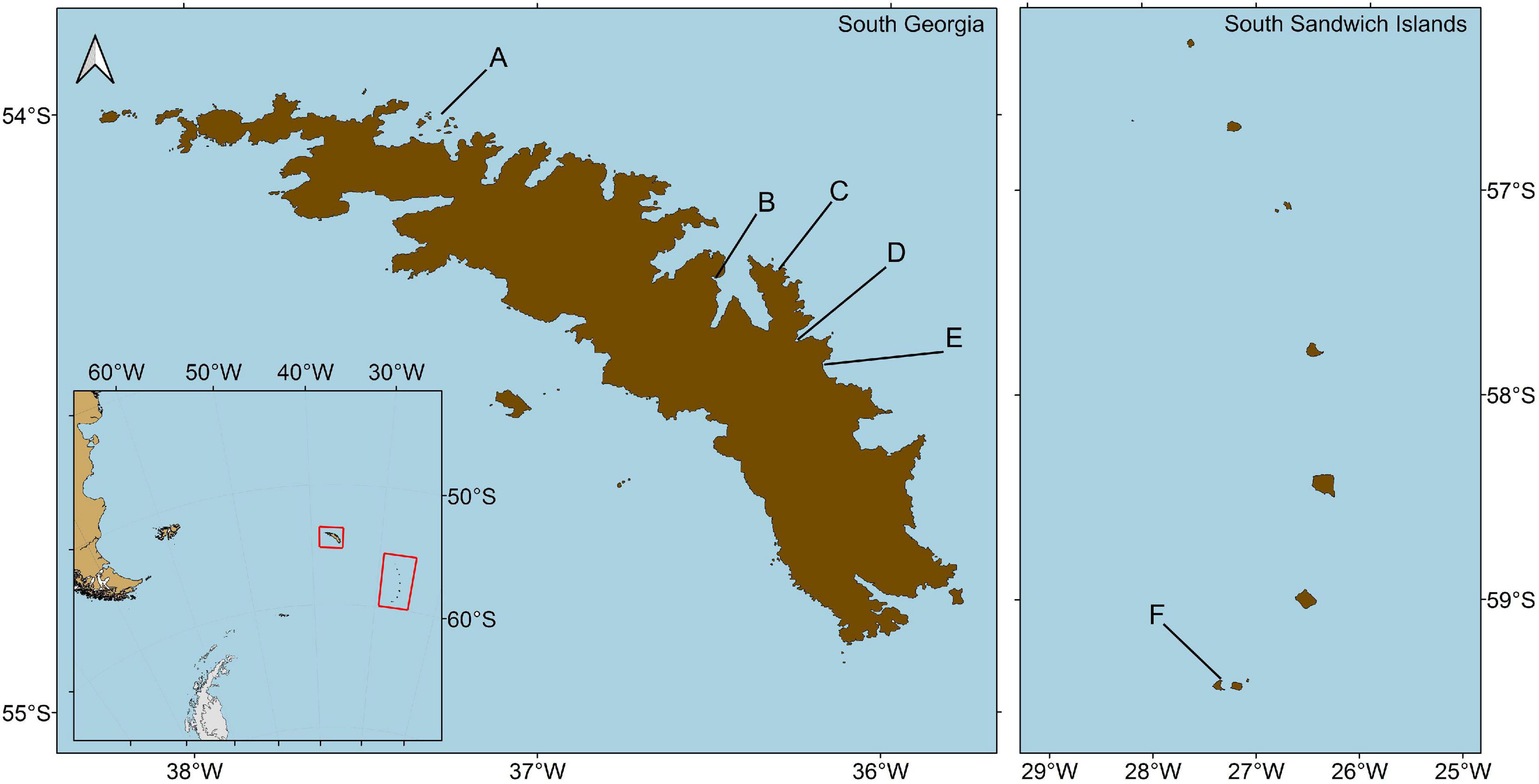
Figure 1. Location of South Georgia and the South Sandwich Islands in the South Atlantic, (A) Bay of Isles, (B) King Edward Cove, (C) Rookery Bay, (D) Hound Bay, (E) St Andrews Bay, (F) Beach Point, Thule Island.
The islands cover a total area of approximately 4,000 km2 with South Georgia being the largest, covering 3,755 km2. While much of the terrain is mountainous and unsuitable for wildlife, the low-lying coastal areas and smaller vegetated islands typically have high densities of seals and seabirds, particularly during the nesting and pupping season in the austral summer months (Croxall, 1979; Boyd, 1993; Boyd et al., 1996; Poncet et al., 2017). Vast colonies of up to tens of thousands of animals can often cover extensive areas. While some of these colonies are accessible to researchers via land routes from field huts and research stations, many of the largest colonies are on peninsulas that are isolated by glaciers, cliffs, and mountains, or they are concentrated on smaller offshore islands, and are only accessible by boat or potentially monitored through aerial surveys. This is particularly true of the South Sandwich Islands which are remote and difficult to land on due to rough sea conditions and steep, rocky shorelines.
The extent, inaccessibility and remoteness of these islands, along with the distribution and high abundance of wildlife, make accurate population monitoring a challenge when following traditional ground-based survey methods. Additionally, these islands are highly sensitive to accidental introductions of invasive plants, mammals and insects, with invasions having the potential to cause widespread destruction to the environment and enormous impacts on indigenous species including localised extinctions (Frenot et al., 2005; Martin and Richardson, 2019).
In order to improve the monitoring of wildlife on these remote islands, and in an attempt to mitigate our impact on the environment when conducting research, it is important to investigate new techniques, with a focus on emerging technologies, to update and develop new methods so as to conduct accurate, safe and efficient population surveys. One such technology, which has become a prominent scientific tool in recent years, is the development and advancement of UAVs (unoccupied aerial vehicles), also known as RPAs (remotely piloted aircraft) and more colloquially, drones. It has only been in the past few years that commercially available quadcopters and fixed wing UAVs have become affordable and reliable for professional use, allowing researchers to conduct highly detailed aerial surveys on a routine basis. Prior studies have shown that UAVs make it possible to conduct large scale population surveys with a far higher accuracy than ground counts (Ratcliffe et al., 2015; Hodgson et al., 2018; Dunn et al., 2021), in areas that may otherwise be difficult, risky or environmentally damaging to access (Goebel et al., 2015; Borowicz et al., 2018).
Long-term monitoring programmes have been established in the Southern Ocean for a number of decades, including the Commission for the Conservation of Antarctic Marine Living Resources (CCAMLR) Ecosystem Monitoring Programme (CEMP; Agnew, 1997), and the Southern Ocean Observing System (SOOS; Meredith et al., 2013). Such programmes set out to document change and to attribute causes of change. The use of UAVs now have the potential to enhance the objectives of such programmes, extending monitoring of ecosystem components where there is a critical need to observe and understand in order to better evaluate environmental change, so as to increase resilience to such change, and to ensure sustainable resource exploitation (Meredith et al., 2013). CEMP is focussed upon marine predators that are dependent upon Antarctic krill as a food resource (CCAMLR, 2014). SOOS has a broader focus, which also includes marine predators that depend upon many different prey resources. The Agreement on the Conservation of Albatrosses and Petrels (ACAP)1 is also supported through monitoring by members, and focuses solely upon procellariform seabirds with their diverse feeding habits. For all these taxa, the use of UAVs will allow researchers to assess and monitor populations at spatial and temporal scales previously limited by traditional monitoring techniques, enhancing established long-term monitoring and benefitting all such international programmes (Weimerskirch et al., 2018; Hyun et al., 2020; Dunn et al., 2021).
As well as supporting broad-scale regional programmes such as CEMP, ACAP and SOOS, UAVs also have the potential to enhance management at local scales. For example, monitoring of marine predators occurs at South Georgia at a number of sites. CEMP indicator species are monitored at Bird Island and at Maiviken; ACAP species are monitored at Bird Island and at Bay of Isles; and elephant seals are monitored in King Edward Cove. In addition to which, Oceanites2 conducts counts of penguin colonies (Foley et al., 2018) and the Penguin Watch programme3 conducts counts and camera monitoring (Youngflesh et al., 2021). All of these activities could be enhanced by UAV surveys.
(Table 1) given the abundance, diversity and widespread distribution of marine predators at South Georgia (Trathan et al., 1996) we have now initiated UAV aerial monitoring at key locations to supplement the existing monitoring, which was limited to colonies proximal to scientific stations. Here, we highlight three case studies to demonstrate the efficacy of UAV surveys, which we now consider to be essential, given the recent eradication of introduced mammalian species (Bazilchuk, 2013; Martin and Richardson, 2019), ongoing glacial retreat (Cook et al., 2010), and changing foraging opportunities at sea given the recovery of cetaceans (Zerbini et al., 2019; Calderan et al., 2020). Changes in the local ecosystem are now certain, but ascribing cause remains difficult. Moreover, it will remain difficult whilst monitoring data are sparse.
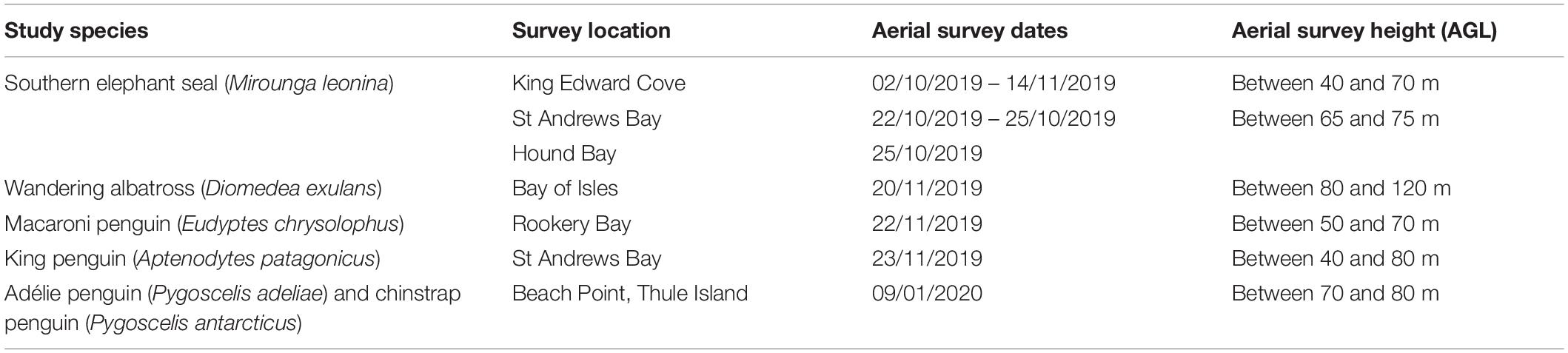
Table 1. Summary of surveys conducted during the study.
Materials and Methods
The studies took place at five locations on South Georgia (Figures 1A–E) and one location at the South Sandwich Islands (Figure 1F) between October 2019 and January 2020 (Table 1). At South Georgia southern elephant seal populations were surveyed along the coastline within King Edward Cove on the Thatcher Peninsula, and at Hound Bay and St Andrews Bay on the Barff Peninsula. Nine islands within the Bay of Isles were also surveyed with a focus on the wandering albatross population. Additionally, a king penguin colony at St Andrews Bay and a macaroni penguin colony at Rookery Bay were surveyed. As part of an expedition to the South Sandwich Islands a survey of a mixed Adélie and chinstrap penguin colony at Beach Point on Thule Island was carried out from a yacht.
Platform Specifications
All surveys utilised a commercially available quadcopter, DJI Mavic 2 Pro (DJI Inc., Shenzhen, China), equipped with the original 20MP RGB Hasselblad L1D-20c camera. The UAV was remotely piloted using the DJI GO 4 app (DJI Inc., Shenzhen, China; version 4.3) run on an iPhone 8 (Apple, Cupertino, CA, United States) or DJI smart controller (DJI Inc., Shenzhen, China). Being small and light the UAV was portable and did not require specialised launching or recovery equipment. The majority of flights involved terrestrial take-off and landing, apart from those to survey the Bay of Isles, Hound Bay and Beach Point on Thule Island, which were piloted from a vessel at sea within close proximity of the study site. Initial plans of using software to compile predetermined survey flight paths at South Georgia were dismissed, primarily due to limited internet access which would have been required to download the maps necessary for offline use when in the field, but also due to the imprecise location of targets within maps. Breeding colonies may expand, contract or shift location making it impractical to rely on predefined survey paths. The UAV was therefore controlled manually with the pilot configuring the camera settings to achieve consistent sets of imagery and estimating the level of overlap between images with attempts made to achieve at least 70% forward and lateral overlap. The majority of the surveys were flown at a horizontal speed of 5 m/s with the UAV set to capture a photograph every 2 s. An observer was present during flights to assist the pilot by keeping visual contact with the UAV and making observations of potential disturbance to wildlife. Briefings were given to observers by the pilot to ensure they were aware of emergency procedures, should an issue arise. The UAV pilots underwent training prior to the study and gained a Remote Pilot Qualification – Small (RPQ-S) and a Civil Aviation Authority Permission for Commercial Operation (CAA PfCO). Additional information on the setup of the UAV and flight procedures are available as Supplementary Material.
Flights were only conducted under suitable flying conditions and were made in accordance with the Air Navigation (Overseas Territories) Ordinance, following regulations set out by the Government of South Georgia and the South Sandwich Islands (GSGSSI) under Regulated Activity Permits RAP 2019/020, RAP 2019/024 and RAP 2019/050.
Case Study – Southern Elephant Seals
Southern elephant seals have been studied at South Georgia since the 1950s (Laws, 1956), however, only two complete whole island surveys of the population have been conducted, one in 1985 and another in 1995 (Rothery and McCann, 1987; Boyd et al., 1996). The majority of South Georgia’s elephant seal population haul out to give birth on the eastern side of the island with the greatest concentration, almost 50%, found along the eastern end of the north coast (Boyd et al., 1996). A number of significant haul out sites along this coastline are accessible to researchers but they have not been the focus of regular surveys due to their extent and the challenges of accurately and efficiently monitoring such large numbers of animals. It was along this coastline that we focussed our study.
Aerial surveys were conducted to monitor the population of southern elephant seals at three locations between the 2nd October and the 14th November 2019 during the annual pupping season. The surveys were conducted similarly at the three sites with the UAV being flown at a constant altitude of between 40 and 65 m above ground level (AGL) to produce orthoimages with a resolution of between 1.2 and 2 cm/pixel. The minimum altitude of 40 m AGL was identified as a height at which there would be little to no disturbance to wildlife based on similar studies using equivalent UAVs (McIntosh et al., 2018; Raoult et al., 2020). With the seals concentrated along the shoreline it was possible to fly along a single flight path, rather than having to carry out flight transects to cover larger study areas, this reduced the chances of animals moving between overlapping flight paths. Flights times were restricted by battery performance and none exceeded 20 minutes; all surveys were completed on a single battery charge.
Two of the three colonies, St Andrews Bay and Hound Bay (Figures 2B,C), were surveyed close to the estimated peak in pupping for the season. This date typically falls within the last week of October and is the time at which the majority of cows are on shore to give birth and suckle their pups (Laws, 1956; Rothery and McCann, 1987). St Andrews Bay was surveyed daily between the 22nd and 25th October, Hound Bay was surveyed once on the 25th October. These two sites are important breeding areas for the species, with St Andrews Bay being recognised as the largest gathering of southern elephant seals in the world and Hound Bay containing the third largest population on South Georgia (Boyd et al., 1996). These colonies, on the Barff Peninsula, were only accessible to researchers by boat under suitable environmental conditions, limiting the time and frequency of surveys over the course of the season. The field hut at St Andrews Bay was equipped with a generator which allowed for the frequent recharging of the UAV batteries in order to conduct daily surveys.
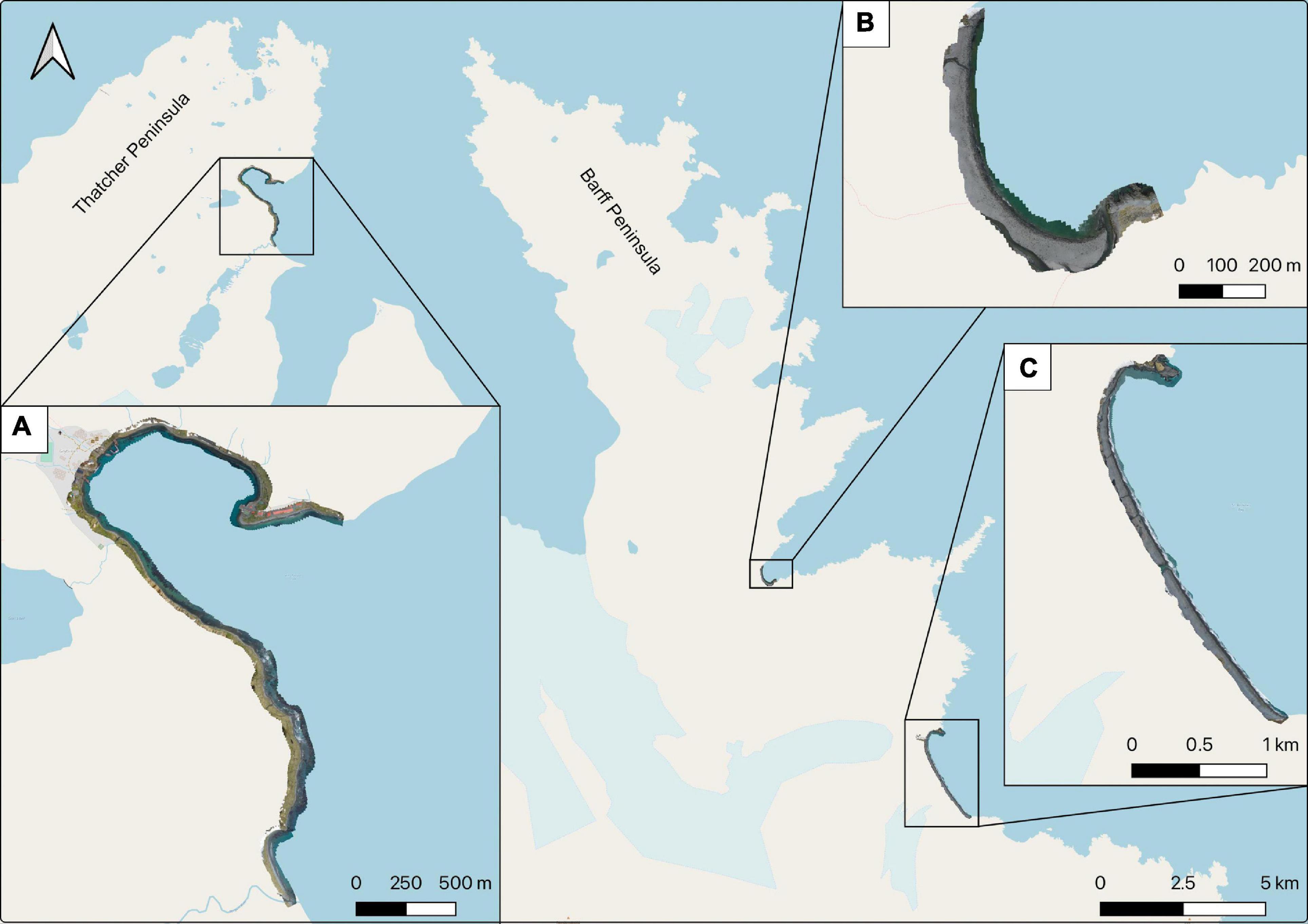
Figure 2. Orthomosaic images overlaid on a base map showing the location of southern elephant seal aerial surveys at South Georgia, (A) King Edward Cove on the Thatcher Peninsula, (B) Hound Bay on the Barff Peninsula, (C) St Andrews Bay on the Barff Peninsula.
The third study site, within King Edward Cove on the Thatcher Peninsula (Figure 2A), was within walking distance of the King Edward Point Research Station. It was therefore monitored frequently throughout the season with opportunistic flights made between the start of October and the middle of November. The population of southern elephant seals within King Edward Cove falls under the long-term monitoring research conducted by the British Antarctic Survey and as such the aerial surveys were made in conjunction with established ground-based monitoring protocols. The population of elephant seals along the coastline, between Hope Point and Penguin River, was monitored weekly by an observer who conducted two consecutive ground counts, from which an average was taken. Animals were categorised as cows, bulls, suckling pups, and weaned pups. Aerial surveys were conducted to coincide with the weekly ground counts and involved flying along a single flight path at a height of between 40 and 60 m AGL.
Counts of southern elephant seals from the aerial imagery were all made by a single observer using opensource software, DotDotGoose (Ersts, 2019). The seals were differentiated into the four distinct categories used during the ground counts; cows, bulls, suckling pups and weaned pups, based on their size, pelage colouring, location on the beach, and proximity to other individuals (Figure 3). The observer had previously worked with the species in the field over numerous pupping seasons and, due to experience, did not need training on identification of the classes assigned to the study. Verification was conducted by a second observer who assessed the original count, identifying any additional or incorrectly identified animals.
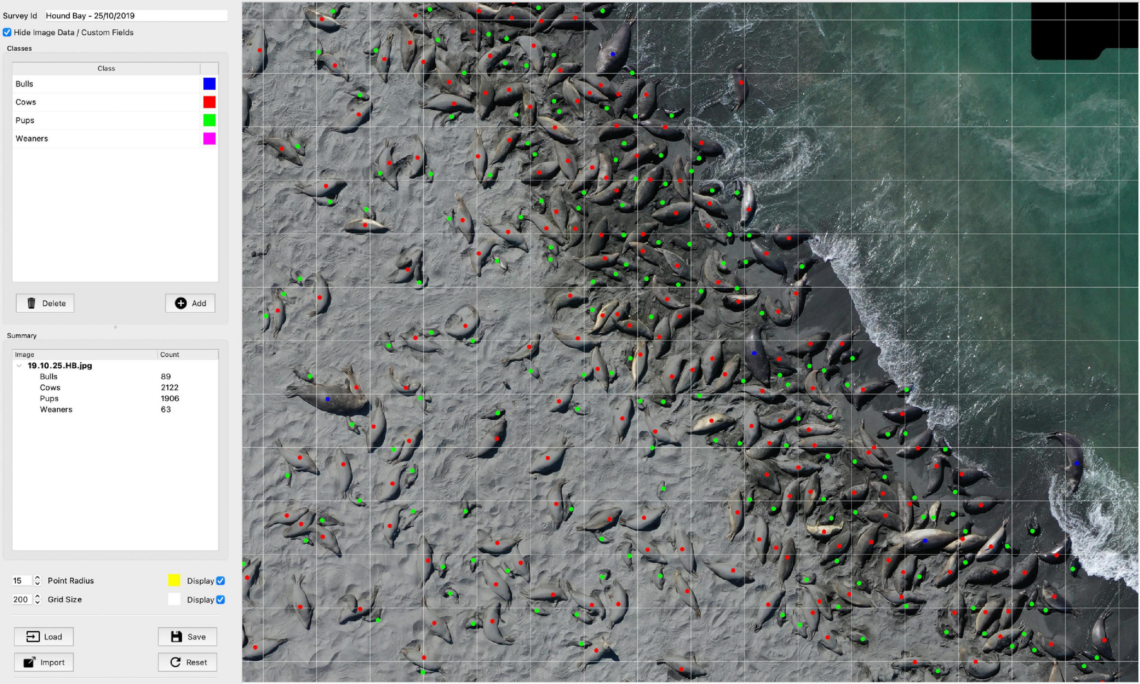
Figure 3. Section of southern elephant seal survey area at Hound Bay from the 25th of October 2019 illustrating the use of DotDotGoose counting software, extreme sexual dimorphism in the species allowed the observer to easily distinguish between cows and bulls.
Case Study – Wandering Albatross – Bay of Isles
The majority of wandering albatross nesting sites are concentrated along the north west of the South Georgia archipelago with 16% of the population historically found on nine small islands within the Bay of Isles (54.0270° S, 37.2567° W – Figure 4) (Poncet et al., 2017). The two largest islands, Albatross and Prion, contain the majority of the population of wandering albatross within the Bay of Isles and are monitored annually with ground surveys conducted to record nesting activity in January each year. Follow-up monitoring is conducted on Prion Island to study the breeding success of the population but the same is not done on Albatross Island due to the ecological sensitivity of the island and the logistical challenges involved. The seven smaller islands are infrequently surveyed due to their inaccessibility and their lesser importance as nesting sites, however, they still make up approximately 20% of the population within the Bay of Isles. The most recent surveys conducted in 2003/2004 and 2014/2015 show a decrease in the population across all of the islands (Poncet et al., 2006, 2017), but the decline in the Bay of Isles is smaller than elsewhere at South Georgia (Rackete et al., 2021).
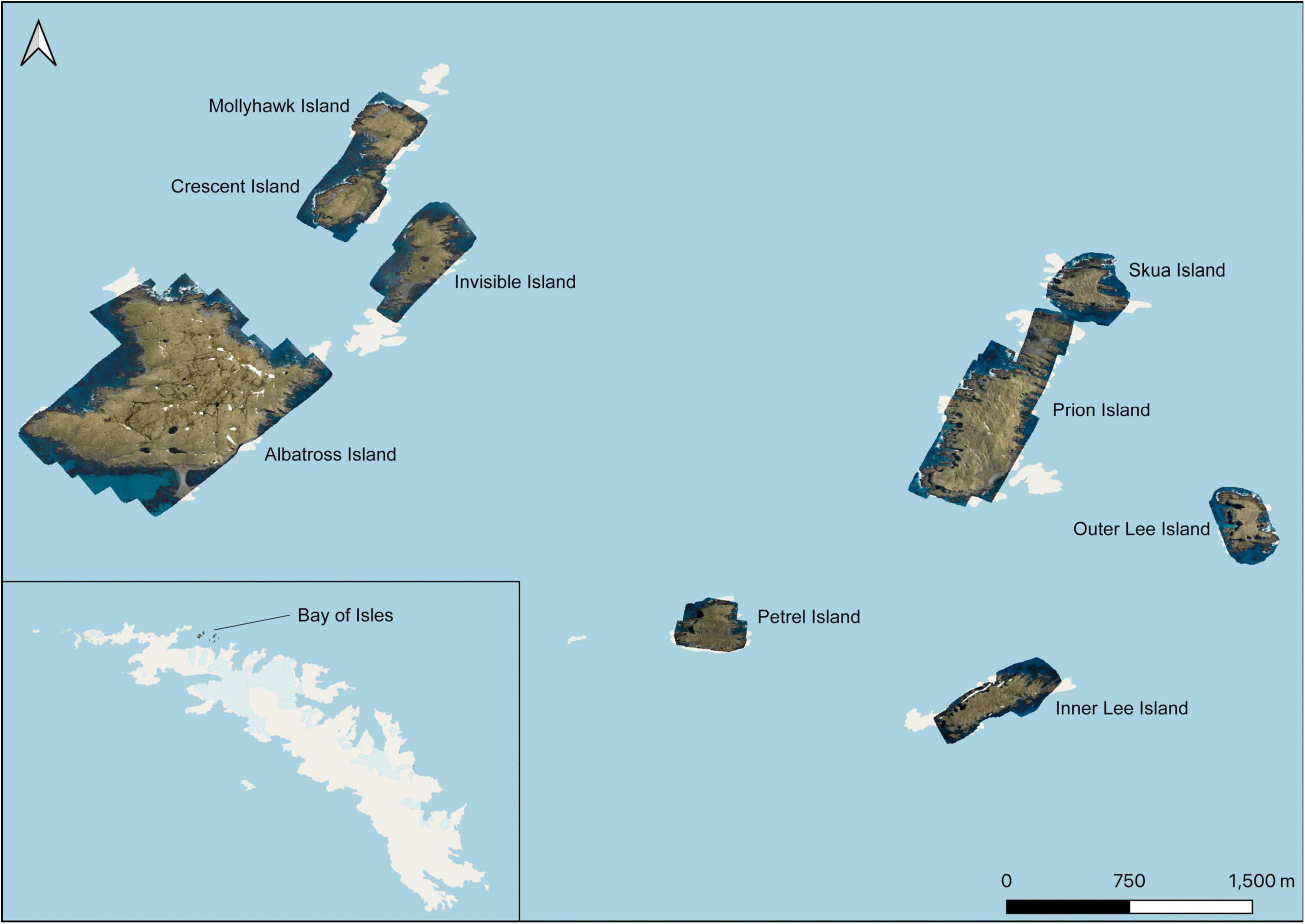
Figure 4. Orthomosaic images overlaid on a base map showing the location and extent of the aerial surveys conducted on the 20th of November 2019 from varying altitudes of between 80 and 120 m AGL within the Bay of Isles at South Georgia.
Aerial surveys of all nine historical nesting islands within the Bay of Isles were conducted on the 20th November 2019. Flights were made from the deck of the MV Pharos SG which was positioned within close proximity to the islands. A constant altitude of 120 m AGL was selected in order to efficiently cover the extent of the islands as well as to allow for the variability in topography, particularly when surveying Albatross Island which has an elevation of 80 m above sea level. A maximum altitude of 120 m AGL was in line with Air Navigation Ordinance regulations but was also at the limit of the utility of the spatial resolution provided by the UAV camera for identifying and counting the study species. As the surveys were conducted over large areas it was necessary to fly transects in order to cover the entirety of each island, this was done manually, with an estimated 70% overlap between flight paths.
In most cases surveys were completed on a single battery charge, however, during surveys of larger areas, such as Albatross and Prion islands, it was necessary to retrieve the UAV part way through the survey, change the battery and return to complete the remainder of the survey.
Orthoimages of islands within the Bay of Isles were mapped using QGIS (QGIS., 2020). Wandering albatross chicks and adults were identified and recorded on each of the nine surveyed islands. Existing coordinates of the nests on Albatross and Prion islands, collected from ground-based surveys in January 2019, were overlayed and acted as reference points for identifying chicks as well as for estimating fledgeling survival. The survival rate of the chicks on Prion Island was recorded during a ground-based survey of the population on the 12th October 2019, a month prior to the aerial survey.
Case Study – Penguins on South Georgia and South Sandwich Islands
St Andrews Bay has the largest population of king penguins on South Georgia with an estimated 250,000 breeding pairs (Foley et al., 2020), with the terrain allowing the colony to sprawl over approximately 1 km2. While ground and satellite counts have been made of the population at St Andrews Bay, these methods have their limitations, with ground counts lacking accuracy and verifiability, and satellite counts lacking resolution. Macaroni penguins nest along the north-east facing coastline of South Georgia with colonies found either on rocky slopes, such as at Bird Island and the Willis Islands, or within tussock grass habitat, such as at Rookery Bay where our survey took place. Mixed colonies of Adélie and chinstrap penguins nest on Thule Island in the South Sandwich Islands. While distinguishable from the ground, the two species can be misidentified if aerial imagery lacks a high enough resolution.
Aerial surveys of king, macaroni, Adélie and chinstrap penguins were made on expeditions with SY Pelagic Australis (Pelagic Expeditions) and MV Ocean Endeavour (Quark Expeditions). In the case of Rookery Bay and St Andrews Bay, located on the Barff Peninsula at South Georgia, flights were made from land in good conditions with surveys being conducted at an altitude of between 50 and 100 m AGL. Beach Point on Thule Island was surveyed at an altitude of between 50 and 60 m AGL but was piloted from the yacht with considerable movement at take-off and landing.
Images were recovered from the UAV after each flight and saved on external storage media, in duplicate, for further processing. The images were initially organised and processed using Adobe Photoshop Lightroom Classic (Adobe Systems Inc., San Jose, CA, United States) with keywords assigned to each unique survey, including additional metadata about the flights. Exposure corrections were made as necessary and altered image files were exported as georeferenced JPEGs for further processing. Agisoft Metashape (Agisoft 2020, Version 1.6.2)4 was used to align and stitch the images from each unique survey to form orthomosaic images. These were exported as georeferenced TIFF files for use in mapping software, and as lower resolution JPEG files for counts. The resolution of the orthoimages ranged from 1.2 cm/pixel in surveys conducted at 40 m AGL to 3.2 cm per pixel for those at 120 m AGL. Ground control points were not used during the surveys.
Results
Southern Elephant Seals
Between the 2nd October 2019 and the 14th November 2019, a total of 50 aerial surveys were conducted to monitor southern elephant seal populations at King Edward Cove, St Andrews Bay and Hound Bay. It was possible to obtain complete, verifiable, counts of bulls, cows, suckling pups and weaned pups from the aerial imagery captured at all sites. Images captured from heights of between 40 and 75 m AGL provided adequate spatial resolution to clearly identify individual animals with only a single case of disturbance recorded to wildlife within the study areas. The case of disturbance involved a group of approximately 10 kelp gulls (Larus dominicanus) briefly mobbing the UAV, the birds did not come into contact with the UAV and no injuries were recorded. Disturbance following this incident was mitigated by increasing the altitude at which the UAV was flown, and the birds showed no further interest.
St Andrews Bay (Figure 5) and Hound Bay were surveyed close to the expected peak of the pupping season, typically within the last week of October. At this time the majority of cows were hauled out on the beaches to give birth and suckle their pups. Four consecutive daily counts at St Andrews Bay showed a gradual decrease in the number of cows hauling out each day with a difference of only 30 additional females (0.49% of the total number hauled out) between the 24th and 25th October 2019. This figure suggests that the peak of the pupping season was on, or very close to, the 25th October, with a total of 6,074 cows recorded across the beach. On this day a total of 396 bulls, 5341 suckling pups and 155 weaned pups were recorded at St Andrews Bay.
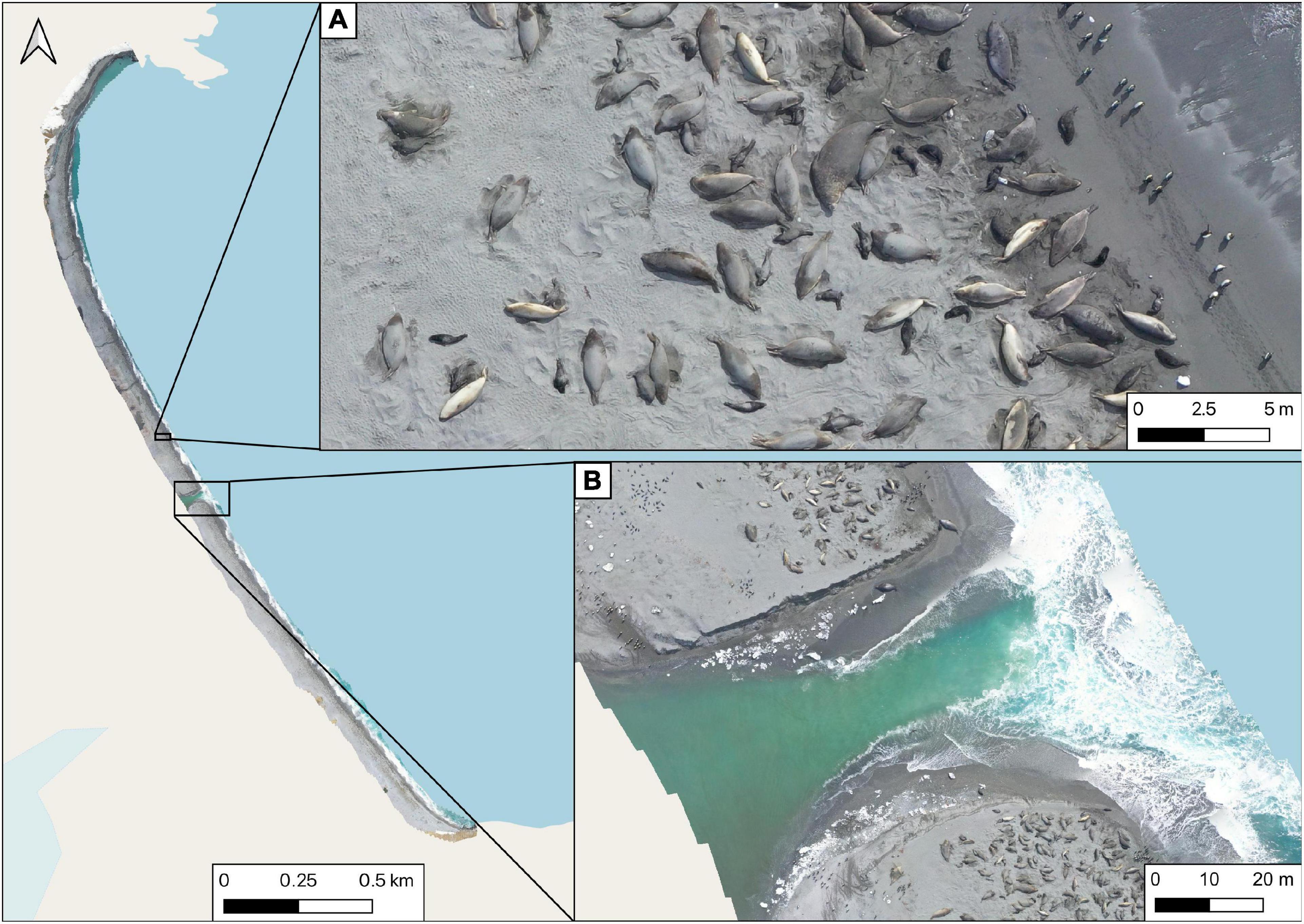
Figure 5. Orthomosaic showing the extent of the aerial survey at St Andrews Bay on the 23rd October 2019 from 60 m AGL, (A) higher resolution showing southern elephant seals on the beach, (B) outflow from a glacial lake acting as a natural barrier which would have precluded researchers from conducting ground counts.
A single aerial survey was conducted at Hound Bay on the 25th October with 2,122 cows, 89 bulls, 1,906 suckling pups, and 63 weaned pups recorded. Time and battery constraints limited the extent of the survey within Hound Bay and so focus was placed specifically on the greatest density of seals hauled out along the main stretch of sandy beach with distinct terminal points.
King Edward Cove was surveyed frequently with opportunistic flights made almost daily at King Edward Point, and weekly along the entire coastline, under suitable conditions (Figure 6). Based on the daily counts around King Edward Point, the peak pupping date for this colony was the 28th October. Comparative ground counts along beaches within King Edward Cove (Figure 7) showed variation between methods with aerial counts consistently recording higher numbers of animals, particularly of cows and pups on beaches with higher densities of animals.
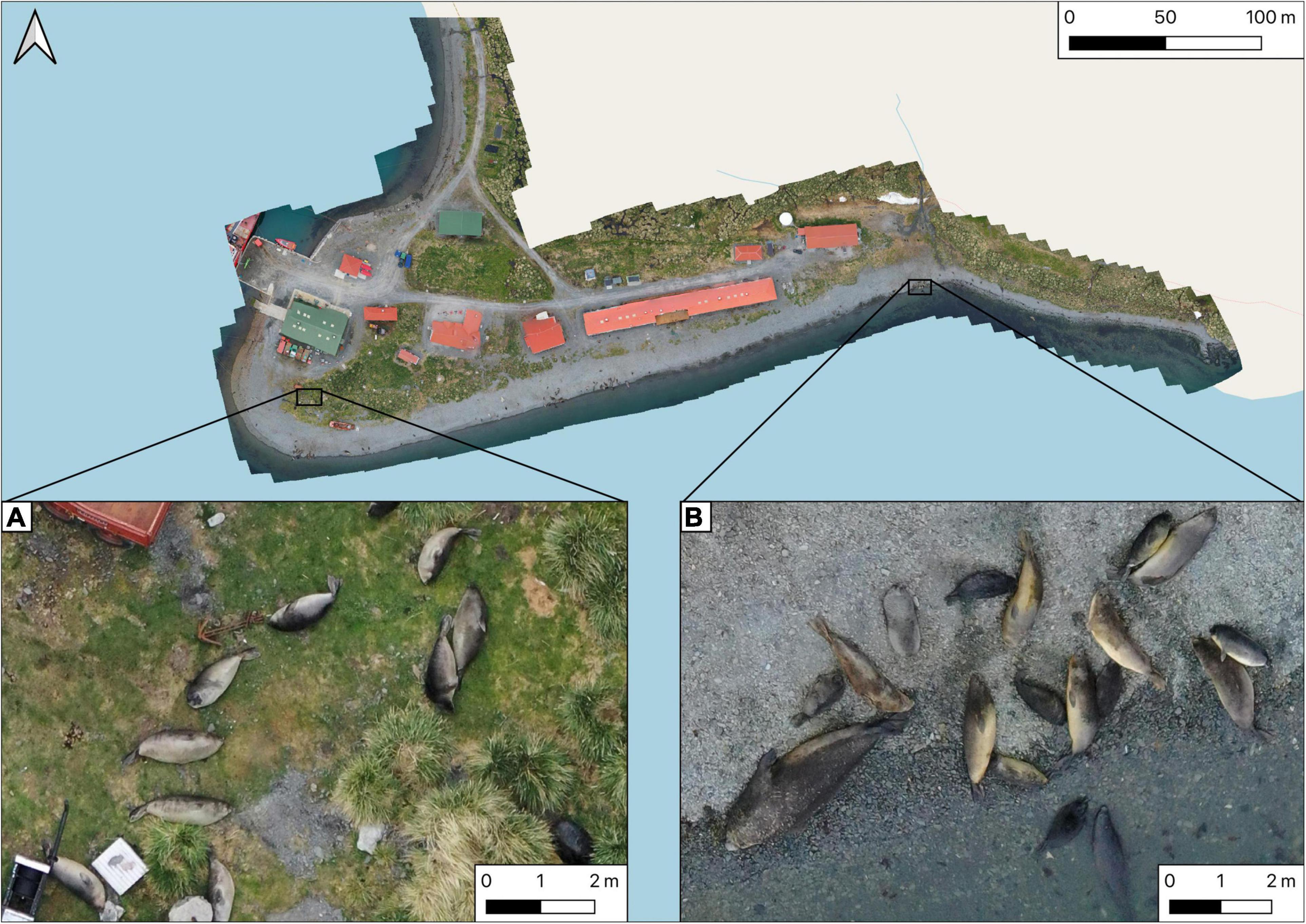
Figure 6. Orthomosaic showing a section of the survey of southern elephant seals in the area around King Edward Point on the 15th of November 2019 from 40 m AGL, (A) weaned pups gathered away from the beach, (B) cows, pups and a bull on the shoreline.
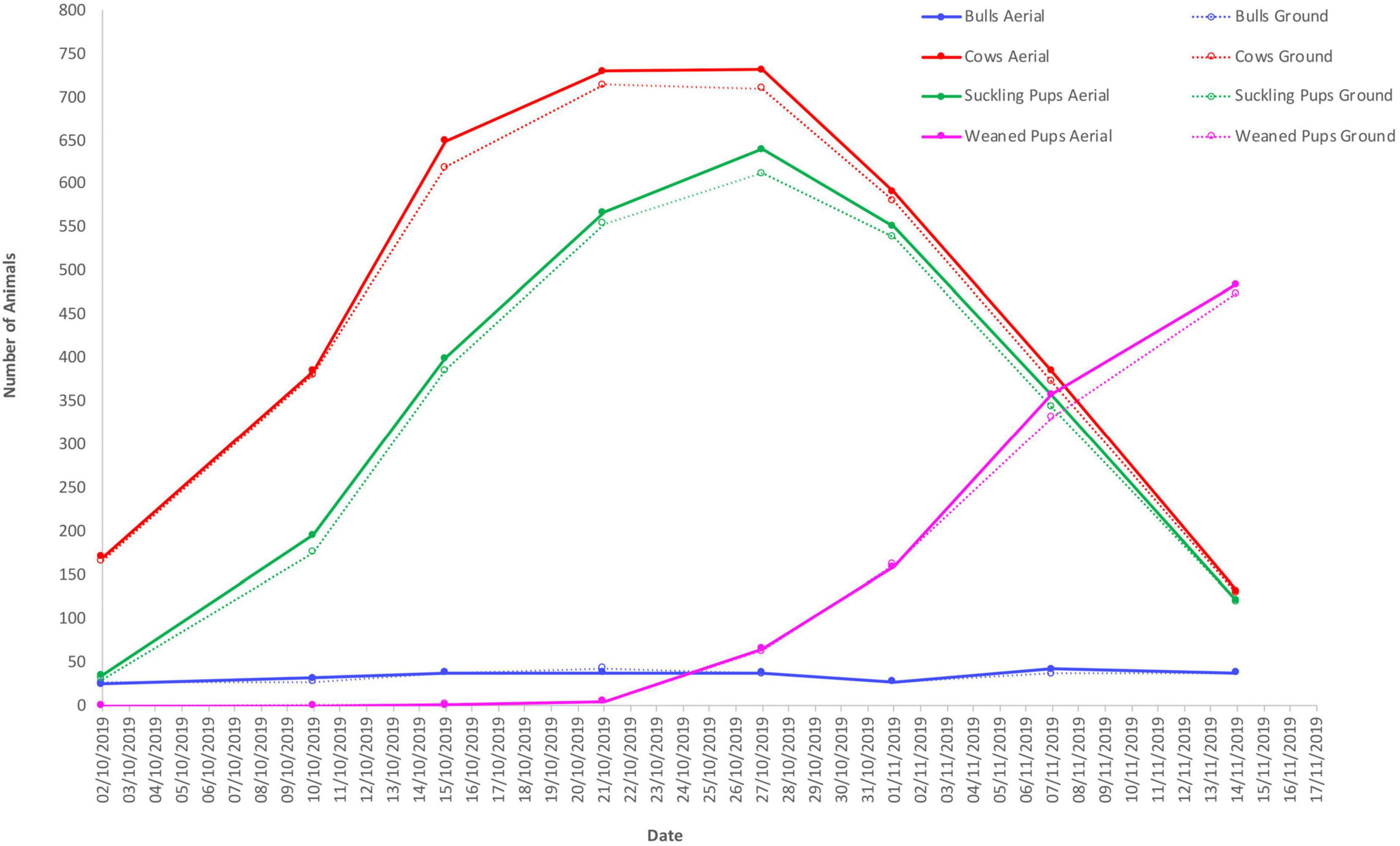
Figure 7. Comparative ground and aerial counts of southern elephant seals within King Edward Cove between the 2nd of October and the 14th of November 2019.
Wandering Albatross
An area of approximately 3 km2 covering nine islands within the Bay of Isles was surveyed over 4 h on the 20th November 2019. The orthomosaic images produced from these surveys were of a high enough spatial resolution to allow for the identification and quantification of wandering albatross adults and chicks across the islands (Figure 8). In total 143 wandering albatross chicks and 48 adults were identified (Table 2). Surveys conducted at 120 m AGL were at the upper limit of spatial resolution that was useful for accurately surveying wandering albatross and showed high pixilation when zoomed in Figure 8A.
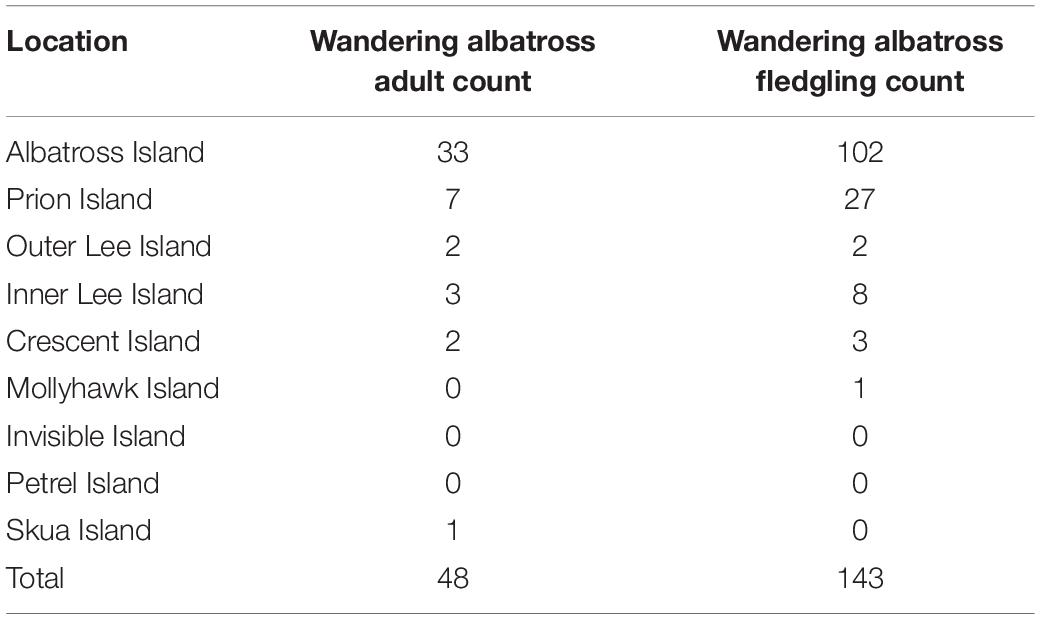
Table 2. Number of wandering albatross adults and fledglings recorded from aerial imagery captured on the 20th November 2019 at the Bay of Isles.
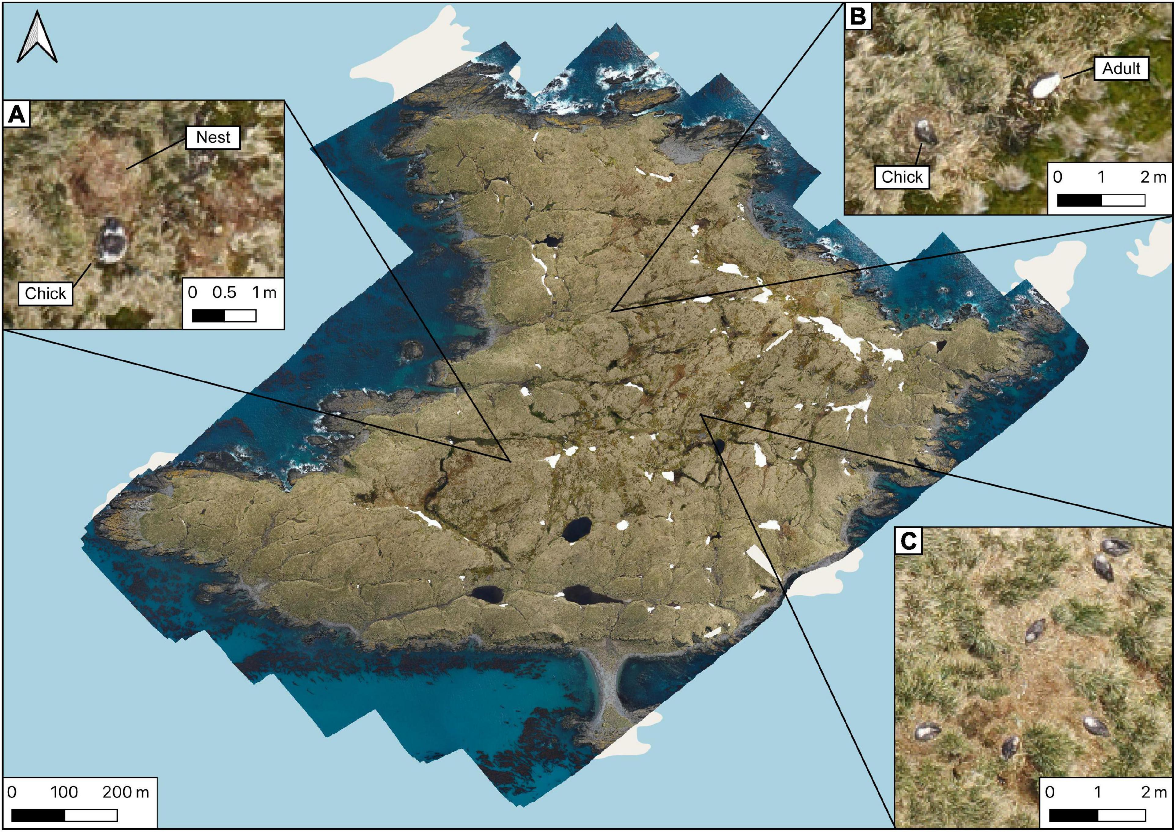
Figure 8. Orthomosaic of Albatross Island produced from images taken at 120 m AGL on the 20th November 2019, (A) wandering albatross fledgling close to its nest, pixilation is noticeable with lower spatial resolution, (B) wandering albatross fledgling on nest with adult in attendance, (C) group of giant petrels.
The fledgling survival rates calculated for Albatross and Prion Island were 74.5% and 64.3%, respectively.
Penguins at South Georgia and the South Sandwich Islands
In all cases, aerial surveys of the penguin colonies provided sufficiently clear imagery to identify individual birds, but with varying levels of success in population monitoring of each species.
Population monitoring of king penguins at St Andrews Bay was successful, with the UAV able to survey the extensive colony (Figure 9). Adults and chicks were clearly distinguishable in the imagery which, once fully analysed, will allow for a full census of the population at this site.
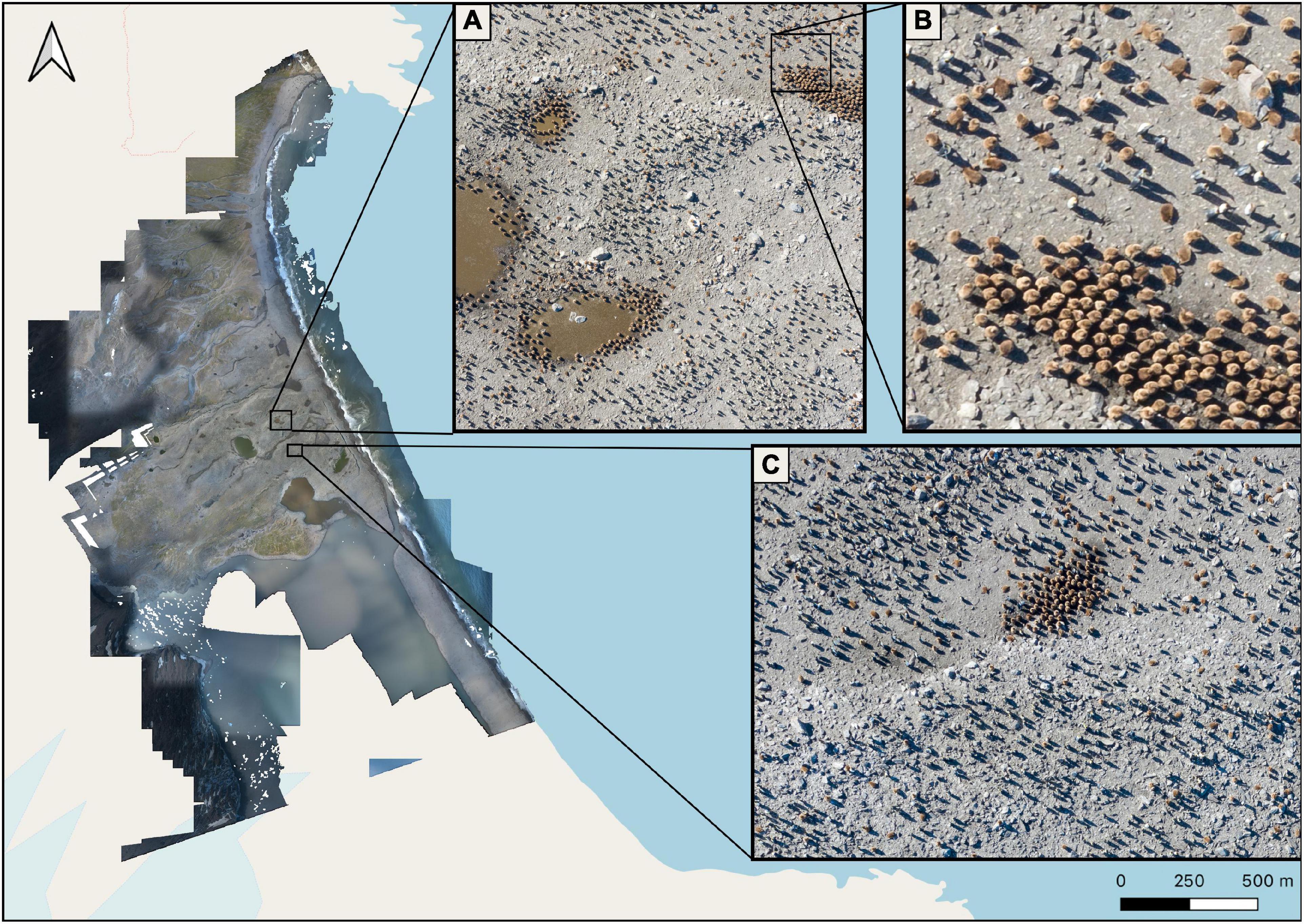
Figure 9. Aerial survey of king penguins at St Andrews Bay on the 23rd November 2019 at an altitude of between 40 and 80 m AGL, (A) Section of the colony showing king penguin adults and chicks, (B) higher resolution image of king penguin chicks, (C) king penguin chicks in a crèche surrounded by adults.
While individual penguins and nests are clearly visible at the Rookery Bay macaroni penguin colony, their use of tussock grass habitat did not allow an accurate count of the whole colony (Figure 10). It is unclear whether correction factors based on ground counts could be applied, but the use of UAV flights is clearly not as advantageous for this species as for pygoscelis penguins and king penguins that nest in open ground. At other sites, macaroni penguins nest in more open habitats, on rock or scree, so counts of this species at some sites will be feasible.
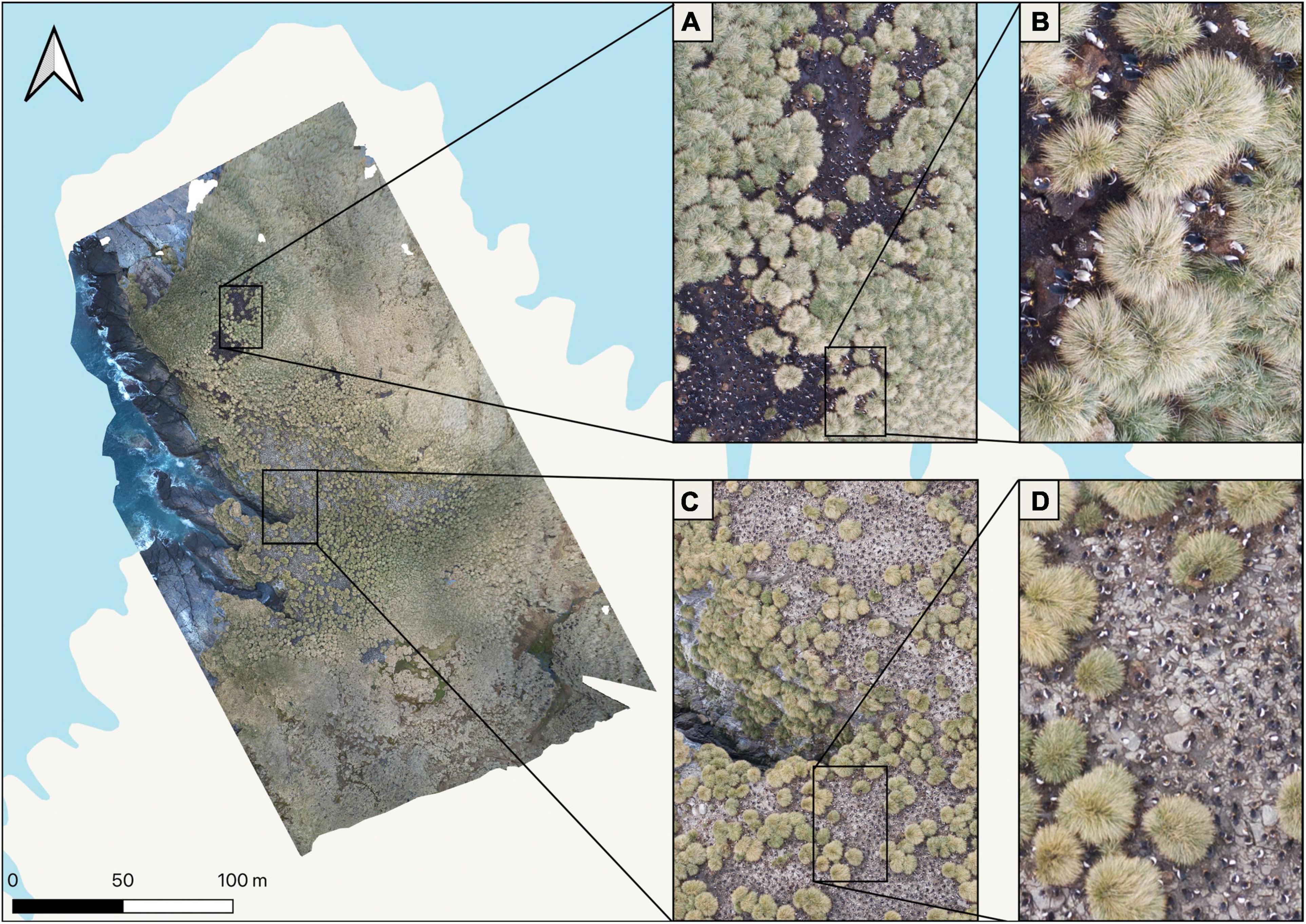
Figure 10. Orthomosaic of the macaroni penguin colony at Rookery Bay on the 22nd November 2019 from an altitude of between 50 and 70 m AGL, (A–D) higher resolution imagery showing the limitations of the UAV when surveying populations obscured by vegetation.
By launching the UAV from the yacht, it was possible to assess the remote and inaccessible mixed colonies of pygoscelis penguins on the South Sandwich Islands without the need to go ashore. In the mixed colony at Beach Point, species differentiation relied on substantial local knowledge from previous visits as well as nest colouration to differentiate between species (Figure 11). Flights closer to 40 m AGL appear necessary to distinguish species based on single observations, although this is closer to the level at which disturbance may become an issue.
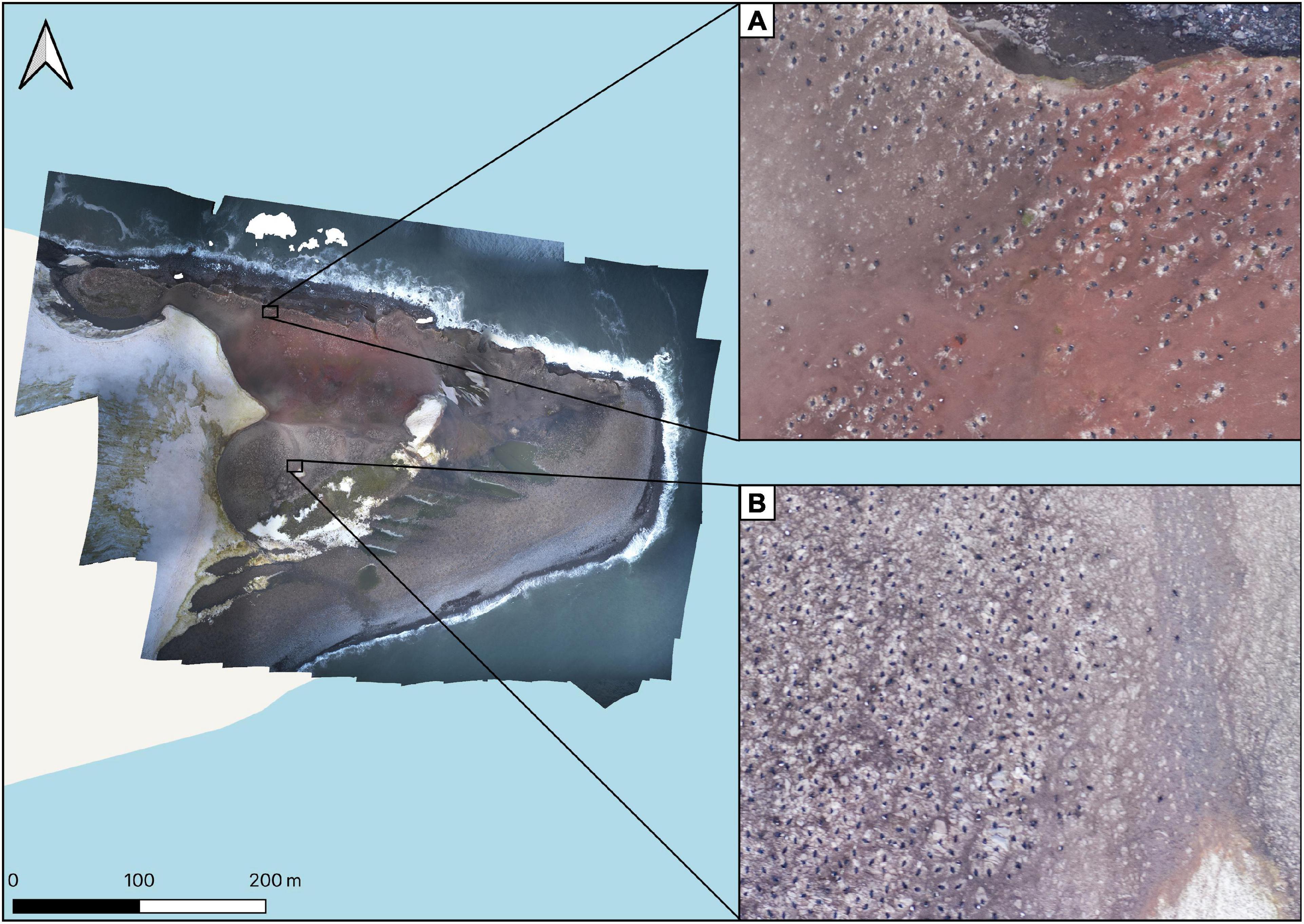
Figure 11. Orthomosaic of Beach Point, Thule Island on the 9th January 2020 from altitude of between 50 and 60 m AGL, (A) nesting chinstrap penguins, (B) nesting Adélie penguins.
Discussion
With increasing concerns about the impacts of climate change and the expansion of the fishery for Antarctic krill (Trathan et al., in press), there is an urgent need to increase our monitoring of sentinel populations, such as the land-breeding seals and seabirds on South Georgia and the South Sandwich Islands. To date, monitoring has been largely restricted to colonies proximal to research stations (Bird Island and King Edward Point; Table 3), but those colonies may not be representative and impacts of fishing may be spatially constrained (Trathan et al., in press). Here we have demonstrated the efficacy of UAV surveys for many species, which will enable us to extend the existing monitoring to new locations and potentially provide a consistent monitoring programme to support the management of SGSSI and the associated Marine Protected Area. Any monitoring needs to be carefully planned and requires a detailed understanding of breeding chronology to ensure timing is appropriate and comparable between seasons. An indication of potential species, sites and timing for UAV monitoring is given in Table 3. Such extended monitoring will provide a much more detailed assessment of the populations and an indication of the status of the ecosystem and contribute to management by international treaty organisations such as CCAMLR and ACAP.
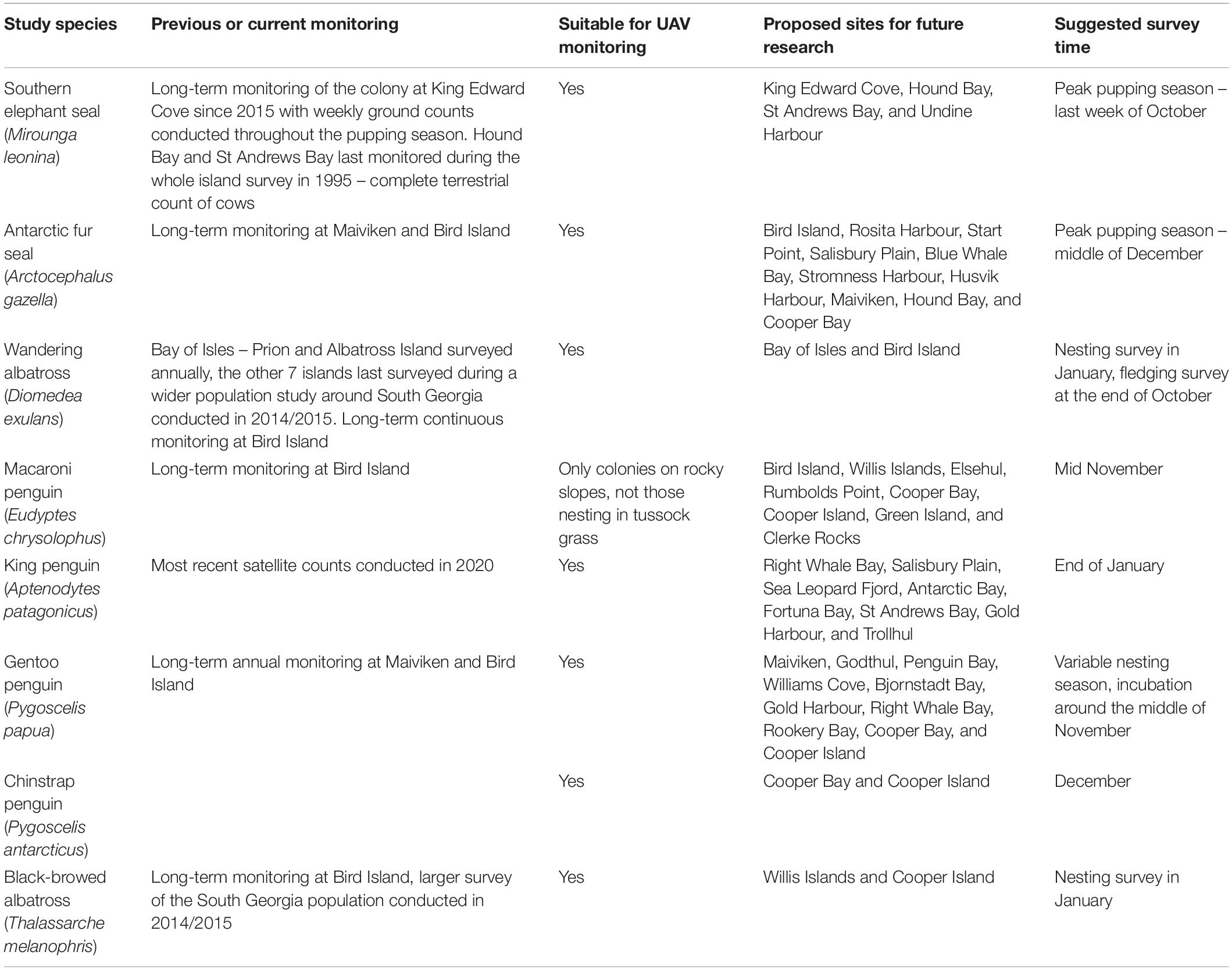
Table 3. Summary of previous or current monitoring programmes and proposed location and timing for long-term UAV monitoring of seal and seabird species at South Georgia.
Over the course of the austral summer, we were able to conduct aerial surveys over extensive areas of land, covering populations of wildlife at far higher densities than would otherwise have been possible during ground-based surveys within the same timeframe in the field. All of this was done safely, with minimal disturbance to wildlife, and gave access to areas that would otherwise have been challenging or impossible to survey using traditional methods. In addition to the case studies outlined here, the UAV was also utilised to survey colonies of Antarctic fur seals (bulls, cows, and pups) at long-term monitoring sites at Maiviken and survey nesting adults and chicks in the gentoo penguin study colony. In both cases the UAV provided quick, safe counts with minimal disturbance to the animals.
Not only were the aerial surveys more efficient to carry out but the imagery provided more accurate counts than comparative ground-based surveys, with the additional benefit of being verifiable by secondary observers (Dunn et al., 2021). This was clear from the southern elephant seal monitoring within King Edward Cove, which recorded consistently higher numbers of animals, particularly cows and pups, in the aerial counts. This level of accuracy is comparable with that from other UAV studies and comes as no surprise as smaller animals are easily obscured within high density colonies during ground level counts which only provide an oblique view of the population (Hodgson et al., 2016; Sweeney et al., 2016; McIntosh et al., 2018). The vertical perspective provided by UAV is limited to surveying colonies of animals in areas that are clear of obstructions, such as vegetation or near-vertical or over-hanging terrain. Surveys of the macaroni penguin colony illustrate the limitations of the UAV with birds nesting in tussock grass often being obscured. This challenging terrain makes surveying macaroni penguins at such sites difficult not only for aerial surveys but for ground-based surveys too.
Safety, not only for the researchers but also the environment and wildlife, was an important factor when considering the use of UAVs. When working around territorial land breeding marine mammals, such as southern elephant seals and Antarctic fur seals there is a risk of injury to researchers (Kouliev and Cui, 2015). Additionally, the presence of researchers in close proximity to seabird and marine mammal colonies, which is often required when conducting ground based surveys, can lead to changes in behaviour and disturbance of wildlife during observations (Engelhard et al., 2002; Viblanc et al., 2012). A number of studies have looked at wildlife reactions to UAVs and based on observations have provided recommendations for limiting disturbance (Hodgson and Koh, 2016; Rümmler et al., 2018; Weimerskirch et al., 2018). The majority of these studies have shown that seabirds and marine mammals are minimally disturbed by the presence of a UAV when flown at heights above 60 m AGL (McIntosh et al., 2018; Weimerskirch et al., 2018; Wang et al., 2019; Dunn et al., 2021). And with continual improvements in propeller and body design UAVs are becoming even quieter and more discreet. Therefore, by launching a UAV from a safe location proximal to the study area, and by flying responsibly and in accordance with guidelines and regulations, a pilot and observer are able to carry out aerial surveys well out of harm’s way with reduced disturbance to wildlife.
Biosecurity is of major concern throughout the sub-Antarctic with invasive species causing widespread environmental damage, and being responsible for major declines and even localised extinctions of a number of species on remote islands (Frenot et al., 2005). Intensive biosecurity programmes exist at South Georgia and the South Sandwich Islands and successful eradication programmes have been conducted, at great expense, to eradicate or control the spread of invasive species, but the most effective way to protect the islands is by avoiding unnecessary landings (Government of South Georgia and the South Sandwich Islands., 2019; Martin and Richardson, 2019). There are also increasing concerns over the accidental introduction of disease to populations of seabirds and seals which is an additional reason for researchers to limit contact with wildlife if possible (Grimaldi et al., 2011, 2015). We show that it was possible to successfully survey remote islands, such as those within the Bay of Isles and the South Sandwich Islands, without needing to go ashore, thereby mitigating the risks of accidentally introducing disease or invasive species.
It has been almost 25 years since the last complete survey of southern elephant seals on South Georgia, despite recommendations that surveys be conducted at major breeding sites at least every 5 years (Boyd et al., 1996). Our study provides the first population census at St Andrews Bay and Hound Bay, identified as the first and third most populous breeding beaches on South Georgia, respectively, and it will hopefully lay the foundations for future, regular monitoring of these important breeding beaches (Boyd et al., 1996). Traditionally only cows were recorded during large ground based surveys, with pups potentially providing useful statistics on the population but being considered too challenging to census accurately (Boyd et al., 1996). Detailed aerial surveys now allow us to census the entire population, looking at not only cows and pups, but identifying bulls too, thanks to the extreme sexual dimorphism exhibited in the species. Weaned pups are also distinguishable, typically having a lighter pelage than suckling pups and, having moved away from the main harems, grouping together on the upper sections of the beaches. A more holistic view of the population will give us a greater understanding of the population dynamics and a better insight into the health of the species.
The aerial surveys within the Bay of Isles allowed for a full census of fledgeling and adult wandering albatross across the nine islands, giving the first breeding success data for Albatross Island since 2002, providing information on fledgeling dates for Prion Island, and giving the first records of fledglings on the seven smaller, less well studied islands, in recent years (Poncet et al., 2006, 2017). The aerial survey of Prion Island on the 20th November 2019 found five fewer wandering albatross chicks than were found during a ground-based census of the population conducted on the 12th October 2019. This was not expected as records from a long-term study colony at Bird Island, located 50 km west of the Bay of Isles, showed that only one chick out of fifty-nine had fledged by this date with the median fledging date being the 7th December 2019. Having survived to this age and appearing healthy during the ground survey a month earlier, and with no evidence of carcasses seen in the aerial imagery, it is unlikely that the chicks had died, so either they were overlooked, or they had fledged earlier than expected. Differences in the breeding biology of wandering albatross at Bird Island and in the Bay of Isles has been noted previously, so further detailed study of this site is warranted (Rackete et al., 2021). The surveys were conducted later in the season than originally planned, with the first attempt a month earlier being postponed due to high winds and poor visibility. By the time of the survey the majority of fledglings, having lost their white down, appeared as mottled black in the images, making them less conspicuous than they would have been a month earlier. While there is a size difference between wandering albatross fledglings and giant petrels, in some cases their colouration made it challenging to distinguish between the two species, especially in areas with a lower spatial resolution as a consequence of flying at constant height over variable terrain (Figures 8A,C). Adult birds, with their white plumage were highly conspicuous (Figure 8B), and future surveys, conducted at the start of the nesting season, will provide useful information on the population of the species within the Bay of Isles.
The limitations of spatial resolution in the aerial imagery were also illustrated in the survey from the South Sandwich Islands. While individual penguins could be seen from the imagery, identification of the two species nesting alongside one another was assisted with background knowledge of the location and distribution of the colonies from previous visits to accurately distinguish one species from the other. To improve the spatial resolution using a UAV with a similar sensor to that of the Mavic 2 Pro it would be necessary for the surveys to be conducted at a lower altitude, however, this may cause disturbance. Alternatively, a higher resolution camera could be used but a larger more costly UAV would be required to carry the extra payload. The benefit of higher resolution aerial imagery was illustrated at Signy Island where (Dunn et al., 2021) used a UAV equipped with a larger sensor and were able to distinguish between sympatrically breeding Adélie and chinstrap penguins (Dunn et al., 2021). While limitations for surveying mixed colonies, or single species colonies nesting in complex environments with obstructions of terrain or vegetation, aerial surveys of single species colonies nesting on open terrain, such as king penguins at St Andrews Bay, proved very successful.
Wind and precipitation are a major limiting factor when considering the use of UAVs for wildlife monitoring. The UAV used in this study, DJI Mavic 2 Pro, has a maximum recommended wind resistance limit of between 29 and 38 km h–1 and lacks any water resistance, so it can only be operated in relatively calm, dry conditions. As the technology and design of UAVs improve, environmental conditions will become less limiting but for now researchers will have to work within the bounds of current devices.
An alternative to UAV imagery is satellite imagery, which is becoming more widely used in population monitoring (McMahon et al., 2014; Wang et al., 2019; Strycker et al., 2020). However, satellite images can only be captured on clear days with little to no cloud cover and the images that are captured have a fairly low spatial resolution, the finest of which is currently 31 cm per pixel. UAVs on the other hand are able to capture aerial images on cloudy days, as long as the clouds are above the flight ceiling, providing high spatial resolution at altitudes high enough to avoid disturbance of wildlife. Additionally, once the initial outlay for the hardware is made, they are inexpensive to fly and maintain.
Ground, UAV and satellite surveys for wildlife monitoring each have their own unique pros and cons, many of which have been documented in the literature (Wang et al., 2019), and while none are perfect some are more applicable to certain situations than others. This study confirms the findings of many others (McIntosh et al., 2018; Hyun et al., 2020; Dunn et al., 2021) in showing that UAVs provide a useful tool for surveys of extensive colonies of animals in remote locations. Despite their limitations, such as not being useable in unsuitable weather conditions and limited battery life, the technology has advanced rapidly over the past few years and will continue doing so in the years to come. Future work at South Georgia is already planned using both quadcopters similar to those used in this project and also fixed wing UAVs that can survey in wind speeds of up to 46 km h–1 and with a battery duration of 90 min. In planning such surveys, it is critical to have knowledge of the demography of the study population in order to identify the best time of year to undertake the surveys and, for some species, the window of opportunity is quite short.
With the enhanced monitoring capability afforded by UAVs, future work will now help document the changing ecosystem at South Georgia, and in particular help improve ecological understanding in order to further the objectives of CEMP, ACAP and SOOS. We have identified key sites for future monitoring of important species at South Georgia (Table 3) and it is intended that these sites are surveyed on a regular basis to assess future change. Regular planned surveys as well as opportunistic surveys at these sites will help identify important changes.
Data Availability Statement
The datasets presented in this study can be found in online repositories. The names of the repository/repositories and accession number(s) can be found below: https://doi.org/10.5285/CC083575-2CB8-4477-BE76-8D81D44CFDC5GB/NERC/BAS/PDC/01483.
Ethics Statement
Ethical review and approval was not required for the animal study because the UAV surveys did not qualify for ethical review as the research did not involve direct animal handling. The project was approved by the Government of South Georgia and the South Sandwich Islands as well as the British Antarctic Survey Environment Office. All flights were made in accordance with GSGSSI Regulated Activity Permits.
Author Contributions
JD, PH, and TH conceived the study. JD undertook the South Georgia fieldwork, with support from MC. TH and GC undertook the South Sandwich Islands fieldwork. JD analysed the photographs. All authors contributed to the preparation of the manuscript.
Funding
The South Georgia aspects of this work were funded by grants to the British Antarctic Survey (BAS) from the Government of South Georgia and the South Sandwich Islands, and United Kingdom Foreign, Commonwealth and Development Office. The South Sandwich Islands expedition was supported by the Government of South Georgia and the South Sandwich Islands, and funded by the John Ellerman Foundation and donations from passengers on Quark Expeditions’ ships. PT was supported by Darwin Plus grant DPLUS109.
Conflict of Interest
The authors declare that the research was conducted in the absence of any commercial or financial relationships that could be construed as a potential conflict of interest.
Acknowledgments
We gratefully acknowledge the assistance of the crew of MV Pharos SG, SY Pelagic Australis and MV Ocean Endeavour and Quark Expeditions staff. Thanks also to the Government of South Georgia and the South Sandwich Islands for logistic support.
Supplementary Material
The Supplementary Material for this article can be found online at: https://www.frontiersin.org/articles/10.3389/fmars.2021.654215/full#supplementary-material
Footnotes
References
Agnew, D. (1997). Review—The CCAMLR Ecosystem Monitoring Programme. Antarct. Sci. 9, 235–242. doi: 10.1017/S095410209700031X
Bazilchuk, N. (2013). Reining in reindeer on South Georgia Island. Front. Ecol. Environ. 11, 176–176.
Borowicz, A., McDowall, P., Youngflesh, C., Sayre-McCord, T., Clucas, G., Herman, R., et al. (2018). Multi-modal survey of Adélie penguin mega-colonies reveals the Danger Islands as a seabird hotspot. Sci. Rep. 8, 1–9. doi: 10.1038/s41598-018-22313-w
Boyd, I. L. (1993). Pup production and distribution of breeding Antarctic fur seals (Arctocephalus gazella) at South Georgia. Antarct. Sci. 5, 17–24. doi: 10.1017/S0954102093000045
Boyd, I. L., Walker, T. R., and Poncet, J. (1996). Status of southern elephant seals at South Georgia. Antarct. Sci. 8, 237–244. doi: 10.1017/s0954102096000338
Calderan, S. V., Black, A., Branch, T. A., Collins, M. A., Kelly, N., Leaper, R., et al. (2020). South Georgia blue whales five decades after the end of whaling. Endanger. Species Res. 43, 359–373.
Cook, A. J., Poncet, S., Cooper, A. P. R., Herbert, D. J., and Christie, D. (2010). Glacier retreat on South Georgia and implications for the spread of rats. Antarct. Sci. 22, 255–263. doi: 10.1017/S0954102010000064
Croxall, J. (1979). Distribution and population changes in the wandering albatross (Diomedea exulans) at South Georgia. Ardea 67, 15–21.
Dunn, M. J., Adlard, S., Taylor, A. P., Wood, A. G., Trathan, P. N., and Ratcliffe, N. (2021). Un-crewed aerial vehicle population survey of three sympatrically breeding seabird species at Signy Island, South Orkney Islands. Polar Biol 44, 717-727. doi: 10.1007/s00300-021-02831-6
Engelhard, G. H., Baarspul, A. N. J., Broekman, M., Creuwels, J. C. S., and Reijnders, P. J. H. (2002). Human disturbance, nursing behaviour, and lactational pup growth in a declining southern elephant seal (Mirounga leonina) population. Can. J. Zool. 80, 1876–1886. doi: 10.1139/z02-174
Ersts, P. J. (2019). DotDotGoose (version 1.5.1). American Museum of Natural History. United States: Center for Biodiversity and Conservation. Available URL: from https://biodiversityinformatics.amnh.org/open_source/dotdotgoose. Accessed on 2020-11-11.
Foley, C. M., Fagan, W. F., and Lynch, H. J. (2020). Correcting for within-season demographic turnover to estimate the island-wide population of King Penguins (Aptenodytes patagonicus) on South Georgia. Polar Biol. 43, 251–262. doi: 10.1007/s00300-020-02627-0
Foley, C. M., Hart, T., and Lynch, H. J. (2018). King Penguin populations increase on South Georgia but explanations remain elusive. Polar Biol. 41, 1111–1122. doi: 10.1007/s00300-018-2271-z
Frenot, Y., Chown, S. L., Whinam, J., Selkirk, P. M., Convey, P., Skotnicki, M., et al. (2005). Biological invasions in the Antarctic: extent, impacts and implications. Biol. Rev. Camb. Philos. Soc. 80, 45–72. doi: 10.1017/S1464793104006542
Goebel, M. E., Perryman, W. L., Hinke, J. T., Krause, D. J., Hann, N. A., Gardner, S., et al. (2015). A small unmanned aerial system for estimating abundance and size of Antarctic predators. Polar Biol. 38, 619–630. doi: 10.1007/s00300-014-1625-4
Grimaldi, W., Jabour, J., and Woehler, E. J. (2011). Considerations for minimising the spread of infectious disease in Antarctic seabirds and seals. Polar Rec. 47, 56–66. doi: 10.1017/S0032247410000100
Grimaldi, W. W., Seddon, P. J., Lyver, P. O., Nakagawa, S., and Tompkins, D. M. (2015). Infectious diseases of Antarctic penguins: current status and future threats. Polar Biol. 38, 591–606. doi: 10.1007/s00300-014-1632-5
Government of South Georgia and the South Sandwich Islands. (2019). URL Available at: http://www.gov.gs/docsarchive/environment/#tab-2 [Accessed April 15, 2021].
Hart, T., and Convey, P. (2018). The South Sandwich Islands–a community of meta-populations across all trophic levels. Biodiversity 19, 20–33. doi: 10.1080/14888386.2018.1464952
Hodgson, J. C., Baylis, S. M., Mott, R., Herrod, A., and Clarke, R. H. (2016). Precision wildlife monitoring using unmanned aerial vehicles. Sci. Rep. 6, 1–7. doi: 10.1038/srep22574
Hodgson, J. C., and Koh, L. P. (2016). Best practice for minimising unmanned aerial vehicle disturbance to wildlife in biological field research. Curr. Biol. 26, R404–R405. doi: 10.1016/j.cub.2016.04.001
Hodgson, J. C., Mott, R., Baylis, S. M., Pham, T. T., Wotherspoon, S., Kilpatrick, A. D., et al. (2018). Drones count wildlife more accurately and precisely than humans. Methods Ecol. Evol. 9, 1160–1167. doi: 10.1111/2041-210X.12974
Hyun, C. U., Park, M., and Lee, W. Y. (2020). Remotely piloted aircraft system (Rpas)-based wildlife detection: a review and case studies in maritime Antarctica. Animals 10, 1–17. doi: 10.3390/ani10122387
Kouliev, T., and Cui, V. (2015). Treatment and prevention of infection following bites of the Antarctic fur seal (Arctocephalus gazella). Open Access Emerg. Med. 7, 17–20. doi: 10.2147/OAEM.S75442
Laws, R. M. (1956). The Elephant Seal (Mirounga leonina, Linn.): II. General. social and reproductive behaviour. Br. Antarct. Surv. 13:88.
Martin, A. R., and Richardson, M. G. (2019). Rodent eradication scaled up: clearing rats and mice from South Georgia. Oryx 53, 27–35. doi: 10.1017/S003060531700028X
McIntosh, R. R., Holmberg, R., and Dann, P. (2018). Looking without landing–using Remote Piloted Aircraft to monitor fur seal populations without disturbance. Front. Mar. Sci. 5:202. doi: 10.3389/fmars.2018.00202
McMahon, C. R., Howe, H., Van Den Hoff, J., Alderman, R., Brolsma, H., and Hindell, M. A. (2014). Satellites, the all-seeing eyes in the sky: counting elephant seals from space. PLoS One 9, 1–5. doi: 10.1371/journal.pone.0092613
Meredith, M. P., Schofield, O., Newman, L., Urban, E., and Sparrow, M. (2013). The vision for a southern ocean observing system. Curr. Opin. Environ. Sustai. 5, 306–313.
Poncet, S., Robertson, G., Phillips, R. A., Lawton, K., Phalan, B., Trathan, P. N., et al. (2006). Status and distribution of wandering, black-browed and grey-headed albatrosses breeding at South Georgia. Polar Biol. 29, 772–781. doi: 10.1007/s00300-006-0114-9
Poncet, S., Wolfaardt, A. C., Black, A., Browning, S., Lawton, K., Lee, J., et al. (2017). Recent trends in numbers of wandering (Diomedea exulans), black-browed (Thalassarche melanophris) and grey-headed (T. chrysostoma) albatrosses breeding at South Georgia. Polar Biol. 40, 1347–1358. doi: 10.1007/s00300-016-2057-0
QGIS. (2020). QGIS.org (2020). QGIS Geographic Information System. Open Source Geospatial Foundation Project. URL:http://qgis.org [Accessed April 15, 2021]
Rackete, C., Poncet, S., Good, S., Phillips, R. A., Passfield, K., and Trathan, P. (2021). Variation among colonies in breeding success and population trajectories of wandering albatrosses Diomedea exulans at South Georgia. Polar Biol. 44, 221–227.
Raoult, V., Colefax, A. P., Allan, B. M., Cagnazzi, D., Castelblanco-Martínez, N., Ierodiaconou, D., et al. (2020). Operational Protocols for the Use of Drones in Marine Animal Research. Drones 4:64. doi: 10.3390/drones4040064
Ratcliffe, N., Guihen, D., Robst, J., Crofts, S., Stanworth, A., and Enderlein, P. (2015). A protocol for the aerial survey of penguin colonies using UAVs. J. Unmanned Veh. Syst. 3, 95–101. doi: 10.1139/juvs-2015-0006
Rothery, P., and McCann, T. S. (1987). Estimating pup production of elephant seals at South Georgia. Symp. Zool. Soc. Lond. 58, 211–223.
Rümmler, M., Mustafa, O., Maercker, J., Peter, H., and Esefeld, J. (2018). Sensitivity of Adélie and Gentoo penguins to various flight activities of a micro UAV. Polar Biol. 41, 2481–2493. doi: 10.1007/s00300-018-2385-3
Strycker, N., Wethington, M., Borowicz, A., Forrest, S., Witharana, C., Hart, T., et al. (2020). A global population assessment of the Chinstrap penguin (Pygoscelis antarctica). Sci. Rep. 10, 1–11. doi: 10.1038/s41598-020-76479-3
Sweeney, K. L., Helker, V. T., Perryman, W. L., LeRoi, D. J., Fritz, L. W., Gelatt, T. S., et al. (2016). Flying beneath the clouds at the edge of the world: using a hexacopter to supplement abundance surveys of Steller sea lions (Eumetopias jubatus) in Alaska. J. Unmanned Veh. Syst. 4, 70–81. doi: 10.1139/juvs-2015-0010
Trathan, P. N., Collins, M. A., Grant, S. M., Belchier, M., Barnes, D. K., Brown, J., et al. (2014). The South Georgia and the South Sandwich Islands MPA: protecting a biodiverse oceanic island chain situated in the flow of the Antarctic Circumpolar Current. Adv. Mar. Biol. 69, 15–78.
Trathan, P. N., Daunt, F. H. J., and Murphy, E. J. (eds) (1996). South Georgia: an Ecological Atlas. Cambridge, UK: British Antarctic Survey. http://nora.nerc.ac.uk/id/eprint/513607/1/SG_Atlas.zip [Accessed April 15, 2021]
Trathan, P. N., Fielding, S., Hollyman, P. R., Murphy, E. J., Warwick-Evans, V., and Collins, M. A. (in press). Enhancing the ecosystem approach for the fishery for Antarctic krill within the complex, variable and changing ecosystem at South Georgia. ICES J. Mar. Sci.
Viblanc, V. A., Smith, A. D., Gineste, B., and Groscolas, R. (2012). Coping with continuous human disturbance in the wild: insights from penguin heart rate response to various stressors. BMC Ecol 12:10. doi: 10.1186/1472-6785-12-10
Wang, D., Shao, Q., and Yue, H. (2019). Surveying wild animals from satellites, manned aircraft and unmanned aerial systems (UASs): a review. Remote Sens. 11:1308. doi: 10.3390/rs11111308
Weimerskirch, H., Prudor, A., and Schull, Q. (2018). Flights of drones over sub-Antarctic seabirds show species- and status-specific behavioural and physiological responses. Polar Biol. 41, 259–266. doi: 10.1007/s00300-017-2187-z
Youngflesh, C., Jones, F. M., Lynch, H. J., Arthur, J., Ročkaiová, Z., Torsey, H. R., et al. (2021). Large-scale assessment of intra- and inter-annual breeding success using a remote camera network. Remote Sens. Ecol. Conserv. 7, 97–108. doi: 10.1002/rse2.171
Keywords: southern elephant seal, wandering albatross, penguin, remote sensing, unoccupied aerial vehicle, drone
Citation: Dickens J, Hollyman PR, Hart T, Clucas GV, Murphy EJ, Poncet S, Trathan PN and Collins MA (2021) Developing UAV Monitoring of South Georgia and the South Sandwich Islands’ Iconic Land-Based Marine Predators. Front. Mar. Sci. 8:654215. doi: 10.3389/fmars.2021.654215
Received: 15 January 2021; Accepted: 05 May 2021;
Published: 01 June 2021.
Edited by:
Wen-Cheng Wang, National Taiwan Normal University, TaiwanReviewed by:
Gisele Dantas, Pontifícia Universidade Católica de Minas Gerais, BrazilSofie Pollin, KU Leuven Research & Development, Belgium
Copyright © 2021 Dickens, Hollyman, Hart, Clucas, Murphy, Poncet, Trathan and Collins. This is an open-access article distributed under the terms of the Creative Commons Attribution License (CC BY). The use, distribution or reproduction in other forums is permitted, provided the original author(s) and the copyright owner(s) are credited and that the original publication in this journal is cited, in accordance with accepted academic practice. No use, distribution or reproduction is permitted which does not comply with these terms.
*Correspondence: John Dickens, jocken@bas.ac.uk