
A Mixed-Methods Investigation into Barriers for Sharing Geospatial and Resilience Flood Data in the UK


1
School of Water, Energy and Environment, Cranfield University, College Road, Cranfield, Bedfordshire MK43 0AL, UK
2
Flood Re, 75 King William Street, London EC4N 7BE, UK
*
Author to whom correspondence should be addressed.
Water 2021, 13(9), 1235; https://doi.org/10.3390/w13091235
Submission received: 15 March 2021
/
Revised: 25 April 2021
/
Accepted: 26 April 2021
/
Published: 29 April 2021
(This article belongs to the Special Issue Environmental Risk Management)
Abstract
:With increases in average temperature and rainfall predicted, more households are expected to be at risk of flooding in the UK by 2050. Data and technologies are increasingly playing a critical role across public-, private- and third-sector organisations. However, barriers and constraints exist across organisations and industries that limit the sharing of data. We examine the international context for data sharing and variations between data-rich and data-sparse countries. We find that local politics and organisational structures influence data sharing. We focus on the case study of the UK, and on geospatial and flood resilience data in particular. We use a series of semi-structured interviews to evaluate data sharing limitations, with particular reference to geospatial and flood resilience data. We identify barriers and constraints when sharing data between organisations. We find technological, security, privacy, cultural and commercial barriers across different use cases and data points. Finally, we provide three long-term recommendations to improve the overall accessibility to flood data and enhance outcomes for organisations and communities.
1. Introduction
1.1. International Drivers and Barriers to Data Sharing
An international imperative exists to improve data sharing for flood and resilience data [1]. The global water crisis and the need to adapt to climate change mean that an international response is required. Cooperation is particularly important where water bodies cross international borders [2,3,4]. This is true within nations, where public and private organisations frequently have competing agendas. It is also true between nations, where countries must share scarce water resources. However, historical barriers and cultural sensitivities mean that limited data sharing occurs in practice [1]. Additionally, data standards may vary between organisations and internationally [5]. This may further erode trust in data sharing, particularly where one partner controls the upstream resource. For example, there are concerns a war over water may be imminent between India and China [6]. Agreements to share data between countries often exist in such instances. However, tensions remain, and the power balance is frequently uneven. For example, China has entered into a formal data sharing agreement with India to improve disaster response and coordination during flood events [6]. The Palestinian–Israeli conflict over groundwater supplies is a longstanding source of tension. A historical agreement exists, whereby Israel has full control of Palestinian water supplies, subject to provisions in the Oslo II Accord [7]. The implications for data sharing are profoundly unequal, and raise tensions during times of drought. Water sharing between the US and Mexico has long required bilateral agreements between the two nations [8]. In particular, the US must maintain a minimum annual water supply to Mexico from the Colorado River. This is set out in the Mexican Water Treaty of 1944 and is overseen by the International Boundary and Water Commission. Tensions exist around data sharing between the two nations, particularly from the Mexican side, which is vulnerable to water stress. A reluctance to share data can therefore be a barrier to international cooperation. It is likely to inhibit climate change adaptation and result in poor coordination during disaster events. Efforts to increase trust and data sharing are therefore vital in such regions.
In data-sparse regions, advances in remote sensing technologies have somewhat supplemented the need to share data. The drivers for data sharing are both political and geographic. The amount of local data available will influence data sharing approaches. For example, many countries only collect a limited amount of ground-based data. This is particularly the case in remote regions such as the Andes and the Himalayas. As a result, remote sensing data is increasingly a core data set in data-scarce regions such as Peru and Ecuador [9]. Remote sensing data is often freely available online, but requires specialist data skills. This means there is a high technical barrier in practice. Data sharing may focus on the need to verify the quality of remote sensing data. Such agreements focus on strategic cooperation. Operational data sharing may be more limited. Examples of remote sensing data for flood management include Global Flood Monitoring [10], Open Earth Data [11], Ordinance Survey DigiMap [12], the Marine Data Portal [13], UNOSAT flood portal [14] or the INSPIRE Data Portal [15].
Water supply legislation and the governance structures of river management authorities frequently dictate data sharing approaches. For example, countries within the European Union must adhere to the Floods Directive [16] (2007/60/EC). They must establish a framework to assess and manage flood risks. Additionally, they must take a holistic approach to river basin management under the Water Framework Directive [17]. Such legislation can provide the oversight needed to ensure progress on data sharing. It can also bring clarity to existing organisational structures, and require the collection and sharing of new data sets. In Europe, for example, four management models for water services can be identified: direct public management, delegated public management, delegated private management and direct private management [18]. The UK, for example, is relatively rare in having a privately run water industry with distinct commercial interests [19]. In the UK, water supply was privatised under the Water Act of 1989. The aim was to reduce costs and improve environmental regulation. In such situations, there is a network of data suppliers and data users. Organisational siloes may need deeper evaluation to enable data sharing. Data standards are likely to differ depending on the intended use for the data [1,5]. External data users may have differing requirements to internally focused data suppliers. Data sharing between organisations may be more complex as a result, particularly where commercial interests are in competition with environmental regulation and disaster response.
Internationally, governments are under increasing financial pressure following the recent pandemic. Many are looking to privatise their water supplies as a result [20,21,22]. There are potential benefits to privatisation, in comparison with the UK approach. However, given the increasing need for international coordination, it is vital that data sharing does not diminish. The introduction of a private–public relationship must sit alongside the commercial interests of water supply managers. However, the competing needs of the different sectors will need to be assessed. This could increase complexity in data sharing, particularly given the urgent need to increase flood resilience and adapt to climate change. We consider the case study of the UK, as a forbearer of how data sharing could evolve between commercial- and public-sector organisations. We assess the strengths and limitations of a data sharing trust model and how this could improve climate change adaptation if implemented.
1.2. Flood Data in the UK
The number of households at risk of flooding in the UK is expected to increase from 860,000 to 1.9 million by 2050 [23]. Severe flooding during the winter of 2015/2016 caused economic damages of £1.6bn, with residential properties accounting for £350 million [24]. Long-term strategies are needed to improve flood resilience across properties and infrastructure. These strategies are expected to be most effective when stakeholders across the public, private and third sectors work together and share their data [25]. This improves understanding of risks, increases implementation of resilience measures and provides support and investment [26].
In the UK, data enables organisations and institutions to understand the risk and impact of flood events. This includes the level of resilience communities possess across a variety of areas. Organisations gather, verify, update and share data to create value. This is a key enabler in wider national policy goals for flooding and community resilience [27]. Property and infrastructure resilience is enabled via national geospatial datasets and mapping. The Environment Agency provide openly accessible, high-resolution flood risk mapping across England [28]. Local authorities and water companies use data to manage flood risk and develop plans for surface water and groundwater flooding. (Re)insurance companies use data to improve outcomes for consumers and wider communities. Reliable data is needed to evaluate costs and benefits of flood resilience and other measures [29]. At the national scale, government has committed to increase investment in flood defences. This includes embracing science and technology innovation [30]. At the local scale, new technology innovations can improve local community resilience [31]. There are a number of examples of recent data innovations for flood. Examples of early warning measurement technologies include sensors [32] and unmanned aerial vehicles [33]. Examples of advances in historical trend analysis include machine learning [34] and big data analytics [35]. Additionally, citizen science approaches are changing the concept of flood risk communication [36,37,38]. Such advances provide opportunities for adaptive systems, particularly during flooding. Specifically where current forms of risk communication are failing the needs of communities [39,40]. A two-way dialogue between communities and data owners would increase trust and insights into flood risk [41]. Increased value could be generated by bringing disparate communities together with shared and agile data management strategies [42].
In 2016, the UK was using approximately 58% of the full potential of data to boost revenues and productivity [43]. The generated economic output of the UK’s data economy was £73.3 billion. This is expected to grow to £94.6 billion in 2025. The UK aims to transition to a data-driven economy, with large datasets increasingly being connected to produce insights [44]. Start-ups and small businesses in particular can extract more value from open data [45]. There are commercial and societal benefits of boosting the data economy. These include efficient use of resources, enhanced environmental outcomes and greater resilience and operating costs across infrastructure assets and the financial sector [46].
1.3. Overcoming Barriers via a Data Trust Model
The need to enhance the data economy for flooding is clear. However, there are significant barriers to overcome. Technological and data barriers include missing metadata, inconsistent formats, resource constraints, low-resolution flood risk data and difficulties in sharing large datasets. A risk-averse attitude can exacerbate security and legal data sharing barriers. High levels of data governance, competition law and contractual and licensing boundaries limit the uses of geospatial and resilience data. Commercial and cultural barriers include mistrust or unwillingness to share data. This includes key areas such as property characteristics, flood risk maps, reinstatement values, insurance claims and market views on property flood [47].
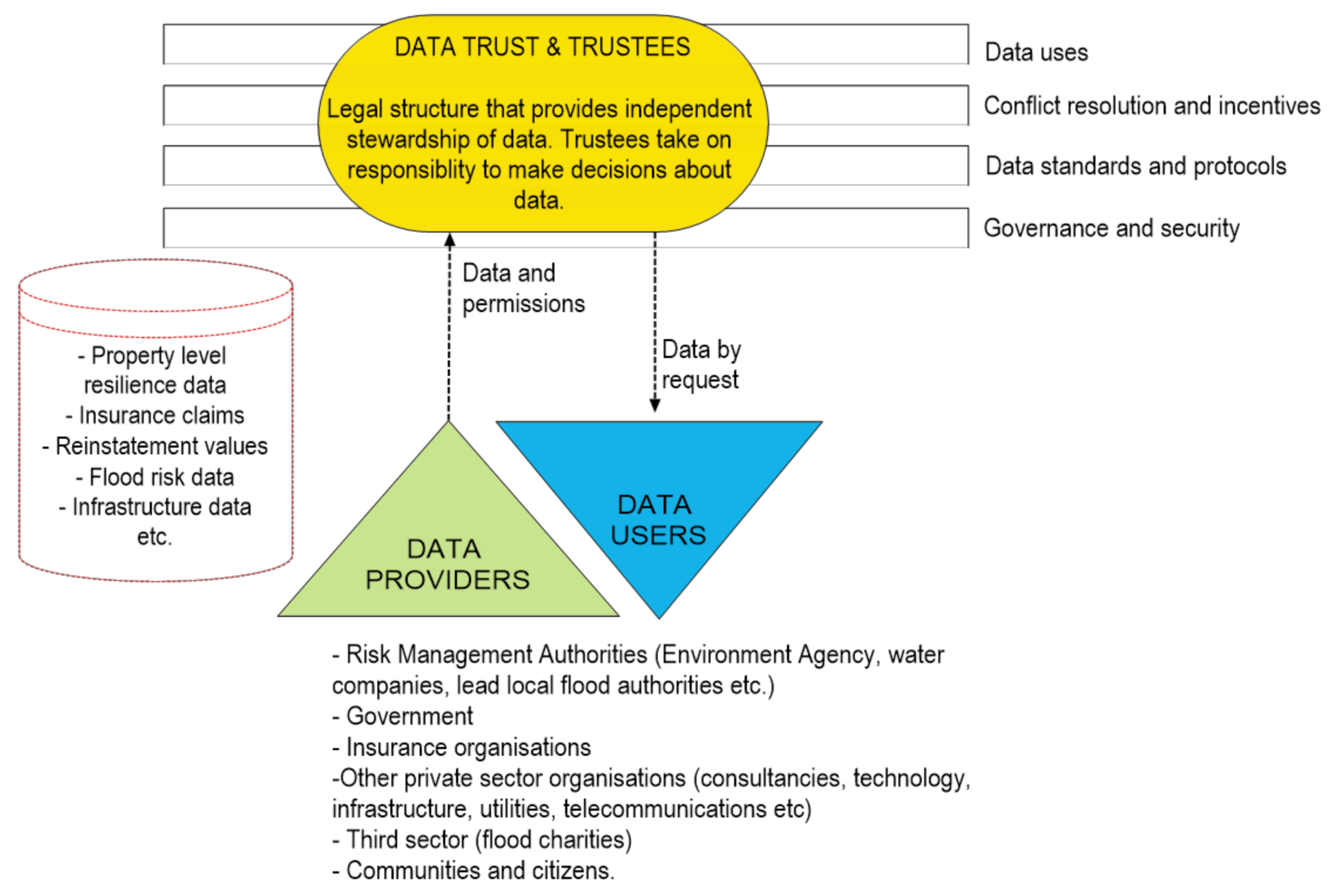
Key stakeholders across the domain of flooding have achieved a certain level of integration and maturity when sharing data. Targets exist to move to a model of shared stewardship and increased integration, known as a “data trust” [48]. A data trust (Figure 1) can include data holders from private, public and third sectors. Additionally, data users can form part of the data trust. Public bodies, communities, citizens and consumers come together to decide how to form a data trust. Organisations scope, co-design, launch, operate, evaluate and retire data trusts [47,48]. Organisations must overcome barriers to data sharing while retaining public trust (Table 1). Data trusts must align on areas such as data quality, governance and technological solutions to relax data sharing restrictions [46].
Within the context of flood risk management, there is a need to understand the challenges and barriers around sharing data across organisations from different sectors so that plausible solutions can be engineered. As it stands, there is a recognition of technical and non-technical barriers, along with potential resolutions such as standardisation of data models and technologies that improve accessibility. However, a comprehensive understanding of where these barriers exist is undocumented to date. Recent studies have reported barriers around standardisation of data collection and processing techniques for flood management practices [49]. Recent international examples of data trusts have focused on policy frameworks and governance structures. Examples include recent proposals from governments in India [50], Canada [51] and the European Union [52]. These comprise a legislative framework to govern data, overseen by a data trust. The intent of such proposals is to rebalance power in the data economy, in particular to provide additional protections to personal data and to enable individuals to exercise their data rights. Such moves provide a foundation to increase data sharing of non-personal data. The scope of such proposed governance structures extends beyond the domain of flooding. International efforts to establish a legal basis for data sharing provide a useful indication for the flood resilience community. More broadly, the World Bank has led the establishment of open data for developing nations, particularly related to enabling nations to achieve the UN Sustainable Development Goals. Such efforts to share open data underline the need for an approach that is distinct to the needs of individual nations. Additionally, the need to have a separate approach for non-personal data, where restrictions are typically lower. In [5], the importance for standardised practices for disaster anticipation and resilience is further recognised by UK Government within the context of hazard event forecasting. In this paper, we contribute to address this gap in knowledge. We used a mixed-methods approach to identify these barriers and evaluate the potential of establishing a data trust for geospatial and flood resilience data. We revised and classified data and technologies used to gather, process and share geospatial and resilience flood data. We compared stakeholders’ use of geospatial and flood resilience data and potential barriers around data sharing capacity, skills, tools and privacy. Finally, we discussed key findings and recommendations in a technological, economic, regulatory and social context.
2. Mixed-Methods Survey
2.1. Survey Design and Participant Selection
We selected a mixed-methods approach to obtain both quantitative and qualitative data in an inductive way. We obtained information from private, public and third sectors. The novel use of this approach in this domain helped us to corroborate findings, provide a well-rounded picture and add further insights that would not have been obtained through a single method [53]. We were able to gain a better understanding of the interconnections between organisations with this approach than with more traditional methods [54,55]. We also gained a better understanding of the links and contradictions between both qualitative and quantitative data [54].
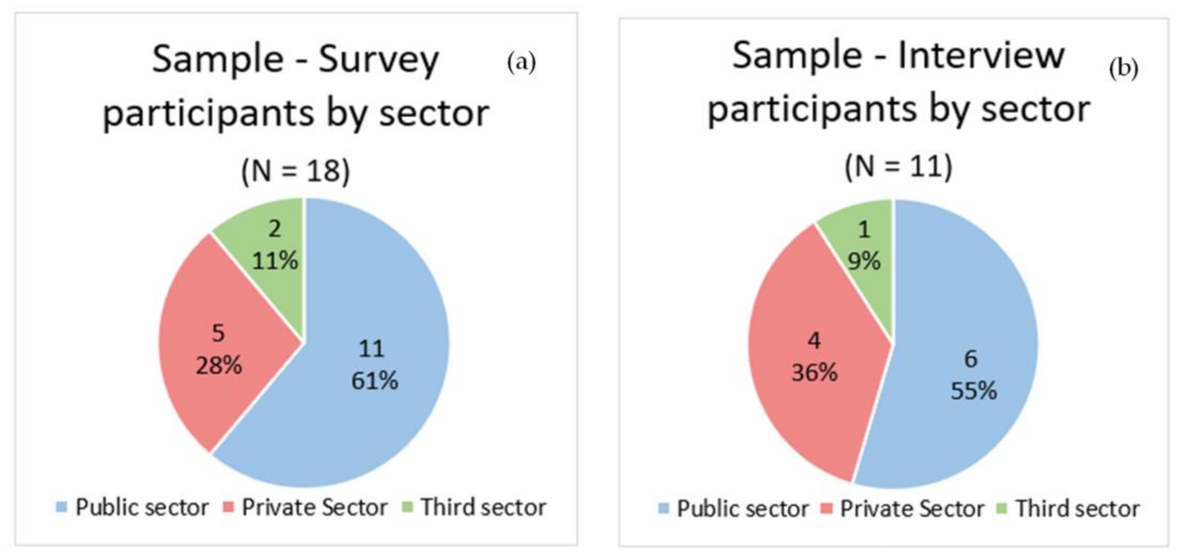
The domain of flooding is complex with regard to different practices and activities, subfields, the role of technology and data and the diversity of stakeholders. The number of stakeholders that play a role in flood data handling and processing is vast and varied. To ensure representative views across all three sectors were captured, representatives of key institutions (15) and players (18) were selected for participation. Selection was based on a systematic review of the literature and the identification of key organisations through a number of focused discussions. A bias towards public- and private-sector organisations was intentionally applied due to the progressive role they play in managing data in the UK. From the public sector, the selection included water companies, local authorities and key government agencies. From the private sector, the selection included catastrophe modelling consultancies, flood management technology industries, insurance companies, re-insurance companies and environmental consultancies. Participants from the third sector included two flood charities from England and Scotland that work to improve flood resilience in communities.
We gathered results from an initial online survey of participants, followed by a series of in-person interviews. The initial survey consisted of 19 questions (approx. 15 min to complete) and used a 10-point scale for the responses. We included open-ended questions that required a qualitative response to provide context. The in-person interviews drew findings from a one-hour semi-structured interview. These enabled comparison across stakeholders and uncovered previously unknown factors [54,55]. One-to-one interviews were used (rather than focus groups) to enable an exploration of different perspectives [56]. We used the survey and in-person responses to assess the barriers to sharing geospatial and flood resilience data. We anonymised all responses and stored the results on a networked drive. The data was only accessible by authorised users, in line with the Data Protection Act (2018).
2.2. Data Analysis
We aggregated quantitative survey data with across respondents from the public, private and third sectors and represented with descriptive statistics to enable a comparison of key themes specified in the research objectives such as organisational characteristics, technological barriers and data sharing. More specifically, bar plots were used to identify the range and spread of answers within sectors. We systematically coded and analysed interview data to provide a basis for emerging patterns across key topics, causes/explanations, relationships and emerging concepts [57].
A total of 18 participants contributed to the online survey and, from those, 11 participated in the interview (Figure 2). Participant responses highlighted a range of data types in use. Examples include property resilience data, weather and rainfall data, geographic data, citizen science data and Ordnance Survey data.
3. Results
3.1. Responses on Data Accuracy and Availability
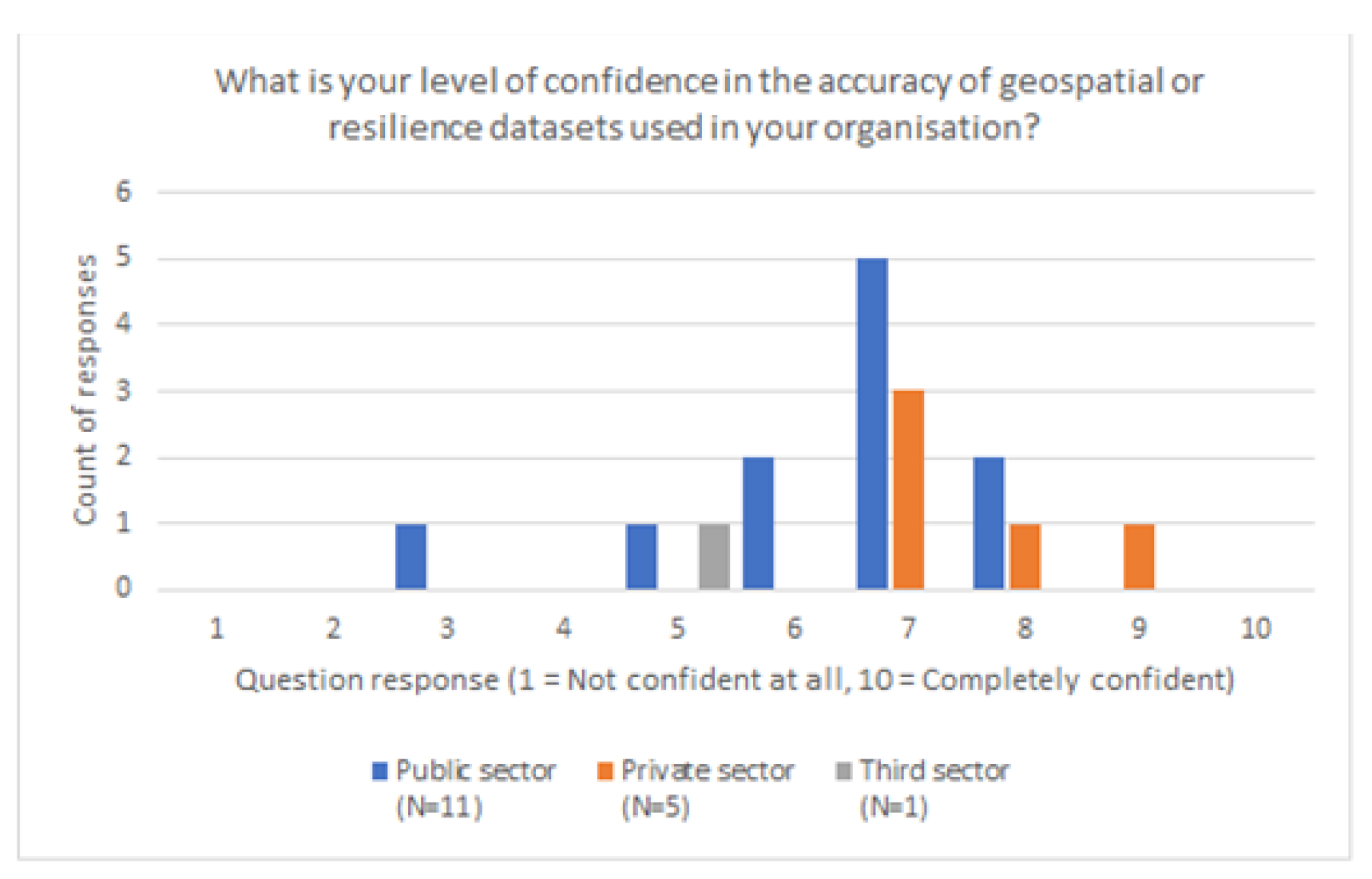
We found that private-sector organisations had higher confidence in their data compared with the public and third sectors (Figure 3). This indicated either differences in perceived data value across organisations, or an actual variation in data quality. During in-person interviews, public-sector participants highlighted resource constraints. There were doubts about the accuracy of large-scale flood risk modelling and mapping at property level. Access to property data such as construction type and year of build was problematic. The quality of flood resilience data was felt to be poor. Private-sector participants tended to have high confidence in data from trusted institutions such as the Environment Agency or the Met Office. There was also high confidence in commercially available catastrophe models.
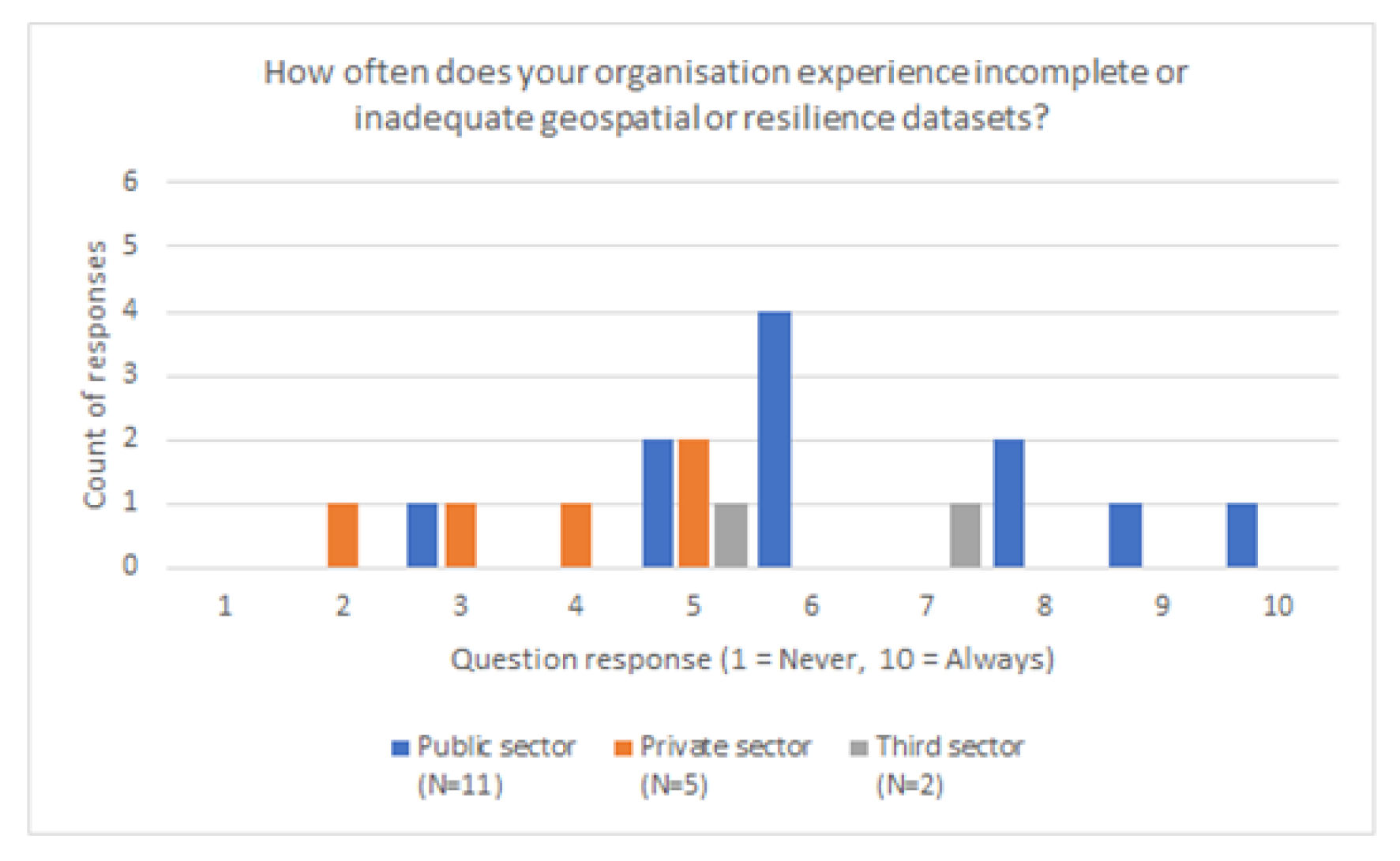
Participants from the public and third sectors emphasised incomplete or poor-quality data sets (Figure 4). Incomplete data sets included property data, insurance loss data and key areas such as utilities. Participants highlighted concerns around the accuracy of modelled flood warnings. Restrictions on sensitive data increased the impact of incomplete data sets.
3.2. Responses on Data Sharing Barriers
Participants from the public sector highlighted data sharing issues. Concerns included implications of sharing data to the private sector, where adverse outcomes around insurance could arise (Figure 5). Context and communication were outlined, particularly the need to move from sharing flood risk towards recommending actions. Participants from the private sector highlighted competition law. These restricted activities relating to insurance pricing. Additional restrictions around governance and security resulted in data sharing barriers, particularly when the potential impact was high.
Participants from the private sector highlighted constraints around privacy and ownership barriers (Figure 6). Participants from the private and public sectors mentioned constraints around GDPR the most. Time needed to cleanse and anonymise data was burdensome. Obtaining consent from data owners and members of the community to share data added additional delays. Participants from the third sector raised concerns about the use of public data for commercial purposes (such as flood risk maps). Private-sector organisations were less transparent about their flood risk data than those in the public sector.
Participants from the public sector expressed a high appetite to share data (Figure 7). There was a desire to increase public engagement to improve communication, particularly to begin a dialogue on positive resilience action, rather than furthering understanding of flood risk. There was appetite to increase data sharing with the insurance industry. Perceived benefits were to support economic evaluations on the costs of flood and the development of flood schemes. There was a willingness to share resilience data with insurers to improve insurance outcomes for communities. Lastly, there was appetite to improve collaboration and relationships with water companies in England.
Participants from the third sector were happy to share data with other public-sector organisations. The public interest of data sharing was valued highly. Data sharing with the private sector in contrast, was less valued and more risk averse as a result. There was a desire to increase data sharing across sectors to support an overarching view of flood, property values and resilience measures.
The survey results highlighted numerous challenges across sectors that limit the sharing and use of data. In the public sector, there were challenges around resilience data for property flood resilience schemes and overcoming resource constraints. The private sector experienced difficulties acquiring reliable data and using large datasets to model flood risk to properties. Inaccuracies and gaps in data between sectors create unaligned perceptions of risk and resilience. This directly affects third-sector organisations and communities that support those at high flood risk. We assessed the possibility of a data trust for geospatial and flood resilience data, based on our results.
4. Discussion
4.1. A Data Trust for Geospatial and Flood Resilience Data—Findings from a Mixed-Methods Survey
The domain of flooding in the UK is a complex environment, with many differing stakeholders looking to achieve various outcomes across the public, private and third sectors. Many organisations have adopted differing and divergent sharing mechanisms and contractual arrangements to share and attain value from geospatial and resilience data across various areas of society and markets. As a result, certain issues and barriers are prevalent across stakeholders that have a high interest in flooding.
In this paper, we evaluated the possibility of a data sharing trust for geospatial and flood resilience data in the UK that could address such barriers and limitations. We found that incentives may be required to encourage the private sector to share data and to invest in data quality. Additionally, that a consistent data standard can unlock value from sensitive location data. We find the public sector should become more effective in collecting and sharing data. This should include the removal of restrictive licenses where possible, with an increased move towards open data sets. Such data should be standardised, linked and publicly accessible.
We found that different top-down and bottom-up approaches to data collection must reflect the complexity of public and private-sector organisations. In particular, technology should be used in a decentralised way, to ensure public trust in data. A data trust would enable the sharing of sensitive personal data that is subject to GDPR privacy constraints. This can reassure third-sector organisations and provide a platform to enable the sharing of sensitive personal data.
We found that there are difficulties sharing large datasets. Substantial amounts of missing data results in uncertainty for data users. This can have implications for the communication of flood risk to communities, particularly when there is inadequate information across spatial and temporal scales. This can lead to inadequate responses during flood events. A data trust could reduce this gap and enable further reconciliation between top-down and bottom-up approaches. This could improve community resilience and flood risk communication. The benefits of a data trust could extend to private-sector start-ups. Innovation in this sector could help to reconcile the gap between organisations and local communities.
Our findings can be used to support the flood community internationally. Nations that have already embarked on work to establish data trusts such as India [50] Canada [51] and the EU [52] should develop approaches to data sharing between public- and private-sector organisations. Where such frameworks do not currently exist, the flood community should establish links to organisations such as the World Bank. This would increase the impact of data studies and provide a link to real-world applications and benefits.
4.2. Lessons to Draw from and Steps to Follow
We believe that the work presented here highlights the initial steps (Table 2) for a data trust for geospatial and flood resilient data. We have grouped the lessons learnt from our study into four steps: (i) increase trust in data, (ii) manage data restrictions, (iii) increase data transparency and (iv) develop a focused communication strategy.
Trust in data will be achieved when goals within and between organisations are aligned and measured through a set of publicly available performance and impact metrics. Part of the process will require raising awareness to increase engagement and train experts to confidently calculate these metrics and use the data. This will lead the way to the development of standardised data collection and processing practices and specific data quality, quantity and accuracy criteria. In turn, this will improve gaps of data quality between sectors and increase data value. We believe that these standards will define a common understanding of “completeness” for geospatial and flood resilient data. The standardised practices would be adopted as a best code of practice by organisations or enforced through policy and regulation.
Management of data restrictions will require an in-depth analysis of data interdependencies between and within organisations. This is in addition to the exact restrictions that govern different data sets. We propose the development of harmonised agreements that reach an international consensus on data sharing [58] and encourage compliance. This will define the relationship between data providers and data users. We also encourage international initiatives to define data sharing standards, similar to EU-STANDS4PM [59]. We agree with the Open Data Institute [59] that geospatial data stewards should be encouraged and restrictive licenses removed. Openly licensed datasets should be standardised through identifies and registers. This would make it possible to easily link disparate datasets. We believe that such foundations would enable the creation of innovative business models in the public and private sectors. For example, by charging for services such as streamlined API access, specialised data collection, support and consultancy.
We believe that increased transparency requires easily accessible architectures that clearly identify how data sets were collected, their data owners and the changes the data sets have endured during their lifecycle. This is in addition to the description of the data quality, quantity, accuracy and completeness as described in previous paragraphs. The UK is at the forefront on governmental architectures for public data sharing strategies and Open Data repositories (e.g., UK Open Data portal [60]). Therefore, it could be a leading example on the generation of a flood data trust. Financial incentives may be required to encourage the private and third sectors to obtain and process data following pre-determined protocols and to make data sets available through specified architectures. Similarly, there may be a need to invest in the creation of decentralised data hubs.
We suggest the development of improved communication strategies that (i) clearly convey the use of specific data sets to generate recommendations for flood resilience action and (ii) increase data value perceptions. We suggest that the principles of the Adaptive Protection Motivation Theory (APMT) are used [61]. The APMT takes into account different sources of behavioural bias to identify communication strategies that increase flood resilience protection. Results in [61] suggested that strategies are most effective when they accurately capture the decision-making process of end users.

Table 2.
Proposed steps and actions to develop a data trust for geospatial and flood resilient data.
Table 2.
Proposed steps and actions to develop a data trust for geospatial and flood resilient data.
| Steps | Proposed Action |
|---|---|
| Increase trust in data | Align public-, private- and third-sector goals Develop publicly available performance and impact metrics Train experts to calculate metrics Develop standardised data collection and processing practices Train experts to apply standards Policy and regulatory execution of standards |
| Effective management of data restrictions | Identify data interdependencies Identify restrictions within and between organisations Development of an harmonised agreement for international data sharing [58] Removal of restrictive licenses Invest in publicly available open data sets |
| Increase transparency | Data repository for flood data Designate trusted Institutions to run the data repositories Financial incentives to align with regulatory standards Facilitate technological integration Financial incentives to pilot technologies for data collection, processing and sharing |
| Improve communication strategy | Use the Adaptive Protection Motivation Theory to develop effective communication strategies [61]. |
Our results are consistent with those obtained by other authors in similar studies. In Vietnam, Ngo Thu and When [62] looked at the Vietnamese perspective on data sharing in international transboundary contexts for the Lower Mekong Basin. Their research identifies the drivers and obstacles influencing hydrological and water related information sharing in the Vietnam National Mekong Committee (Cambodia, Lao PDR, Thailand and Vietnam) and its line agencies. They highlight the Procedures for Data and Information Exchange Sharing (PDIES) [63] ratified in 2001 has some limitations, including lack of data completeness, poor data quantity/quality (classed as merely acceptable), insufficient participation of skilled participants in addition to information systems failing to communicate information to end users. Other limitations included the lack of clear national regulations for cross-nation data sharing, lack of policy coherence, lack of clear data request guidelines, lack of modern systems for data management (technology uptake), missing regulations on data definitions, format and exchange frequency, in addition to limitations on ensuring data confidentiality. The authors also found that willingness to share data depends on the type of data. Environmental data, for example, is easy to share whereas extraction of hydrological parameters is challenging. However, they recognise that PDIES is a step in the right direction and has increased transparency of information. Sock et al. [64] further highlights that lack of institutional regulatory authority has resulted in partial failure of PDIES data sharing arrangements. Mukuyu et al. [65] identified factors that promote exchange in shared waters and highlighted the importance of formalised data-exchange protocols and the adoption of online platforms to promote data exchange across 25 international river basins. Surminiski [66] reports that improvements in access to and use of high-quality data and transparency about risk are needed in Ireland to enhance flood protection. The author reports the need for a data platform that aids a collaborative approach to understanding flood risk and resilience. She further reports the need to apply a broad approach that includes data from different sectors (e.g., banks, property developers, utility companies) to increase transparency and trust. Surminiski [66] envisages a data platform that addresses challenges around commercial sensitive and data protection, finds a common format and tools to translate data from different stakeholders, facilitates visualisation and ease of access, promotes and requires the use of the platform, minimises timing problems and links to other existing tools. Much of these principles align with the needs we have identified for our data trust within a different international context.
4.3. Areas for Further Consideration
We considered the international imperative to increase data sharing between organisations as an enabler to climate change adaptations. We assessed the limitations to data sharing are in a UK context. We found that barriers are primarily between private- and public-sector organisations. This is particularly relevant for other regions of the world, where data sharing is not common. However, international tensions and the need to secure scarce water supplies could reduce the desire to achieve this in practice.
We evaluated the potential for a data trust based on a small sample of geospatial and flood resilience data. However, a wider sample is needed to capture a greater number of the flood stakeholders. This could include a wider set of stakeholders, with a similar mixed-methods approach. Stakeholders could include government departments, wider local authorities, water companies and private-sector industries such as infrastructure.
Engagement across key stakeholders and data owners should take place to initiate work on defining key elements of a data trust. Discussions with similar projects/institutions such as the Open Data Institute (ODI) and the Data and Analytics Facility for National Infrastructure (DAFNI) can build on lessons learnt previously to establish cross-sector partnerships and sharing data. Additionally, engaging with institutions (e.g., Zurich Flood Resilience Alliance) can build on lessons learnt and inform the forward technological requirements. Support from research institutions can help to test frameworks and collect and analyse data on community resilience.
Considerations should include the legal structure, ideal trustees and data stewards, data protocols and standards. There should be a timeline to define and operationalise the data trust and to realise benefits aligned to flooding. Finally, adequate investment and tender opportunities for data projects in rural and vulnerable communities would encourage further private-sector engagement and innovation.
We acknowledge that the results here presented are biased towards the public and private sector. We understand that there is a need to better map the third sector. Similarly, we acknowledge that within company data sharing barriers have not been explored and should be the focus of further research. We understand that there is a need to better map the specific data types used, their interdependencies between and within companies, and the mechanisms by which these are shared before more solid conclusions can be established. However, we presented results that are representative of the flood data landscape for key players at national (UK) level. This is the first study of this type applied to UK flood data and organisations. Further research should focus on characterising flood data interconnections, data sharing barriers as well as data sharing solutions at a finer resolution (e.g., within organisations). This will enable the integration of findings and identification of solutions that facilitate data sharing at different organisational scales (i.e., within and between organisations). We have established the link to the international flood data context through a review of recent scientific publications. We believe that the differences between countries identified in this paper highlight the varied range of barriers, limitations and stoppers present across countries. With river catchments and associated flooding spanning across multiple countries, there is also a need to build our capability to share data and data transferability lessons across countries. We believe that further research should focus on (i) the development and implementation of a systematic data collection and analytical approach that enables in-depth cross-country comparison and (ii) the development of effective mechanisms for international data sharing. These findings are consistent with the need for international data sharing reported by other authors [67,68].
5. Conclusions
We outlined a framework for sharing and improving accessibility to open flood data across public, private and third sectors. We identified emergent data and technologies that can enable the UK’s data economy. We find there are currently barriers and constraints (technological, security, privacy, cultural and commercial) around sharing geospatial and flood resilience data. We conducted a mixed-methods survey to evaluate differences across sectors and inform recommendations going forward. We outlined how improved data sharing and data accessibility can support organisations and communities.
We found that there is recognition of technical and non-technical barriers, along with potential resolutions such as standardisation of data models and technologies than improve accessibility. Some of these barriers are driven by the different contractual arrangements and sharing mechanisms adopted by different institutions. This paper contributes to addressing these needs through contextualising challenges to data sharing to the field of flood risk management. We have suggested four steps to be prioritised to initiate a geospatial and resilient flood data trust: (i) increase trust in data, (ii) manage data restrictions, (iii) increase data transparency and (iv) develop a focused communication strategy.
To summarise, the main achievements of this study are to identify that clear differences in expectations and experiences exist between the private and public sectors. Geospatial and resilience data frequently require specialist skills. Where these are lacking, trust in the data reduces. We have set out ways to overcome this, principally through a formal data trust as well as more holistically, by engaging with key stakeholders to understand the needs and barriers around data. We believe that our study has wider lessons for the international context. Nations are at different stages in their data development. We identify that a tailored approach should be considered that incorporates this, in particular the need to balance the private and public sectors, alongside the protection of data rights for individuals. Examples of tensions where rivers cross international boundaries highlight the potential for water conflicts. Therefore, we believe that data sharing and trust have never been more vital, and must underpin a successful adaptation to climate change. The research contributes to the academic literature in the area of open flood data provision and accessibility.
Author Contributions
Conceptualization, L.W., M.R.C., E.B. and G.M.; methodology, L.W., M.R.C., E.B. and G.M.; software, L.W.; validation, L.W.; formal analysis, L.W.; investigation, L.W.; resources, E.B. and G.M.; data curation, L.W.; writing—original draft preparation, L.W.; writing—review and editing, L.W., M.R.C., E.B. and G.M.; visualisation, L.W.; supervision, M.R.C., E.B. and G.M.; project administration, M.R.C.; funding acquisition, M.R.C., E.B. and G.M. All authors have read and agreed to the published version of the manuscript.
Funding
This research was funded by Flood Re.
Institutional Review Board Statement
The study was conducted according to the guidelines of the Declaration of Helsinki, and approved by the Ethics Committee of Cranfield University (Cranfield University Research Ethics System (CURES) 27/05/20).
Informed Consent Statement
Informed consent was obtained from all subjects involved in the study.
Data Availability Statement
The underlying data are sensitive and cannot be shared due to a permanent embargo.
Acknowledgments
A total of eighteen representatives from numerous organisations in the public, private and third sectors participated in this study. We would like to sincerely express our thanks to all of those who were generous with their time. We would also like to thank the reviewers; their dedicated feedback and comments guided the manuscript to publishable standards.
Conflicts of Interest
The authors declare no conflict of interest.
References
- Taylor, P.; Cox, S.; Walker, G.; Valentine, D.; Sheahan, P. WaterML2.0: Development of an open standard for hydrological time-series data exchange. J. Hydroinform. 2014, 16, 425–446. [Google Scholar] [CrossRef] [Green Version]
- Deltares. Global Data and Tools for Flood Risk Assessment. Available online: https://www.deltares.nl/en/issues/global-data-tools-flood-risk-assessment/ (accessed on 4 April 2021).
- European Environment Agency. European Floods Database. Available online: https://www.eea.europa.eu/data-and-maps/data/external/european-floods-database (accessed on 4 April 2021).
- Hall, J.; Arheimer, B.; Aronica, G.T.; Bilibashi, A.; Boháč, M.; Bonacci, O.; Borga, M.; Burlando, P.; Castellarin, A.; Chirico, G.B.; et al. A European flood database: Facilitating comprehensive flood research beyond administrative boundaries. Proc. IAHS 2015, 370, 89–95. [Google Scholar] [CrossRef] [Green Version]
- Hughes, R.; Murray, V.; Royse, K. CR19: Data Sharing. 2012. Available online: https://assets.publishing.service.gov.uk/government/uploads/system/uploads/attachment_data/file/287471/12-1306-data-sharing.pdf (accessed on 24 April 2021).
- Ghosh, N.; Bandyopadhyay, J.; Sayanangshu, M. China-India data sharing for early flood warning in the Brahmaputra: A critique. ORF Issue Brief 2019, 328, 1–16. Available online: https://www.orfonline.org/wp-content/uploads/2019/12/ORF_IssueBrief_328_India-China-Brahmaputra.pdf (accessed on 24 April 2021).
- Procon.org. 1995 Oslo Interim Agreement. Available online: https://israelipalestinian.procon.org/background-resources/1995-oslo-interim-agreement/ (accessed on 4 April 2021).
- Carter, N.T.; Mulligan, S.P.; Seelke, C.R. U.S.-Mexican Water Sharing: Background and Recent Developments; Congressional Research Service: USA, 2017.
- Ward, E.; Buytaert, W.; Peaver, L.; Wheater, H. Evaluation of precipitation products over complex mountainous terrain: A water resources perspective. Adv. Water Resour. 2011, 34, 1222–1231. [Google Scholar] [CrossRef]
- Global Flood Monitor. Available online: https://www.globalfloodmonitor.org/ (accessed on 4 April 2021).
- OpenEarth. Available online: https://www.openearth.nl/ (accessed on 4 April 2021).
- Edina. Digimap. 2018. Available online: https://digimap.edina.ac.uk/ (accessed on 4 April 2021).
- Admiralty. Marine Data Portal. Available online: https://datahub.admiralty.co.uk/portal/apps/sites/#/marine-data-portal (accessed on 4 April 2021).
- United Nations Institute for Training and Research. Maximizing Our Impact Through Data Sharing: UNOSAT Flood Portal. Available online: https://unitar.org/about/news-stories/news/maximizing-our-impact-through-data-sharing-unosat-flood-portal (accessed on 24 April 2021).
- European Commission. Inspire Geoportal. Available online: https://inspire-geoportal.ec.europa.eu/ (accessed on 24 April 2021).
- European Union. Directive 2007/60/EC of the European Council and European Parliament of 23 October 2007 on the assessment and management of flood risks. Off. J. Eur. Union 2007, 2455, 27–34. Available online: http://eur-lex.europa.eu/legal-content/EN/TXT/PDF/?uri=CELEX:32007L0060&from=EN (accessed on 24 April 2021).
- European Union. Directive 2000/60/EC of the European Parliament and of the Council of 23 October 2000 establishing a framework for Community action in the field of water policy Official journal. Off. J. Eur. Union 2000, 43, 1–83. Available online: https://eur-lex.europa.eu/legal-content/EN/TXT/?uri=CELEX:32000L0060&from=EN (accessed on 24 April 2021).
- EurEea. The Governance of Water Services in Europe—2020 Edition. 2020. Available online: https://ncdc.gov.ng/themes/common/docs/protocols/111_1579986179.pdf (accessed on 24 April 2021).
- Ofwat. We Regulate the Water Sector in England and Wales. Available online: https://www.ofwat.gov.uk/ (accessed on 4 April 2021).
- Nielsen, E.; Ong, A. Economic Impacts of COVID-19 on the Water Sector; Frontier Economics: London, UK, 2020. [Google Scholar]
- Barrowclough, D. Public Banks and COVID-19. 2020. Available online: https://publicbankscovid19.org/images/PDF_FILES/Public_Banks_and_Covid19_-_Full_Book.pdf#page=294 (accessed on 24 April 2021).
- World Bank. Supporting Water Utilities during COVID-19. 2020. Available online: https://www.worldbank.org/en/news/feature/2020/06/30/supporting-water-utilities-during-covid-19 (accessed on 4 April 2021).
- Committee on Climate Change. UK Climate Change—Risk Assessment 2017; HM Government: London, UK, 2017; p. 24. Available online: https://assets.publishing.service.gov.uk/government/uploads/system/uploads/attachment_data/file/584281/uk-climate-change-risk-assess-2017.pdf (accessed on 24 April 2021).
- Environment Agency. Estimating the Economic Costs of the 2015 to 2016 Winter Floods; Environment Agency: Bristol, UK, 2018. [Google Scholar]
- Department for Environment Foodand Rural Affairs (DEFRA). The National Adaptation Programme and the Third Strategy for Climate Adaptation Reporting; Department for Environment, Food and Rural Affairs: London, UK, 2018.
- Department for Environment Food and Rural Affairs (DEFRA). UK Climate Change Risk Assessment; HM Government: London, UK, 2017.
- Department for Environment Food and Rural Affairs (DEFRA). Call for Evidence on Flooding and Coastal Erosion Policy; Department for Environment, Food and Rural Affairs: London, UK, 2019.
- Environment Agency. What Is the Risk of Flooding from Surface Water Map; Environment Agency: Bristol, UK, 2019. [Google Scholar]
- National Infrastructure Commission. National Infrastructure Assessment 2018; National Infrastructure Commission: London, UK, 2018; p. 160. Available online: https://www.nic.org.uk/publications/national-infrastructure-assessment-2018/ (accessed on 24 April 2021).
- Department for Environment Food and Rural Affairs (DEFRA). Flood and Coastal Erosion Risk Management Policy Statement; HM Government: London, UK, 2020.
- Zurich Flood Resilience Alliance. The Flood Resilience Measurement for Communities; Zurich Flood Resilience Alliance: Zürich, Switzerland, 2019. [Google Scholar]
- Arshad, B.; Ogie, R.; Barthelemy, J.; Pradhan, B.; Verstaevel, N.; Perez, P. Computer vision and IoT-based sensors in flood monitoring and mapping: A systematic review. Sensors 2019, 19, 12. [Google Scholar] [CrossRef] [Green Version]
- Mourato, S.; Fernandez, P.; Pereira, L.; Moreira, M. Improving a DSM obtained by unmanned aerial vehicles for flood modelling. IOP Conf. Ser. Earth Environ. Sci. 2017, 95. [Google Scholar] [CrossRef]
- Saravi, S.; Kalawsky, R.; Joannou, D.; Casado, M.R.; Fu, G.; Meng, F. Use of artificial intelligence to improve resilience and preparedness against adverse flood events. Water 2019, 11, 973. [Google Scholar] [CrossRef] [Green Version]
- Edwards, L.; Mullagh, L.; Towe, R.; Nundloll, V.; Dean, C.; Dean, G.; Simm, W.; Samreen, F.; Bassett, R.; Blair, G. Data-driven decisions for flood risk management. Zenodo 2017. [Google Scholar] [CrossRef]
- Cheung, W.; Feldman, D. Can citizen science promote flood risk communication? Water 2019, 11, 1961. [Google Scholar] [CrossRef] [Green Version]
- Sy, B.; Frischknecht, C.; Dao, H.; Consuegra, D.; Giuliani, G. Flood hazard assessment and the role of citizen science. J. Flood Risk Manag. 2019, 12, 1–14. [Google Scholar] [CrossRef]
- Assumpção, T.H.; Popescu, I.; Jonoski, A.; Solomatine, D.P. Citizen observations contributing to flood modelling: Opportunities and challenges. Hydrol. Earth Syst. Sci. 2018, 22, 1473–1489. [Google Scholar] [CrossRef] [Green Version]
- McClymont, K.; Morrison, D.; Beevers, L.; Carmen, E. Flood resilience: A systematic review. J. Environ. Plan. Manag. 2020, 63, 1151–1176. [Google Scholar] [CrossRef] [Green Version]
- Rollason, E.; Bracken, L.J.; Hardy, R.J.; Large, A.R.G. Rethinking flood risk communication. Nat. Hazards 2018, 92, 1665–1686. [Google Scholar] [CrossRef] [Green Version]
- Forrest, S.; Trell, E.M.; Woltjer, J. Flood groups in England: Governance arrangements and contribution to flood resilience. In Governing for Resilience in Vulnerable Places; Routledge: London, UK, 2017; pp. 92–115. [Google Scholar] [CrossRef]
- Fu, G.; Meng, F.; Rivas Casado, M.; Kalawsky, R.S. Towards integrated flood risk and resilience management. Water 2020, 12, 1789. [Google Scholar] [CrossRef]
- Digital Realty. Data Economy Report 2018; Digital Realty: San Francisco, CA, USA, 2018; p. 18. [Google Scholar]
- Pitelis, C. Industrial Strategy: For Britain, in Europe and the World. J. Econ. Stud. 1994, 21, 3–92. [Google Scholar] [CrossRef]
- Open Data Institute. The UK’s Geospatial Data Infrastructure: Challenges and Opportunities; Open Data Institute: London, UK, 2018. [Google Scholar]
- Geospatial Commission. Unlocking the Power of Location: The UK’s Geospatial Strategy; HM Government (Unlocking the Power of Location: The UK’s Geospatial Strategy—GOV.UK): London, UK, 2020. [Google Scholar]
- National Infrastructure Commission. Data for the Public Good; National Infrastructure Commission: London, UK, 2017; p. 76, Available online: https://www.nic.org.uk/wp-content/uploads/Data-for-the-Public-Good-NIC-Report.pdf%0A; https://www.nic.org.uk/publications/data-public-good/; (accessed on 24 April 2021). [Google Scholar]
- Open Data Institute. Data Trusts Summary Report. 2019. Available online: https://theodi.org/wp-content/uploads/2019/04/ODI-Data-Trusts-A4-Report-web-version.pdf (accessed on 24 April 2021).
- Casado, M.R.; Leinster, P. Towards more effective strategies to reduce property level flood risk: Standardising the use of unmanned aerial vehicles. J. Water Supply Res. Technol. AQUA 2020, 69, 807–818. [Google Scholar] [CrossRef]
- Ministry of Electronics and Information Technology—Government of India. Report by the Committee of Experts on Non-Personal Data Governance Framework; Ministry of Electronics and Information Technology: New Delhi, India, 2020.
- Ontario News. Ontario Launches Consultations to Strengthen Privacy Protections of Personal Data. Available online: https://news.ontario.ca/en/release/57985/ontario-launches-consultations-to-strengthen-privacy-protections-of-personal-data (accessed on 4 April 2021).
- European Commission. Communication “A European Strategy for Data”; European Commission: Brussels, Belgium, 2020. [Google Scholar]
- Bryman, A. Integrating quantitative and qualitative research: How is it done? Qual. Res. 2006, 6, 97–113. [Google Scholar] [CrossRef] [Green Version]
- Tashakkori, A.; Creswell, J.W. Exploring the nature of research questions in mixed methods research. J. Mix. Method Res. 2007, 1, 207–211. [Google Scholar] [CrossRef]
- Johnson, R.B.; Onwuegbuzie, A.J. Mixed methods research: A research paradigm whose time has come. Educ. Res. 2004, 33, 14–26. [Google Scholar] [CrossRef] [Green Version]
- Gill, P.; Stewart, K.; Treasure, E.; Chadwick, B. Methods of data collection in qualitative research: Interviews and focus groups. Br. Dent. J. 2008, 204, 291–295. [Google Scholar] [CrossRef] [PubMed]
- Walliman, N. Research Methods: The Basics, 1st ed.; Taylor & Francis: Milton, MA, USA, 2010; Available online: https://www.taylorfrancis.com/books/mono/10.4324/9780203836071/research-methods-basics-nicholas-walliman (accessed on 24 April 2021).
- Saulnier, K.M.; Bujold, D.; Dyke, S.O.M.; Dupras, C.; Beck, S.; Bourque, G.; Joly, Y. Benefits and barriers in the design of harmonized access agreements for international data sharing. Sci. Data 2019, 6, 2–7. [Google Scholar] [CrossRef] [Green Version]
- EU-STANDS4PM. A European Standardization Framework for Data Integration and Data-Driven in Silico Models for Personalised Medicine. Available online: https://www.eu-stands4pm.eu/ (accessed on 4 April 2021).
- GOV.UK. Find Open Data. Available online: https://data.gov.uk/ (accessed on 4 April 2021).
- Oakley, M.; Himmelweit, S.M.; Leinster, P.; Casado, M.R. Protection motivation theory: A proposed theoretical extension and moving beyond rationality-the case of flooding. Water 2020, 12, 1848. [Google Scholar] [CrossRef]
- Thu, H.N.; Wehn, U. Data sharing in international transboundary contexts: The Vietnamese perspective on data sharing in the lower Mekong basin. J. Hydrol. 2016, 536, 351–364. [Google Scholar] [CrossRef] [Green Version]
- Mekong River Commission. Procedures for Data and Information Exchange and Sharing (PSIES). 2001. Available online: https://data.opendevelopmentmekong.net/dataset/51b083e3-9129-47c1-a06d-047e3ae3be58/resource/b723ca05-9f99-44b3-b4e1-fbe7c4b8efc9/download/procedures-data-info-exchange-n-sharing.pdf (accessed on 24 April 2021).
- Sok, S.; Meas, S.; Chea, S.; Chhinh, N. Regional cooperation and benefit sharing for sustainable water resources management in the lower Mekong basin. Lakes Reserv. Res. Manag. 2019, 24, 215–227. [Google Scholar] [CrossRef]
- Mukuyu, P.; Lautze, J.; Rieu-Clarke, A.; Saruchera, D.; McCartney, M. The devil’s in the details: Data exchange in transboundary waters. Water Int. 2020, 45, 884–900. [Google Scholar] [CrossRef]
- Surminski, S. Fit for the Future? The Reform of Flood Insurance in Ireland: Resolving the Data Controversy and Supporting Climate Change Adaptation; Policy Paper; The Centre for Climate Change Economics and Policy; The Grantham Research Institute on Climate Change and the Environment: London, UK, 2017. [Google Scholar]
- De Bruijn, J.A.; de Moel, H.; Jongman, B.; de Ruiter, M.C.; Wagemaker, J.; Aerts, J.C.J.H. A global database of historic and real-time flood events based on social media. Sci. Data 2019, 6, 1–12. [Google Scholar] [CrossRef]
- Messner, F.; Meyer, V. Flood damage, vulnerability and risk perception—Challenges for flood damage research. In Flood Risk Management: Hazards, Vulnerability and Mitigation Measures; Schanze, J., Zeman, E., Marsalek, J., Eds.; Springer: Dordrecht, The Netherlands, 2006; Volume 67. [Google Scholar] [CrossRef] [Green Version]
Figure 1.
Data trust in the context of flooding in the UK.

Figure 2.
Sample of participants for (a) surveys (b) and interviews.

Figure 3.
Number of responses per sector obtained for the following survey question: “What is your level of confidence in the accuracy of geospatial or resilience datasets used in your organisation?”.
Figure 3.
Number of responses per sector obtained for the following survey question: “What is your level of confidence in the accuracy of geospatial or resilience datasets used in your organisation?”.

Figure 4.
Number of responses per sector obtained for the following survey question: “How often does your organisation experience incomplete or inadequate geospatial or resilience datasets?”.
Figure 4.
Number of responses per sector obtained for the following survey question: “How often does your organisation experience incomplete or inadequate geospatial or resilience datasets?”.

Figure 5.
Number of responses per sector obtained for the following survey question: “How often do you encounter any barriers when sharing geospatial or resilience data with other organisations (provide with or receive)?”.
Figure 5.
Number of responses per sector obtained for the following survey question: “How often do you encounter any barriers when sharing geospatial or resilience data with other organisations (provide with or receive)?”.

Figure 6.
Number of responses per sector obtained for the following survey question: “How often does your organisation encounter constraints around privacy or ownership when sharing geospatial or resilience data with other organisations?”.
Figure 6.
Number of responses per sector obtained for the following survey question: “How often does your organisation encounter constraints around privacy or ownership when sharing geospatial or resilience data with other organisations?”.

Figure 7.
Number of responses per sector obtained for the following survey question: “What is your appetite for sharing geospatial or resilience data with other organisations (provide with or receive)?”.
Figure 7.
Number of responses per sector obtained for the following survey question: “What is your appetite for sharing geospatial or resilience data with other organisations (provide with or receive)?”.

Table 1.
Challenges preventing data sharing [47].
Table 1.
Challenges preventing data sharing [47].
| Challenge | Description |
|---|---|
| Security | Further measures need to be developed as a part of data sharing infrastructure to enable the sharing of sensitive data and manage the risk of loss. |
| Legal | Data is often shared within the parameters of existing contractual agreements, competition laws and intellectual property rights frameworks. |
| Privacy | The General Data Protection Regulation (GDPR) has continued to improve the rights of individuals when processing their personal data. |
| Technical | Coordination and the alignment of data models are required to overcome barriers such as the interoperability of data, inconsistent formats, availability, data quality or a lack of metadata. |
| Commercial | Companies treating data as confidential in order to protect their commercial model or competitiveness in the market. |
| Cultural | Risk-averse attitudes and siloed thinking towards sharing data across different sectors. |
Publisher’s Note: MDPI stays neutral with regard to jurisdictional claims in published maps and institutional affiliations. |
© 2021 by the authors. Licensee MDPI, Basel, Switzerland. This article is an open access article distributed under the terms and conditions of the Creative Commons Attribution (CC BY) license (https://creativecommons.org/licenses/by/4.0/).
Share and Cite
MDPI and ACS Style
Waterman, L.; Rivas Casado, M.; Bergin, E.; McInally, G. A Mixed-Methods Investigation into Barriers for Sharing Geospatial and Resilience Flood Data in the UK. Water 2021, 13, 1235. https://doi.org/10.3390/w13091235
AMA Style
Waterman L, Rivas Casado M, Bergin E, McInally G. A Mixed-Methods Investigation into Barriers for Sharing Geospatial and Resilience Flood Data in the UK. Water. 2021; 13(9):1235. https://doi.org/10.3390/w13091235
Chicago/Turabian StyleWaterman, Luke, Mónica Rivas Casado, Emma Bergin, and Gary McInally. 2021. "A Mixed-Methods Investigation into Barriers for Sharing Geospatial and Resilience Flood Data in the UK" Water 13, no. 9: 1235. https://doi.org/10.3390/w13091235
Note that from the first issue of 2016, this journal uses article numbers instead of page numbers. See further details here.