Wetland Utilization and Adaptation Practice of a Coastal Megacity: A Case Study of Chongming Island, Shanghai, China
 Junlin Bao1,2*
  Shu Gao3,4
- 1Institute of Chinese Historical Geography, Fudan University, Shanghai, China
- 2Center for Historical Geographical Studies, Fudan University, Shanghai, China
- 3State Key Laboratory of Estuarine and Coastal Research, East China Normal University, Shanghai, China
- 4School of Geographic and Oceanographic Sciences, Nanjing University, Nanjing, China
Coastal urban areas are faced with risks induced by global warming and sea level rise, which puts pressure on regional sustainable development. In particular, land use adjustment is closely related to climate change for a coastal megacity. Coastal wetlands on the edge of the megacity represent a vulnerable ecosystem and a key area in terms of the resilient adaptation strategy. However, the interrelationship between the development of these wetlands and the megacity’s adaptation practice has not been sufficiently analyzed. From a historical perspective, based on document synthesis and field investigation, we attempt in this study to reveal long-term land use stages and driving factors in association with urban marginal wetlands, with a special reference to eastern Chongming Island, Shanghai. On such a basis, the future adaptation strategy of the megacity is evaluated. The analytical results show that this island has witnessed three periods of time for wetland utilization: traditional land use for salt production, fishery and agriculture before 1950, industrialization with rapid reclamation during 1950–2001, and the land use pattern orientated toward wetland ecosystem protection after 2002. The driving forces include sediment budget on the coast, wetland morphodynamic processes, sea level rise, population growth, and resource management policy changes. Transformation occurred between the wetland utilization stages in response to the changes of these forces. Furthermore, facing future climate change, there are different options of adaptation, e.g., retreatment and adherence. It may not be suitable for coastal cities with a large population to take the first option. It will be suitable for coastal communities to adhere to the location, if solutions to the problems of flooding risk, coastal erosion, and the maintenance of coastal facilities can be found. For eastern Chongming wetlands, as a key experimental area for ecosystem-oriented development in Shanghai, the transformation from the reclamation-oriented utilization toward the protection of wetland ecosystems represents the first step toward the latter option. We suggest that the next steps would be to maintain the ecological niche of the wetlands, to create new approaches to coastal engineering with contributions from the ecosystem, and to provide better ecosystem services.
Introduction
Twenty three of the top 30 global big cities are located in coastal areas (UNDESA, 2015). With increasing risks of climate change and sea level rise, coastal cities face an enhanced pressure for sustainable development (Nicholls, 1995; Hallegatte et al., 2013; Sterzel et al., 2020). Furthermore, the coastal lowlands associated with megacities such as Shanghai, Bangkok, and New York form the first line of defense against emergence risks (Hanson et al., 2011; Temmerman and Kirwan, 2015). This situation is most serious for the densely populated urbanized coasts of Asia (The World Bank, 2010). In addition, population and wealth concentration in coastal megacities has been trending upward. Hence, the value of the wetlands, in terms of their natural assets, is also enhanced. The ability to deal with these valuable assets in an appropriate manner is, therefore, a critical component of climate change adaptation.
Generally, a coastal wetland refers to the intertidal zone and the adjoining nearshore seabed, above the -6 m bathymetry. In addition to being a precious land resource, it also provides a crucial habitat for plants and animals, a breeding ground for marine fish, filtration for pollutants, a buffer against marine hazards, a tourist attraction, and materials for science education (Goodwin et al., 2001). At the same time, its ecosystems are vulnerable to sea-level rise (Kirwan and Megonigal, 2013), extreme storm surges (Temmerman et al., 2013), and modifications due to human activities (Lotze et al., 2006; Kirwan and Megonigal, 2013). In response to rapid economic development during the 20th century, the annual rate of wetland loss was 0.7–1.2%, implying a total loss of around 63% for all the coastal wetlands (Davidson et al., 2014). During this period of time, land use changes reclaimed or converted 25–50% of the world’s coastal wetlands for agricultural purposes (Kirwan and Megonigal, 2013).
Land-use adjustment is an important aspect of climate change adaptation in the coastal zone (Hadley, 2009). The Global Wetland Outlook (Ramsar Convention on Wetlands, 2018) emphasized the importance of coordinating the relationship between coastal wetland utilization and protection. With drastic changes in land use associated with coastal wetlands, they have become a key region for the study of human adaptation and sustainable development (Blankespoor et al., 2014; IPCC, 2014; Schuerch et al., 2018).
Recently, such studies have focused on the wetland systems in the Mekong River delta, Vietnam (Nguyen et al., 2016, 2017; Binh et al., 2020), on the low-lying Jiangsu coast, China (Bao et al., 2019a; 2019b), and the Yangtze River delta (Ma et al., 2018). For the megacity of Shanghai, which is situated at the Yangtze River mouth, scholars have identified high flood risk in the near future as a key concern (Yin et al., 2020), and evaluated the functioning of the coastal wetlands in flood hazard mitigation (Du et al., 2020). However, the balance between coastal wetland utilization and climate change adaptation needs further consideration, as is particularly the case for China.
On the one hand, China has rich coastal wetland resources. In 2014, China’s coastal wetlands still occupied an area of around 58,000 km2, accounting for 10.9% of the total wetland area of the country (Jiang, 2015; Sun et al., 2015). Rapid industrialization and urbanization have encroached on these resources. As a result of the utilization, about half of China’s coastal wetlands disappeared over the last 50 years (Guan et al., 2012; Larson, 2015). The consumption of the coastal wetlands in the last two decades caused significant ecological degradation (Lin and Yu, 2018). The situation is most serious for China's three major coastal city clusters of the Bohai Gulf in the north, the Yangtze River delta, and the Pearl River delta (Chen et al., 2017; Lin and Yu, 2018). In order to protect the coastal wetlands, the government now prohibits any new reclamation projects (The State Council, 2018).
In Shanghai, the coastal wetland is mainly concentrated in the Yangtze River estuary (Zhang et al., 2015). Since 1980, this region has been the leading area of China's economic development, resulting in considerable change to the natural wetland system (Ma et al., 2019; Zhang et al., 2020). The estuarine wetlands in eastern Chongming Island (Figure 1) have witnessed historical changes in land-use patterns. A long-term perspective is of great importance in providing guidelines for adaptation activities in coastal areas (Colten, 2019), therefore, we should learn lessons from past wetland utilization to identify improvements in future adaptations. Local history and geography influenced past adaptations and will continue to influence the future. This information may be important, too, for other coastal megacities with similar wetland conditions.
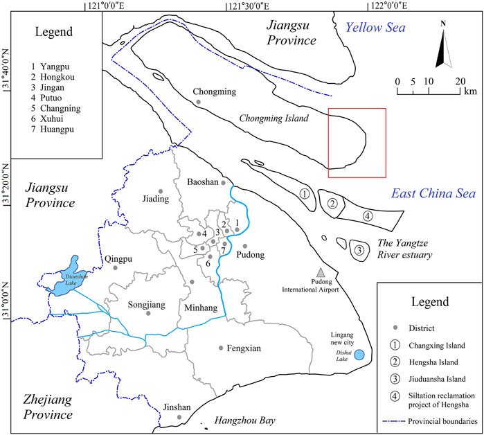
FIGURE 1. The geographical location of eastern Chongming Island, Shanghai City.
Thus, the purpose of this study is to reveal the historical wetland utilization, land-use pattern changes, and the driving factors for the region of eastern Chongming Island, Shanghai. Then, the driving forces will be analyzed to provide explanations of the development stages. This analysis will provide the basis for a discussion of future climate change adaptation to define the role played by the coastal wetland system.
The Study Area
The eastern part of Chongming Island, Shanghai, is in the Yangtze River estuary (Figure 1). It had a total area of 1,267 km2 in the 1980s, with over 90% of its land at an elevation of 3.2–4.2 m (based on Wusong Datum, which is close to the low water on springs) (Zhou, 1989). Sediment discharged from the Yangtze catchment over the last 1,400 years formed this island. By the end of 2019, the total population was around 0.7 million (Chongming District Statistics Bureau, 2020). With a history of artificial cultivation for more than 1,300 years, the formation of Chongming Island benefited from sediment accumulation associated with the evolution of the Yangtze River estuary; modern Chongming Island results from the merging of several sand banks and estuarine shoals (Cao, 1930; Chen, 1957). A combination of intense river flow and tidal currents has shaped a number of sandbanks; and they migrated and merged during the 11-14th centuries (i.e., the Song and Yuan Dynasties). Since the mid-16th century (the middle of Ming Dynasty), the position of Chongming's main island gradually stabilized, with continuous expansions (Chen, 1957; Wei, 1983; Chu, 1987; Zhang, 2005). It is arguably the largest estuarine sedimentary island in the world.
Eastern Chongming Island is a key coastal wetland in Shanghai, with around 682.4 km2 in land area and an average elevation of l–2 m (Wusong Datum), which provides important ecosystem services (Zhou and Xie, 2012). The Dongtan Wetlands (“Dongtan” literally means the eastern tidal flat), with rich natural resources of tidal flats, benthic fauna and vegetation, became a key destination and stopover point for migratory birds in the Asia–Pacific region (Zhou and Xie 2012). Its distinctive geographical location and the habitat for birds earned it a listing as an internationally important wetland in 2002, then in 2005 it gained the designation as a national nature reserve (Figure 1; Figure 2).
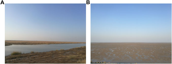
FIGURE 2. The Dongtan wetland landscape of Chongming Island: (A) Artificial wetland inside the new sea dike built in 2015 (see the text for explanation); and (B) intertidal flat outside the new sea dike (natural wetland, including salt marsh and mudflat). Photographs taken by the authors, April 2018.
The Chongming Dongtan Nature Reserve, located on the easternmost tip of Chongming Island, covers an area of 326 km2. The average tidal range is 2.6 m, with a maximum tidal range of 4.6–6.0 m. Its area consists of two parts: 265 km2 of the total area are outside of the sea dike, and the remainder are inside the dike. It is basically a tidal flat, with its internal areas consisting of salt marshes, mudflats, and silt-sand flats (Newton et al., 2020). The marsh plants include local species such as Phragmites australis and Scirpus mariqueter (Yan et al., 2007) and artificially introduced species Spartina alterniflora (Gao et al., 2014). The wetland serves as an important wintering and stopover site for 111 species of migratory waterbirds, together with 94 species of brackish water, seawater, and migratory fish, accounting for over 80% of the total Yangtze estuarine fish species (The Management Office of Shanghai Chongming Dongtan Bird Nature Reserve, 2006).
Materials and Methods
The datasets for this analysis derive from historical documents and published sources, together with field observations and remote sensing images (Google Earth). In China, official records preserved the evolution of coastal zone development and land use for any specific area over the last several hundreds of years. In this study, the records of the study area, from the 18–19th centuries, and the early 20th century were the primary sources. Since the end of the Qing Dynasty, the number of documentary records has increased.
In this region, salt production and subsequent agriculture represented major enterprise in early times. There are relevant documents (see Appendix Table A1), which contain historical information on wetland geomorphology, wetland vegetation distribution, sea dike construction, and traditional production activities associated with the tidal flat environments. We searched these historical documents and related data to identify the tidal flats area, the location of reclamation areas, and the positions of sea dikes and tidal mounds at different times. Then, we derived time-series changes from this data. During the Qing Dynasty, the government surveyed the tidal flats once every three years. Most of the data recounting those surveys were available in the Chronicles of Chongming County (Cao, 1930). It should be noted that tide-mounds represent a special artificial structure at that time. Salt production and agriculture concentrated on the upper parts of the tidal flat, i.e., the environment that was vulnerable to storm surges. In order to reduce storm surge damage, local residents built elevated platforms, consisting of piled tidal flat muds, known as tide-mounds near the production and living locations, so that the people were able to take refuge when a storm event occurred. Unfortunately, few records of the exact time of their building remain in the historical records. Nevertheless, this information is useful, together with the information on sea dikes, to demonstrate the scale and range of human activities. Furthermore, information on the utilization and the management policy for the wetlands, for early times, also existed in the records.
Recent publications and online data provided additional information on the coastal status of the 20th and early 21st centuries. They include the local chronicles of Chongming Island, land-use plans, and comprehensive investigation reports, e.g., Comprehensive Survey Report on Coastal Zones and Tideland Resources of Shanghai (Chen, 1988), Chronicles of Chongming County (Zhou, 1989; Zhang and Zhu, 2013), Chongming Yearbook (published by Chongming County Statistics Bureau during 1989–2019, see Appendix Table A2), the Urban Master Planning of Shanghai (2017–2035), and Statistical Yearbook of Shanghai (Shanghai Statistics Bureau, 2019). These documents yielded information on the development status and social-economic data over the last few decades. Moreover, the photographs from field work and remote sensing images extracted from Google Earth also provided information on wetland landscape changes.
Globally, coastal development and societal responses occurred in three stages, i.e., an early period with fisheries, sea salt production, and agriculture; the era of industrialization and urbanization; and the current ecosystem-oriented use management. However, the scale and timing associated with these stages are highly variable. This pattern is also true for the coastal wetlands of the eastern China region (Bao and Gao, 2020). Here we divided the periods of the coastal development of Chongming Island according to the “three-stage” framework. The shift from one dominant economic period to the next determined the local timing of each stage. Land reclamation was a major activity during the first two periods and, therefore, we combined the data on land reclamation and distribution with information on economic and social life (e.g., economic production, wetland management policy, and population change) to define the dividing points between the different stages.
Results
Three Stages of Regional Development, With Different Land Uses
Until the 18th century, salt production was a major activity on the island (Figure 3). Then, because the shoreline prograded seaward, the accessibility of saline water necessary for the enterprise receded. At the same time, expanding amounts of land became available for agriculture. In response to this landscape change, agriculture came to dominate the study area. This situation basically continued into the mid-20th century, i.e., around 1950. Hence, according to our definition, before 1950 the first stage of coastal development characterized the study area.
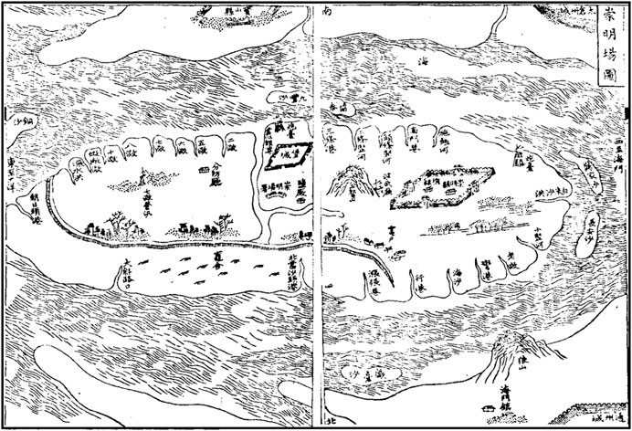
FIGURE 3. Historical map showing the settings of Chongming Saltworks and the landscape of the Island. Note that this map is an overview picture of Chongming Island in the late 18th century, an original picture from Yan (1799), including information of saltworks, river, sea dike, county government setting, without latitude and longitude; north at the bottom and south at the top in this map.
The transition from the second to third stage occurred in 2002 when Dongtan received its formal designation as a nature reserve. Between 1950 and 2002, industrialization was a major goal of Shanghai and this required large land areas. To meet this demand, developers reclaimed about 35 km2 of intertidal land annually, and Chongming contributed a large portion (Zhou, 1989; Zhang and Zhu, 2013). Agriculture and industrial development occupied the reclaimed lands. A number of factories together with harbors and ports transformed sections of the island (Zhang and Zhu, 2013). During this period, although shoreline accretion continued, the total area of natural wetlands declined. An exception was the Dongtan area, where the rate of shoreline advancement exceeded that of reclamation. As a result, a relatively large wetland persisted. The establishment of the Dongtan nature reserve marks the beginning of the third stage. Although some reclamation efforts continued after 2002, the purpose was no longer to obtain the land for agricultural or industrial uses. Rather, it followed an engineering scheme designed to stabilize the environment for migrating birds (Sun, 2020).
Generally, the study area has experienced three stages of the intertidal wetland uses: 1) early development that was dominated by salt and agricultural production; 2) industrial development with rapid reclamation; and 3) conservation of the natural ecosystem, as represented by the nature preserve project. Each of the stages has its unique land use patterns (see below).
Traditional Development and Tidal Flat Conditions Before 1950
The wetlands in the study area maintained a natural landscape until the mid-20th century, with broad salt marshes and mudflats. In this environment, traditional livelihoods concentrated on sea salt production, farming, and fishing (Figure 3) (Zhu and Huang, 1688; Yan, 1799; Lin et al., 1881; Cao, 1930). These activities were vulnerable to river flooding and storm surges, before the mid-16th century due to the highly dynamic environment. For instance, in response to changing conditions, the Chongming County government changed its location five times (Zhang et al., 1604).
Subsequently, the main island gradually stabilized. During the years 1569–1574, local officials modified or built the main water channels in the island, including nine rivers and 33 branch canals to benefit soil desalination and agricultural development (Zhang et al., 1604). At the same time, continuous accretion of tidal flats caused difficulties for sea salt production. The saltworks had to migrate many times, and concentrated in the east of Chongming Island, providing access to seawater after the mid-18th century. During 1698–1826, three major migrations took place, each with a distance of 8–10 km; in 1869, the Qidong coast and Jiangsu Province became the destination of the last such migrations (Bao and Gao, 2020).
According to an inventory of land area of Chongming Island during Qing Dynasty, from 1730 to 1910, the tidal flat area in the island increased by 697 km2 (Cao, 1930), with an annual growth rate of 3.9 km2. After the mid-18th century, cotton plantations gradually replaced salt production (Bao and Gao, 2020). Since the early Qing Dynasty (i.e., the beginning of the 18th century), cotton fields expanded to occupy half of the total area of Chongming Island, as farmers continuously transformed the tidal flat wetlands into cotton fields (Zhang, 1727). In the mid-18th to the mid-19th centuries, the cotton planting area accounted for 60–70% of the total land area (Bao and Gao, 2020). In addition to salt-making and cotton farming, some fishermen collected shellfish or engaged in small-scale fishing over the shoals (Lin et al., 1881; Cao, 1930).
Sea dike construction and migration to the east in this region was an important part of the traditional development. There were two major old sea dikes: the first was built in 1593, and the second in 1762, some 2–3 km from the shoreline and 20–30 km seaward to the first one. Historical records identify it as the Zhaogong Dike (Bao and Gao, 2020). Further, residents built special life-saving facilities known as tide-mounds (Earth mounds, with a relative height of 2–4 m above ground) on the tidal flat. A total of 42 were built in 1732; they were maintained and rebuilt in 1751, along with nine more built on the newly formed high flat (Lin, et al., 1881). Generally, the tide-mounds occupied locations near the saltworkers settlements, providing emergency shelter when a storm surge came. Each of them could accommodate 100–300 people (Bao et al., 2020). Although the documents do not reveal the specific locations of the nine tide-mounds newly built in 1751, they likely stood near the 1762 sea dike (Figure 4).
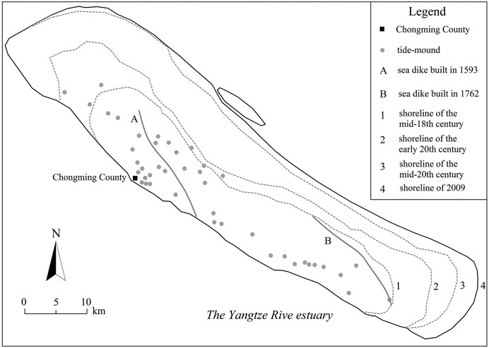
FIGURE 4. Historical shoreline, sea dike and tide-mound changes of Chongming Island. The distribution changes of tide-mounds and sea dikes were from the Chronicles of Chongming County (Zhu et al., 1688; Zhang et al., 1727; Zhao et al., 1760; Lin et al., 1881; Cao 1930, see Appendix). Data on shoreline changes were from the Chronicles of Chongming County (Cao 1930; Yun, 2010).
In Chongming Island, according to the tide-mound distribution and shoreline changes, the outer boundary of traditional development activities mainly existing within the shoreline of the mid-18th century, terminating in the eastern part of the island at the 1762 sea dike (Figure 4). Beyond this boundary, there was no reclamation until the mid-20th century. The seaward expansion of sea salt production and agricultural activities was slow: outside this sea dike, there were vast salt marshes and mudflats, scattered with some saltworks (Figure 3).
Tidal flat reclamation needed engineering technologies, which had not yet been introduced from the western countries. Thus, it was too costly to transform tidal flats into agricultural land. Before the 20th century, traditional means maintained coastal wetland development, i.e., the extent and scale of human modification was limited.
Industrialization and Rapid Modification to Natural Wetlands During 1950–2001
After the mid-20th century, especially following 1979, Shanghai’s economy expanded rapidly, creating a large demand for land resources. To meet this need, officials reclaimed 1953 and 2005, 1,014 km2 of land area from tidal flats (Yun, 2010). Chongming Island became a major reclamation region, accounting for 60% of Shanghai’s reclaimed territory (Figure 5). At this stage, the most prominent feature of land-use was the rapid encroachment on natural tidal flats. Modern engineering technology enabled construction of high-standard sea dikes to generate additional land resources for the expansion of agricultural and industrial communities.
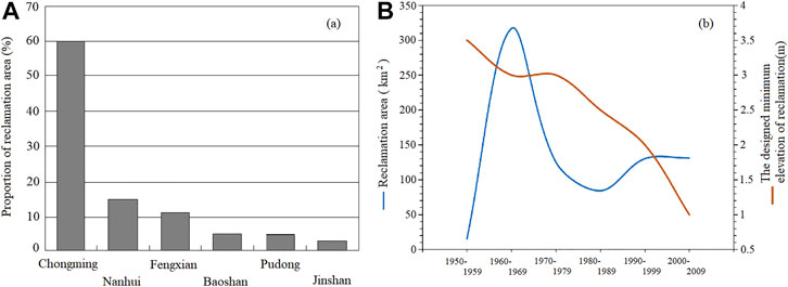
FIGURE 5. Reclamation of Chongming Island after the mid-20th century. (A) Comparison of reclamation scale of the suburban counties of Shanghai during 1953–2004; (B) Historical changes of coastal wetland reclamation area changes and the designed minimum elevation of reclamation in Chongming Island. Data on reclamation were based on the Chronicles of Chongming County (Zhou, 1989), the Chronicles of Chongming County (Zhang and Zhu, 2013), and the Chongming Yearbook published by Chongming County Statistics Bureau during 1989–2010 (see Appendix Table A2). Nanhui District was officially incorporated into Pudong New District in 2009.
In Chongming, there have been several large-scale reclamation schemes since the mid-20th century (Figure 5). In 1950, the island had a total land area of around 600 km2, but 60 years later it reached 1,267 km2. This involved reclaiming more than 650 km2. Likewise, land utilization changed. Before the 1970s, agriculture was the main activity, but after the 1970s, the main purpose for obtaining land was industrial development. The rapid reclamation of wetlands provided land space for the expansion of coastal farms, the construction of ports, and other industrial facilities. Transportation infrastructure directly promoted additional industrialization of the industrial structure. At the end of the 20th century, the proportion land dedicated to secondary industry in Chongming County reached 37% (Chongming Yearbook in 2000, see Appendix Table A2).
The Dongtan wetlands were one of the key reclamation areas (Figures 6, 7). Chongming Dongtan experienced peak periods of reclamation from 1960 to 1970, and from 1990 to 2001; which included prominent large-scale reclamation events in 1992, 1998, and 2001. Additionally, there were nine large-scale engineering schemes for sea dike building (Figure 6). However, there were some changes in the functioning of the sea dikes. In the 1960s and 1970s, the sea dikes provided barriers that enabled reclamation. In the 1980s and 1990s, engineers designed them to accelerate sedimentation on the tidal flat. After the Dongtan wetlands became an internationally important wetland according to the Ramsar Convention, its main purpose was to prevent coastal erosion and enhance the stability of the wetland ecosystem.
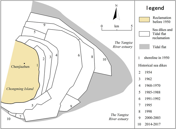
FIGURE 6. Historical changes of sea dike and wetland reclamation in eastern Chongming Island. Data on shoreline and sea dike changes were based on Yun (2010), Yang et al. (2005), the Chronicles of Chongming County (Zhang and Zhu, 2013), the Chronicles of Chongming County (Zhou, 1989), and the Chongming Yearbook (Chongming District Statistics Bureau, 2020).
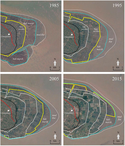
FIGURE 7. The satellite images of sea dikes and tidal flats reclamation in eastern Chongming Island. The red line represents the location of the sea-dike in 1762; the black line represents the shoreline in 1950; the white line represents old sea dikes; the yellow line represents new sea dikes in different periods; the broken blue line represents the boundary of salt marsh, and the broken white line represents the boundary of mudflat. Data on remote sensing image in four typical periods were excerpted from Google Earth; data on historical sea dikes and shoreline were excerpted from Yun (2010), Yang (2005), the Chronicles of Chongming County (Zhang and Zhu, 2013) and the Chronicles of Chongming County (Zhou, 1989).
At this stage, nevertheless, the rate of reclamation exceeded the rate of accretion; as a result, salt marshes were progressively shrinking, in response to repeated sea dike construction projects (Figure 7). In Dongtan, the natural wetland area decreased from 197 km2 in 1987 to 47.7 km2 in 2002, a reduction of 75.8% (Gao and Zhao, 2006). Meanwhile, the designed minimum elevation of reclamation continuously fell, from above 3 m in 1950 to lower than 1 m (Wusong Datum) in 2009 (Figure 5).
For the entire island, the wetland area declined from 1,686 km2 in 1980 to 1,350 km2 in 2018 (i.e., a decrease of 20%). The reduction occurred mainly between the sea dike of 2,000 and the −5 m bathymetry isoline. Because of the inherent sedimentation laws associated with a tidal flat environment (Gao, 2014), the building of sea dikes can modify the cross-shore profile, i.e., increasing the temporal accretion rates the upper parts of the flat, which was observed a long time ago by Chen (1957).
Transformation Period for Land Use Pattern Since 2002
In the Urban Master Plan of Shanghai (1999-2020), issued by the Shanghai government in 1999 lists, Chongming Island as an important strategic reserve space for the city, but the important turning point was 2002 when Dongtan received designation as an internationally important wetland. The local government started to control the reclamation scale, but some engineering schemes continued with a new purpose to enhance the ecosystem services of the wetlands (Chongming District Statistics Bureau, 2020).
The government issued relevant policies, providing financial support to wetland protection, though it took a long period of time to make the necessary decisions. As early as 1992, officials discussed the feasibility of creating the Dongtan nature reserve. The Shanghai government officially approved the founding of the “Shanghai Chongming Dongtan Bird Nature Reserve” in 1998. The Ramsar designation followed in 2002 and involved an area of 84 km2 in 2002. Eventually, the State Council approved it to be a national nature reserve in 2005 (Ma and Ma, 2006; Xu, 2006).
Some relevant enterprises also played a role in the protection of Dongtan wetland resources. In May 2003, Shanghai Dongtan Wetland International Co., LTD. was incorporated, with a commitment to maintain the wetland services for the area between the sea dikes of 1992 and 1998 and to support migratory birds. The services include providing natural protection, scientific research and education, and ecological tourism and leisure resort.
The work plan of the Dongtan nature reserve shows that it will share 243.4 km2, with the area of Chongming Dongtan Wetland of International Importance (which covers a total of 326 km2) (Figure 8). Meanwhile, these designation restricted development within the area between the sea dikes built in 1968 and 1998. The area outside the sea dikes built in 1998–2001 became an ecological experimentation zone and a core region for the wetlands with salt marshes and mudflats (Figure 8). The most recent dike was completed between 2014 and 2017 to stabilize a part of the nature reserve as space for migrating birds. Thus, Dongtan has become a key experimental area for promoting coastal wetland ecosystem protection. By 2019, the wetland area for ecosystem protection according to local regulations reached 67.5% of the total of Chongming Island (Chongming District Statistics Bureau, 2020). In the Dongtan area 90% is dedicated to ecosystem protection. Furthermore, “green” engineering technology is reforming the existing sea dikes (Sha et al., 2008).
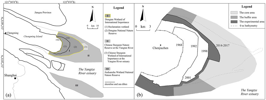
FIGURE 8. Dongtan wetland conservation planning: (A) spatial distribution of the conservation projects; and (B) functional zone planning map of Dongtan National Nature Reserve. Compiled by the Kunming Survey and Design Institute of State Forestry Administration (2010).
Overall, during the period from 2010 to 2020, the ecosystem-oriented construction improved the forest coverage rate, the quality of soil and air, the conditions of rural living and transport infrastructure, and promoted the development of the new industries, including flower gardens, the Dongtan Wetland Park, sports leisure and health activities, and other coastal tourism functions (Sun, 2020). These changes have brought more direct benefits to local peoples in term of employment and well-being. Now both the government and the local stakeholders believe that the maintenance of its natural environment and ecosystem services is vital to protecting the green space of Shanghai.
Discussion: The Driving Factors
Sediment Supply and Sea Level Rise
Sediment discharge from the Yangtze river is the controlling factor for the wetland accretion growth rate (He et al., 2010). However, the upstream dams and other human activities in the Yangtze catchment have caused a decrease in sediment supply which has allowed tidal flat erosion (Yang et al., 2005; Yang et al., 2011; Luo et al., 2015; Yao et al., 2017). The average sediment discharge during 1951–2000 was 425 × 106 t/yr (Wei et al., 2015), but fell sharply after 2000 to an average of 177 × 106 t/yr from 2001 to 2010 and 114 × 106 t/yr from 2011 to 2019 (Ministry of Water Resources, 2003–2019) (Figure 9A).
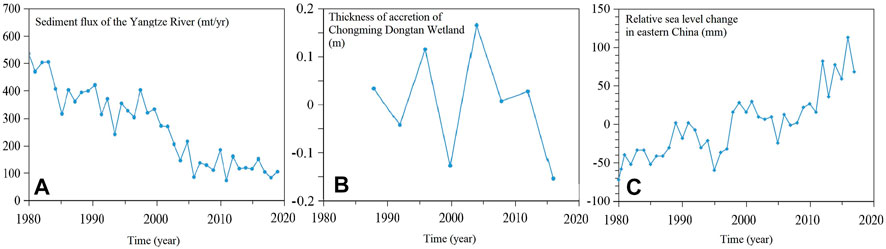
FIGURE 9. The time-series of sea level, sediment flux and tidal flat accretion/erosion during 1980–2020: (A) sediment discharge from the Yangtze river in 1980–2002 (after Wei, 2015), and data in 2003–2019 were collected from Bulletin of China River Sediment (Ministry of Water Resources, 2003–2019, see Appendix Table A2); (B) sedimentation rates at the Dongtan wetlands (after He, 2020) and (C) local sea level curve (from Wang, 2018).
From 1762 to 1955, the rate of shoreline progradation, averaged 7 m/yr (Yang et al., 2001), but in the past 60 years it was around 200 m/yr, with an average annual growth rate of tidal flat area of 2.8 km2/yr (Yao et al., 2017). Reclamation that caused readjustment of the cross-shore profile produced this change. Reclamation was most intensive during the 1990s, causing a shoreline advancement of 350 m/yr (Yao et al., 2017). However, as a result of the decline in sediment supply from the Yangtze River since 2000, the shoreline progradation rate declined to around 70 m/yr. On the upper parts of the tidal flat, the rate of accretion trended downward at Dongtan (Figure 9B). With reduced sediment supply from the river, the shallow water areas adjacent to the eastern island have experienced slight erosion during the last 40 years (Figure 10). During the years 1980–2004, the −5 m bathymetry isoline retreated toward the land, but it was generally stable from 2004 to 2018 (Yang et al., 2019). In the near future, sediment supply reduction will likely continue, which implies a reduced rate or termination of wetland growth (Yang et al., 2005; Li et al., 2006).
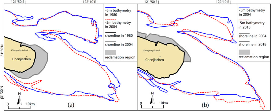
FIGURE 10. The shallow water areas (within −5m bathymetry, Wusong Datum) during 1980–2018 (after Yang et al., 2019). Note that the shorelines of 2004–2018 were artificial (by reclamation).
Further, the region is now influenced by sea-level rise. The rising water level and intensified storm erosion will impede wetland growth (Tian et al., 2010). According to the Ministry of Natural Resources (2020), from 1980 to 2019, the rate of sea-level rise along China's coastlines reached 3.4 mm/yr, which is higher than the global average (Figure 9C). Experts expect the sea level to rise another 51–179 mm in the next 30 years. Thus, the Dongtan wetlands will be at a high risk of being flooded and eroded (Yin et al., 2020). A representative scenario showed that flooding will threaten 64.1 × 10³ km2 in 2050 and 67.8 × 10³ km2 in 2080 of the Yangtze River delta, with an assumption of 3 mm/yr rise (Zuo et al., 2013). Likewise, inundation will impact around 40% of the land area of the Dongtan reserve by 2,100, based on a rate of rise of 0.88 m (Tian et al., 2010).
Hence, sediment supply and sea-level change are two of the key driving forces for wetland growth in the eastern Chongming area. In the past, the wetland growth may be divided into two periods: rapid expansion from the 1950s to the 1980s due to continued Yangtze river sediment discharge, and termination or erosion since the 1990s due to a combination of sediment supply reduction and sea level rise. For the future, the transformation from accretion to erosion and the likely intensification of erosion will cause problems to the Dongtan wetlands. Solutions must be sought to sustain or protect the wetlands, and should be incorporated in future land-use planning.
Population, Economic Growth, and Wetland Management Policy
As the largest city in China, Shanghai has a total land area of 6,340 km2, but its rapid population growth creates challenges in terms of the human-land relationships (Wang and Yu, 2012). The GDP of Shanghai in 1980 was 31.2 × 10⁹ RMB (i.e., 4.8 × 10⁹ USD); it reached 3,268 × 109 RMB (i.e., 506.5 × 10⁹ USD) in 2018 (Shanghai Statistics Bureau, 2019). Meanwhile, the total population of Shanghai increased from 11.04 × 10⁶ people in 1978 to 24.24 × 10⁶ by the end of 2018; the population density increased rapidly from 1,785 people in 1978 to 3,823 people per km2 in 2018.
In comparison, the current population of Chongming is the lowest in Shanghai (Figure 11). Actually, after reaching a peak in the 1970s, the population has been declining for the last four decades, with a present population of 0.69 × 10⁶ (Figure 11). The population density is also lowest in Shanghai, too, presently being 580 people per km2 (Figure 11).
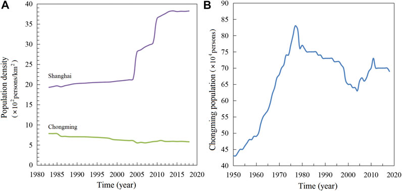
FIGURE 11. Population changes of Shanghai and Chongming District: (A) population density changes during 1980–2018 (after Shanghai Statistics Bureau, 2019); and (B) population changes of Chongming District since 1950 (Zhou, 1989; Shanghai Statistics Bureau, 2019).
The land resources are so important for the continued development of Shanghai, and the existing coastal wetlands, with an area of 3.87 × 10³ km2 (Cai et al., 2014), are an important strategic space. However, cultivation of some of these wetlands depends on a government decision, which should be made on the basis of sound wetland management policies.
Presently, the wetland ecosystem services and the adaptation to future environment/sea-level change have become a priority in decision making. As far as the Chongming government is concerned, a Master Plan of Shanghai Chongming District Land Use (2017–2035), issued in 2018 (Chongming District Government, 2018), strengthens the policy of protecting the wetland ecosystems. The plan sets a limit of the population (i.e., a maximum of 0.7 × 10⁶ people), prohibits further reclamation schemes, and reiterates that financial inputs will be guaranteed to maintaining the nature reserve. A program, known as “Eco-Chongming” seeks to manage the island in accordance with the plan (Sun, 2020). Its goal is to enhance the ecosystem services of the entire island, to improve the quality of urbanization, and to explore a new, ecosystem-oriented land-use pattern which will be resilient to environment/climate changes.
Hence, in addition to sediment supply and sea level rise, the population dynamics, economic growth, and wetland management policy are also the driving forces for the future of the Dongtan wetlands.
Options of Adaptation to Future Climate Changes
The third group of driving forces consists of the options for an appropriate adaptation to future climate change. On the one hand, before the end of the 20th century, the abundant sediment supply was beneficial to the wetland growth, which supported the reclamation activity. On the other hand, the rising sea level and the sharp decrease of the river sediment supply will force the termination of reclamation, since tidal flats are no longer growing due to natural processes. Generally, at the long-term century temporal scale, sea-level change has an important impact, whilst at the recent ten-year scale, human reclamation had the greatest impact on wetlands, by influencing the river discharge and modifying the morphology of the intertidal zone. Until the end of the 20th century, there was a balance between the utilization of intertidal lands and wetland growth, but managing wetlands now depends upon the emerging patterns of climate change.
Sea level is not only rising, but the rise is also accelerating. At the same time, the intensity of storm surges will increase (Ministry of Natural Resources, 2020). One option to adapt to the marine change is to follow a managed realignment policy (e.g., Turner et al., 2007). This course, once made, would lead to the abandonment of some important coastal resources including infrastructures like harbors and sea dikes. Society would retreat to places with higher elevations. The coastal ecosystems, e.g., wetlands, will migrate landward: spaces will be arranged to accommodate these systems. Specifically, for our study area, the local government and stakeholders will have to give up their efforts to protect the Dongtan wetlands.
Indeed, the new set marine changes will have a huge impact on the safety of the coastal megacities, to say nothing of the associated wetlands. Beyond China, similar concerns exist. In Asia, the large-scaled, densely populated coastal cities such as Ho Chi Minh, Kolkata, Dhaka, and Manila face serious flood-related problems (The World Bank, 2010; Blankespoor et al., 2014).
In these regions, it is extremely difficult to adopt the managed realignment policy. China will have the highest population in its coastal lowland by 2060 (Hauer et al., 2020). If the people of Shanghai, for instance, will have to be resettled in inland regions, then the required space and material resources do not exist at the present time. As a result, the coastal communities will continue to run the coastal cities, at least for some prolonged period. In Shanghai, the “Urban Master Planning 2017–2035” (Shanghai municipality government, 2018) expresses the desire to do so. It has set a number of goals for future development, including the expansion of green space, the scale and spatial range of urban land uses, and the environmental protection criteria. In this conception, the coastal wetlands must be protected; the remaining question would be how to realize this ambitious goal (Schuerch, 2018).
What adaptation strategies are suitable for the local characteristics of Shanghai? Obviously the fate of the city will be linked with the fate of the coastal wetlands. Scientific research about the flooding risks and mitigation measures, prevention of coastal erosion, the maintenance of coastal facilities, as well as appropriate management and adaptation policies are essential. In addition, the experiences gained from historical development, together with the technology, e.g., the transformation of the land-uses to fit into the new tidal flat dynamic situations. Sustainability depends upon the solutions from this research and these experiences. Likewise, the sustainability of the coastal wetlands will depend on the suitability of the management policies (Woodruff, 2018).
For the Dongtan wetlands, the transformation from reclamation-oriented wetland utilization toward ecosystem protection represents the first step toward that “continuation” option. We suggest that the next steps would be to maintain the ecological niche of the wetlands, so that they can survive in even the severest environmental settings, to create new approaches to coastal engineering with contributions made by the ecosystem (i.e., “green”) engineering schemes, and to foster better ecosystem services. The Dongtan wetlands have the potential to provide a pilot example for future adaptation. With the time window gained from this pilot project, the city would be in a good position to decide which option to adopt, to retreat or to resist (such as adherence/persistence adaptation).
Conclusion
(1) Eastern Chongming Island is a key area reflecting multiple long-term wetland utilization patterns in Shanghai. The related coastal development passed through three stages: traditional land use before 1950 as characterized by salt production, fishing and agriculture; industrialization with rapid land reclamation during 1950–2001; and the land-use pattern orientated toward wetland ecosystem protection after 2002.
(2) The timing and the scale of the different stages have been controlled by natural and human induced processes, including riverine sediment discharges, sea level changes, population and economic growth, and wetland management policy. During the first stage, the continuous sediment supply and wetland growth sustained regional development. However, during the second stage, the balance between the reclamation and wetland growth was broken due to the reduction of the sediment supply and sea-level rise, consequently development became unsustainable. The third stage is underway as and reflects a response to the demand of ecosystem services and the climate changes.
(3) The fate of the wetlands, like that of the city itself, depends on adaptation options for coping with future climate changes. For densely populated megacities, such as Shanghai, retreat may not be the best option. Rather, it will be suitable for the coastal communities to remain in place if planners, scientists, and policy makers can devise solutions, based on historical experiences, to the problems of flood risk, coastal erosion, and the maintenance of coastal facilities.
(4) Regarding the second option, i.e., adherence or persistence adaptation, as adopted by the Shanghai government in the Dongtan wetlands, it has a potential to provide a pilot example for future adaptation. For these wetlands, the transformation from the reclamation-oriented utilization to wetland ecosystem protection was the first step toward the adherence adaptation option. We suggest that the next steps should seek to maintain the wetlands’ ecological niche, to create new approaches to coastal engineering with contributions from the ecosystem, and to provide better ecosystem services.
Data Availability Statement
The original contributions presented in the study are included in the article/Supplementary Material, further inquiries can be directed to the corresponding author.
Author Contributions
BJ and GS conceived the research together. BJ collected materials and wrote the paper. BJ and GS revised the paper together.
Funding
This work was supported by the National Social Science Fund of China, through the project “Climate change and traditional adaptation on Jiangsu-Shanghai coasts” (Grant Number:18BZS156), and the Scientific Research and Innovation Program of Shanghai Municipal Education Commission, through the major project of humanities and social science, entitled “Study on the differentiation process and development mechanism of climate change adaptation pattern in historical periods in Shanghai City” (Grant Number: 2021–01–07–00–07-E00123).
Conflict of Interest
The authors declare that the research was conducted in the absence of any commercial or financial relationships that could be construed as a potential conflict of interest.
Appendix
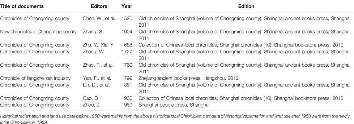
TABLE A1. The relative historical documents in wetland development data of the Chongming Island.
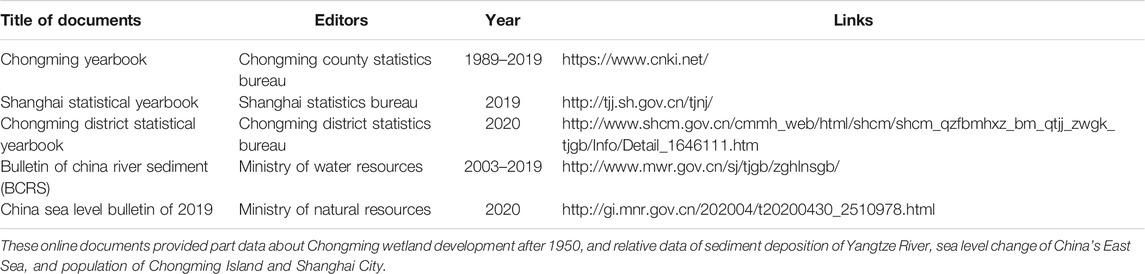
TABLE A2. The main online data set related to Chongming Island, river sediment of Yangtze River and sea level of China.
References
Bao, J., Gao, S., and Ge, J. (2020). Coastal Engineering Evolution in Low-Lying Areas and Adaptation Practice since the Eleventh century, Jiangsu Province, China. Climatic Change 162, 799–817. doi:10.1007/s10584-020-02738-x
Bao, J., Gao, S., and Ge, J. (2019a). Dynamic Land Use and its Policy in Response to Environmental and Social-Economic Changes in China: A Case Study of the Jiangsu Coast (1750-2015). Land Use Policy 82, 169–180. doi:10.1016/j.landusepol.2018.12.008
Bao, J., Gao, S., and Ge, J. (2019b). Salt and Wetland: Traditional Development Landscape, Land Use Changes and Environmental Adaptation on the Central Jiangsu Coast, China, 1450-1900. Wetlands 39, 1089–1102. doi:10.1007/s13157-019-01144-z
Bao, J., and Gao, S. (2020). The Development of Chongming Island and Aquatic Environment of the Yangtze River Estuary in the Ming and Qing Dynasties. Hist. Rev. 2, 81–92.(in Chinese)
Binh, D. V., Kantoush, S. A., Saber, M., Mai, N. P., Maskey, S., Phong, D. T., et al. (2020). Long-term Alterations of Flow Regimes of the Mekong River and Adaptation Strategies for the Vietnamese Mekong Delta. J. Hydrol. Reg. Stud. 32, 100742. doi:10.1016/j.ejrh.2020.100742
Blankespoor, B., Dasgupta, S., and Laplante, B. (2014). Sea-level Rise and Coastal Wetlands. Ambio 43, 996–1005. doi:10.1007/s13280-014-0500-4
Cai, Y., Zhou, Y., and Tian, B. (2014). Shanghai Wetlands. Shanghai: Shanghai Science and Technology Press.(in Chinese)
Chen, J. (1988). Comprehensive Survey Report on Coastal Zones and Tideland Resources of Shanghai. Shanghai: Shanghai Science and Technology Press.(in Chinese)
Chen, J. (1957). The Topographic Development of the Estuary of Yangtze River Delta. Acta Geographica Sinica 3, 241–253.(in Chinese)
Chen, W., Wang, D., Huang, Y., Chen, L., Zhang, L., Wei, X., et al. (2017). Monitoring and Analysis of Coastal Reclamation from 1995-2015 in Tianjin Binhai New Area, China. Sci. Rep. 7, 3850. doi:10.1038/s41598-017-04155-0
Chongming District Government (2018). Master Plan of Shanghai Chongming District and Master Plan of Land Use. http://www.shcm.gov.cn/cmmh_web/html/shcm/SHCM_ZJCM_PLANN/List/mobile/index.html (Accessed October 20, 2020).(in Chinese)
Chongming District Statistics Bureau (2020). Chongming District Statistical Yearbook. http://www.shcm.gov.cn/cmmh_web/html/shcm/shcm_qzfbmhxz_bm_qtjj_zwgk_tjgb/Info/Detail_1646111.htm (Accessed October 20, 2020).(in Chinese)
Colten, C. E. (2019). Adaptive Transitions: The Long‐Term Perspective on Humans in Changing Coastal Settings. Geographical Rev. 109 (3), 416–435. doi:10.1111/gere.12345
Davidson, N. C. (2014). How Much Wetland Has the World Lost? Long-Term and Recent Trends in Global Wetland Area. Mar. Freshw. Res. 65, 934. doi:10.1071/MF14173
Du, S., Scussolini, P., Ward, P. J., Zhang, M., Wen, J., Wang, L., et al. (2020). Hard or Soft Flood Adaptation? Advantages of a Hybrid Strategy for Shanghai. Glob. Environ. Change 61, 102037. doi:10.1016/j.gloenvcha.2020.102037
Gao, S., Du, Y., Xie, W., Gao, W., Wang, D., and Wu, X. (2014). Environment-ecosystem Dynamic Processes of Spartina Alterniflora Salt-Marshes along the Eastern China Coastlines. Sci. China Earth Sci. 57 (11), 2567–2586. doi:10.1007/s11430-014-4954-9
Gao, Y., and Zhao, B. (2006). The Influence of Human Reclamation Activities on the Development of Chongming Dongtan Wetland in Shanghai. Chin. Agric. Sci. Bull. 8, 475–479.(in Chinese)
Goodwin, P., Mehta, A. J., and Zedler, J. B. (2001). Coastal Wetland Restoration: an Introduction. J. Coastal Res. 27, 1–6.
Guan, D., Liu, C., Zuo, P., Ye, S., L, J., and Li, R. (2012). China’s Coastal Wetlands. Beijing: Ocean Press.(in Chinese)
Hadley, D. (2009). Land Use and the Coastal Zone. Land Use Policy 26 (S1), S198–S203. doi:10.1016/j.landusepol.2009.09.014
Hallegatte, S., Green, C., Nicholls, R. J., and Corfee-Morlot, J. (2013). Future Flood Losses in Major Coastal Cities. Nat. Clim Change 3, 802–806. doi:10.1038/NCLIMATE1979
Hanson, S., Nicholls, R., Ranger, N., Hallegatte, S., Corfee-Morlot, J., Herweijer, C., et al. (2011). A Global Ranking of Port Cities with High Exposure to Climate Extremes. Climatic Change 104, 89–111. doi:10.1007/s10584-010-9977-4
Hauer, M. E., Fussell, E., Mueller, V., Burkett, M., Call, M., Abel, K., et al. (2020). Sea-level Rise and Human Migration. Nat. Rev. Earth Environ. 1, 28–39. doi:10.1038/s43017-019-0002-9
He, X., Dai, X., and Gu, C. (2010). Geomorphic Evolution of Eastern Chongming Island during the Last 40 Years and its Future Trend,based on the Sea Charts Comparison. Mar. Geology. Quat. Geology. 30 (04), 105–114. doi:10.3724/sp.j.1140.2010.04105(in Chinese)
He, Y. (2020). Study on the Coastal Change Process Around Chongming Island. Shanghai: Master Dissertation, East China Normal University.(in Chinese)
Huu Nguyen, H., Dargusch, P., Moss, P., and Tran, D. B. (2016). A Review of the Drivers of 200 Years of Wetland Degradation in the Mekong Delta of Vietnam. Reg. Environ. Change 16 (8), 2303–2315. doi:10.1007/s10113-016-0941-3
IPCC (2014). Climate Change 2014: Impacts, Adaptation, and Vulnerability. Part a: Global and Sectoral Aspects. Cambridge: Cambridge University Press.
Jiang, T.-t., Pan, J.-f., Pu, X.-M., Wang, B., and Pan, J.-J. (2015). Current Status of Coastal Wetlands in China: Degradation, Restoration, and Future Management. Estuarine, coastal Shelf Sci. 164, 265–275. doi:10.1016/j.ecss.2015.07.046
Kirwan, M. L., and Megonigal, J. P. (2013). Tidal Wetland Stability in the Face of Human Impacts and Sea-Level Rise. Nature 504, 53–60. doi:10.1038/nature12856
Kunming Survey and Design Institute of State Forestry Administration (2020). Functional Zone and Planning Map of Chongming Dongtan National Nature Reserve.(in Chinese). http://www.dongtan.cn/sites/dongtan/baohuqu.aspx?ctgId=b7c758d2-8f23-4bda-a8c0-c0bd4c3765f0 (Accessed October 20, 2020).
Larson, C. (2015). China’s Vanishing Coastal Wetlands Are Nearing Critical Red Line. Science 350 (6260), 489. doi:10.1126/science.aad4759
Li, M., Yang, S., Li, P., Liu, Z., Dai, S., Hao, A., et al. (2006). The Decrease of Sediment along the Yangtze River and the Crisis of Tidal Flat Resources. Acta Geographica Sinica 3, 282–288.(in Chinese)
Lin, D. (1881). Chronicles of Chongming County. Shanghai: Reprinted by Shanghai Ancient Books Press.(in Chinese)
Lin, Q., and Yu, S. (2018). Losses of Natural Coastal Wetlands by Land Conversion and Ecological Degradation in the Urbanizing Chinese Coast. Sci. Rep. 8, 15046. doi:10.1038/s41598-018-33406-x
Lotze, H. K., Lenihan, H. S., Bourque, B. J., Bradbury, R. H., Cooke, R. G., et al. (2006). Depletion, Degradation, and Recovery Potential of Estuaries and Coastal Seas. Science 312, 1806–1809. doi:10.1126/science.1128035
Luo, X. X., Yang, S. L., Wang, R. S., Zhang, C. Y., and Li, P. (2017). New Evidence of Yangtze delta Recession after Closing of the Three Gorges Dam. Sci. Rep. 7, 41735. doi:10.1038/srep41735
Ma, T., Li, X., Bai, J., and Cui, B. (2019). Impacts of Coastal Reclamation on Natural Wetlands in Large River Deltas in China. Chin. Geogr. Sci. 29 (4), 640–651. doi:10.1007/s11769-019-1049-8
Ma, X., Du, J., Liang, Y., and Zhang, D. (2018). Changes of Coastal Wetlands in the Yangtze River delta for 6 Periods since 1960s and Their Driving Factors. Wetland Sci. 16 (3), 304–312. doi:10.13248/j.cnki.wetlandsci.2018.03.004
Ma, Y., and Ma, Z. (2006). Chongming Dongtan Wetland of International Importance. Beijing: China Forestry Press. doi:10.1007/978-3-211-69325-4(in Chinese)
Ministry of Natural Resources (2020). China Sea Level Bulletin of 2019. http://gi.mnr.gov.cn/202004/t20200430_2510978.html (Accessed January 8, 2021).(in Chinese)
Ministry of Water Resources (2003-2019). Bulletin of China River Sediment (BCRS), 2003-2019. (Accessed January 8, 2021).(in Chinese)
Newton, A., Icely, J., Cristina, S., Perillo, G. M. E., Turner, R. E., Ashan, D., et al. (2020). Anthropogenic, Direct Pressures on Coastal Wetlands. Front. Ecol. Evol. 8, 144. doi:10.3389/fevo.2020.00144
Nguyen, H. H., Dargusch, P., Moss, P., and Aziz, A. A. (2017). Land-use Change and Socio-Ecological Drivers of Wetland Conversion in Ha Tien Plain, Mekong Delta, Vietnam. Land Use Policy 64, 101–113. doi:10.1016/j.landusepol.2017.02.019
Nicholls, R. J. (1995). Coastal Megacities and Climate Change. GeoJournal 37, 369–379. doi:10.1007/BF00814018
Ramsar Convention on Wetlands (2018). Global Wetland Outlook: State of the World’s Wetlands and Their Services to People. Switzerland: Gland. Ramsar Convention Secretariat.
Schuerch, M., Spencer, T., Temmerman, S., Kirwan, M. L., Wolff, C., Lincke, D., et al. (2018). Future Response of Global Coastal Wetlands to Sea-Level Rise. Nature 561, 231–234. doi:10.1038/s41586-018-0476-5
Sha, W., Yu, F., and Zhang, Z. (2008). Construction Countermeasures of Ecological Seawall in Chongming Island. Shanghai Construction Technology 2, 30–32+39.(in Chinese)
Shanghai municipality government (2018). Shanghai Urban Master Planning of Shanghai (2017-2035). (In Chinese). http://www.shanghai.gov.cn/newshanghai/xxgkfj/2035001.pdf (Accessed October 20, 2020).
Shanghai municipality government. (1999). Urban Master Planning of Shanghai(1999-2020). (In Chinese).
Shanghai Statistics Bureau (2019). Shanghai Statistical Yearbook. http://tjj.sh.gov.cn/tjnj/(Accessed October 20, 2020).(In Chinese)
Sterzel, T., Lüdeke, M. K. B., Walther, C., Kok, M. T., Sietz, D., and Lucas, P. L. (2020). Typology of Coastal Urban Vulnerability under Rapid Urbanization. PLOS ONE 15 (1), e0220936. doi:10.1371/journal.pone.0220936
Sun, B. (2020). Green Book of Chongming World-Class Eco-Island. Beijing: Science Press. doi:10.1061/9780784483237.070(in Chinese)
Sun, Z., Sun, W., Tong, C., Zeng, C., Yu, X., and Mou, X. (2015). China's Coastal Wetlands: Conservation History, Implementation Efforts, Existing Issues and Strategies for Future Improvement. Environ. Int. 79, 25–41. doi:10.1016/j.envint.2015.02.017
Temmerman, S., and Kirwan, M. L. (2015). Building Land with a Rising Sea. Science 349 (6248), 588–589. doi:10.1126/science.aac8312
Temmerman, S., Meire, P., Bouma, T. J., Herman, P. M. J., Ysebaert, T., and De Vriend, H. J. (2013). Ecosystem-based Coastal Defence in the Face of Global Change. Nature 504, 79–83. doi:10.1038/nature12859
The Management Office of Shanghai Chongming Dongtan Bird Nature Reserve (2006). Chongming Dongtan International Important Wetland. Beijing: China Forestry Press.(in Chinese)
The State Council (2018). Notice on Strengthening the Protection and Strict Control of Coastal Wetlands Reclamation. http://www.gov.cn/zhengce/content/2018-07/25/content_5309058.htm (Accessed October 20, 2020).(in Chinese)
The World Bank (2010). Climate Risks and Adaptation in Asian Coastal Megacities. https://onlinelibrary.wiley.com/doi/10.1111/j.1728-4457.2012.00543.x.
Tian, B., Zhang, L., Wang, X., Zhou, Y., and Zhang, W. (2010). Forecasting the Effects of Sea-Level Rise at Chongming Dongtan Nature Reserve in the Yangtze Delta, Shanghai, China. Ecol. Eng. 36 (10), 1383–1388. doi:10.1016/j.ecoleng.2010.06.016
Turner, R. K., Burgess, D., Hadley, D., Coombes, E., and Jackson, N. (2007). A Cost-Benefit Appraisal of Coastal Managed Realignment Policy. Glob. Environ. Change 17 (3), 397–407. doi:10.1016/j.gloenvcha.2007.05.006
Wang, H., Liu, Q., Li, H., Li, W., and Jin, B. (2018). Advances in Sea Level Change Research. Mar. Inf. 33 (3), 19–25+54. doi:10.19661/j.cnki.mi.2018.03.005(in Chinese)
Wang, Y., and Yu, S. (2012). Spatial and Temporal Variation Characteristics of Coastal Wetland Utilization in Urban Agglomeration of the Yangtze River Delta. Wetland Sci. 1010 (2), 129–135.(in Chinese)
Wei, S. (1983). The Historical Process of the Formation, Evolution and Development of Chongming Island. Acad. Monthly 4, 74–77. doi:10.19862/j.cnki.xsyk.1983.04.012(in Chinese)
Wei, W., Tang, Z., Dai, Z., Lin, Y., Ge, Z., and Gao, J. (2015). Variations in Tidal Flats of the Changjiang (Yangtze) Estuary during 1950s-2010s: Future Crisis and Policy Implication. Ocean Coastal ManagManagement 108, 89–96. doi:10.1016/j.ocecoaman.2014.05.018
Woodruff, J. D. (2018). Future of Tidal Wetlands Depends on Coastal Management. Nature 561 (7722), 183–185. doi:10.1038/d41586-018-06190-x
Yan, F. (1799). Chronicle of Liangzhe Salt Industry. Hanzhou: Reprinted by Zhejiang Ancient Books Publishing House.(in Chinese)
Yan, Q., Lu, J. J., and He, W. S. (2007). Succession Character of Salt Marsh Vegetations in Chongming Dongtan Wetland. Chin. J. Appl. Ecol. 18 (5), 1097–1101. (In Chinese).
Yang, S., Ding, P., and Chen, S. (2001). Changes in Progradation Rate of the Tidal Flats at the Mouth of the Changjiang (Yangtze) River, China. Geomorphology 38 (1-2), 167–180. doi:10.1016/S0169-555X(00)00079-9
Yang, S. L., Milliman, J. D., Li, P., and Xu, K. (2011). 50,000 Dams Later: Erosion of the Yangtze River and its delta. Glob. Planet. Change 75, 14–20. doi:10.1016/j.gloplacha.2010.09.006
Yang, S. L., Zhang, J., Zhu, J., Smith, J., Dai, S., and Gao, A. (2005). Impact of Dams on Yangtze River Sediment Supply to the Sea and delta Intertidal Wetland Response. J. Geophys. Res. 110, F03006. doi:10.1029/2004JF000271
Yang, S., Wu, Q., and Huang, Y. (2019). The Change of Tidal Flat Wetlands Around Chongming Island in Recent 40 Years and the prospect of Future Trend. Shanghai land Resour. 40 (01), 68–71.(in Chinese)
Yao, Z., Chen, Q., and Yang, Q. (2017). A Preliminary Study on the Sedimentation Rate of Eastern Chongming Island in the Past 60 Years. Resour. Environ. Yangtze River Basin 26 (05), 698–705.(in Chinese)
Yin, J., Jonkman, S., Lin, N., Yu, D., Aerts, J., Wilby, R., et al. (2020). Flood Risks in Sinking delta Cities: Time for a Reevaluation? Earth's Future 8 (8), e2020EF001614. doi:10.1029/2020EF001614
Yun, C. (2010). The Pictures and Commentary of the Yangtze River Estuary Evolution. Beijing: Ocean Press.(in Chinese)
Zhang, L., Yuan, L., and Huang, H. (2015). “Coastal Wetlands in the Changjiang Estuary,” in Ecological Continuum from the Changjiang (Yangtze River) Watersheds to the East China Sea Continental Margin. Editor Jing Zhang (Springer International Publishing Switzerland), 137–159. doi:10.1007/978-3-319-16339-010.1007/978-3-319-16339-0_7
Zhang, L., and Zhu, X. (2013). Chronicles of Chongming County (1985-2004). Beijing: Fangzhi Press.(in Chinese)
Zhang, S. (1604). New Chronicles of Chongming County. Shanghai: Reprinted by Shanghai Ancient Books Press.(in Chinese)
Zhang, W. (1727). Chronicles of Chongming County. Shanghai: Reprinted by Shanghai Ancient Books Press.(in Chinese)
Zhang, X. (2005). The Historical Formation of Chongming Island. Fudan Journal(Social Sci. Edition) 3, 57–66.(in Chinese)
Zhang, Y., Chen, R., and Wang, Y. (2020). Tendency of Land Reclamation in Coastal Areas of Shanghai from 1998 to 2015. Land Use Policy 91, 104370. doi:10.1016/j.landusepol.2019.104370
Zhou, Y., and Xie, Y. (2012). Study on Wetland Resources Survey and Monitoring and Assessment System. Shanghai: Shanghai. Shanghai Science and Technology Press.(in Chinese)
Zhu, Y., and Huang, G. (1688). Chronicles of Chongming County. Shanghai: Shanghai Bookstore Press.(in Chinese)
Keywords: coastal wetland, land use change, climatic adaptation, sea-dike system, Chongming Island, Shanghai
Citation: Bao J and Gao S (2021) Wetland Utilization and Adaptation Practice of a Coastal Megacity: A Case Study of Chongming Island, Shanghai, China. Front. Environ. Sci. 9:627963. doi: 10.3389/fenvs.2021.627963
Received: 10 November 2020; Accepted: 28 April 2021;
Published: 07 June 2021.
Edited by:
Scott A. Hemmerling, The Water Institute of the Gulf, United StatesReviewed by:
Joshua Lewis, Tulane University, United StatesCraig E Colten, Louisiana State University, United States
Copyright © 2021 Bao and Gao. This is an open-access article distributed under the terms of the Creative Commons Attribution License (CC BY). The use, distribution or reproduction in other forums is permitted, provided the original author(s) and the copyright owner(s) are credited and that the original publication in this journal is cited, in accordance with accepted academic practice. No use, distribution or reproduction is permitted which does not comply with these terms.
*Correspondence: Junlin Bao, baojunlin@fudan.edu.cn