

Abstract
Cyclone Kelvin made landfall in northwest Australia as a category 1 storm on 18 February 2018. After landfall, tropical cyclones typically weaken due to the exhaustion of a moisture supply. Cyclone Kelvin continued to intensify with winds gusting to 100 knots and significant flooding well inland. A distinct eye feature also formed well after landfall. An analysis of meteorological satellite, MERRA2 reanalysis, and Global Data Assimilation System (GDAS) data was employed in a case study of Cyclone Kelvin. Using a cyclone phase diagram, it is confirmed that a warm core structure was maintained as Cyclone Kelvin continued to move inland, even through a period of brief inland intensification.
Export citation and abstract BibTeX RIS

Original content from this work may be used under the terms of the Creative Commons Attribution 4.0 licence. Any further distribution of this work must maintain attribution to the author(s) and the title of the work, journal citation and DOI.
1. Introduction
Broadly defined, a tropical cyclone (TC) is a center of lower pressure that develops over the oceans within tropical and sub-tropical latitudes. Such latitudes are suitable for adequate Coriolis force and warm sea surface temperatures required to sustain the storm. A critical component of TCs (hereafter referring to tropical storms, hurricanes, typhoons and cyclones) is latent heat flux associated with evaporation from the ocean surface. Such storms transfer heat from the ocean surface to the atmosphere through the process of condensation. This energy transfer is the fuel supply for the TC.
A defining characteristic of tropical cyclones is the classic warm core structure (Palmén and Newton 1969). This structure evolves from latent heat release associated with eyewall convection and adiabatic warming because of subsidence within the eye (Halverson et al 2006). Typically, TCs weaken after landfall because the supply of moisture is gone. However, there are other reasons also: (1) Once air is no longer spiraling inward to the core isothermally'; and (2) as cooling from adiabatic expansion is not offset by heating associated with the underlying ocean. Above the boundary layer, it is possible for winds to maintain intensity and accelerate aloft. This is primarily related to reductions in surface shearing stress because of thermodynamic stabilization in the lower boundary layer. Pielke and Pielke (1997) provide an excellent discussion of these processes.
The lack of adequate latent heat flux coupled with increased friction, increased wind shear, and larger temperature gradients is not conducive to maintaining a warm core structure and tropical characteristics. Extratropical transition (ET) is when a TC transitions, the temperature field becomes asymmetric and the storm becomes cold-core (i.e., geostrophic winds increase with height because of an increasingly baroclinic atmosphere) (Anderson and Shepherd 2013). Roughly 46% of Atlantic tropical cyclones undergo ET according to Hart and Evans (2001). However, these events are not tropical and any intensity changes are governed by air mass gradients.
Some TCs have been observed to maintain their strength (and tropical characteristics) or even intensify over land even without ET. One such example is that of Tropical Storm Erin, which intensified over land in Texas and Oklahoma in 2007. Doppler radar measurements detected an 'eye' over central Oklahoma. Arndt et al (2009), Edwards and Monteverdi (2010), Evans et al (2011) and Kellner et al (2012) suggested that latent heat fluxes from antecedent rainfall and anomalously moist soils over Texas and Oklahoma may have contributed to the land intensification processes. The satellite-derived rainfall in the months leading up to the event supports that finding and shows that a warm core structure was clearly evident (Griffin et al 2014). Pielke and Pielke (1997) documented the significant wind and rainfall hazards that associated with inland storms. That work, coupled with recent damage inland by storms like Hurricane Michael (2018) frames the significance of studying the inland tropical cyclones.
Xian (1991) also found that wetter soil supports formation of mesoscale convective systems (MCS) because it serves as a source of moist static energy. Chang and colleagues (2009) used a mesoscale model and found that monsoonal depressions remain more intense over land when a significant rainfall preceded landfall. Both Kishtawal et al (2012) and Chen (2012) have also discussed the role of inland characteristics (soil heat flux and/or friction) on TC intensity or life cycle in India and China, respectively. More recently, in 2015 Tropical Storm Bill lingered for days over land after making landfall in Texas and left a track of heavy precipitation all the way to the mid-Atlantic region.
A comprehensive study produced a series of seminal papers (Andersen et al 2013 and Andersen and Shepherd 2013) that advanced the 'Brown Ocean' theory. The Brown Ocean concept describes TCs that maintain or increase strength after landfall and is characterized by three observable conditions: (1) a barotropic lower atmosphere with minimal temperature variations, (2) sufficient antecedent soil moisture, and (3) latent heat flux values from evaporation that reach at least 70 watts averaged per square meter (figure 2 ). The Brown Ocean theory evolved from the 'Green Ocean' analogy that has been put forth to describe the contributions of the Amazon Forest to the regional hydroclimate regime (Martin et al 2016). The formal characterization of the Brown Ocean is the concept of Tropical Cyclone Maintenance or Intensification (hereafter referred to as TCMI).
TC Kelvin made landfall in northwest Australia as a category 1 storm on 18 February 2018 (figure 1). The intensification tendencies for Cyclone Kelvin were characteristic of the Brown Ocean effect. The storm intensified inland on 19 February with winds of 80 knots, and gusts as high as 100 knots. Like Tropical Storm Erin in the United States, a distinct eye feature was apparent well inland. In their global climatology, Andersen and Shepherd (2013) identified northern Australia as the most likely geographical region for the 'Brown Ocean' effect. Emanuel et al (2008) found that vertical heat fluxes from wet, hot sandy regions of northern Australia may have been playing a role in the intensification of cyclones. They noted that antecedent moisture or precipitation from the TC itself could be the source for this particular land-atmosphere feedback.
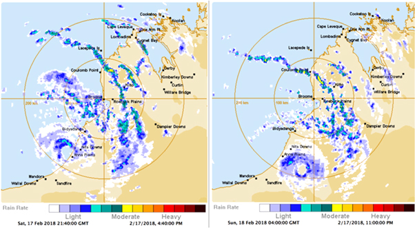
Figure 1. Broome Radar on 17 February 2018 at 2140 UTC and 18 February at 0400 UTC (Source: Australian Bureau of Meteorology).
Download figure:
Standard image High-resolution imageAndersen et al (2013) employed the HYDRUS-1D numerical water and heat flow model to simulate soil characteristics and surface energy fluxes over observed regions of TC intensification. Previous work has suggested that TCMIs are unique to Australia because of the ability of sandy soil to rapidly release huge amounts of energy when moistened (Emanuel et al 2008). However, Andersen et al (2013) found that in the regions where intensification was to occur, the latent heat flux (LHF) was highest in the afternoons/evenings and lowest in the mornings. For mean diurnal cycles, as solar radiation warmed the boundary layer throughout the day, evaporation increased along with the LHF. The overall LHF values were consistently higher in China and India. In the US and Australia, the LHF trend closely followed the precipitation trend due to the overall drier conditions. The daily maximums for all regions often reach 200 W m-2. The soil texture did not appear to have a significant effect on the LHF magnitudes across regions; however, the diurnal changes were sharper over Australia.
Yoo et al (2020) used a comprehensive modeling framework to conclude that the intensification of TC Kelvin was likely more related to atmospheric moisture advection and the diurnal cycle of solar radiation over land. While not convinced of a dominant Brown Ocean effect, they suggested that some possible land surface interactions were possible. Irrespective of mechanism, our research goal was to establish that TC Kelvin maintained a warm core structure as it traversed inland and during a secondary period of intensification. Section 2.0 summarizes our data and methodology, and section 3.0 presents results. Conclusions are presented in section 4.0.
2. Data and methodologies
2.1. Meteorological analysis
The radar presentation (figure 1) depicts Cyclone Kelvin on 17 February 2400 and 0400 GMT on 18 February, respectively. It is clear that the storm had an 'eye' inland, and qualitatively, it appears that the eye-eyewall structure is better organized inland. Global Precipitation Measurement (GPM) mission Level 3 Integrated Multi-satellitE Retrievals for GPM (IMERG) data is used to calculate Cyclone Kelvin's storm total precipitation (Huffman et al 2018). The IMERG algorithm combines satellite microwave precipitation estimates with gauge and other rainfall estimates at fine spatial and temporal scales to create high quality, global precipitation estimates. The Research/Final Run daily data at 0.1° spatial resolution are used to find the total accumulated precipitation from Kelvin's passage 17–20 Feb.
2.2. Reanalysis
The Global Data Assimilation System (GDAS) was a significant resource to analyze due to the sparsely available observations. GDAS data was used to develop composite analysis of near surface to upper atmospheric maps. The composite analyses were used to establish the upper level height and temperature fields associated with Cyclone Kelvin. Specifically, this part of the analysis was useful for establishing whether Kelvin was a warm-core system at the time that it seemed to intensify over land.
The Modern-Era Retrospective analysis for Research and Applications, Version 2 (MERRA-2) is a NASA-based reanalysis dataset that covers the satellite-observing period of 1980 to the present. The data set is on the order of 50 km in spatial resolution and is provided on regular grid. MERRA-2 provides a comprehensive suite of atmospheric and climate products (Bosilovich et al 2019). Using MERRA-2 data, the objectively defined three-dimensional cyclone phase space analysis of Hart (2003) was conducted. This technique uses information about storm symmetry and the thermal wind relationship. Specifically, thermal core (warm or cold) is identified over the life cycle of a storm based on vertical derivatives of the horizontal height surface gradients and the storm motion-relative thickness symmetry. This analysis can yield information on whether the system is warm core, cold core, or a hybrid.
3. Results
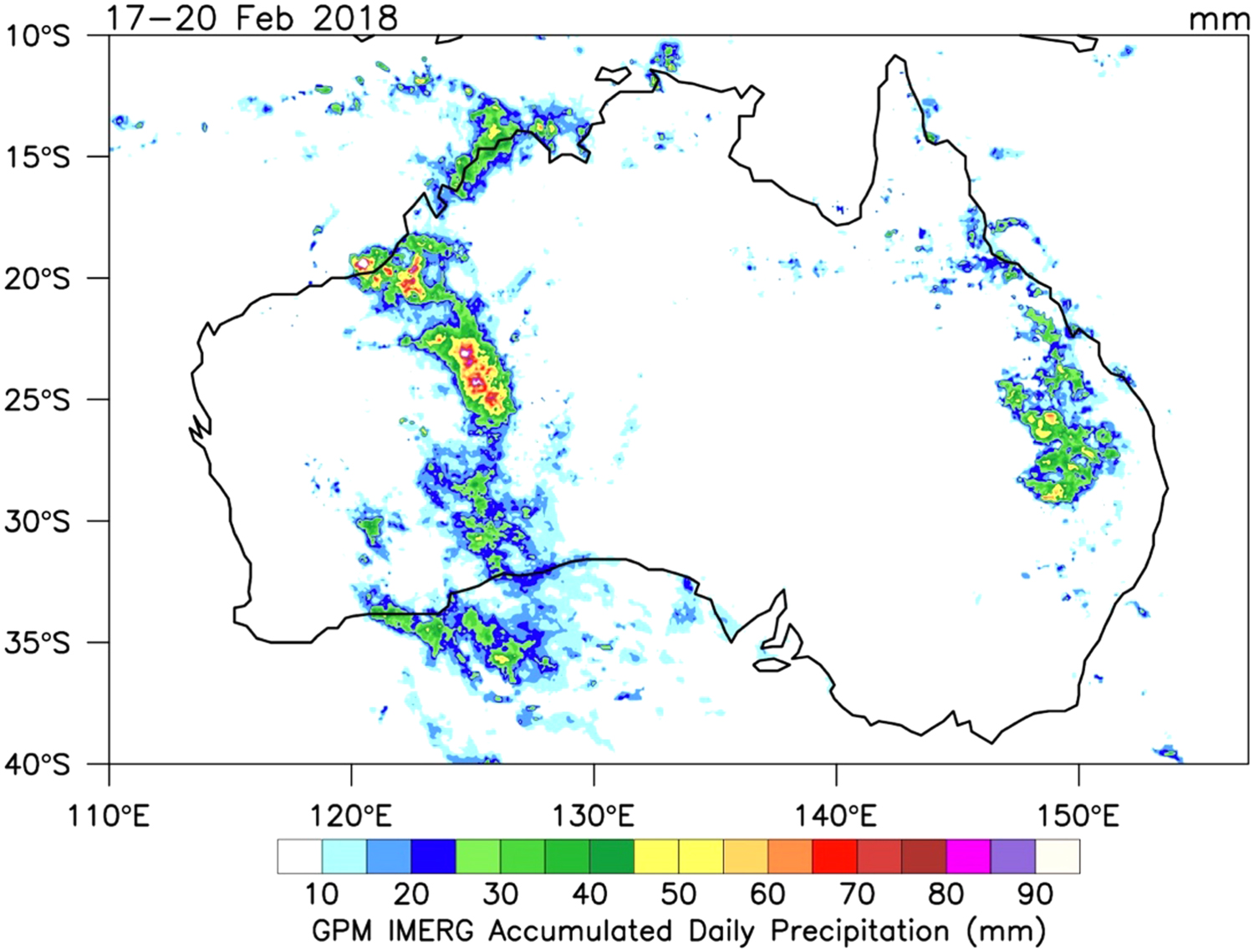
Cyclone Kelvin was the third tropical cyclone of the 2017/2018 season. It affected the east Pilbara and Kimberley regions of Australia over a 10-day period from 11 February to 21 February 2018. According to the Western Australian Regional Office of the Bureau of Meteorology, the storm originated as a tropical low at the tip of the Northern Territory on 11 February. The storm drifted east before taking a west-southwest track. The storm became Tropical Cyclone Kelvin at 2 pm AWST 17 February after spending time over land and ocean. Favorable atmospheric conditions allowed for development as the storm approached the coast in the Kimberly Region. The storm was classified as a category 2 system as it made landfall near Anna Plains Station at 8 am AWST on 18 February . The Bureau of Meteorology stated that the storm 'was intensifying as it crossed the coast.' The storm remained intact, perhaps even strengthened, for over 12 h before being downgraded on 19 February. Evidence of inland strengthening is evident in the IMERG satellite-derived rainfall product (figure 2). Two distinct maxima in rainfall are apparent—one close to the Northwest coast associated with the landfalling TC, and a second, inland maximum near 25 °S latitude corresponding to Kelvin's inland intensification. This led to rapid flooding. The Bureau of Meteorology reported localized flooding and the closure of The Great Northern Highway.
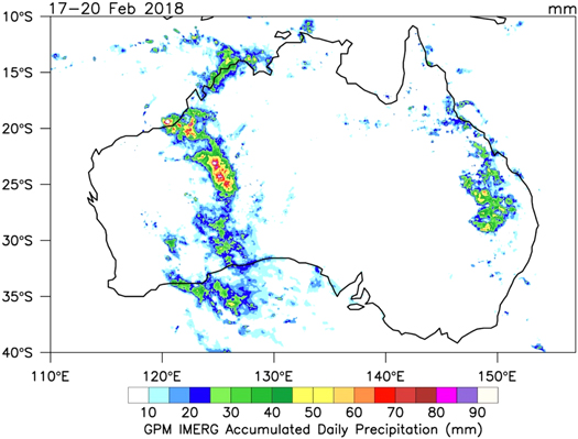
Figure 2. Rainfall 'footprint' of Cyclone Kelvin as measured by the NASA Global Precipitation Measurement Mission IMERG Product (Huffman et al 2018).
Download figure:
Standard image High-resolution imageThe period from landfall on 18 February to 19 February is of particular interest because the storm underwent a period of what Andersen and Shepherd (2013) referred to as tropical cyclone maintenance/intensification (TCMI). Given the presence of an eye feature and lower wind shear values, the next question posed was related to the warm-core structure of Cyclone Kelvin. A warm-core thermal structure is a defining
characteristic of tropical cyclones (Zhang and Chen 2012). The warm core is a product of the latent heat release associated with both condensation and freezing within eyewall convection (Halverson et al 2006). Adiabatic warming associated with subsidence in and near the center of the storm is also a contributor to the signature warm-core structure. Warm core systems are very different than transitioning baroclinic systems (Bosart and Bartlo 1991). Monteverdi and Edwards (2010) noted that warm core systems are associated with surface low pressure areas weakening with height but with vertical stacking at successive height levels.
To investigate whether Cyclone Kelvin had a warm-core structure over land, GDAS was used to compute a composite analysis (figure 3) of geopotential height and temperature at 850 hPa, 500 hPa, and 300 hPa, respectively. The composite analysis spanned the period of 17 February (0000 UTC) to 18 February (1200 UTC). Interestingly, the warm-core structure appears to be more concentrated and intense once the storm makes landfall and moves inland. This suggests that not only was the storm warm-core, it was also intensifying.
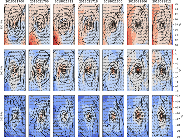
Figure 3. Composite of geopotential heights (dm) and temperature (degrees C) at 850, 500, and 300 hPa, respectively.
Download figure:
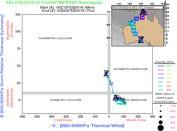
Standard image High-resolution imageHowever, the most compelling evidence for the warm-core structure comes from a cyclone phase space analysis (Hart 2003). This methodology has been extensively employed in the assessment of extratropical transitions (Bieli et al 2019) but has not been employed in studies to assess potential land surface interactions or warm core maintenance over land. This analysis technique quantifies the cyclone phase (e.g., warm core, cold core, hybrid) using three fundamental measures: (1) the storm motion relative 900–600 hPa thickness gradient across the cyclone (i.e., 'B'), (2) the magnitude of cyclone lower troposphere (900–600 hPa) thermal wind (i.e., -VT L), and (3) the magnitude of middle/upper troposphere (600–300 hPa) thermal wind.
The B parameter, shown on the y-axis in figure 4 gives a measure of the strength to which frontal boundaries drive the cyclone. Values of B much greater than zero suggest strong temperature gradients characteristic of an extratropical cyclone whereas values near zero indicate non-frontal cyclone. The thermal wind gives insight into the vertical structure of the cyclone. A thermal wind magnitude greater than zero suggests cyclone strength decreases with height, characteristic of a warm core system. Taken together, a storm that falls in the bottom right quadrant is non-frontal, warm core cyclone.
Figure 4. Cyclone phase space analysis of TC Kelvin (2018). A represents the incipient stages of the storm. Z represents the declining stages of the storm.
Download figure:
Standard image High-resolution image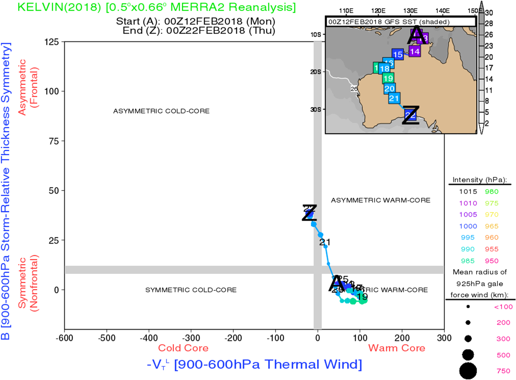
During much of the lifecycle of TC Kelvin, it is clear that it resides in the symmetric warm-core region of the cyclone phase space. The analysis clearly identifies the episodic intensification periods and the transition to a cold-core (or extratropical) system well after 21 February. It is also interesting to note the constriction of the mean radius of 925 HPa gale force winds during the inland phase of the storm, another potential sign of intensification or maintenance.
4. Conclusions and discussion
According to a stacked analysis of the pressure surfaces and a cyclone phase space analysis, TC Kelvin was a warm-core, tropical system undergoing intensification as it moved inland and the environment was quasi-barotropic. As noted earlier, Emanuel et al (2008) found that vertical heat fluxes from wet, hot sandy in this region could lead to intensification through land-atmosphere feedbacks. Extratropical transitioning (ET) was ruled out as a source of intensification, and it is beyond the scope of this paper to speculate on whether a 'Brown Ocean Effect' was apparent. Yoo et al (2020) suggested that TC Kelvin was able to maintain its warm core structure after its landfall for several days primarily due to the low-level atmospheric moisture advection from the ocean. Microwave satellite observations (not shown) did indicate a rather robust convective burst in the northwest segment of the eyewall, which could be explained by the advected moisture plume. Further numerical modeling studies will be required to evaluate role of moisture advection and surface fluxes on the warm core structure of Cyclone Kelvin.
Acknowledgments
This study was supported by NASA Modeling, Analysis and Prediction Program under the administration of Dr David Considine. Federal Award ID: 80NSSC17K0264. The authors are also grateful to Dr Bob Hart for his assistance with the Phase-Space diagrams.
Data availability statement
The data that support the findings of this study are openly available at the following URL/DOI:http://moe.met.fsu.edu/cyclonephase/.
Conflict of interest statement
The authors declare that there are no conflicts of interest.
Author contributions
J Marshall Shepherd analyzed data and drafted the majority of the manuscript. Andrew Thomas did the composite analysis. Patricia Lawston-Parker did the GPM rainfall analysis. Joe Santanello and Jeff Basara provided scientific insight and writing on land-surface and physical process interpretation. All authors reviewed and edited the manuscript.