


Introduction
Wetlands, in particular coastal wetlands such as estuaries, are among the most biodiverse habitats, but also among those most threatened by human activities (Lotze et al. Reference Lotze, Lenihan, Bourque, Bradbury, Cooke and Kay2006). These areas provide a wide range of ecosystem services that translate into important health and economic revenues for human populations, and yet 65% of the wetlands in the world have disappeared during the last century (Davidson Reference Davidson2014). Estuaries have long attracted human populations, as their strategic location makes them highly suitable as hubs of marine and riverine transportation and international commerce. Airports are also often built in the vicinity of estuaries, likely because part of these areas (mudflats and immersed areas) are left undeveloped, have a flat topography, and may thus provide lower building costs as well as aircraft approaches involving less risk to humans in comparison with highly developed areas (Adams and Lindsey Reference Adams and Lindsey2010). However, bird collisions with aircraft are an ever-growing problem to aviation, being responsible for the deaths of more than 400 people and the destruction of c.300 aircraft since 1912 (Richardson and West Reference Richardson and West2000, Thorpe Reference Thorpe2012). Strikes are much more likely to occur in areas with high bird densities, and/or with species with large size and flocking behaviour such as gulls (Laridae), waders (Charadrii) and waterfowl (Anseridae; Dolbeer et al. Reference Dolbeer, Wright and Clearly2000, Thorpe Reference Thorpe2008), which are typically abundant in estuaries. Thus, placing airports close to wetlands is, from the flight safety point of view, considered a risky decision (Hart et al. Reference Hart, Colyer and Allan2009, Lourenço and Alves Reference Lourenço and Alves2009, Coccon et al. Reference Coccon, Zucchetta, Bossi, Borrotti, Torricelli and Franzoi2015).
The number of birds involved in strikes is usually low, so the impact of these events on bird conservation is less important than on aircraft safety. The major conservation concern regarding airports near estuaries is related to the effects of disturbance caused by aircraft overflights and by measures used to scare and/or control bird numbers. These can be responsible for degradation of habitat quality (through bird avoidance of disturbed areas), lower feeding performance and increased energy expenditure due to escape flights, all of which could potentially drive population declines (Jensen Reference Jensen1990, Smit and Visser Reference Smit and Visser1993, Ward et al. Reference Ward, Stehn and Derksen1994, Conomy et al. Reference Conomy, Dubovsky, Collazo and Fleming1998, van der Kolk et al. Reference van der Kolk, Krijgsveld, Linssen, Diertens, Dolman, Jans, Frauendorf, Ens and van de Pol2020). Bird responses to aircraft activity are variable, depending on aircraft characteristics (type and size of aircraft, noise emitted, distance, angle of approach), terrain features (topography, land cover), bird species and species-specific traits (age, life history stage, flocking behaviour, individual fitness, among others; e.g. Ward et al. Reference Ward, Stehn, Erickson and Derksen1999, Komenda-Zehnder et al. Reference Komenda-Zehnder, Cevallos and Bruderer2003, Smit and Visser 2003, Smit and Visser 2003). Bird displacement to less disturbed 5 neighbouring areas (if available) can be a suboptimal alternative if they represent marginal or low-quality habitats, or if birds are forced to occupy areas already used by other birds, thus increasing competition and likely decreasing food intake (Gill et al. Reference Gill, Norris and Sutherland2001, Rutten et al. 2010). Although the loss or decrease in the quality of foraging and roosting sites for waterbirds due to aircraft disturbance is widely acknowledged (Komenda-Zehnder et al. Reference Komenda-Zehnder, Cevallos and Bruderer2003, Smit and Visser 2003, van der Kolk et al. Reference van der Kolk, Krijgsveld, Linssen, Diertens, Dolman, Jans, Frauendorf, Ens and van de Pol2020), the quantification of such losses to the overall conservation value of impacted areas is often prevented due to lack of accurate biological data. Yet, such an evaluation can be particularly important to improve airport siting (Zhao et al. 2019), adding key information to balance the sustainable development of airports and bird conservation.
After the consideration of 17 alternative locations during the last 50 years, in 2020, following the release of a conditioned but favourable Environment Impact Statement (EIS; APA 2020), the Portuguese government approved the construction of the new Lisbon international airport within one of the most important wetlands in Europe, the Tagus estuary. The new airport is planned for Montijo (Figure 1), on the East side of the Tagus river, reforming an area presently occupied by the Montijo Air Force Base. The Tagus estuary is a key site for wintering and migratory waterbirds along the East Atlantic Flyway, with a large part of its area classified as Nature Reserve (RNET) and Special Protection Area (SPA), included in the Natura 2000 network. It is also classified as internationally important under the Ramsar Convention for supporting more than 1% of the wintering biogeographic populations of several shorebird species, namely Avocet Recurvirostra avosetta, Black-tailed Godwit Limosa limosa, Grey Plover Pluvialis squatarola, Dunlin Calidris alpina, Ringed Plover Charadrius hiaticula, Bar-tailed Godwit Limosa lapponica, and of the breeding population of Black-winged Stilt Himantopus himantopus (Delany et al. Reference Delany, Scott, Dodman and Stroud2009). Another 13 waterbird species of geese, ducks, herons, egrets, flamingos, spoonbills, storks, terns, and several species of waders, have either wintering or breeding populations that meet the criteria for Important Bird and Biodiversity Area (IBA) (Wetlands International and BirdLife International 2020). The estuary is also an important stopover site for many other species during the pre- and post-breeding migration (Catry et al. Reference Catry, Alves, Andrade, Costa, Dias, Fernandes, Leal, Lourenço, Martins, Moniz, Pardal, Rocha, Santos, Encarnação and and Granadeiro2011, Reference Catry, Lourenço and Granadeiro2018, Lourenço et al. Reference Lourenço, Alonso, Alves, Carvalho, Catry, Costa, Costa, Dias, Encarnação, Fernandes, Leal, Martins, Moniz, Pardal, Rocha and and Santos2018). In some years it holds c.40% of the western European population of Black-tailed Godwit during the spring migration period (Lourenço et al. Reference Lourenço, Kentie, Schroeder, Alves, Groen, Hooijmeijer and Piersma2010). Wintering populations of several shorebird species have shown short-term (10 years) and long-term (30 years) declines, likely due to local factors, such as the loss and degradation of roost sites as a result of increasing human activity (Catry et al. Reference Catry, Alves, Andrade, Costa, Dias, Fernandes, Leal, Lourenço, Martins, Moniz, Pardal, Rocha, Santos, Encarnação and and Granadeiro2011, Lourenço et al. Reference Lourenço, Alonso, Alves, Carvalho, Catry, Costa, Costa, Dias, Encarnação, Fernandes, Leal, Martins, Moniz, Pardal, Rocha and and Santos2018). Many of these species are also facing declines at the flyway or global scales, as the network of suitable wetlands they depend on is shrinking at a rapid pace (International Wader Study Group 2003, Delany et al. Reference Delany, Scott, Dodman and Stroud2009, Studds et al. Reference Studds, Kendall, Murray, Wilson, Rogers, Clemens, Gosbell, Hassell, Jessop, Melville, Milton, Minton, Possingham, Riegen, Straw, Woehler and Fuller2017, van Roomen et al. Reference van Roomen, Nagy, Citegetse and Schekkerman2018).

Figure 1. Map of the Tagus estuary depicting the foraging (intertidal flats) and roosting (saltmarshes and saltpans) areas for shorebirds, the location of the new approved international Lisbon airport, and the boundaries of the Special Protection Area for Birds (SPA) and the Tagus Estuary Nature Reserve (RNET). High-tide roosts with larger dots are those holding overall higher bird numbers (Lourenço et al. Reference Lourenço, Alonso, Alves, Carvalho, Catry, Costa, Costa, Dias, Encarnação, Fernandes, Leal, Martins, Moniz, Pardal, Rocha and and Santos2018). Flight cones of the aircraft will cross the estuary from north to south.
The Environmental Impact Assessment (EIA) report that resulted in the favourable EIS for the new Lisbon airport recognized the impact on shorebirds as the most significant of the entire project (Profico Ambiente e Ordenamento 2019). Therefore, a significant part of the resulting report was devoted to analysing the potential impacts of this infrastructure on shorebirds and identified the noise of aircraft as the most serious threat. The public consultation of the EIA disclosed several weaknesses in the way this particular topic was addressed, concerning the subjectivity of the magnitude of the impact on each species and, more importantly, inaccuracies in the quantification of the impact of different noise levels on shorebirds. There is a relevant error in the EIA regarding the correspondence of the disturbance levels and the noise thresholds, which were incorrectly derived from Wright et al. (Reference Wright, Goodman and Cameron2010). Indeed, the EIA classifies a disturbance event as “strong” when the probability of behavioural response of birds is higher than 47%, but incorrectly attributes a value of 75 dB to such a probability (the value should be 65 dB, based on Wright et al. Reference Wright, Goodman and Cameron2010). The EIA report also lacked an analysis weighting either the local or global conservation status of each species.
The analyses on the effect of noise on shorebirds presented in the EIA report were carried out using a comprehensive dataset of shorebird abundance and distribution during the winter in the whole intertidal estuarine area collected by our team in the early 2000s (Granadeiro et al. Reference Granadeiro, Santos, Dias and Palmeirim2007). In this study, we re-analyse these data to produce a quantitative assessment of the potential loss of conservation value of intertidal areas of the Tagus estuary for wintering shorebirds due to the disturbance caused by aircraft traffic associated with the planned new Lisbon airport. We first identified priority areas for conservation using a spatial prioritization approach and then performed a replacement cost analysis by excluding the areas likely to be severely underused by birds due to intense air traffic noise (Wright et al. Reference Wright, Goodman and Cameron2010). The results of this analysis contribute to understanding whether the areas affected by noise are replaceable or if there is a significant loss in the conservation value of the estuary.
Methods
Study area
The Tagus estuary (38°45’N, 9°00’W) is one of the largest wetlands in Western Europe, with an approximate area of 340 km2. The intertidal area covers about 100 km2 and is mostly composed of mudflats with smaller areas dominated by sandy sediments and oyster beds. Bordering the estuary, extensive saltmarshes and saltpans (mainly abandoned or transformed into aquacultures) are used by shorebirds mostly as high-tide roosts (Catry et al. Reference Catry, Alves, Andrade, Costa, Dias, Fernandes, Leal, Lourenço, Martins, Moniz, Pardal, Rocha, Santos, Encarnação and and Granadeiro2011). An increasing area of rice fields (c.45 km2) occupies the north-eastern part of the estuary, providing additional feeding grounds for some shorebird species. The estuary margins are strongly developed except in the north-east, where extensive saltmarshes and agricultural fields dominate. Major habitats of the estuary and boundaries of the Nature Reserve (RNET), Special Protection Area (SPA) and Important Bird and Biodiversity Area (IBA) are depicted in Figure 1.
The new Lisbon airport is planned for the East side of the Tagus river, in an area presently occupied by the Montijo Air Force Base, close to the town of Montijo (Figure 1). This area is adjacent to the Tagus estuary SPA border, and therefore intense aircraft traffic flying at low altitudes during both approach and take-off is expected over the heart of the estuary (and over the SPA and RNET). In fact, the flight cones of the aircraft will cross the estuary from north to south, along its central axis, mainly over intertidal flats but also roosting areas (Figures 1, 2). The new airport will operate between 06h00 and 24h00, with an estimated number of 24 flights per hour.
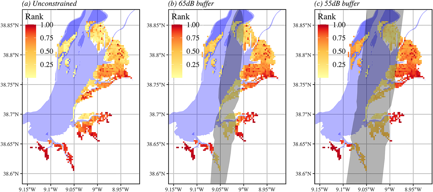
Figure 2. Priority rank maps of the foraging shorebirds in the Tagus estuary as identified by Zonation software in three different scenarios: (a) the current unconstrained optimal solution (depicting the baseline distribution of the pixel ranks in terms of conservation value), and the constrained suboptimal solutions in which one forces pixels within the 65dB (b) and 55 dB (c) noise buffers to be removed first, regardless of their value, under a scenario of a full operating Montijo airport. Higher rank values represent areas with higher conservation value. In (b) and (c) the area shaded in grey represent the 55 dB and 65 dB noise buffers, respectively.
No systematic studies have investigated the impact of aircraft activity from the Air Force Base of Montijo upon roosting or foraging shorebirds. However, anecdotal records collected in the scope of other studies suggest that in high-tide roosts shorebirds frequently react to military aircraft with alarm flights, sometimes leaving the roosting area (authors’ pers. obs.).
Shorebird surveys
We analysed low-tide shorebird (including waders, gulls, and egrets) counts carried out from December to mid-March in both 2002 and 2003, i.e. covering most of the wintering period. There is no evidence that the distribution of foraging shorebird has changed during the last 20 years, as there were no major changes in intertidal habitats and the relative importance of roosting sites is also stable (Lourenço et al. Reference Lourenço, Alonso, Alves, Carvalho, Catry, Costa, Costa, Dias, Encarnação, Fernandes, Leal, Martins, Moniz, Pardal, Rocha and and Santos2018, authors’ unpubl. data), and so this dataset still represents the best available information on the area. In 2003, all the intertidal area within the estuary was covered, while the 2002 survey was confined to the northern area included in the SPA (roughly 73% of the total intertidal area). Counting sectors (triangular areas with c.3.75 ha) were marked prior to the counts using a grid of canes placed with the help of a GPS in the whole inner estuary. On counting days, the centre of the area was reached by boat during the receding tide, and at low water two observers equipped with binoculars slowly walked in opposite directions along a transect on the edge of the sectors, counting all foraging birds present in each sector. The total area counted during a single day by the two observers consisted of a rectangle of 2.5 km x 1.2 km (300 ha). The intertidal areas located near the coast or close to the main channels were divided into sectors of irregular shape and size using landmarks, and counted with binoculars or a telescope, normally from distant vantage points on the coast. All counts were performed at spring tides (low-water tidal height <1 m) within the period of two hours before and after low-tide peak (see Granadeiro et al. Reference Granadeiro, Santos, Dias and Palmeirim2007 for further details).
The boundaries of all sectors and the corresponding count data were entered in a Geographical Information System (GIS) and the densities of birds (expressed as number of birds per 10 ha) were computed after calculating the area of each sector (see Granadeiro et al. Reference Granadeiro, Santos, Dias and Palmeirim2007 for further details). Counting sectors were transformed in a regular grid of plots measuring 250 m x 250 m and data from 2002 and 2003 surveys were combined (bird densities were averaged for sectors counted in both years) to produce a geo-referenced abundance map for each species (raster files in Appendix S1 and Figure S1 in the online supplementary material).
Potential disturbance at high-tide roosts was not addressed in this study as our methodology, aiming to deliver a value of conservation loss for the whole estuary, is not appropriate for roosting shorebirds which have a discrete distribution on the few high-tide roosts scattered around the Tagus estuary. In addition, although we could potentially estimate the proportion of roosting birds impacted by aircraft flights, it is virtually impossible to assess the impacts over foraging and (on the same) roosting birds, as the amount of redundancy can hardly be quantified. Shorebird distribution data for the migratory periods are not available for the whole foraging areas of the estuary and were thus also not addressed here.
Spatial conservation prioritization and replacement cost analysis
We used Zonation 4.0 software (Moilanen et al. Reference Moilanen, Pouzols, Meller, Veach, Arponen, Leppanen and Kujala2014) to identify priority areas for shorebird conservation within the intertidal flats of the Tagus estuary and then quantify the conservation value loss of the estuary in a scenario of a fully operational new airport. Zonation software has been widely used to delineate conservation priorities and assess impacts of potential habitat loss (e.g. Kujala et al. Reference Kujala, Whitehead and Wintle2015, Di Minin et al. Reference Di Minin, Slotow, Hunter, Pouzols, Toivonen, Verburg, Leader-Williams, Petracca and Moilanen2016).
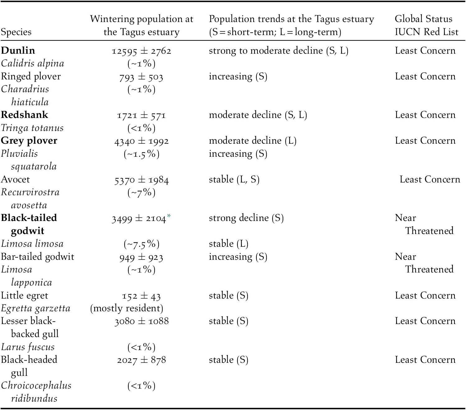
The distribution maps of the 10 most abundant species (Table 1) obtained from bird surveys were imported into Zonation. Each species distribution raster was assigned a specific conservation weight, based on the local wintering population trends. More specifically, we assigned twice the conservation weight to Dunlin, Black-tailed Godwit, Redshank Tringa totanus and Grey Plover, which experienced population declines in the Tagus estuary (despite recent increases in numbers for Grey Plovers; Catry et al. Reference Catry, Alves, Andrade, Costa, Dias, Fernandes, Leal, Lourenço, Martins, Moniz, Pardal, Rocha, Santos, Encarnação and and Granadeiro2011, Lourenço et al. Reference Lourenço, Alonso, Alves, Carvalho, Catry, Costa, Costa, Dias, Encarnação, Fernandes, Leal, Martins, Moniz, Pardal, Rocha and and Santos2018; Table 1). Zonation software uses an algorithm that takes each spatial unit (cell) in the abundance raster map and hierarchically ranks it based on its conservation value (Moilanen Reference Moilanen2007). Beginning at the edge of the map, Zonation iteratively identifies the cells that cause the minimal marginal loss in the conservation value of the remaining landscape and removes them following a specific cell removal rule (see below; Moilanen Reference Moilanen2007). The order in which the cells are removed represents the hierarchy of the cells in the landscape: the best 1% of the cells in the landscape are the 1% of cells retained by the algorithm when 99% of the landscape has been removed. In the resulting hierarchic map, the top 1% fraction is nested within the top 10% fraction, which is nested within the 20% fraction and so forth.
Table 1. Mean number (± SD), trends of wintering populations and global conservation status (IUCN 2020) of the 10 shorebird species included in the Zonation analysis based on high-tide roost counts at the Tagus estuary. The percentage of the biogeographic population that each mean count represents is shown between parentheses below the wintering population (based in Delany et al. Reference Delany, Scott, Dodman and Stroud2009, except for the gulls, which followed van Roomen et al. Reference van Roomen, Nagy, Citegetse and Schekkerman2018). Mean numbers refer to counts performed during the winter period (December to February) between 2012 and 2015, except for Little Egret, Lesser Black-backed Gull and Black-headed Gull for which counts were carried in January between 2007 and 2016 (data from Lourenço et al. Reference Lourenço, Alonso, Alves, Carvalho, Catry, Costa, Costa, Dias, Encarnação, Fernandes, Leal, Martins, Moniz, Pardal, Rocha and and Santos2018). Long- and short-term population trends were obtained from Catry et al. Reference Catry, Alves, Andrade, Costa, Dias, Fernandes, Leal, Lourenço, Martins, Moniz, Pardal, Rocha, Santos, Encarnação and and Granadeiro2011 and Lourenço et al. Reference Lourenço, Alonso, Alves, Carvalho, Catry, Costa, Costa, Dias, Encarnação, Fernandes, Leal, Martins, Moniz, Pardal, Rocha and and Santos2018, respectively. Species showing either short- or long-term declines in the Tagus estuary, and were thus assigned twice the conservation weight in the zonation analysis, are highlighted in bold.
* subspecies L. l. islandica
In order to carry out our multi-species assessment and estimate the Tagus estuary key conservation areas, we adopted the Additive Benefit Function (ABF) cell removal rule (Moilanen Reference Moilanen2007). Using ABF, the marginal loss is calculated as the sum of the species-specific decline in conservation value of the landscape after the removal of each cell, while accounting for the different conservation weights assigned to each species. In brief, for each cell i and each species j, the ABF cell removal rule computes each cell’s marginal loss (δi) based on each species’ conservation weight (wj) and the benefit function Vj:
 $$ {\unicode{x03B4}}_{\mathrm{i}}={\mathrm{w}}_{\mathrm{j}} \ast \hskip1.5pt {\varSigma}_{\mathrm{j}}\varDelta {\mathrm{V}}_{\mathrm{j}} $$
Vj is the benefit function, that by default is a power function with exponent 0.25 (Moilanen et al. Reference Moilanen, Pouzols, Meller, Veach, Arponen, Leppanen and Kujala2014). More specifically:
 $$ \varDelta {\mathrm{V}}_{\mathrm{j}}={\mathrm{V}}_{\mathrm{j}}\left({\mathrm{f}}_{\mathrm{j}}\right)-{\mathrm{V}}_{\mathrm{j}}\left({\mathrm{f}}_{\mathrm{j}}-{\mathrm{f}}_{\mathrm{j}\mathrm{i}}\right)={\left({\mathrm{f}}_{\mathrm{j}}\right)}^{0.25}-{\left({\mathrm{f}}_{\mathrm{j}}-{\mathrm{f}}_{\mathrm{j}\mathrm{i}}\right)}^{0.25} $$
where fj is the fraction of the total distribution of species j remaining in the landscape and fji is the fraction of the total distribution of species j occurring in cell i. Thus, ABF assigns higher values to the locations that are important to multiple species, which was considered the ideal approach for the simultaneous evaluation of the 10 species abundance maps.
In order to induce aggregation in the final priority areas map and penalise the creation of very small patches, we implemented the Boundary Quality Penalty (Lehtomäki and Moilanen Reference Lehtomäki and Moilanen2013, Moilanen et al. Reference Moilanen, Pouzols, Meller, Veach, Arponen, Leppanen and Kujala2014). This method quantitatively accounts for the species-specific responses to habitat loss and fragmentation by allowing the conservation value of a focal cell to be diminished in proportion to the loss of neighbouring cells. For our purposes, we assumed all species to show equal response curves to habitat loss and set the cell neighbourhood size to the eight cells surrounding each focal cell. We defined conservative fragmentation response curves in which the biological value of a focal cell halved as its neighbourhood habitat had been completely lost (Moilanen et al. Reference Moilanen, Pouzols, Meller, Veach, Arponen, Leppanen and Kujala2014).
After developing a priority ranking for the entire intertidal area, we performed a replacement cost analysis (Kukkala and Moilanen Reference Kukkala and Moilanen2013, Lehtomäki and Moilanen Reference Lehtomäki and Moilanen2013, Moilanen et al. Reference Moilanen, Pouzols, Meller, Veach, Arponen, Leppanen and Kujala2014), excluding the areas likely to be underused by birds due to intense air traffic noise. For this analysis, noise thresholds were set based on the study by Wright et al. (Reference Wright, Goodman and Cameron2010), the only published study which modelled the relationship between the decibel (dB) level experienced by shorebirds and their behavioural response (vigilance, alarm calls, flight). Although Wright et al. (Reference Wright, Goodman and Cameron2010) used an air horn to produce an impulsive noise rather than a more chronic disturbance event, such as that resulting from the aircraft traffic of the new airport, the study used noise levels within the range of those expected to occur in the Tagus estuary. Moreover, the group of species included in the study of Wright et al. (Reference Wright, Goodman and Cameron2010), which included waders and gulls, was the closest to our own range of species, which seems to be of relevance, since bird responses to noise disturbance were shown to vary widely among species (e.g. Wright et al. Reference Wright, Goodman and Cameron2010, McClure et al. Reference McClure, Ware, Carlisle, Kaltenecker and Barber2013). According to Wright et al. (Reference Wright, Goodman and Cameron2010), within the 55–65 dB noise interval, the probability of birds showing one of the mentioned behavioural response varies between 5% and 47%. Raising noise levels over 65 dB increases the probability of response to >47%.
After running the Zonation analysis to identify priority areas for shorebirds (hereafter “unconstrained” analysis), we computed two new “constrained” analyses by forcing out from the estuarine landscape the cells falling within a 55 dB and 65 dB noise buffers predicted for a scenario of a fully operational Montijo airport (the buffers were digitalized from the EIA; Profico Ambiente e Ordenamento 2019). In other words, we forced Zonation algorithm to first remove the cells within the noise buffers, regardless of their conservation value, and then compute a new (suboptimal) solution (Moilanen et al. Reference Moilanen, Pouzols, Meller, Veach, Arponen, Leppanen and Kujala2014). Our assumption is that birds will not use the areas characterized by intense noise and will redistribute elsewhere in the remaining portions of the landscape. The percentage of conservation value lost in the constrained solutions corresponds to the reduction in the proportion of high-quality areas for shorebirds remaining in the landscape after we removed the areas in the 55 dB and 65 dB buffers. This value compares to the solution achieved if we had removed the same area extent but removing the “least valuable” areas (corresponding to the unconstrained solution, which would cause the least marginal loss).
Results
The ranking of priority intertidal areas classified by Zonation in both the “unconstrained” (and “constrained” analyses are presented in Figure 2. In the unconstrained solution, the top 25% most valuable areas of the landscape are almost entirely concentrated to the south of the study area. The situation changes drastically in the fully operating Montijo airport scenario, when either a 65 dB or a 55 dB noise buffer around the take-off/landing strips are forced out from the landscape. Of the total area used by foraging shorebirds, approximately 50% and 26% overlap with the 55 dB and 65 dB noise buffers, respectively (Figure 2). Moreover, the 55 dB and 65 dB buffers overlap, respectively, with 54% and 29% of the top quartile conservation priority intertidal areas as classified by unconstrained Zonation. When the areas within the 55 dB or 65 dB buffers are forced out from the available landscape, most of the key areas at the south forcibly receive low conservation priority, and Zonation identifies new (previously suboptimal) priority conservation areas to the east-northeast (Figure 2b-c). As a consequence, the foraging areas for shorebirds in the Tagus estuary are likely to suffer a loss in conservation value between 21% and 30%, respectively, as indicated by the replacement conservation cost analysis (Figure 3). This means that the exclusion of the area impacted by the noise is 21% (55 dB) and 30% (65 dB) worse than a scenario of loss of an equivalent (same dimension) area, should one be able to select the least interesting areas for the shorebird assemblage (which is depicted in Figure 2a).

Figure 3. Replacement cost analysis output. The curves show how the proportion of shorebird species distribution retained in the analysis changes as cells are progressively removed from the estuarine landscape. In the unconstrained solution, cells that cause the least marginal loss are removed first. In the two constrained solutions (scenario of a full operating Montijo airport), the cells falling within the 55 dB or 65 dB noise buffers are masked out from the landscape and forcibly removed first (despite their high conservation value, see map in Figure 2a). The removal of these unreplaceable cells causes a drop of 21% to 30% in the conservation value of the whole area.
Discussion
Habitat loss and degradation, mainly as a result of human disturbance and land use changes, ranks high in the list of factors driving declines in shorebird populations worldwide (e.g. International Wader Study Group 2003, Delany et al. Reference Delany, Scott, Dodman and Stroud2009, Studds et al. Reference Studds, Kendall, Murray, Wilson, Rogers, Clemens, Gosbell, Hassell, Jessop, Melville, Milton, Minton, Possingham, Riegen, Straw, Woehler and Fuller2017, van Roomen et al. Reference van Roomen, Nagy, Citegetse and Schekkerman2018). Here, we show that the recently approved construction of the new Lisbon airport at Montijo will likely result in the loss of up to 30% of the conservation value of the Tagus estuary as a feeding ground for wintering shorebirds. This estimate is exclusively based on the predicted behavioural response of shorebirds facing different noise scenarios expected to occur during aircraft landing and take-off. In the "high tolerance" scenario, where the response to noise occurs only in the 65 dB buffer, the loss in conservation value is equal to 21%, while in the "low tolerance" scenario (55 dB buffer), the loss increases to 30%. This high replacement cost strongly indicates that the areas more strongly affected by the operation of the airport are not replaceable by selecting alternative solutions (Moilanen et al. Reference Moilanen, Arponen, Stokland and Cabeza2009, Kukkala and Moilanen Reference Kukkala and Moilanen2013). While the lack of accurate data prevents an analogous evaluation focusing on (passage) migrant shorebirds, the overall impacts may be even more severe, both because they are more time- and energy-constrained by their schedules and physiological status (e.g. Newton Reference Newton2008), and because they are not familiarized with local habitat characteristics and sources of disturbance (see below; Martins et al. Reference Martins, Catry, Rebelo, Pardal, Palmeirim and Granadeiro2015).
Although this projection is based on a comprehensive dataset of foraging shorebird abundance and distribution in the Tagus estuary, there are a number of assumptions and potentially confounding variables that may influence our estimate of conservation value loss. Factors that could cause an overestimate of the loss in conservation value include (1) the assumption that birds will drastically reduce the use of intertidal areas with chronic noise levels of 55 dB and 65 dB and (2) not accounting for potential habituation of birds to noise levels. A few studies have quantified bird responses to different levels of impulsive (short duration “on/off” pulses) or chronic noise, but they show that responses may vary extensively among species, sites, and seasons, and with types and levels of sound (Gill et al. Reference Gill, Norris and Sutherland2001, Wright et al. Reference Wright, Goodman and Cameron2010, McClure et al. Reference McClure, Ware, Carlisle, Kaltenecker and Barber2013, van der Kolk et al. Reference van der Kolk, Krijgsveld, Linssen, Diertens, Dolman, Jans, Frauendorf, Ens and van de Pol2020), making generalizations rather difficult. Two experimental studies, which recorded changes in waterbird behaviour in response to noise produced by an air horn and aircraft overflights, showed stressful responses to occur at a sound threshold of 55 dB (5–47% of birds involved; Wright et al. Reference Wright, Goodman and Cameron2010), with c.47% (Wright et al. Reference Wright, Goodman and Cameron2010) to 80% (Komenda-Zehnder et al. Reference Komenda-Zehnder, Cevallos and Bruderer2003) of birds showing stress when noise reached values close to 65 dB. When assuming that birds at the Tagus estuary will drastically reduce the use of areas within the projected noise zone, we are assuming a stronger response than that predicted by Wright et al. (Reference Wright, Goodman and Cameron2010), where less than 5% and c.15% of the birds permanently abandon the disturbed area when facing noise levels of 55 dB and 65 dB, respectively. No details on different types of stressful responses are presented by Komenda-Zehnder et al. (Reference Komenda-Zehnder, Cevallos and Bruderer2003), but the authors state that most birds returned to a relaxed behaviour within five minutes after the overflights and recorded low levels of area desertion. However, in these experimental studies, birds were exposed to short periods of impulsive noise, while at the Tagus estuary noise is expected to be chronic, with one aircraft landing or taking off every 2.5 minutes. This disturbance frequency hardly allows shorebirds to return to the area they left (if they respond by flying) and/or to resume foraging behaviour between disturbance events, and may thus elicit a stronger response, such as the permanent desertion from the disturbed area. In addition, when facing disturbance events, birds are more likely to respond if there is suitable habitat present nearby to which they can retreat (Gill et al. Reference Gill, Norris and Sutherland2001), which is the case at the Tagus estuary, where we expect birds to permanently move from disturbed to non-disturbed areas. Lack of consensus from previous studies makes it difficult to assess the role of habituation in bird long-term responses to noise. Experimental studies suggest either no short-term habituation (Komenda-Zehnder et al. Reference Komenda-Zehnder, Cevallos and Bruderer2003), fast habituation (Conomy et al. Reference Conomy, Dubovsky, Collazo and Fleming1998) or were inconclusive (Ward et al. Reference Ward, Stehn, Erickson and Derksen1999), whereas some degree of long-term habituation was recorded in shorebirds in areas with aircraft activity (Smit and Visser Reference Smit and Visser1993). Nonetheless, there is overall agreement that birds are more likely to tolerate relatively predictable sources of disturbance and react more strongly to less predictable ones (Smit and Visser Reference Smit and Visser1993, Ward et al. Reference Ward, Stehn, Erickson and Derksen1999). Still, habituation does not imply that birds do not show stressful responses, but rather lower the level of such responses. In addition, whilst resident birds (or birds using the area for relatively long periods) have the opportunity to become familiarized with local disturbance, passage migrants may have no time for such habituation (Koolhaas et al. Reference Koolhaas, Dekinga and Piersma1993, Martins et al. Reference Martins, Catry, Rebelo, Pardal, Palmeirim and Granadeiro2015). The new Lisbon airport will not operate for several consecutive hours during the night period. Whether shorebirds will use foraging areas within the 55 dB and 65 dB noise buffers when aircraft activity is absent remains unknown.
On the other hand, there are also a number of variables, not accounted for in our analysis, suggesting that the 21–30% loss in the conservation value of the Tagus estuary is likely underestimated. Here, we considered losses in foraging areas that fall within the 55 dB and 65 dB noise buffers, but effects of disturbance on high-tide roosts are also known to have major consequences on the use of neighbouring feeding grounds (Dias et al. Reference Dias, Granadeiro, Lecoq and Palmeirim2006, Rogers et al. Reference Rogers, Battley, Piersma, Van Gils and Rogers2006). The projected new Lisbon airport lies adjacent to the most important roosting site for shorebirds in the Tagus estuary (Samouco saltpans; Catry et al. Reference Catry, Alves, Andrade, Costa, Dias, Fernandes, Leal, Lourenço, Martins, Moniz, Pardal, Rocha, Santos, Encarnação and and Granadeiro2011), where the levels of disturbance are expected to rise considerably. The degradation of this roost may impact the use of neighbouring feeding areas, as few birds forage more than 5 km from roost sites (Dias et al. Reference Dias, Granadeiro, Lecoq and Palmeirim2006) due to the high cost of commuting between areas twice a day (Rogers et al. Reference Rogers, Battley, Piersma, Van Gils and Rogers2006). The potential decline in the suitability of intertidal areas adjacent to the Samouco roost, which received high conservation values in our unconstrained analysis, may worsen the constrained scenarios. In fact, the lack of high-tide roosts in the north-west part of the estuary probably explains why its intertidal flats are underused by shorebirds (Dias et al. Reference Dias, Granadeiro, Lecoq and Palmeirim2006), thus receiving a low conservation value.
Noise was the disturbance source used to predict shorebird responses to aircraft flights in the EIA and in this study. Previous studies investigating aircraft disturbance on birds lack a separate analysis on the effects of noise and visual cues, as the two effects are extremely difficult to disentangle. Nonetheless, a recent study suggested that sound levels may not be the primary cause of aircraft disturbance, as birds responded to visible aeroplanes flying too far to be heard (van der Kolk et al. Reference van der Kolk, Krijgsveld, Linssen, Diertens, Dolman, Jans, Frauendorf, Ens and van de Pol2020). Therefore, considering noise as the sole source of disturbance could also have led to an underestimation of the impacts of aircraft in our study.
In this study, we used a methodological approach that delivers an estimate cost of precluding birds from using areas impacted by aircraft noise in regard to their relative importance within the whole estuary. Therefore, our study provides a quantitative indicator of loss, using an objective and replicable methodology, adding to the conclusions presented in the EIA which only identifies the proportion of birds and foraging areas that fall within noise buffers for which different disturbance levels were assigned (“no disturbance”, “low disturbance” and “strong disturbance”). In addition, and more importantly, the error in the EIA regarding the correspondence of the disturbance levels and the noise thresholds (incorrectly attributing a value of 75 dB instead of 65 dB to a behavioural response probability of 47% as proposed by Wright et al. Reference Wright, Goodman and Cameron2010) resulted in a serious underestimation of the number of birds and areas impacted within each disturbance class. Performing test flights in the study area, following the flight routes and aircraft altitudes predicted for the operating airport, in order to record shorebird disturbance responses (namely the percentage of birds of different species responding, flight distance responses, return time to the disturbed area) could further improve the accuracy of the estimated impacts achieved in the present study.
Conclusion
Half of all migratory populations of shorebirds are declining worldwide, mainly as a result of global changes promoted by human activities (Studds et al. Reference Studds, Kendall, Murray, Wilson, Rogers, Clemens, Gosbell, Hassell, Jessop, Melville, Milton, Minton, Possingham, Riegen, Straw, Woehler and Fuller2017, van Roomen et al. Reference van Roomen, Nagy, Citegetse and Schekkerman2018). During their challenging migratory journeys between high-latitude breeding areas and milder temperate and tropical wintering grounds, shorebirds depend on a network of high-quality sites that act as refuelling stops to accomplish these extraordinary flights (Delany et al. Reference Delany, Scott, Dodman and Stroud2009). Thus, the loss of one of such sites can have dramatic consequences for the whole flyway population. The Tagus estuary is among the most important wetlands for shorebirds in the East Atlantic Flyway (Delany et al. Reference Delany, Scott, Dodman and Stroud2009) and is legally protected under both national (Nature Reserve) and European legislation (SPA). We estimated that the implementation of the new Lisbon airport at the heart of the estuary may lead to a loss of up to 30% in the conservation value of this wetland for shorebirds. The predicted impacts are a violation of the commitments signed by the Portuguese government to safeguard wetlands and associated biodiversity, and the measures defined in the EIS to mitigate or compensate for these impacts (APA 2020) are in fact already largely comprised on those commitments. Conservation of migratory species needs international cooperation and thus the responsibilities of the Portuguese government extend beyond domestic borders.
Supplementary Materials
To view supplementary material for this article, please visit http://doi.org/10.1017/S0959270921000125.
Acknowledgements
We thank the many volunteers involved in shorebird counts as well as Reserva Natural do Estuário do Tejo (RNET) for all logistic support during fieldwork. Nicola Crockford, Henk-Jan van der Kolk and an anonymous reviewer provided helpful comments to improve an earlier version of this manuscript. This study was funded by Fundação para a Ciência e Tecnologia (FCT) through project “MigraWebs: Migrants as a seasonal ecological force shaping communities and ecosystem functions in temperate and tropical coastal wetlands” (ref. PTDC/BIA-ECO/28205/2017). Thanks are due to FCT/MCTES for the financial support to CESAM (UIDP/50017/2020 and UIDB/50017/2020), through national funds. TC and FV were supported by FCT through contract IF/00694/2015 and doctoral grant PD/BD/135537/2018, respectively.


