1. Introduction
Land is a source of material wealth; it provides people with resources to sustain on. It is also a major economic asset from which people and nations get significant profit. In many developing countries, land is considered as an important economic and social asset where the status and prestige of people is determined. Because of such a high importance given to land, as compared to other properties, the legal protection accorded to land is al-ways strict in nature [
1]. Due to this, strong institutions are established to administer and manage land. According to Holden, institutions are defined as systems of established and prevalent social rules that structure social interactions [
2]. Institutions play an important role in shaping socio-economic outcomes [
3]. For this to happen, institutions must be ef-fective and functional [
2]. The change in institutional arrangements, in many cases, was made in anticipation of a better land administration system [
4]. The United Nations Global Geospatial Information Management (hereinafter UN-GGIM) has affirmed in the Addis Ababa declaration for “Good Land Governance for Agenda 2030” that strong land administration institutions are required to support effective and efficient land administration and management to address the need to secure land and property rights for all [
5]. According to UN-GGIM institutional arrangement is defined as the formal and informal structures that support organizations to establish the legal, organizational and productive frameworks. This type of arrangement establishes the sustainable management of geospatial information, inclusive of its creation, updating and dissemination of geospatial data. This in turn provides an authoritative, reliable and sustainable geospatial information base for all users [
5]. Relevant institutional arrangements contribute to the strengthening of geospatial information management.
Theoretically, there are three types of institutional arrangements [
6]: hierarchy based, market based, and network based. Each type of institutional arrangements has its own mechanism to understand the causes of problems experienced, the gains to be achieved, and the processes through which better institutional arrangements can be achieved. In hi-erarchy-based institutional arrangements, patterns of interaction have two main drivers: (1) authority, operationalized in administrative orders, rules and planning, and (2) domi-nance and authority as the basic control system on the other. Market-based institutional arrangements are based on competition, bargaining and exchange between actors. Net-work-based institutional arrangements take the form of cooperation between actors, where inter-organizational relations are ruled by the acknowledgement of mutual interdepend-encies, trust, and the responsibilities of each actor. In this paper when we talk about insti-tutional arrangement, we are referring to the hierarchy-based type of arrangement. Institu-tional arrangements may be realized by creating new or changing existing structures or management forms within the government.
The importance of institutional arrangements in geospatial information management was recognized by the UN-GGIM at its third session in July 2013, when it identified the need for countries to examine institutional arrangements in geospatial information man-agement, and thereby provide governments with options on how best to create strong na-tional geospatial entities [
7]. One of the mechanisms to (re)arrange institutions is through merger, which assembles institutions having related tasks so that resources could be uti-lized on its best use [
8].
1.1. Rational Justification for Mergers
The rational justification and benefits of merger arises from different perspectives such as increasing institutional performance, improvement of customer service, efficient operation of land market [
9]. A merger is an agreement, based on voluntarily, which unites two or more existing institutions into one [
10]. There are several reasons why or-ganizations merge. When looking at mergers, it is important to look at the subject on a case by case basis as each merger has both merits and demerits [
11]. Mergers are mainly done to avoid duplication of responsibility across institutions [
9]. Avoiding duplication would have economic benefits and help reduce bureaucracies. This in turn increases in-stitutional performance and reduces misuse of resources. Due to this, mergers have re-ceived frequent and thorough study by researchers [
12]. The initiative to merge land regis-tration and cadaster institutions coined from FIG commission 7 where the research find-ings of 1994 show that the strategic management and operations of cadastral systems are vested in different organizations [
13]. Pursuing these research findings, cadaster 2014 vi-sion was articulated by directing emphasis on merger of the land registration and cadas-ter institutions. Their findings show (1) improvement of customer service with increased efficiency (2) provision of more data in better quality (3) provision of data that are suffi-ciently accurate (4) provision of data to the government and citizens at the right time. The most reiterated overarching importance of cadastral institutional rearrangement is to pro-vide efficient operation of the land market. Following this, many developed countries (e.g., Sweden, Finland, Netherlands, Turkey, and Belgium) followed the principle of merger. For instance, Sweden started the cadaster and registry merging in 2008. Following this, a study conducted to evaluate pre-merger and post-merger institutional performance was undertaken and the finding shows that an institutional merger brought institutional effec-tiveness [
14]. What is emerging is that while developed countries have moved on to mod-ern cadastral systems, majority of the countries in Africa are still stuck in the old tradi-tional systems although a few countries have embarked on the process of modernizing their cadaster in line with the internationally recognized benchmarks. These include; Rwanda, South Africa, Botswana, Lesotho, Ghana, and Ethiopia just to mention a few [
15,
16]. Among these, Rwanda is the only country in Africa that has succeeded in docu-menting all rights to land based on the Torrens System [
17]. Responsibility of all cadastral system activities are given to a single institution, called Office of the Registrar of Land Ti-tles. The system follows the international rules and standards such as cadaster 2014, and LADM [
18]. According to GoR Land Administration Manual [
18], the implementation of modern cadastral system in Rwanda has been started in 2007. In the first two years, prep-aration works, including public consultations and the development of the legal, institu-tional, and policy frameworks were embarked. On 2009, the actual a fully-fledged Sys-tematic Land Registration (SLR) work were started and completed in 2013 through nine stages: (1) Notification of LTR area and local information campaign; (2) Recruitment and training of local staff; (3) Parcel demarcation; (4) Land adjudication; (5) Data entry and checking; (6) Parcel digitization; (7) Objections and corrections; (8) Lease preparation; (9) Lease issuance. In realizing this registration, Rwanda has engaged the private sector in some specified cadastral activities. The cadastral system has been a very ambitious but also very successful. With this trend, all parcels that account 10.67 million are registered in less than 5 years. For this successful achievement, the London-based trade organization British Expertise awarded certificate of recognition being an Outstanding International Development Project. In this regard, the 2020 BD [
19] report ranked Rwandan cadastral system third in the world. In the case of cadastral system of South Africa, it is one of the best and most reliable systems. It accurately defined the boundaries of properties, and the positions of rights affecting those properties [
20]. Responsibility for cadastral system falls under the Department of Land Affairs [
15]. The primary function of the cadastral system in South Africa is to define (delineate and document) ownership rights. According to the Land Audit Report [
20] of South Africa, 94% of the total land in the country is registered digitally in the Deeds Office. In this regard, it can be said that much efforts has been in-vested in to overcoming the problems experienced in many developing countries where lack of cadastral information hinders development. Those illustrative cases show that the theory of merger is becoming acceptable for its effective performance.
1.2. Background and Context of the Study
The origins of the cadastral system in Ethiopia dated back to 1907 when Menilek II signed Ethiopia’s first decree related to urban land administration [
21,
22,
23]. It was by a French company that the cadastral system was introduced but remained without maintenance for more than 80 years [
24]. Even though, there was a sporadic effort to es-tablish a cadastral system some time ago in Addis Ababa, as it is not updated for a long time, it is almost non-existent as a system until very recently. Hence, the Addis Ababa City Administration around 1995 decided to launch a cadastral project initially intended to register all property owners liable for property taxation and collect data that would enable the city administration to assess property tax. However, the attempt was not effective which then changed in to establishing a multipurpose cadaster [
21]. Even though a step forward was achieved and some experiences were gained as a result of launching the ca-dastral project of 1995 of Addis Ababa, it was not possible to evaluate this project as a successful one due to varieties of reasons, which among others, lack of cooperation be-tween these cadastral system and land right creation institutions [
25].
Currently in Ethiopia, urban land is under the responsibility of Ministry of Urban Land Development, Housing and Construction (MULDHC). Within this institution, urban land right provision is undertaken by the Urban Land Development and Management Bureau (hereinafter ULDMB) while the cadastral system is overseen by the Urban Land Adjudication and Registration Information Agency (hereinafter ULARIA). These two in-stitutions are working autonomously though their task are related and could be performed through a single institution. The major activities performed by ULARIA are, according to Proc. No. 81872014 [
26], Strategic Plan [
25], and Annual report [
27], the legal recording of rights including the spatial boundaries [
28]. The task of allocating (creating) landholding rights belongs to ULDMB. Land right in this case refers to a set of legally guaranteed enti-tlements or privileges associated to land ownership. They may also be expressed as bun-dle of rights or attributes of ownership. A bundle of rights is a term for the set of legal priv-ileges that is generally afforded to a real estate buyer with the transfer of the title. It in-cludes right of possession, right of control, right of exclusion, right of enjoyment, and right of disposition [
1].
The legal protection to land is implemented through land management that changes the resources of land into good effect [
29]. Land management encompasses all activities associated with the management of land that are required to achieve sustainable devel-opment. Under the umbrella of land management, cadastral system plays major role by ensuring that land is secured [
23]. Cadastral system serves as a fundamental source of data infrastructure for land management, as stated in the work by Enemark et al [
30]. Spe-cifically, it provides parcel information for the use of land, value, tenure, and develop-ment. In this regard, Ethiopia has formulated urban land policies related to land right and cadastral registration systems under two different urban land policies. Proclamation No. 721/2011 [
31] dictates about modality of urban land acquisition, while Proclamation No. 818/2014 [
26] dictates about urban land adjudication and registration that must be im-plemented all over the country. In line with these proclamations, regulations, directives and manuals have been prepared. The overall objective of the scheme is to accelerate the social-economic and environmental development of urban centers through providing land right and ensuring landholders’ security of holding and recognition of title to im-movable property by certifying their right, restriction and responsibility through adjudica-tion and registration.
The organizational structures for landholding right providing and cadastral registra-tion institutions differ widely between countries throughout the world, and reflect local cultural and judicial settings. In some regions these organizations are merged and other countries unmerged [
21]. Compared to merged institutions, unmerged type of institutional arrangements exploits resources such as human resource, and leads to the creation of in-compatible parcel information by creating variations of the same object: parcel location, ownership, use and value. Such variations are costly and create a void since there are lim-ited mechanisms that link the management of ownership. Likewise, Ethiopia operates these two related activities by two different institutions, called land right providing insti-tution and urban cadastral system registration institution. In other words, merger did not take place between these two related institutions.
Cadastral system in conjugation with landholding right providing institutions are the building block in land administration and management system. The land manage-ment paradigm endorses modern land administration system through four key functions: land tenure, land valuation, land use and land development. These functions are inte-grated through cadastral system [
32]. In this regard, cadastral system and landholding right providing institutions have allowed modern operations for the land administration and management sector.
Cadastral System is an institutional framework varied and complicated by the tasks they must perform, by national cultural, political and judicial settings, and by technology [
33]. In this paper, cadastral system is defined as a formal sub-system of land administration that includes the organizational system (a set of professional actors with responsibilities to carry out cadastral activities and maintain cadastral information systems), procedures, and regulations, which altogether ensure that the cadastral system is kept up-to-date. In short, a cadastral system is an organizational system usually referring to the operations that a cadastral institution is conducting [
23]. Landholding right provision (creation) institution is a government organ that is responsible for creating and allocating right, restriction and responsibility on the land.
Land right creation and Cadastral system tasks are concerned about the management of spatial and legal data on land. In many countries these tasks are executed by a single institution. Despite international literatures; Cadaster 2014 [
13], Cadaster 2034 [
34], de Vries et al. [
8], Koroso et al. [
4] claiming that merging such agencies is more effective for the data handling, Ethiopia executes these two related tasks by two different and independent institutions: land right creation by the ULDMB, while cadastral registration tasks are overseen by ULARIA. In some countries these institutions are merged while in some other countries are not [
8]. In countries where the merger did not take place, such as Ethiopia, the content of both institutions is very similar [
35]. This type of arrangement misuses resources (such as human resources) and leads to the creation of duplicated and sometimes incompatible parcel information by creating variations of the same object: parcel location, ownership, use and value. Such variations are costly and create a void since there are limited mechanisms that link the management of ownership [
33].
As in most developing countries, Ethiopia is challenging by issues related to institutional coordination within the urban land sector. Chekole et al. [
23,
35] and Tigistu [
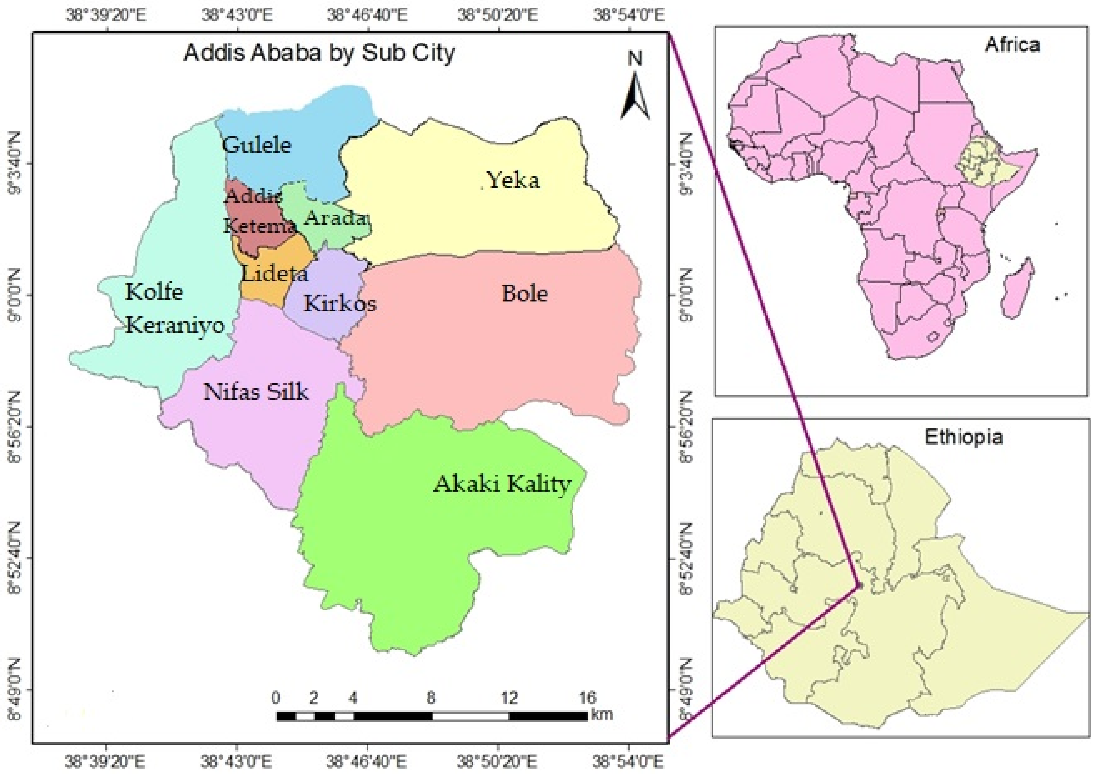
36] revealed that the historic failure of urban cadastral system pilots in Ethiopia in general, and Addis Ababa in particular remains a concern. It is estimated that over 6.5 million parcels are found within the urban jurisdiction of Ethiopia, and out of this, approximately 680,000 parcels are believed to exist in Addis Ababa [
25]. Although a number of cadastral pilot projects were launched in Addis Ababa, there have been many challenges to succeed: - poor cooperation between the two institutions (landholding right provision and cadastral information registration), lack of legal framework to fill the gap between these two institutions, use of different sources of data by the two institutions (the right providing institution uses Arial image Addis Ababa taken in 1996, while the cadastral registration institution uses the Arial image acquired in 2010), the system lacks procedure to eliminate this gap, silence of the law on how the status of parcels placed in the dispute register where there is no response from the right creating institution within 15 days. As a result, most urban people do not enjoy secure land and property rights. This can be evidenced from the report of MoUDC [
27], Chekole et al. [
23], Chekole et al. [
35] and Doing Business Assessment [
19], in which, Ethiopia is ranked at 142th out of 192 countries in the world with respect to cadastral system.
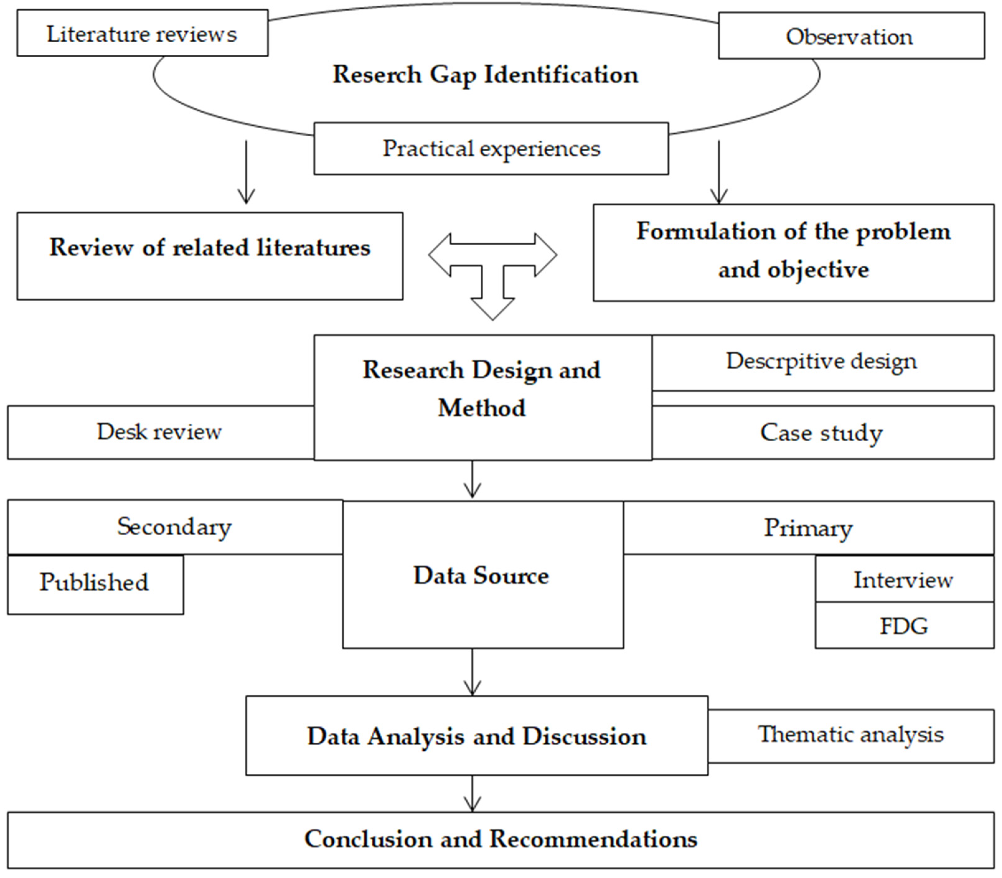
Therefore, the main objective of the research is to analyze the effect of institutional merger between ULDMB and ULARIA on institutional effectiveness. Guided by theory of merger, the paper employs desk review and case study research strategies to uncover the research problem. Within the realm of this thematic scope, the following research question is endorsed: does institutional merger between ULDMB and ULARIA improve institutional performance? By unraveling this question, the paper may contribute an alternative solution that can improve performance of urban cadastral system institutions. Furthermore, quality service delivery may be improved through avoiding bureaucratic processes, and reducing time and cost of services.
The paper is organized in to five sections: introduction: in this section brief information are provided to let readers understand the problem, objective, and scope of the paper. The second section endorsed the theoretical framework to give information on how and with which theory the research is guided. Methodology of the research is presented in the third section, whereas results and discussions, and conclusion are presented in the fourth and the fifth sections respectively.
4. Results and Discussion
Secure, legally enforceable and marketable land rights are critical for cities in developing countries to be able to ensure that urban land is allocated to its most productive use [
17]. The Federal Urban Land & Real Property Registry & Information Agency (FULRPRIA) is an institution established with the Proc. No. 251/2011 [
46], and given responsibility of registering all urban lands in accordance with Proc. No. 818/2014 [
26]. In order to implement this proclamation, cadastral surveying regulation, landholding adjudication and registration regulation, and enforcement guidelines have also been prepared and approved. In addition to these laws, five universities have developed curricula to address the challenges of urban land administration and management. Apart from this, the urban land sector developed 12 occupational standards (OS) to help build the competency of the land administration professionals. In this regard, the sector recruited 4192 professionals from four regions (Tigray, Amhara, Oromiya, and Southern nations) trained and assessed them starting from Level II-IV professions [
25]. All these interventions are made to develop and strengthen the knowledge, skills, and attitudes of land administration professionals, which in turn foster performance of land administration institutions. Despite these efforts and interventions, as stated in the annual report [
27], institutional performance of the cadastral system was not possible to evaluate as successful. In connection with this, the report provides the following challenges for its poor performance; silence of the law about sporadic registration procedure, low emphasis by the right provider for cadastral related activities, delayed responses from the right provider for the cases registered in the dispute registry book, low commitment and engagement by the upper management, and existence of incomplete title evidence for the stated owned lands. Hence all these challenges delayed the smooth implementation of urban cadastral system. In the same manner, these issues have been mentioned in the works of Likinaw [
47], Chekole [
35], Burns [
24], and Daniel [
21] as challenges for the hindrance of successful cadastral system implementation.
The results from the semi-structured interviews, guided by a previously designed questionnaire (see
Table A1), indicate that the achievement of institutional objectives are delayed by varieties of problems, which among others, lack of commitment by the leadership, lack of consistent and organized land information documentation, and lack of proper follow-ups, lack of comprehensive performance evaluation in order to identify its strengths and weaknesses and to propose the redesign strategies, lack of comprehensive review of the cadastral system experiences, lack of adequate study to identify appropriate strategies, poor cooperation between land right providing and registering institutions. According to the directors of ULDMB and ULARIA, despite the importance of follow-ups, leaders’ commitment, institutional collaboration, and proper geospatial documentation to ensure sustainability of the cadastral system, in most cases these components are neglected in the strategic plan. Due to this, they are not performing according to their strategic plans. Since the natures of the two institutions’ operational tasks are interlinked, independent working could not lead them to achieve their targets. Among the challenged stated above, most are directly related to problems associated with poor institutional collaboration. In connection to this, Auzins [
48], asserts that the major source of problem in malfunctioning land administration and management system is miss-arrangement of institutions [
48]. As a result, each institution could not achieve the targeted objectives rather they are repeating the same institutional strategic plans every year. In this regard, a study by Wayumba [
49] indicated that any cadastral system requires a comprehensive evaluation in order to identify its strengths and weaknesses and to propose the redesign strategies. In the same manner, it is possible to consider available resources during the development of strategic plans.
Table 3 presents response rate from both interview and focus group discussions.
In order to verify and validate results of interviews and FGDs, strategic plan (GTP II) and annual performance reports were assessed. According to the strategic plan (GTP II) of Addis Ababa, 430,000 parcels were planned to be adjudicated and registered within 5 years from 2015–2019. However, only 149,584 parcels are adjudicated and registered, which amounts 34.78% performance achievement. This performance level is rated as low based on the scale level indicated in
Table 2.
According to the institutional directors, even if the strategic plan formulated for five years, there is an update every year since the strategic plan by itself is an ambitious, which cannot be realized. It was planned to reach on the target by recording 430,000 parcels within five years. Despite these ambitious plans, the reality on the ground was otherwise. They believe that the main challenges for this to happen are lack of proper consideration of available resources: such as human resource, and money during the planning process; communication gaps among land administration stakeholders; commitment, and poor institutional coordination within the land sector; irregular assignment and replacement of institutional leaders. Hence, they believe these are the major causes for the low institutional performance. Similarly, the Kenyan cadastral system has been hindered by the same challenges mentioned above though they could able to solve the problem through redesigning the overall processes, including strategic plans, and institutional arrangements [
49]. In this regard, studies; Carlos, et al. [
50], and Nicholas [
51] suggest that strategic planning process requires considerable thought and planning on the part of the institution’s upper-level management. Before setting a strategic plan and then determining how to strategically implement it, the upper management of the respective institutions first needs to take into account available resources. In contrast to the cases of Ethiopia and Kenya, the most exemplary experience of Rwanda has laid remarkable story of success across African cadastral system. Across the country, 10.67 parcels have been completed in less than five years with an average of USD7 cost per parcel [
17]. This achievement is attributable to nine years of dedicated reform efforts, which started with a comprehensive review of Rwanda’s policy legal and institutional framework, now regularly updated. Preparations for implementation immediately followed, starting first with piloting to identify scalable approaches for achieving the government’s ambitious targets, with concurrent monitoring and impact evaluation helping to identify problems that could then be discussed by policy makers [
18]. This exceptional experience of Rwanda gave lessons to other countries. In line with this, the findings by Enemark et al. [
52], and UN-GGIM [
7] indicate that the process of formulating strategic plan first needs to assess its current situation by performing an internal and external audit to identify the institution’s strengths and weaknesses, as well as opportunities and threats (SWOT analysis). Based on this analysis, the institutional directors decide on which priority areas they should focus on, how to best allocate the institution’s resources, and whether to take actions such as expanding operations through merger. After setting the strategic plan in this way, it is important for the upper management to evaluate the effectiveness of the strategic plan after the implementation phase [
7]. Strategic plan evaluation involves three crucial activities: reviewing the internal and external factors affecting the implementation of the strategy, measuring performance, and taking corrective steps to make the strategy more effective [
25]. The findings by de Vries et al. [
8] give a good insight in how administrators that encourage and intensify collaboration and integration among public agencies could derive an organizational transformation. In this regard, a framework for effective land administration, FELA [
7], indicates the role of establishing partnerships and collaboration in enhancing effective land administration system. According to this framework, partnerships and collaborations bring different but complementary skills, experiences, knowledge, and resources altogether to improve institutional goals. Likewise, one of the seven underpinning principles of Integrated Geospatial Information Framework (IGIF) is collaboration and cooperation between land administration institutions. In this regard, IGIF [
53] asserts that at the national the level, there needs to be more institutional collaboration and integration across the various land administration institutions. However, in situations where the level of collaboration between related institutions is very weak, according to de Vries et al. [
54] one possible solution is to merge those institutions to effectively provide collective services, based on a single institutional and organizational framework [
8]. From the land management perspective, Yin and Shanley [
55] reveal that operational efficiency is a rational justification for merger. The primary discourse of mergers is rationalist, emphasizing economic gains of increasing efficiency and technical gains of standardization and reduction of redundancy [
54]. In addition, mergers fundamentally change the individual organizations, the responsibilities and accountabilities, the work practices and conventions, the physical location of people and resources, and augment effective authority of the merged organization [
56].
According to the legal framework of the two institutions, they clearly need to cooperate and, even in some way, they need to be integrated. This is mentioned in Art. 14 sub-article of 2 and 3 of Proc. No. 818/2014 [
26], and it reads, in cases where there is inconsistency between the evidences from the empowered right providing institution and the landholder, the issue shall be referred to the right providing institution for verification. In response to this, the right providing institution shall notify its decision relating to the issue raised to the registering institution within fifteen working days. Despite this dictate, survey results show that in most cases, the requested information is not responded within the stated time limit. According to the directors, one of the possible reasons for this to happen is poor coordination between these two institutions. In fact they have a common goal that is securing urban lands in support of sustainable land administration system. However, the reality on the ground seems competing institutions for individual profits. In addition to this, the professionals working in these two institutions are paid differently, regardless of their expertise and experience. This difference came from the fact that ULARIA is established at agency level and supported with project funds. In this case, the professionals working in this institution are paid better than the professionals working in ULDMB. Justified with the weak cooperation and integration, the directors suggested institutional merger between the two institutions and governing with the same legal and institutional framework leads to a better operational performance. According to their perception, providing responsibility to a single institution would be effective than two or more institutions. In this regard, Yin and Shanley [
55] argue that institutional mergers lead to a more effective and transparent processes and to similar services than if only collaboration and integration would increase. This argument is also supported by the works of de Vries et al. [
54], de Vries et al. [
8], Koroso et al. [
4] and Wang et al. [
57] that confirmed single institution can perform operations more efficiently than multiple organizations. Lessons from best experience in land administration show that institutional merger achieves the highest, effective, and sustainable service delivery to the customer. In support of this, countries with merged institutions rank, on average, 38 out of 189 countries in Doing Business [
19]. Countries with separate institutions rank, on average, 47. The report show that merged organizations work better than unmerged organizations [
19].
The other question provided to the directors was concerning the delivery of services in the land administration sector through one window in one place. Among the total 20 interviewees, 80% of the respondents described that the major challenge for the customer is getting land related services in different institutions. For instance, one investor may ask for a plot of land for real estate development. The procedure to obtain this land starts in ULDMB specifically under the directorate for land right creation (provision). This institution creates interests (bundle of rights attached to the land, such as right, responsibility, and restriction. In short, interest in land refers to the right, responsibility, and restriction attached to the landholder). The investor then goes to the ULARIA and request for cadastral surveying and registration of the plot. According to the Proc. No. 818/2014 [
26], it is only when this plot of land is registered by ULARIA said to be legal owner of the parcel. However, these two institutions are physically located in different addresses, which mean the customer has no access for one window service. In this regard, the investor is obliged to visit both institutions to get the service. Although the requested services are interrelated and could be performed by a single institution, the system does not provide one-window service to the customer. This bureaucratic procedure, according to DB [
19], Turisova et al. [
58], and Carlos et al. [
59], creates inconvenience to the customer since it consumes time, energy and cost compared to a single entry point to get the service. Therefore, merging these institutions would provide better services to the customer through one-window service. Jouni [
60] and the World Bank Group [
61] support one-window services in the land administration sector to create simple and smooth processes in executing the tasks of land administration.
In relation to the merits and demerits of institutional merger, institutional directors were asked if institutional merger provides advantages of cost reduction and increase efficiencies. In this regard, the directors (80% of interviewee) strongly believe that merger plays vital role in reducing the costs to be incurred, time to be consumed, and increase efficiencies of the merged institution. On top of this, the resource (e.g., human resource) to be deployed would be used efficiently and wisely. Based on counties experience, for instance Rwanda, the success behind their cadastral system relies mainly on the merged institutional arrangement, which is one of the principles in the cadastral statements. However, Jouni [
60] and the World Bank Group [
61] highlight that no institutional merging can be established overnight, rather it is important to take concrete steps to the right direction of merging. Coherently, the directors of ULDMB and ULARIA in Addis Ababa also believe that urban land right provision and registration activities are closely related fields, and should not be treated nor operated under separate institutions. The targets intended, the resources deployed, the processes involved, and the outcomes provided are more or less the same. The target of urban development and management office is providing landholding right, which needs to be ascertained through cadastral registration. In this case, they believe that land administrators working on the ULDMB can also be deployed in the ULARIA, so that human resources are managed properly. On the basis of these arguments, investigating these two related activities under two different and independent institutions seems an inefficient use of resources.
Finally, regarding the areas for institutional performance improvement to satisfy the needs of their customers, the directors believe that the two institutions first need to be collaborated to execute their planned tasks on the basis of clear guideline that shows their responsibilities and duties through, for instance, signing Memorandum of Understanding (MoU). This mechanism may increase the relation between the two institutions, which in turn positively affect their individual performance. After getting into deep and effective relationships, the cooperation may develop into merging into single institution. However, this does not mean that it can be done in a single stage; rather it should be through some time since the issue needs discussion between the staffs of both institutions. In support of this, de Vries and Miscione [
62] state that in a situation where mergers took place, the root of the transformation is embedded in gradual adaptation and so a merger gradually crystallizes instead of being established by decree. Meanwhile, the two institutions need to put a binding agreement that enforces them to execute the tasks they intended.
Merging cadastral information and land right providing institutions is normally supported from the administrative and legal point of view. The issue of institutional merging is directly linked to cost, time and quality, since time is important to deliver the service, cost determines the amount of money or resources available, and quality represents the fit-to-purpose that the service must be provided. In doing so, the components of merging processes: smooth communication, win-win strategy, achievable plan, common objective, and integration should be placed at the center of the merging process. Unless these elements incorporated and considered during merging process, the envisaged plan may not be achieved. Thus, all these components need to be discussed in front of the staffs who are working at both institutions. This process in turn fosters the initiative to commence the process of merging.
The second type of primary data was collected through focus group discussions (FGD) with experts working in both institutions to understand their perception about the current institutional performance, as well as the possibility to merge the ULDMB and ULARIA. The same questions (refer to
Table A1) were also provided to them, so that their perceptions could be evaluated. All participants of the focus group discussion elaborated the procedures to execute their own tasks, and they all felt challenged by the poor coordination between the two institutions. Ferro and Sorrentino [
63] indicate that institutional strategic partnership between institutions that have related goals is crucial in order to achieve the intended goals. Suitably, all respondents agreed on the basic ideas of merging, and they are trying to emphasize on the need for institutional merger, though they preferred to work gradually. Meanwhile, they emphasized on the use of collaborative mechanisms that can solve their immediate tasks. Accordingly, some kind of arrangements (written and legally binding agreement), which explains the duties and responsibilities between the two institutions may be needed to improve institutional performances. When compared with the insights of the institutional directors, individual staff members of these institutions perceive the merits of institutional merger the same way.
From the result obtained, it can be concluded that all respondents perceive that the cadastral registration institution demands the strong support (e.g., providing landholding related information) from the right providing institution to execute its tasks properly. Apart from this, the landholder must provide his/her holding document evidencing that he is the rightful claimant. It is this document which must be adjudicated with the copy document found in the right providing institution. In this regard, the right providing institution plays major role in providing and confirming that the land holder is the right claimant. This is also supported by the legal framework that dictates about urban land adjudication and registration. In connection with this, the law (Proclamation No. 818/2014) [
26] coerces the right creating institution to provide the requested information within fifteen days. It is the failure to comply with this law that resulted in the poor institutional performance. The findings by, Muparari [
14] asserts that overlaps in organizational functions and processes leads to duplication of data and efforts. Due to this, international research studies; Cadaster 2014 [
13], Sulkowski et al. [
41], Bogaerets et al. [
39], FIG [
60], the World Bank Group [
61], and Peter et al. [
64] advise to consider merging the two as one in order to: reduce the effects of duplication; provide services through one-window; reduce the cost of operations; fill the gaps in communication among the staffs; reduce time of operation; improvement of customer service; increase of efficiency within processes; and provide a more efficient operation of land markets. Accordingly, this study confirms that institutional merger between the two institutions may be a solution to the challenges faced by them.
5. Conclusions and Recommendation
The main research objective of this paper was analyzing the effects of merging cadastral information registration and urban landholding right proving institutions, ULARIA and ULDMB in Ethiopia, respectively. In order to achieve this objective, primary and secondary data sources were used. Primary data were collected through semi-structured interviews and focused group discussion from the case study area, Addis Ababa, whereas secondary data from internet sources, strategic plans, and institutional annual performance reports. Desk review and case study research methods were used with a qualitative analysis approach. Although the findings confirm that many challenging issues such as: poor institutional coordination within the land sector, lack of proper consideration of available institutional resources while planning strategies, communication gaps among land administration stakeholders, irregular assignment and replacement of institutional leaders, and leaders’ commitment are facing, the most challenging one is basically emanates from the poor cooperation between ULARIA and ULDMB, and poorly designed strategic plans. Practically, urban land right provision and registration activities are closely related fields in that the targets intended, the resources deployed, the processes involved, and the outcomes provided are more or less the same. Despite their closeness, these activities are organized and executed by two different and independent institutions. Due to this arrangement, institutional performance could not be successful. Based on the result from both semi-structured interviews and focused group discussion, both ULDMB and ULARIA institutions design strategic plans every year, with low level of achievement or operational performance. This is because of strategic plans are not formulated in consideration with institutional resource capacities.
Therefore, this paper strongly recommends the following two directions in order to improve institutional performance in the urban cadastral system. (1) Strategic plan is a document that guides how specific activities are executed within various hierarchical management levels (upper, middle, lower). Thus, it is imperative to foster communication and interaction among employees and managers at all levels, so as to help the institution to operate as a more functional and effective team. A well-designed strategic plan considers the current situation of the respective institution. In doing so, available resources, money, and time are considered, and priority activities are identified that avoid ambitious plan. (2) Results have shown that the major challenging issue is the poor institutional coordination between ULDMB and ULARIA institutions. For the meantime, these institutions may come to cooperation through signing Memorandum of Understanding (MoU). This arrangement, bounded with clear duties and responsibilities, may reduce their gaps, and increases institutional performances. However, in the long run, we suggest merging these two institutions can: reduce the effects of data duplication; provide services through one-window; reduce the cost of operations; fill the gaps in communication among the staffs; reduce time of operation; improve of customer service; increase efficiency within processes; and provide a more efficient operation of land markets. It should be noted that no institutional merging can be established overnight; rather it is important to take concrete steps to the right direction of merging.
This research focuses on practical application of the theory of merger only in urban land administration processes. Hence, other researchers may conduct a research if the same theory can bring the urban and rural land administration sectors in one umbrella so as to increase efficient operation of land market.


 ,
, 


