
Gradient Difference of Structure of Rural Construction Land in Loess Hilly Region: A Case Study of Yuzhong County, Gansu Province, China


1
College of Geography and Environmental Science, Northwest Normal University, Lanzhou 730000, China
2
Key Laboratory of Resource Environment and Sustainable Development of Oasis, Lanzhou 730000, China
*
Author to whom correspondence should be addressed.
Land 2021, 10(4), 349; https://doi.org/10.3390/land10040349
Submission received: 25 February 2021
/
Revised: 25 March 2021
/
Accepted: 29 March 2021
/
Published: 31 March 2021
Abstract
:Studying the differences in the township gradient of rural construction land structures at the microscale is beneficial for the adjustment of rural construction land structure based on local conditions and differentiation, for the classification and guidance of the scientific planning and management of rural construction land, and for improving the level of intensive use of rural construction land. In this study, we took 268 administrative villages of Yuzhong County in the Loess Hilly Region as the research object and conducted research on the internal structure and gradient difference of rural construction land from two aspects: quantitative structure and spatial layout. The main conclusions are as follows: (1) the distribution of rural construction land has significant connection with the river and road. The land structure of the county is simple, with large differences in area and uneven quantities between different types; (2) the shape of a rural construction land patch is complicated, with a high degree of fragmentation. The spatial agglomeration is not significant, and there is a significant difference between “east-west-north-south” in space; (3) the rural construction land has a significant gradient effect at the township level. In terms of quantitative structure, the closer the construction land is to key towns and central towns, the more complex the construction land, the higher the information entropy as well as the equilibrium degree, and the lower the dominant degree. Moreover, the spatial layout shows an upward trend in the fractal dimension, fragmentation degree and separation degree when the level of the township decreases.
1. Introduction
Rural construction land, also known as rural settlement land [1], includes rural residential land, infrastructure land, public service facility land, industrial development land, transportation land, and other lands within a particular village space. Rural construction land is an integral part of rural land use, and it also demonstrates the core of the rural man–land relationship in providing living places and space for human beings [2,3]. In the context of globalization, urbanization, informatization, and marketization, the world economy is growing at a high speed, and the process of regional integration is accelerating. Rural regions are experiencing social, economic, and cultural transformation in a general way [4,5], which involves various aspects of rural population, land, and industries, for example: the regional differentiation of rural land types, the non-agriculturalization of land types and functions, the upgrading of agricultural, industrial structures, and the transformation of employment and consumption patterns [6,7,8,9,10]. These have resulted in rapid changes in the physical and human landscapes of rural areas, for example: the expansion of a large number of rural residential land base areas, the increase in urban-rural migration, the strengthening of industrial suburbanization, and the significant differences in land use gradients in rural areas [11,12,13,14]. The situation of a single land use type, in the traditional agricultural society where farmers’ livelihoods depended on agricultural production with the rural construction land for residential land due to the low productivity level, has been broken [15].
With the deepening urbanization of the population and land, and the suburbanization of industries, rural construction land is also gradually displaying diversification trends and rustic economic structure, production, and lifestyles [16]. The study of rural construction land would help in understanding the changes of rural land elements in urbanization and suburbanization, and help optimize the rural land use pattern. Earlier European and U.S. scholars conducted a series of studies on the formation, layout, and influencing factors of rural construction land and yielded fruitful results [17]. In recent years, scholars have considered rural construction land as a patch by using the landscape pattern index and analyzed its form, spatial pattern evolution, driving mechanism, its relationship with population and industry, the transformation of rural construction land, and its relationship with other rural land uses [18,19,20,21,22,23,24,25]. Research methods have ranged from qualitative description to quantitative analysis, and the research paradigm of urban land use has been introduced into the study of rural construction land [26,27].
China has been influenced by the ideology of emphasizing the city over rural areas for a long time, and the study of rural construction land has always lagged behind that of urban land. Since the reform and opening-up, rural non-agricultural industries have developed dramatically. Scholars have conducted numerous studies on the formation mechanism, spatial distribution pattern, influencing factors of rural non-agricultural industries, and the relationship between rural non-agricultural industries and agricultural land and industries. Then, several academic achievements of theoretical speculations have emerged. In the new era, rural economic forms, social and cultural functions, and cultural forms are affected by globalization, urbanization, informatization, and marketization. All kinds of commodities and capitals are shifting to rural markets [28,29]. Farmers’ livelihoods are gradually becoming diversified and non-agricultural; rural settlements, residential forms, land resources, and other rural spatial landscapes have shown a tendency to diversify [30]. The types of rural construction land have become more abundant, and the trend of conversion to urban land types is apparent, namely, from a traditional residential-based land type to a “residential-industry-tourism-commercial service” multiple-complex land use model. However, at the same time, there are issues such as the chaotic land structure, the interrelation of various land types, and the extensive use of various construction land, which is inconsistent with the new rural construction and is not conducive to the rural revitalization and the construction of a moderately prosperous society [31]. Different types and scales of rural construction land reconstruction [32], remediation potential analysis [33,34], adaptability evaluation [35,36], spatial layout optimization [37,38], internal space reconstruction [39,40], and “hollowing” [41,42] have gradually become an important part of research of Chinese rural geography. The quantitative in-depth analysis method combining the spatial analysis function of ArcGIS and PRA is used to summarize the natural gradient of rural construction land with the change of topographic factors, the urban–rural gradient of “center-periphery” and the geographical gradient of “Pinghu-Hill-Mountain” [43,44]. However, most of the studies focus on plain regions with relatively good natural resources and economic conditions in terms of the research area. In contrast, few studies are focused on ecologically fragile areas with poor natural conditions, backward socio-economics, and high population pressure. In terms of the research scale, most of the studies are focused on macro and mesoscale research, and the reviews in the micro-village scale are relatively weak. In terms of the research object, the rural construction land is mainly considered a patch or the most basic land use type. It is challenging to meet the requirement of refined management of rural construction land. The landscape pattern index is used to describe its external spatial external shape in terms of research content. Still, the quantitative structure and spatial layout law of rural construction land are not deeply revealed, and it is difficult to uncover the microscopic differences of internal rural land structure and its influence mechanism. In conclusion, the research on the internal structure of rural construction land is relatively insufficient, and it is necessary to deepen further the research on the structure of rural construction land from the micro-scale.
The Loess Hilly and gully region has a fragmented terrain and fragile ecological environment, and is the key and difficult region for rural development and construction in China. This article focused on the rural construction land at the micro-scale, and took Yuzhong County in the Loess Hilly region of Longzhong as a case to study the internal structure and gradient difference of rural construction land from two aspects: quantitative structure and spatial layout. This study can provide theoretical and methodological references for the research of rural transformation and development, and rural revitalization in the Loess Hilly and gully region. In addition, it provides technical support and decision support for the coordination of the man–land relationship in the ecologically fragile region by optimizing the layout of rural construction land, improving the level of intensive use of rural construction land, and promoting the sustainable development of rural economy.
2. Materials and methods
2.1. Study Arear
Yuzhong County is a golden node of “One Belt One Road” and is an important satellite city of Lanzhou, the capital of Gansu Province. It is located between 103°49′15″–104°34′40″ east longitude and 35°34′20″–36°26′30″ north latitude (Figure 1). It is 92 km from north to south, 54 km from east to west, with a total area of 3294.7 km2. Yuzhong County is the intersection of the Loess Plateau and the Qinghai–Tibet Plateau. The terrain is high in the south and low in the north, and the middle part is low-lying and saddle-shaped, with an average elevation of 1480–3670 m. It belongs to a temperate continental climate, with huge climate changes and drought with less rainfall. The annual average temperature is 6.6 ℃, the average annual rainfall is 350 mm, and the annual average evaporation is 1343 mm. In 2019, Yuzhong County had jurisdiction over 11 towns, 9 townships, and 268 administrative villages, with a total registered population of 45.8 × 10⁴, of which the agricultural population was 35.03 × 10⁴, accounting for 76.48% of the total population. The county’s gross national product was 155.71 × 10⁸ yuan, and the ratio of the three industries was 9:47:44. The per capita disposable income of urban and rural residents reached 25,789.39 yuan and 12,000 yuan, respectively.
Combining the “Urban Master Plan of Yuzhong County (2014–2030)” and “Urban-Rural Overall Planning of Yuzhong County (2015–2030)”, the 20 townships of Yuzhong County were classified into three gradients: key towns, central towns and general towns. Key towns include Xiaguanying Town, Heping Town, Dingyuan Town, Chengguan Town. Central towns include Qingcheng Town, Jinya Town, Gongjing Town, Gaoya Town, and Gancaodian Town. General towns include Zhonglianchuan Town, Yuanzicha Township, Xinying Town, Xiaokangying Township, Weiying Township, Shanghuacha Township, Qingshuiyi Township, Mapo Township, Longquan Township, Lianda Town, and Haxian Township. The key towns are centrally distributed in the central Chuan region, the central towns are scattered in the central plains region and the northern mountainous region, and the general towns are distributed in the southern and northern mountainous regions. The township gradient determines the differences in local policies, fiscal economy, and industrial investment, which in turn affect the structure of rural construction land (Table 1).
2.2. Data Sources
This study took 268 administrative villages in Yuzhong County as the evaluation unit, and the adopted data include two parts: basic map data and vector data of the rural construction land of administrative villages. The topographic map of Yuzhong County (1:250,000) and the administrative boundary vector (1:250,000) in the basic map data were from the Gansu Bureau of Surveying and Mapping. The vector map data of rural construction land of administrative villages were from the “the third land survey” database of Yuzhong County in 2019. On the basis of the classification system of land use status (GB/T21010, 2007), and according to scholars’ research on rural residential land [45,46], this article divided the rural construction land of administrative villages into six types: residential land, public service land, infrastructure land, industrial production land, commercial and tourism land, and green land.
2.3. Research Methods
The structure of rural construction land can not only reflect the differences in economic structure and industrial structure among villages, but also characterize the level of township. This paper analyzed the quantitative structure and spatial layout. The quantitative structure is reflected by three indicators: information entropy, equilibrium degree, and dominant degree. The spatial layout is reflected by three indicators: fractal dimension, fragmentation degree and separation degree. Firstly, the required data, such as the area of rural construction land and patches, are counted, then the specific indicators are measured. Finally, the spatial visualization of every indicator is made with the help of the spatial analysis of ArcGIS.
2.3.1. Quantitative Structure Analysis
- (1)
- Information entropy
Information entropy is often used as a quantitative indicator of system information content [47,48]. The quantitative structure of rural construction land can be regarded as the land use type information of the rural construction land, and is identified according to the type information of rural construction land. The calculation formula is:
where Hi is the information entropy of the land use type of i-th rural construction land, and aik is the proportion of the k-th type of land of the i-th village. The smaller the value of Hi, the more monotonous the quantitative structure of the rural construction land. On the other hand, the greater the value of Hi, the more diverse the land use types and the more complex the structure of the rural construction land. Hmin = 0 means that there is only one land use type for the rural construction land in the evaluation unit. If the use type of the rural construction land tends to be at an equilibrium and the area is equal in the village, Hmax = log(n).
- (2)
- Equilibrium degree
The equilibrium degree can better describe the difference in the area of different types of rural construction land. The calculation formula is:
where Ei is the equilibrium degree of the i-th rural construction land, E ∈ [0,1]. The greater the value, the closer it is to the equilibrium. When E=0, the rural construction land structure is in a nonequilibrium state, which means the rural construction land has a single land use type. When E = 1, the rural construction land structure is in an equilibrium state, that is, areas of all types of rural construction land are equal.
- (3)
- Dominant degree
The degree of control of the main types of rural construction land on the entire rural construction land was analyzed through the dominant degree, which is negatively corelated with the equilibrium degree. The calculation formula is:
where Di is the dominant degree of the i-th rural construction land. The value range of the dominant degree is the same as that of the equilibrium degree, reflecting the degree of control of one or more types of land use to the rural construction land.
2.3.2. Spatial Layout Analysis
- (1)
- Fractal dimension
Fractal dimension is an important indicator reflecting the overall characteristics of the land use spatial pattern [49]. It is commonly used to determine the complexity of patch shapes of the land use type. The calculation formula is:
where FD is the fractal dimension, P is the perimeter of the type patch, and A is the area of the type patch. The theoretical range of the fractal dimension is 1.0–2.0; 2.0 means the shape of the type patch is the most complicated.
- (2)
- Fragmentation degree
In landscape ecology, the fragmentation degree indicates how fragmented the landscape is. This article used the number of rural construction land patches per unit area to characterize the fragmentation degree. The calculation formula is:
where C represents the fragmentation degree of the landscape, ∑Ni is the total number of construction land patches, and A is the total area of the rural construction land.
- (3)
- Separation degree
The separation degree reflects the degree of spatial dispersion or agglomeration of different types of patches in the rural construction land in the landscape. The calculation formula is:
where F is the separation degree, S is the total area of rural construction land, Ni is the total number of patches of type i construction land in the rural regions, and Si is the area of construction land of type i. The separation degree of each land type was normalized with the standard deviation, and the normalized separation degree was obtained: . Finally, the separation degree (F) of each village was determined:, where n is the total number of rural construction land types.
3. Result Analysis
3.1. General Characteristics of Rural Construction Land
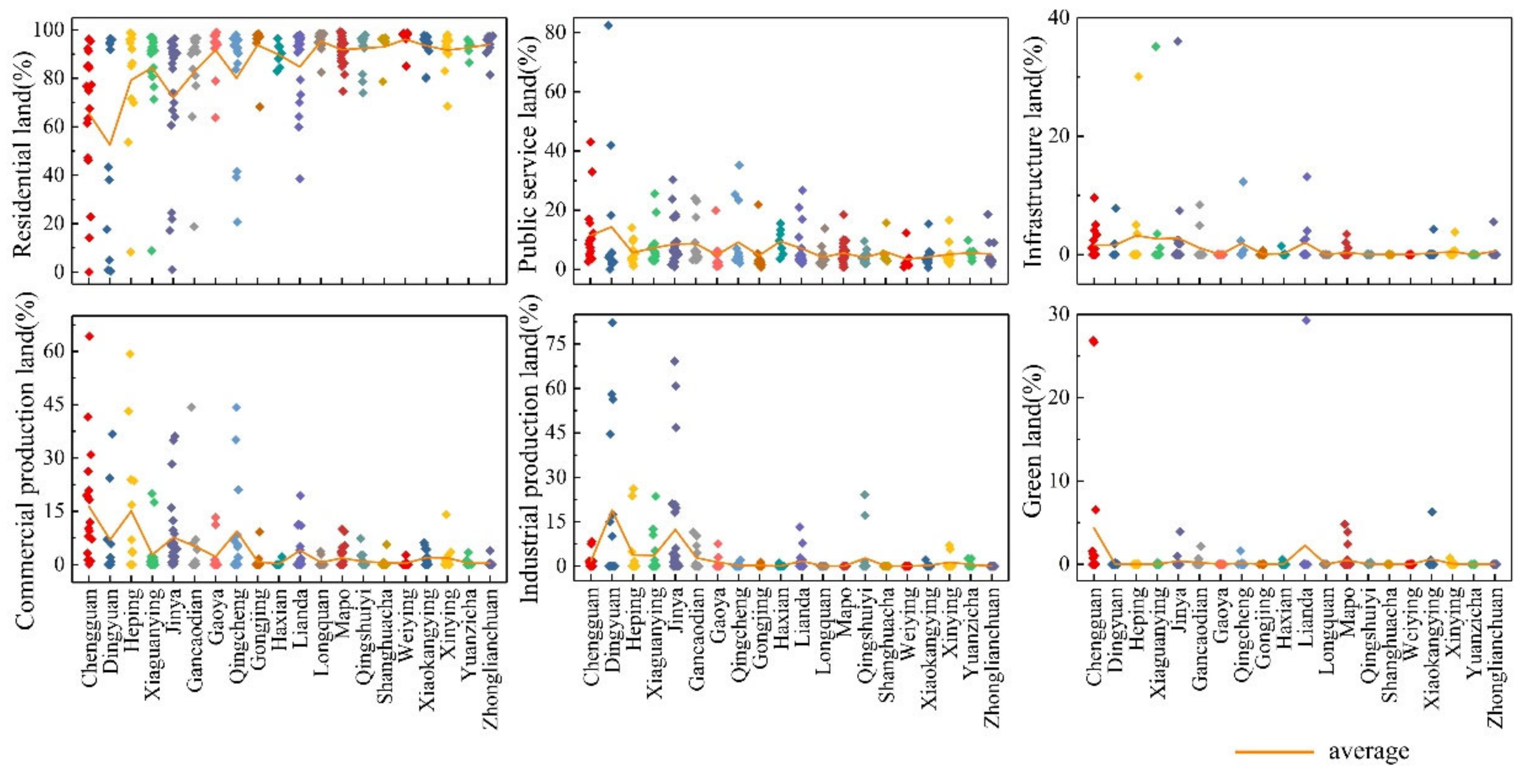
In 2019, the total area of rural construction land in Yuzhong County was 75.92 km2, accounting for 2.31% of the total land area. Among them, the rural homestead area reached 56.26 km2, accounting for 74.12% of the rural construction land, followed by commercial and tourism land; the area of it was 5.73 km2, accounting for 7.6% of the rural construction land. The green land had the smallest area of only 0.68 km2, accounting for less than 0.9% of the rural construction land. From the perspective of the proportion of rural construction land types in 268 administrative villages (Figure 2), residential land was still the main land use type of most administrative villages and accounted for more than 90% of rural construction land in 66.8% administrative villages. Among them, residential land of Datan Village in Mapo Township accounted for as high as 99.3% of rural construction land. The difference in proportion of rural public service land was significant. The least rural public service land accounted for only 0.6% of rural construction land (Hongliangying Village, Xiaokangying Township). The largest rural public service land accounted for 82% of rural construction land (Xiejiazui Village, Dingyuan Town), and the proportion of rural public service land was less than 5% in 58.6% villages. The proportion of infrastructure land was relatively small. 84% villages did not have the infrastructure land. The differences in commercial and tourism land as well as industrial production land were significant, mainly in Chengguan Town, Dingyuan Town, Heping Town, Xiaguanying Town and Jinya Town. Villages in the county without commercial and tourism land and industrial production land accounted for 46.3% and 73.5%, respectively. In recent years, the gradual suburbanization of urban industries and the further enhancement of the ability to drive industrial radiation have profoundly affected the changes in the proportion of various types of rural construction land. In every township, there are obvious differences in the types of rural construction land. The suburban towns, represented by Chengguan Town, are more influenced by urbanization and have diversified lands. Meanwhile, in the northern mountainous townships such as Zhonglianchuan Township, the traditional idea of agricultural cultivation is deeply rooted, and the rural construction land is mainly used for residence, with less land for public services and infrastructures.
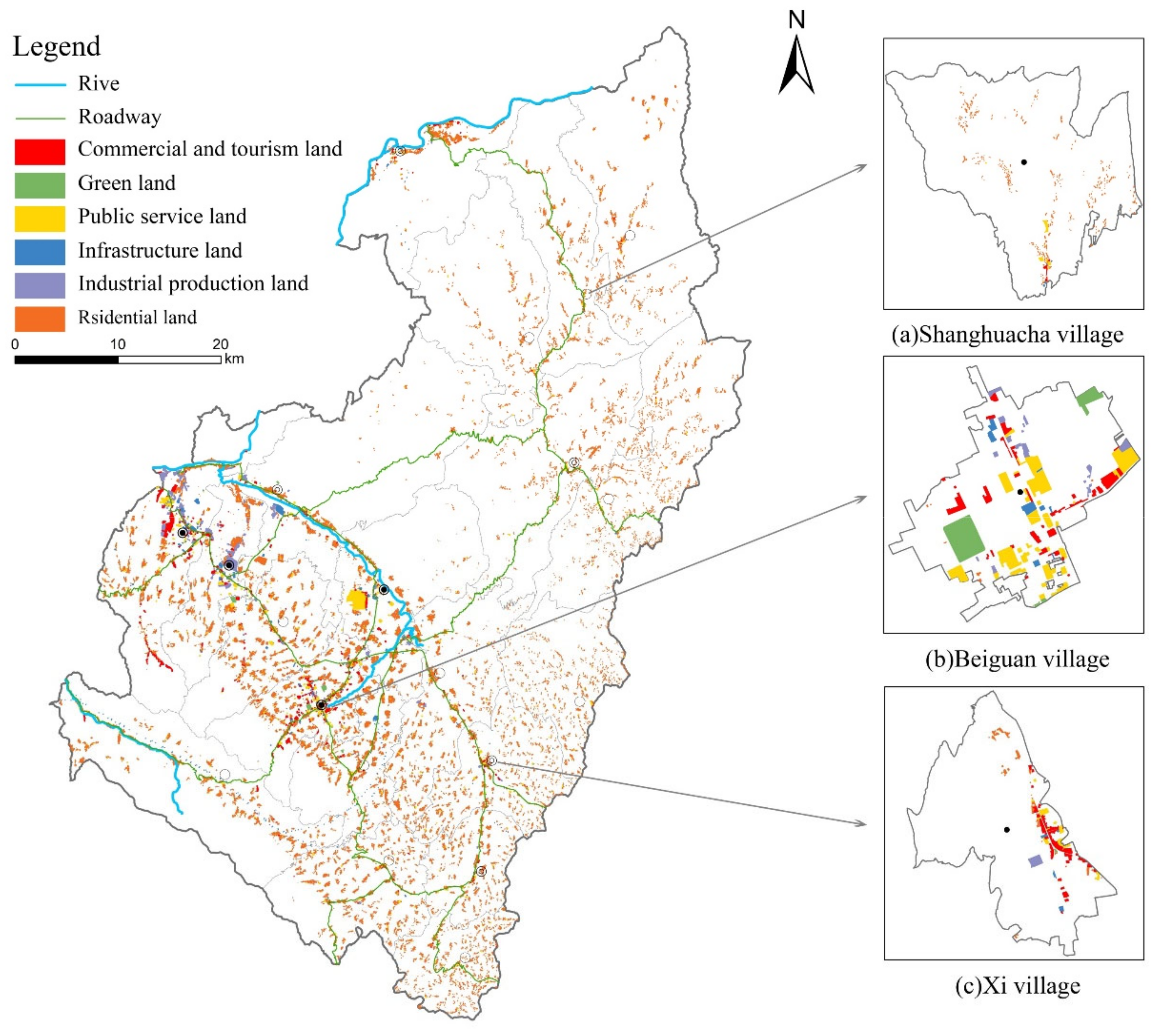
There is a significant difference in spatial distribution of rural construction land among “south-middle-north” regions (Figure 3). The rural construction land in the southern mountainous region is distributed in a strip along the Yellow River. The rural construction land in the central plains region forms an obvious concentrated distribution area along the Wanchuan River valley, the Longhai Railway and the G30 highway. Heping Town, Dingyuan Town, Chengguan Town and Xiaguanying Town present the obvious aggregation nodes. The rural construction land patches are relatively large, the shape and structure are complex, and the types of construction land are more diverse. The rural construction land patches in the northern mountainous region are small and scattered, and the Yellow River crossing QingCheng Town fully confirms that the rural construction land has the characteristic of residing by the water.
Among the 20 townships (towns) in Yuzhong County, Shanghuacha Township, located in the northern mountains, is dominated by traditional agricultural cultivation. The residential land of Shanghuacha Village, where the township government resides, accounts for 78.7% of the rural construction land. Public service land accounts for 15.7% of the rural construction land, and the distribution is relatively concentrated (Figure 3a). Chengguan Town, where the Yuzhong County government resides, is located in the central plains region. It has a good agricultural foundation, and is radiated by the county industry. The rural construction land has changed from residential land use to multiple uses. For example, public service land and commercial and tourism land in Beiguan Village account for 61% of the rural construction land, and the proportion of residential land has been significantly reduced (Figure 3b). Gancaodian Town is the southern gate of Yuzhong County, and many main traffic arteries pass through it. The location advantage brought by traffic has been responded to with land use types. The Gancaodian Town government resident, Xi Village, has multiple land types (Figure 3c), and the commercial and tourism land accounts for 44.3% of the rural construction land.
3.2. Structural Characteristics of Rural Construction Land
3.2.1. Quantitative Structure of Rural Construction Land
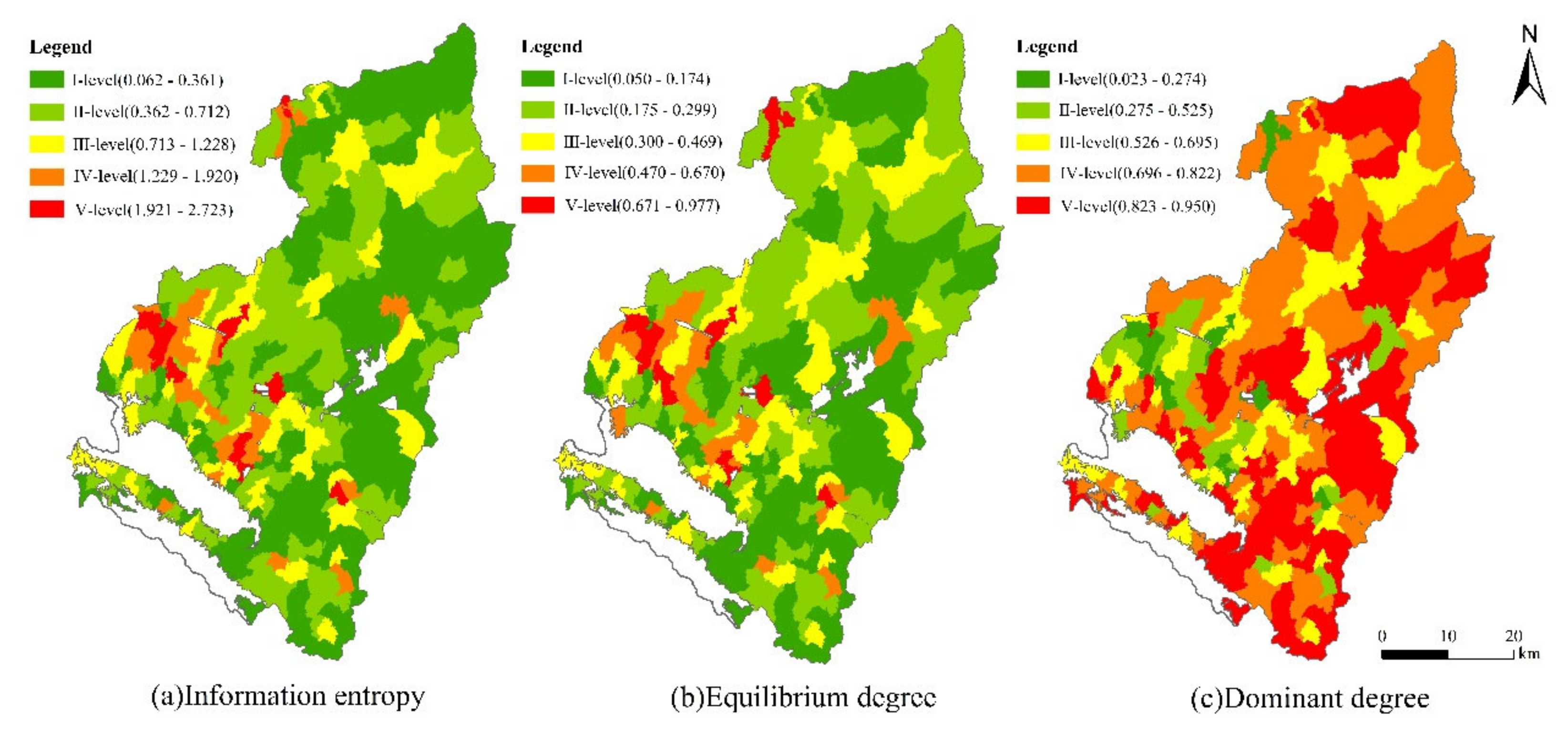
The difference of the rural construction land is firstly reflected in the quantitative structure, which is the basis of an in-depth analysis, and can directly reflect the basic situation of rural construction land structure. Through the natural breakpoint method of ArcGIS, the information entropy, equilibrium degree and dominant degree are classified into five levels, namely I, II, III, IV and V (Figure 4).
As shown in Figure 4a, the information entropy of rural construction land is between 0.062 and 2.723. It is mainly at I-level and II-level, including 103 and 79 villages, respectively. They account for 66.04% of the total administrative villages. There are only 11 villages at Ⅴ-level, which accounts for 4% of the total administrative villages. This indicates that most administrative villages in Yuzhong County have few land-use types and simple land structures. In terms of space, the information entropy of the central plains region is greater than that of both the southern and northern mountainous regions. The types of rural construction land are more diverse, and the land use structure is more complex. The cultivated land in the central plains region has a low slope and high quality, and is close to the main traffic arteries. The transportation cost to the county is low, the accessibility is high, and the economic development capacity is strong. Compared with the southern and northern mountainous regions, the central plains region has the better geographical conditions and development foundation, residential areas with more diversified functions, and more complicated quantity structure of the corresponding construction land.
As shown in Figure 4b, the equilibrium degree of rural construction land is between 0.051 and 0.977. It is mainly in the I-level and II-level, including 94 and 83 villages, respectively. They account for 66% of the total administrative villages. There are only 14 villages at V-level, accounting for 5% of the total administrative villages. This indicates that there is a significant difference in the area of different types of rural construction land, and the internal land use is extremely uneven. The spatial pattern of the equilibrium degree is similar to that of information entropy. The low-value regions are mainly concentrated in the southern and northern mountainous regions of the county, and the high-value regions are relatively close to the county and Lanzhou city. In the high-value regions, industrial production is relatively developed and the popularity of transportation facilities is relatively good.
As shown in Figure 4c, the structural dominant degree of rural construction land is between 0.023 and 0.950, which is relatively high. It is mainly in IV-level and V-level, including 80 and 97 villages, respectively. They account for 66% of the total administrative villages. There are only 13 villages at I-level, accounting for 5% of the total administrative villages. This indicates that the rural construction land of most administrative villages is dominated by a single type. In terms of space, the structural dominant degree of rural construction land in the central plains region is low, and that in the northern and southern mountainous regions is relatively high. The central plains region has relatively good location conditions and a strong urban radiating effect. Diversified economic operations, such as rural tourism, rapidly develop, and the situation of single agricultural production is basically eliminated. The economic structure is diversified, and the per capita disposable income has increased. The requirements for the quality and level of the living environment are improved. The types of land use are relatively diverse, and the dominant degree is low. Contrastingly, in the southern and northern mountainous regions, under the premise that the location and economic conditions are not good, the rural residents mostly rely on the primary industry, with low efficiency and low output. Villagers have conservative thought, and still regard residential land as the main goal of building a closed, safe and comfortable space. The residential land occupies the absolute dominant position in rural construction land.
3.2.2. Spatial Layout of Rural Construction Land
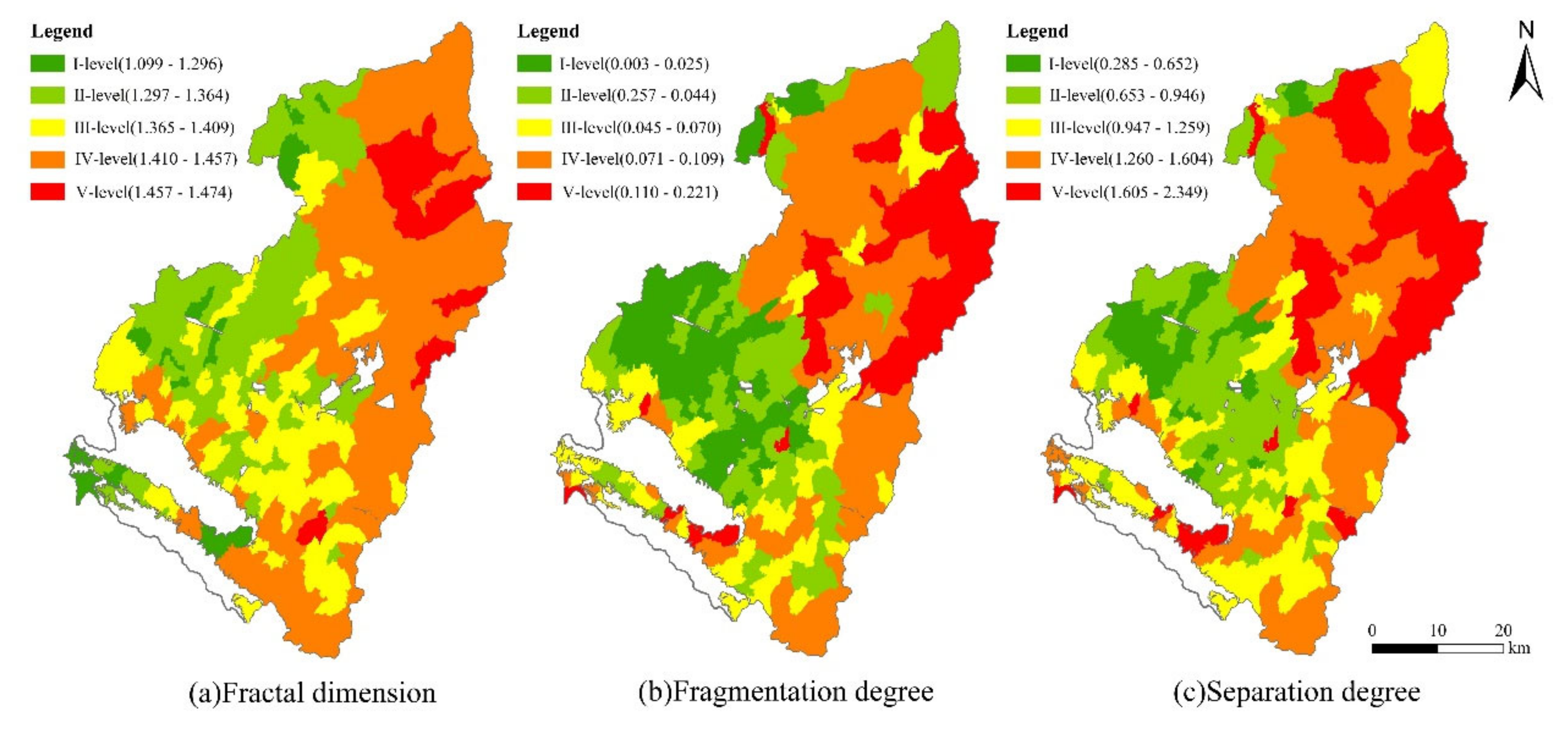
The spatial layout was used to analyze the spatial difference of rural construction land. The natural breakpoint method of ArcGIS was used to classify it into five levels: I, II, III, IV and V (Figure 5).
As shown in Figure 5a, the fractal dimension index of construction land in various rural regions of Yuzhong County is between 1.099 and 1.474. Among them, the number of villages with IV-level is the greatest, reaching 87, followed by those with III-level and those with II-level, which are 80 and 73, respectively. Villages at II-level, III-level, and IV-level account for 89.55% of the total administrative villages, indicating that the patch shape of the rural construction land is relatively complicated. In terms of space, the fractal dimension of Yuzhong County has significant “east-west, north-south” differences. The fractal dimensions of the middle and western regions where Heping Town, Dingyuan Town, and Qingcheng Town are located, and the southern region where Mapo Township is located are significant smaller than that of the northeast region. The middle and southern regions of the county are rich in natural resources, relying on Xinglong Mountain and Maxian Mountain to develop rural tourism and form a spatial agglomeration effect of the rural construction land. In addition, cultural concepts and lifestyles are affected by the city’s “next nearest neighbor effect” and have a strong sense of shared awareness and cooperative spirit. This makes the boundaries of the spatial layout of rural construction land more regular. However, the residential areas in the northeast mountainous regions are scattered across the gully, living spaces are closed, restricted by natural geographical conditions, and the boundaries of the rural construction land are more complicated.
As shown in Figure 5b, the fragmentation degree of the rural construction land in Yuzhong County is relatively low, ranging from 0.003 to 0.221. Villages at V-level have the smallest number of only 28, accounting for 10.45% of the total administrative villages. The number of villages with other four levels are relatively balanced, and are 64, 63, 52 and 61, respectively. In terms of space, the fragmentation degree of the central plains region is significantly lower than that of the southern and northern mountainous regions. The regions with low values are concentrated and contiguously distributed in Heping, Dingyuan, Chengguan and Xiaguanying Town, and the regions with high values are distributed along the northern county boundaries with a striped shape. The central plains region has flat terrain, abundant water resources, convenient transportation, densely distributed rural settlements, a concentrated population, and high land utilization. In addition, under the guidance of the development strategy of “one-heart and two-wing” in the provincial capital Lanzhou City, according to its better location, the central plains region has become the forefront of function overflow of the main urban area of Lanzhou. The undertaking of industrial projects develops mainly in the clustered way. The clusters are closely connected, which increases the connectivity of the rural construction land. The northern mountainous region is vertical and horizontal, and residential areas are scattered. The fragmentation degree is high.
As shown in Figure 5c, the separation degree of the overall patch of the rural construction land is relatively high, ranging from 0.285 to 2.349. The number of administrative villages at II-level, III-level, and IV-level is equivalent, which is 75, 65, and 65, respectively. These account for 76.49% of the total administrative villages. In terms of space, the distribution pattern of separation degree is basically the same as that of the fragmentation degree. The central plains region is dominated by I-level and II-level, forming a small low-value gathering area centered on Heping Town and Dingyuan Town. The central plains region is dominated by secondary and tertiary industries; the land use types tends to be diversified and connected, and the separation degree between patches is low. The southern and northern mountainous regions are dominated by IV-level and V-level, and the residential areas are mostly located on uneven regions in the gully. The living space is relatively closed, and most of the traditional planting industry is the major industry. The spatial connection is weak, and the scattered distribution of patches is obvious.
3.3. Structural Gradient Difference of Rural Construction Land
The above analysis shows that the “south-middle-north” differences in the quantitative structure and spatial layout of rural construction land in Yuzhong County are basically consistent with that of the spatial distribution of township levels. This study used the distance algorithm of ArcGIS to calculate the distance from each administrative village to the different levels of the towns, and explored the gradient relationship between the quantitative structure as well as the spatial layout of the rural construction land and township levels.
3.3.1. Township Gradient Differentiation of the Quantity Structure of Rural Construction Land
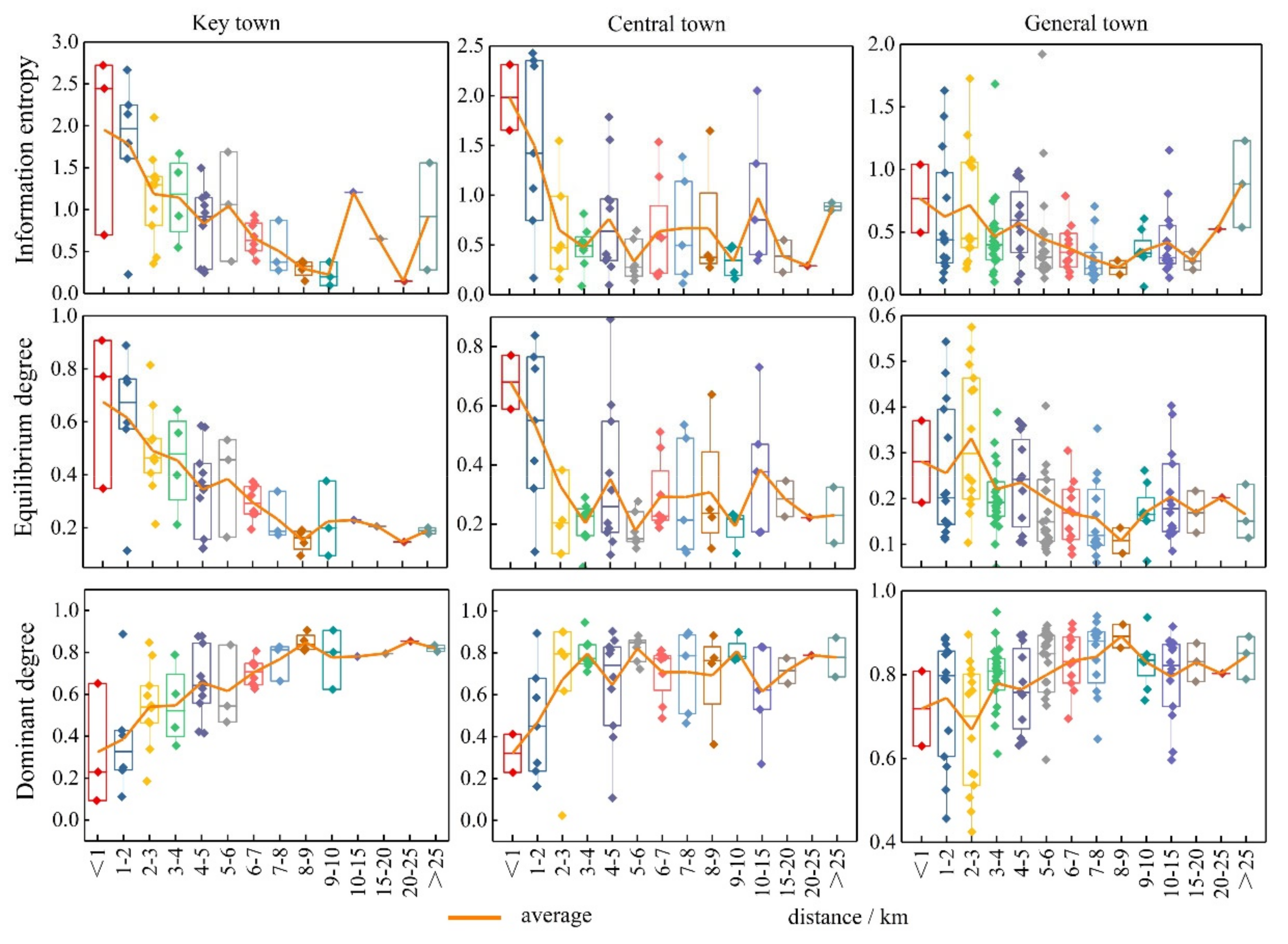
The information entropy of the rural construction land structure varies significantly among the townships with different levels (Figure 6). Specifically, the mean values of key towns, central towns and general towns (townships) are 0.968, 0.737 and 0.484, respectively, which means that the information entropy decreases as the level of townships decreases. Key towns and central towns tend to have different types of construction land due to the high degree of urbanization, population and land. The industries in the villages around the town are gradually transforming into secondary and tertiary industries, and the types of land for construction tend to be diversified. In other words, the higher the township level, the higher the social and economic activity, the greater the impact on villages within a certain range, and the more complicated the affected rural construction land. The average value of the equilibrium degree on the gradient of each township shows a decreasing trend (0.387, 0.32, 0.222). In contrast, the dominant degree value is the opposite, with the average dominance of the general township (0.778) being the largest. The general towns are mostly located in the southern and northern mountainous areas, mostly dominated by traditional farming, and the peripheral villages are less affected by them. Rural residential lands are still the main type, with a relatively low information entropy and equilibrium degree, and a relatively high dominant degree.
Among townships at all levels, the information entropy and equilibrium degree of key towns and central towns decrease significantly with the increase in distance. When the distance from the township is over 10 km, the information entropy and the equilibrium degree start to fluctuate and increase, while the general township shows a fluctuating decreasing trend with the increase in distance. However, the dominant degree tends to increase overall within the townships. The closer the distance between the townships, the more advanced the influence of urbanization. In addition, this effect becomes weaker when distance increases.
3.3.2. The Township Gradient Differentiation of the Spatial Layout of Rural Construction Land
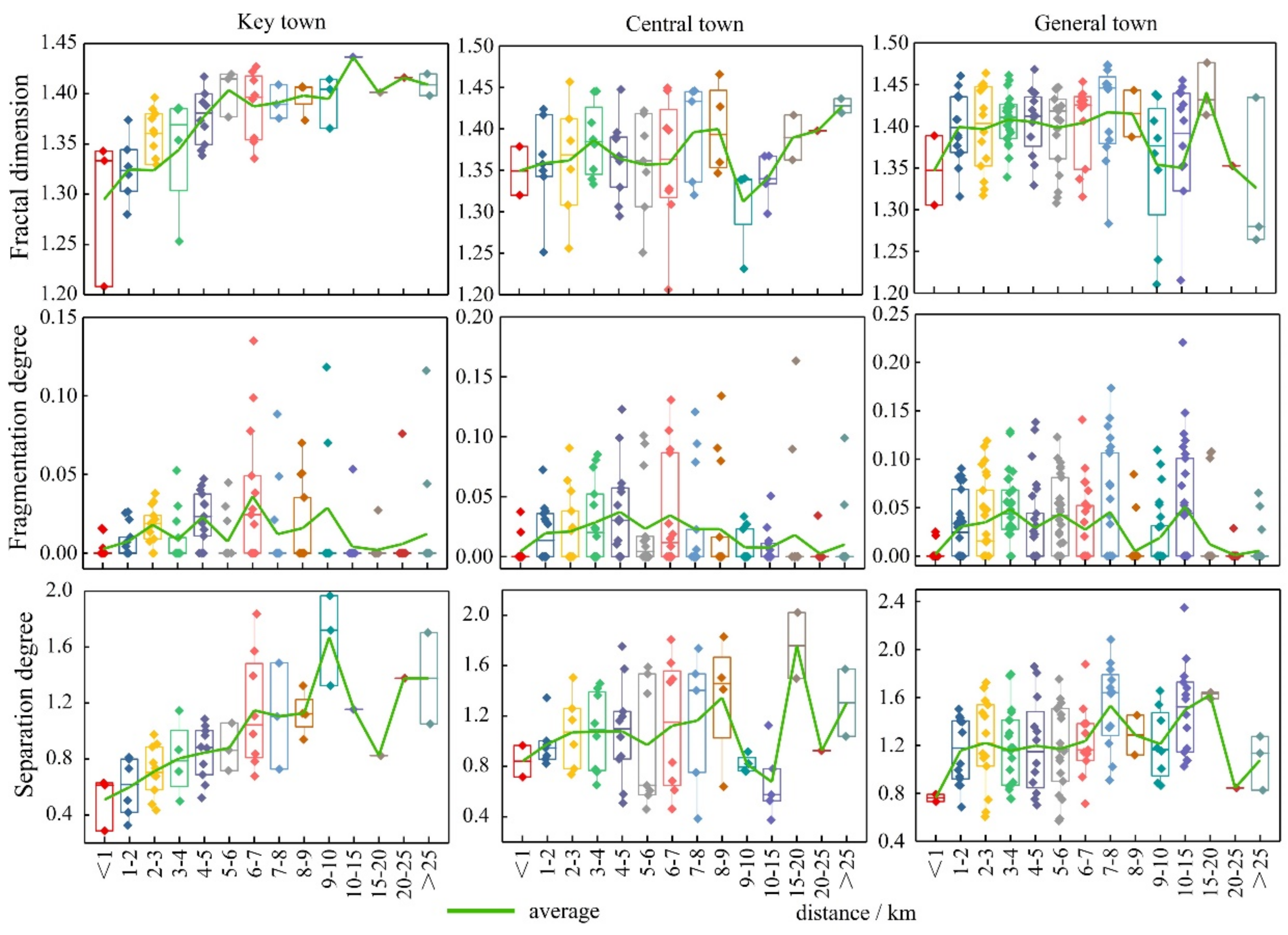
The fractal dimension of “key town-center town-general town” shows a slowly increasing trend (1.364, 1.366, 1.391); the fragmentation degree gradually increases (0.04-0.052-0.067); and the increasing trend of separateness (0.926-1.056-1.248) is obvious (Figure 7). As the level of township develops, the advantages of nature, population and agricultural base as well as policy become more and more obvious. Good infrastructure provides convenience for industries, and industrial clustering makes the land more connected and less fragmented.
The fractal dimensions of key towns within 15 km increase with distance, and those of the rural construction land shows a significant upward trend which tends to stabilize after exceeding 15 km. The fractal dimensions of central towns increase slowly with distance as a whole, and fluctuate more in the range of 9–10 km; the number of dimensions among general towns changes less. The fragmentation degree increases with distance with an “inverted U-shaped” change characteristic. Within 6 km from the key town, the separation degree increases rapidly and fluctuates after the distance is less than 6 km; within the central town and the general town, the degree of separation increases slowly with the distance.
Key towns and general towns have better natural endowment and a socio-economic foundation, which enable them to become the frontier of industrial suburbanization and land urbanization, with higher land concentration, neatly shaped boundaries and less separation between patches. The closer the distance, the more obvious this influence is. In contrast, in general towns, most of the villages are dominated by traditional agricultural cultivation, with scattered settlements and complex land patch shapes.
4. Discussion
The structure of rural construction land is a concrete expression of the interaction between human activities and the natural environment, and is the result of competition and balance in the development process of the countryside [50]. With the development of society and the changing needs of rural residents, the structure of rural construction land has gradually become enriched [51,52]. The quantity, structure and spatial layout in the explicit form of the rural construction land reflect the rural, economic and industrial structure and are associated with major issues of rural land management [53]. Yang and other scholars believe that the structure of rural construction land follows a significant regional differentiation rule [54]. Yuzhong County, with one mountain above and below, and a river in its middle part, has obvious zonal differences in quantitative and spatial structure. With the accelerated urbanization process in Yuzhong County, key towns closer to urban areas have priority access to urban socioeconomic resources, even leading to the deprivation of productive and demographic resources in general towns [55,56]. What is more, influenced by the far-reaching policy on the layout of rural construction land, Heping Town, Dingyuan Town, Chengguan Town and Xiaguanying Town, which are at a high level of economic development, have a complete infrastructure, and an inflow of industrial capital and technical support, which result in an intensive pattern of land use. Land information entropy increases, fragmentation contracts, dispersion degree decreases, and differences on gradients are further enhanced [57]. This paper starts the research from the gradient difference of townships, which is an enrichment of the gradient difference and it may provide some reference for the implementation of rural revitalization as well as the village and township planning in the future.
The difference in the quantitative structure and spatial layout of rural construction land is the comprehensive effect of the natural, economic, social, and cultural environment [58,59]. The effective alleviation of the difference in town gradient of rural construction land structure lies in the efficient circulation of various elements, such as urban and rural economy, society, environment, and information, which promotes the coordination of urban and rural economy, as well as the efficient and reasonable layout of rural resources, and improves the overall development capacity and level of rural regions [60]. Through the analysis of the quantitative structure and spatial layout of rural construction land and the township level gradient, this paper found that the structure of the rural construction land in Yuzhong County is very similar to the spatial distribution pattern of the township level gradient, indicating that the township level gradient is one of the reasons causing the difference in the structure of the rural construction land. The spatial gradient difference of the natural geographical environment, the urban–rural gradient, the axial gradient, and the economic gradient are the main factors affecting rural development, rural transformation, rural differentiation, and rural reconstruction [61]. Following the systematic research perspective of “element→structure→function→effect→control” [62], researchers should further study the process and mechanism of land space differentiation in the process of rural transformation at the village scale, and analyze the spatial differentiation characteristics of the “hybridity” of land use in rural regions, and reveal the differences in the structure of rural construction land from perspectives with different gradients.
This paper was in the context of the rural revitalization strategy, combined with the actual situation of Yuzhong County from the perspective of improving rural living space, production space and ecological space. It was based on regional economic development with the goal of improving the level of rural development, established and improved institutional mechanism and policy system of rural development. Through innovating institutional mechanisms and formulating development strategies in various fields, we solved the construction land security issue in the process of rural development in Yuzhong County and promoted to break the unbalanced economic development based on the township gradient. First, according to the difference in the quantitative structure and spatial layout of the rural construction land, the issue of vacant construction land, especially vacant homesteads, caused by the outflow of labor in the northern Loess Plateau and southern mountainous regions should be evaluated. Researchers provided a guide for the agglomeration of rural industrial enterprises and residents around the city, alleviated the environmental issues caused by industrial enterprises, and reconstructed the relationship between man and land, as well as industry and ecology in the rural regions [63]. In addition, the rural revitalization of Yuzhong County should insist on the development of differentiated industries as the leading factor. Key towns rely on urban radiation to develop urban supporting industries and agricultural service industries. Central towns rely on location advantages to develop rural tourism. General towns develop a special breed based on traditional agricultural planting. Combining the new period, new normal and new phase of development in Yuzhong County, it is necessary to promote the spatial reconstruction of rural construction land and optimize rural production, living and ecological space.
There are many uncertainties and limitations in this study. First, the focus of this study is on rural construction land in Yuzhong County, a specific area in the Loess Hills region. Therefore, these results (quantitative structure and spatial layout) cannot be directly applied to other areas, which is also not the purpose of this study. On the contrary, the quantitative structure and spatial layout analysis methods in this study can be used for the study of the change of land use. Second, the structural analysis of rural land use can be carried out, not only from the quantitative and spatial layout but as the study of functional structure which is also quite important. Last but not least, due to the characteristics of regional heterogeneity, the characteristics of rural land use are jointly influenced by numerous factors; gradient differentiation can also be developed from numerous aspects, which may become the focus of further research.
5. Conclusions
With the rapid economic development, the rural area has undergone great changes. The structure of the economy, society and settlement of rural Yuzhong County are undergoing a comprehensive transformation from traditional to modern, and the proportion of various types of construction land in rural areas varies greatly at different scales.
(1) The proportions of different construction land types in Yuzhong County vary greatly at different scales. At the county scale, the residential land is the main type of rural construction land, and the green land has the smallest proportion. At the township scale, there is a significant difference in the proportion of the internal structure of the construction land among townships. The difference in the spatial distribution among various types of rural construction land is significant. In addition, the rural construction land has obvious river and road directivity in space. In the central plains region, it forms an obvious agglomeration node around the township. In the northern and southern mountainous regions, it is sparsely distributed.
(2) The level of information entropy and equilibrium degree of the quantitative structure of rural construction land in Yuzhong County are relatively low, forming (spatially) the characteristics of differential distribution in the central plains region and equilibrium distribution in the northern and southern mountains regions. The dominant degree and spatial distribution of rural construction land are quite opposites. The fractal dimension, fragmentation degree and separation degree in the spatial distribution of rural construction land are generally high, forming a spatial distribution pattern of “south-north high, middle low”.
(3) The quantitative structure and spatial layout of rural construction land have a significant gradient effect of the township level. In terms of quantitative structure, the closer the construction land is to key towns and central towns, the more complex the construction land, the higher the information entropy and the equilibrium degree, and the lower the dominant degree. This is opposite to the case of general towns. The internal information entropy and equilibrium degree of the township level decrease with the increase in distance, and the dominant degree increases slowly with the increase in distance. As the level of the township decreases, the spatial layout shows an upward trend in the fractal dimension, fragmentation degree and separation degree. Within different township levels, the fractal dimension and separation degree of key towns increase quickly with the increase in distance, and that of central towns and general towns increase gently as the distance increases, showing an “inverted U-shaped” trend.
Author Contributions
Conceptualization, L.M.; data curation, X.C.; formal analysis, L.M.; investigation, Y.Y. and S.L.; methodology, X.C.; project administration, L.M.; resources, L.M.; software, Y.Y. and S.L.; validation, Y.Y. and S.L.; visualization, X.C.; writing, original draft, X.C. All authors have read and agreed to the published version of the manuscript.
Funding
This research was funded by the National Natural Science Foundation of China, grant number 41961033.
Informed Consent Statement
Informed consent was obtained from all subjects involved in the study.
Data Availability Statement
No new data were created or analyzed in this study. Data sharing is not applicable to this article.
Acknowledgments
Authors express great thanks for the financial support from National Natural Science Foundation of China.
Conflicts of Interest
The authors declare no conflict of interest.
References
- Qu, Y.; Jiang, G.; Tian, Y.; Shang, R.; Wei, S.; Li, Y. Urban—Rural construction land Transition (URCLT) in Shandong Province of China: Features measurement and mechanism exploration. Habitat Int. 2019, 86, 101–115. [Google Scholar]
- Liu, Y. Introduction to land use and rural sustainability in China. Land Use Policy 2018, 74, 1–4. [Google Scholar] [CrossRef]
- Afshar, F. Balancing global city with global village. Habitat Int. 1998, 22, 375–387. [Google Scholar] [CrossRef]
- Elshof, H.; Haartsen, T.; van Wissen, L.; Mulder, C. The influence of village attractiveness on flows of movers in a declining rural region. Rural Stud. 2017, 56, 39–52. [Google Scholar] [CrossRef] [Green Version]
- Champion, A.G. Urbanization and counterurbanization. In Applied Geography. Principle and Practice; Psychology Press: London, UK, 1999. [Google Scholar]
- Bai, X.; Shi, P.; Liu, Y. Society: Realizing China’s urban dream. Nature 2014, 509, 158–160. [Google Scholar] [CrossRef] [Green Version]
- Liu, Y.; Yang, R. The spatial characteristics and formation mechanism of the county urbanization in China. Acta Geogr. Sin. 2012, 67, 1101–1110. [Google Scholar]
- Long, H.; Zou, J.; Pykett, J.; Li, Y. Analysis of rural transformation development in China since the turn of the new millennium. Acta Geogr. Sin. 2011, 31, 1094–1105. [Google Scholar] [CrossRef]
- Zhu, F.; Zhang, F.; Ke, X. Rural industrial restructuring in China’s metropolitan suburbs: Evidence from the land use transition of rural enterprises in suburban Beijing. Land Use Policy 2018, 74, 121–129. [Google Scholar] [CrossRef]
- Zhang, L.; Yue, W.; Liu, Y.; Fan, P.; Wei, Y. Suburban industrial land development in transitional China: Spatial restructuring and determinants. Cities 2018, 78, 96–107. [Google Scholar] [CrossRef]
- Song, M.; Wu, Y.; Chen, L. Does the land titling program promote rural housing land transfer in China? Evidence from household surveys in Hubei Province. Land Use Policy 2020, 97, 104701. [Google Scholar] [CrossRef]
- Gao, J.; Jiang, W.; Chen, J.; Liu, Y. Housing-industry symbiosis in rural China: A multi-scalar analysis through the lens of land use. Appl. Geogr. 2020, 124, 102281. [Google Scholar] [CrossRef]
- Gu, H.; Ling, Y.; Shen, T.; Yang, L. How does rural homestead influence the hukou transfer intention of rural-urban migrants in China? Habitat Int. 2020, 105, 102267. [Google Scholar] [CrossRef]
- Long, H.; Liu, Y.; Li, X.; Chen, Y. Building new countryside in China: A geographical perspective. Land Use Policy 2010, 27, 457–470. [Google Scholar] [CrossRef]
- Zhang, B.; Zhang, F.; Zhou, J.; Qu, Y. Functional evolution of rural settlement based on mi-cro-perspective: A case study of Hetaoyuan Village in Yi-shui County, Shandong Province. Sci. Geogr. Sin. 2015, 35, 1272–1279. [Google Scholar]
- Li, Y.; Long, H.; Liu, Y. Spatio-temporal pattern of China’s rural development: A rurality index perspective. J. Rural Stud. 2015, 38, 12–26. [Google Scholar] [CrossRef]
- Jin, Q. The history and current trends of research on rural settlement geography in China. Acta Geogr. Sin. 1988, 43, 311–317. [Google Scholar]
- Song, W.; Li, H. Spatial pattern evolution of rural settlements from 1961 to 2030 in Tongzhou District, China. Land Use Policy 2020, 99, 105044. [Google Scholar] [CrossRef]
- Qu, Y.; Jiang, G.; Ma, W.; Li, Z. How does the rural settlement transition contribute to shaping sustainable rural development? Evidence from Shandong, China. J. Rural Stud. 2021, 82, 279–293. [Google Scholar]
- Yang, R.; Zhang, J.; Xu, Q.; Luo, X. Urban-rural spatial transformation process and influences from the perspective of land use: A case study of the Pearl River Delta Region. Habitat Int. 2020, 104, 102234. [Google Scholar] [CrossRef]
- Lange, A.; Piorr, A.; Siebert, R.; Zasada, I. Spatial differentiation of farm diversification: How rural attractiveness and vicinity to cities determine farm households’ response to the CAP. Land Use Policy 2013, 31, 136–144. [Google Scholar] [CrossRef]
- Holmes, J. Impulses towards a multifunctional transition in rural Australia: Gaps in the research agenda. J. Rural Stud. 2006, 22, 142–160. [Google Scholar] [CrossRef]
- Zhou, T.; Jiang, G.; Li, G.; Qu, Y. Neglected idle rural residential land (IRRL) in metropolitan suburbs: Spatial differentiation and influencing factors. J. Rural Stud. 2020, 78, 163–175. [Google Scholar]
- Long, H.; Li, Y.; Liu, Y.; Woods, M.; Zou, J. Accelerated restructuring in rural China fueled by ‘increasing vs. decreasing balance’ land-use policy for dealing with hol-lowed villages. Land Use Policy 2012, 29, 11–22. [Google Scholar] [CrossRef]
- Ma, W.; Jiang, G.; Zhang, R.; Yuling, L. Achieving rural spatial restructuring in China: A suitable framework to understand how structural transitions in rural residential land differ across peri-urban interface? Land Use Policy 2018, 75, 583–593. [Google Scholar] [CrossRef]
- Liu, Y.; He, S.; Wu, F.; Webster, C. Urban villages under China’s rapid urbanization: Unreg-ulated assets and transitional neighbourhoods. Habitat Int. 2010, 34, 135–144. [Google Scholar] [CrossRef]
- Zhu, F.; Zhang, F.; Li, C.; Zhu, T. Functional transition of the rural settlement: Analysis of land-use differentiation in a transect of Beijing, China. Habitat Int. 2014, 41, 262–271. [Google Scholar] [CrossRef]
- Akira, T. Regional Development Owing to the Commodification of Rural Spaces in Japan. Geogr. Rev. 2010, 82, 103–125. [Google Scholar] [CrossRef] [Green Version]
- Burnley, L. Submergence, Persistence and Identity: Generations of German Origin in the Barossa and Adelaide Hills, South Australia. Aust. Geogr. 2010, 48, 427–439. [Google Scholar] [CrossRef]
- Woods, M. Performing Rurality and Practising Rural Geography. Prog. Hum. Geogr. 2010, 34, 835–846. [Google Scholar] [CrossRef]
- Ma, L.; Tian, Y.; Xie, Z.; Gu, Y. Evaluation of quality and spatial reconstruction of oasis rural settlements based on micro-scale. J. Trans. Chin. Soc. Agric. Eng. 2018, 34, 227–234. [Google Scholar]
- Yang, R.; Chen, Y. Change in key research area and prospect of Chinese rural geography. Prog. Geogr. 2018, 37, 25–40. [Google Scholar]
- Zhang, F.; Zhou, J.; Zhang, B. Construction land consolidation potential analysis for rural settlements from aspects of land use structure and their functions. J. China Agric. Univ. 2016, 21, 155–160. [Google Scholar]
- Liu, Y.; Ren, Y.; Pan, Y.; Tang, X.; Wu, D. Evaluation of rural residential land consolidation potiential: A case study of Wuhua county in Guandong province. Hum. Geogr. 2015, 30, 112–116. [Google Scholar] [CrossRef]
- Tang, Q.; Li, X.; Zhong, B.; Wang, K.Y. GIS-based research on the evaluation of spatial distribution of villages and human settlements environment suitability in Chengkou county of Chongqing. Res. Soil Water Conserv. 2019, 26, 305–311. [Google Scholar]
- Ma, L.; Dou, H.; Xie, Z.; Guo, X. Research on rural settlement reconstruction model based on integrated driving factors and suitability evaluation. Trans. Chin. Soc. Agric. Eng. 2019, 35, 246–255. [Google Scholar]
- Zhao, Q.; Jiang, G.; Ma, W.; Zhou, D.; Qu, Y. Social security or profitability? Understanding multifunction of rural housing land from farmers’ needs: Spatial differentiation and formation mechanism-Based on a survey of 613 typical farmers in Pinggu District. Land Use Policy 2019, 86, 91–103. [Google Scholar]
- Ma, W.; Jiang, G.; Li, W.; Zhou, T.; Zhang, R. Multifunctionality assessment of the land use system in rural residential areas: Confronting land use supply with rural sustainability demand. J. Environ. Manag. 2019, 231, 73–85. [Google Scholar] [CrossRef] [PubMed]
- Tian, Y.; Kong, X.; Liu, Y. Combining weighted daily life circles and land suitability for rural settlement reconstruction. Habitat Int. 2018, 76, 1–9. [Google Scholar] [CrossRef]
- Ma, W.; Jiang, G.; Wang, D.; Li, W.; Guo, H.; Zheng, Q. Rural settlements transition (RST) in a suburban area of metropolis: Internal structure perspectives. Sci. Total Environ. 2018, 615, 672–680. [Google Scholar] [CrossRef] [PubMed]
- Yang, R.; Liu, Y.; Long, H.; Zhang, Y. Research progress and prospect of rural transformation and reconstruction in China:paradigms and main content. Prog. Geogr. 2015, 34, 1019–1030. [Google Scholar]
- Ge, C.; Yuan, X.; Ma, C.; Xu, H.; Ren, Z. Land consolidation potential and spatial restructuring of hollowed village in the loess hilly and gully region. Res. Soil Water Conserv. 2020, 27, 285–292. [Google Scholar]
- He, Y.; Zhou, G.; Tang, K. Land-use spatial gradient and its influence in Yiyang city. Geogr. Res. Aust. 2011, 10, 59–68. [Google Scholar]
- Zang, Y.; Liu, Y.; Yang, Y. Land use pattern change and its topographic gradient effect in the mountainous areas: A case study of Jinggangshan city. J. Nat. Resour. 2019, 34, 1391–1404. [Google Scholar]
- Tian, Y.; Jiang, G.; He, X.; Qu, Y.; Zhou, D. Analysis of internal land use structure differences in rural residential areas in Pinggu District, Beijing. Trans. Chin. Soc. Agric. Eng. 2019, 35, 263–273. [Google Scholar]
- Ma, W.; He, X.; Jiang, G.; Li, Y.; Zhang, R. Land use internal structure classification of rural settlements based on land use function. Trans. Chin. Soc. Agric. Eng. 2018, 34, 269–277. [Google Scholar]
- Shannon, C.E. The mathematical theory of communication. Bell Labs Tech. J. 1950, 3, 31–32. [Google Scholar] [CrossRef] [Green Version]
- Li, J.; Guo, Q. Analysis of dynamic evolvement in urban land-use composition based on Shannon entropy. Resour. Environ. Yangtze Basin 2002, 5, 393–397. [Google Scholar]
- Sun, X.; Su, F.; Lv, T.; Gao, Y. Analysison landscape spatial pattern changes of land use and its driving forces in coastal zone of western Pearl river estuary. J. Geoinf. Sci. 2009, 11, 436–441. [Google Scholar]
- Li, G.; Jiang, C.; Du, J.; Jia, Y.; Bai, J. Spatial differentiation characteristics of internal ecological land structure in rural settlements and its response to natural and socio-economic conditions in the Central Plains, China. Sci. Total Environ. 2020, 709, 135932. [Google Scholar] [CrossRef]
- Emborg, J.; Gamborg, C. A wild controversy: Cooperation and competition among landowners, hunters, and other outdoor recreational land-users in Denmark. Land Use Policy 2016, 59, 197–206. [Google Scholar] [CrossRef]
- Zhang, X.; Wang, H.; Liu, J. Research on the evolution of land use structure of rural settlement in underdeveloped aricultural aresa. Chin. J. Agric. Resour. Reg. Plan. 2020, 41, 195–202. [Google Scholar]
- Marull, J.; Pino, J.; Tello, E.; Cordobilla, M.J. Social metabolism, landscape change and land-use planning in the Barcelona Metropolitan Region. Land Use Policy 2010, 27, 497–510. [Google Scholar] [CrossRef]
- Yang, H.; Yang, Z.; Xin, G.; Li, X.; Cao, R. Multifunction evaluation of rural settlement in the southwest hilly area and its optimizing strategies—A case study in Rongchang district of Chongqing. Chin. J. Agric. Resour. Reg. Plan. 2020, 41, 153–161. [Google Scholar]
- Chen, G.; Zhang, F.; Zhang, B. Change in land use form of rural settlements in the farming-pastoraltransitional zone:a case study in Aluke’rqin Banner, Inner Mongolia. Prog. Geogr. 2015, 34, 1316–1323. [Google Scholar]
- Qu, Y.; Jiang, G.; Zhang, B.; Li, H.; Wei, S. Spatial characteristics of rural residential land transition and its economic gradient differentiation. Acta Geogr. Sin. 2017, 72, 1845–1858. [Google Scholar]
- Zhang, L.; Wang, C.; Du, X.; Wang, Z.; Deng, C.; Li, L. Multifunction compartmentalization of rural settlement land use and its peasant household utilization difference evaluation. Trans. Chin. Soc. Agric. Eng. 2017, 33, 278–285. [Google Scholar]
- Zhang, X.; Han, L. Which Factors Affect Farmers’ Willingness for rural community remediation? A tale of three rural villages in China. Land Use Policy 2018, 74, 195–203. [Google Scholar] [CrossRef]
- Jiang, G.; Zhang, F.; Zhou, D.; Zhao, T.; Xie, Z. Analyzing the Land Use Structure Characteristics of Rural Residential Area in Beijing City. Resour. Sci. 2007, 29, 109–116. [Google Scholar]
- Forde, E.R. Why people move from the rural areas to the urban areas: Some pertinent issues. Popleone 1984, 1, 9–10. [Google Scholar]
- Yang, Y.; Liu, Y.; Li, Y.; Li, J. Measure of urban-rural transformation in Beijing-Tianjin-Hebei region in the new millennium: Population-land-industry perspective. Land Use Policy 2018, 79, 595–608. [Google Scholar] [CrossRef]
- Yang, R.; Luo, X.L. Progress and prospects in rural space diversification, reconstruction, and governance from a development perspective. Trop. Geogr. 2020, 40, 575–588. [Google Scholar] [CrossRef]
- Chernigina, M. Rational evaluation of agricultural suburb land use for residential housing. J. Interexpo GEO Siberia 2019, 7, 297–300. [Google Scholar] [CrossRef]
Figure 1.
Study location map.

Figure 2.
The proportion of various types of rural construction land.

Figure 3.
Distribution map of rural construction land.

Figure 4.
The quantitative structure of the internal land use in the residential area. (a) Information entropy, (b) Equilbrium degree, (c) Dominant degree.
Figure 4.
The quantitative structure of the internal land use in the residential area. (a) Information entropy, (b) Equilbrium degree, (c) Dominant degree.

Figure 5.
The spatial layout of internal land use in the residential area. (a) Fractal dimension, (b) Fragmentation degree, (c) Separation degree.
Figure 5.
The spatial layout of internal land use in the residential area. (a) Fractal dimension, (b) Fragmentation degree, (c) Separation degree.

Figure 6.
Township gradient differentiation of the quantitative structure of rural construction land.
Figure 6.
Township gradient differentiation of the quantitative structure of rural construction land.

Figure 7.
Township gradient differentiation of the spatial layout of rural construction land.


Table 1.
Township gradient.
| Gradient | Total Registered Population (person) | Agricultural Population (person) | Emigrant Population (person) | Per Capita Net Income (yuan) |
|---|---|---|---|---|
| Key town | 102,139 | 72,297 | 24,448 | 8420 |
| Central town | 83,937 | 58,683 | 18,472 | 7374 |
| General town | 941,393 | 87,424 | 44,535 | 6980 |
Publisher’s Note: MDPI stays neutral with regard to jurisdictional claims in published maps and institutional affiliations. |
© 2021 by the authors. Licensee MDPI, Basel, Switzerland. This article is an open access article distributed under the terms and conditions of the Creative Commons Attribution (CC BY) license (https://creativecommons.org/licenses/by/4.0/).
Share and Cite
MDPI and ACS Style
Ma, L.; Cui, X.; Yao, Y.; Liu, S. Gradient Difference of Structure of Rural Construction Land in Loess Hilly Region: A Case Study of Yuzhong County, Gansu Province, China. Land 2021, 10, 349. https://doi.org/10.3390/land10040349
AMA Style
Ma L, Cui X, Yao Y, Liu S. Gradient Difference of Structure of Rural Construction Land in Loess Hilly Region: A Case Study of Yuzhong County, Gansu Province, China. Land. 2021; 10(4):349. https://doi.org/10.3390/land10040349
Chicago/Turabian StyleMa, Libang, Xijuan Cui, Yao Yao, and Shichun Liu. 2021. "Gradient Difference of Structure of Rural Construction Land in Loess Hilly Region: A Case Study of Yuzhong County, Gansu Province, China" Land 10, no. 4: 349. https://doi.org/10.3390/land10040349
Note that from the first issue of 2016, this journal uses article numbers instead of page numbers. See further details here.