


Architecture and Urbanism
Ancient cities are the result of long trajectories of socioecological evolution that can yield insights relevant to modern urban planners, policy makers, and stakeholders (Batty Reference Batty2008; Carballo and Fortenberry Reference Carballo and Fortenberry2015; Marcus and Sabloff Reference Marcus and Sabloff2008; Ortman et al. Reference Ortman, Cabaniss, Sturm and Bettencourt2014; M. E. Smith Reference Smith2007, Reference Smith2011; M. L. Smith Reference Smith2003, Reference Smith2014; Stanley et al. Reference Stanley, Dennehy, Smith, Stark, York, Cowgill, Novic and Ek2016; York et al. Reference York, Smith, Stanley, Stark, Novic, Harlan, Cowgill and Boone2011). The morphological study of architectural features and building arrangement within urban spaces is critical for understanding urbanism as a process (M. L. Smith Reference Smith2003; Steadman Reference Steadman2016). Building types and architectural typologies form the foundational blocks of urban morphology and are essential for identifying architectural patterning (Oliveira Reference Oliveira2016).
Using a process-typological approach (Oliveira et al. Reference Oliveira, Monteiro and Partanen2015), we present an architectural typology from the ancient Purépecha (Tarascan) city of Angamuco, located in the Lake Pátzcuaro Basin, Michoacán, Mexico (Figure 1). Angamuco contains more than 40,000 stone and earthen architectural features (Fisher et al. Reference Fisher, Cohen, Fernandez Diaz and Leisz2017; see Figure 2). The site was occupied before and during the development of the Late Postclassic Purépecha Empire (AD 1350–1530; all dates in this article are AD), which makes it a useful context for evaluating changing urban spatial organization during a period of dramatic sociopolitical fluctuation.

Figure 1. Location of the Lake Pátzcuaro Basin within Mesoamerica. Image from shuttle radar data.

Figure 2. The city of Angamuco within the LPB.
Since 2009, we have used an architectural typology for Angamuco, which is based on a field-verified, intensively mapped sample of more than 7,000 architectural features (roughly 17% of the estimated total number of buildings at the site). These features include building foundations from houses and public structures; storage facilities; monumental architecture such as pyramids, altars, and public buildings; and landscape features such as plazas, roads, terraces, and raised roadways (huatziri). In this article, we discuss the Angamuco typology and how it has helped us gain insights into the development of social complexity and urbanism throughout the course of the Purépecha Empire.
Architecture is the intentional human manipulation of the environment derived from cultural norms, historical contingency, and social memory. The construction of architecture focuses human activities along both functional and sociopolitical realms. Our definition follows a structured approach in which architecture is a material expression of culture that can yield fundamental insights into sociopolitical organization (Bourdieu Reference Bourdieu1977; Giddens Reference Giddens1984). This inclusive definition refers to both buildings and those environmental features that distinguish between mere physical spaces and “places” and those where we engage in social processes (Alejandro Villafanez Reference Villafanez2011; Anschuetz et al. Reference Anschuetz, Wilshusen and Scheick2001; Ashmore Reference Ashmore2002, Reference Ashmore2015; Bradley Reference Bradley2000; Ingold Reference Ingold1993; Joyce and Goman Reference Joyce and Goman2012; Lippard Reference Lippard1997; Walker Reference Walker2012). In this sense, architecture is imbued with social meaning and experiences. For example, it manages the way that the landscape is experienced by creating viewsheds (geographical areas visible from a given location) and by controlling access to certain places based on hierarchy, class, and status (Barrett Reference Barrett1994; Johnson Reference Johnson2012; Tilley Reference Tilley1994).
Buildings and landscape features such as terraces form the urban “tissue” of ancient cities: the arrangement of blocks and streets or the demarcation of space (Scheer Reference Scheer2010:47–48). Architecture is the underlying determinant of the urban tissue, meaning that urban morphology cannot be discerned without a basic knowledge of building forms over time. Thus, an architectural typology—which classifies and defines human-modified features within a landscape—plays a fundamental role in understanding factors involved in the rise, fall, and growth of ancient urban centers.
Angamuco and the Lake Pátzcuaro Basin
In 1519, central and central-western Mexico was dominated by two empires: the Aztecs in the Basin of Mexico and the Purépecha (Tarascans) within the Lake Pátzcuaro Basin (LPB). The LPB contained the capital city of Tzintzuntzan that was the core of a centralized tribute system; it was characterized by a socially stratified population and an engineered environment with widespread terracing and landscape modification (Fisher et al. Reference Fisher, Leisz, Comer and Harrower2013; Pollard Reference Pollard1993, Reference Pollard, Sanders, Mastache and Cobean2003).
In 2007, the Legacies of Resilience: The Lake Pátzcuaro Archaeological Project (LORE-LPB) identified a settlement 5 km east of Tzintzuntzan that was large and undocumented. We named this site Angamuco (Sacapu Angamuco), based on a colonial settlement located in that general region (Beaumont Reference Beaumont1932; Roskamp Reference Roskamp, Jansen and García1997). Angamuco occupies a late Pleistocene lava flow (malpaís) on the eastern boundary of the LPB. Because this landform is not suitable for modern agriculture, thousands of building foundations are well preserved: they include platforms, pyramids, roads, terraces, granaries, and walls manufactured from stacked stone with undisturbed floors, middens, and other deposits.
From 2009 to 2012, LORE-LPB conducted urban mapping to better understand the age, size, number, variation in form, and spatial organization of structures present at Angamuco (Fisher, Bush et al. Reference Fisher, Bush, Cohen and Pezzutti2011; Fisher et al. Reference Fisher, Cohen, Pezzutti and Solinis-Casparius2012). We supplemented this work with lidar scanning covering an area of just over 35 km2 of Angamuco and adjacent areas (Fisher and Leisz Reference Fisher, Leisz, Comer and Harrower2013; Fisher, Leisz, and Outlaw Reference Fisher, Leisz and Outlaw2011; Fisher et al. Reference Fisher, Cohen, Fernandez Diaz and Leisz2017). Following the lidar survey in 2013–2014, we excavated seven locations of the site to better field-verify and understand the lidar data and to provide temporal control (Fisher et al. Reference Fisher, Cohen, Lefebvre, Pezzutti, Solinis-Casparius and Urquhart2013, Reference Fisher, Cohen, Lefebvre, Pezzutti, Solinis-Casparius and Urquhart2016).
Analysis of the complete lidar dataset shows that the entire malpaís landform of 26 km2 is covered with architectural features of varying densities (Fisher et al. Reference Fisher, Cohen, Fernandez Diaz and Leisz2017). The most intensively occupied portions are distinct monumental zones distributed throughout the malpaís. This multinucleated settlement is unusual for Mesoamerica (Mastache et al. Reference Mastache, Cobean, Garcia-Cook and Hirth2008; Sanders et al. Reference Sanders, Mastache and Cobean2003) and potentially for the Purépecha Empire (Pollard Reference Pollard, Sanders, Mastache and Cobean2003). This also means that Angamuco is an example of an urban landscape similar to what has been observed at Cantona and the Malpaís of Zacapu (e.g., Cook and Carrión Reference Cook and Carrión1998; Forest Reference Forest, Gervais-Lambony, Hurlet and Rivoal2017; Millon Reference Millon1973). We have documented more than 60 distinctive, standardized, and recurrent architectural forms throughout the site, including commoner and elite buildings, altars, pyramids, storage facilities, ball courts, and a hierarchical road system. Based on survey data and sampled counting of unsurveyed zones, we estimate that more than 40,000 architectural foundations are present within our suggested boundaries of Angamuco.
Survey, lidar analysis, and excavation demonstrate that Angamuco was occupied from at least the Classic to Contact periods (300–1530), with a primary occupation during the Early to Middle Postclassic periods (900–1350; Cohen Reference Cohen2016). During the Epiclassic and Early Postclassic periods (600–1200), architecture consisted of sunken patio complexes similar to those from the Bajío region of Mexico (Cárdenas-García Reference Cárdenas García1999; Darras and Faugère Reference Darras, Faugère, Williams, Weigand, Mestas and Grove2005; Faugère-Kalfon Reference Faugère-Kalfon1996). Construction expanded during the Middle Postclassic (1200–1350), when the settlement was centered around several nodes with distinct rectilinear pyramid complexes similar to those documented for the nearby Zacapu Basin (Arnauld and Faugère-Kalfon Reference Arnauld, Faugère-Kalfon and Darras1998; Forest Reference Forest2014; Michelet Reference Michelet, Mastache, Cobean, Garcia-Cook and Hirth2008). During the Late Postclassic period, the settlement contracted and focused around at least two nodes with Purépecha imperial-style architecture. The shape of features (circular and square) showed increased variety in architectural form that could relate to the diversification of activities, and their accessibility and location suggested social differentiation. Our preliminary results indicate that, for much of the Postclassic period, Angamuco dominated the eastern portion of the LPB with its large population and territory, extensive built environment, and several civic-ceremonial nodes.
Architecure at Angamuco
An initial version of the architectural typology described here was created in 2007 for a full-coverage survey on the former island of Apúpato (Pezzutti Reference Pezzutti2010). It included a data dictionary with drop-down menus that was then entered into a relational database. The typology was updated and expanded in 2009 for the initial season of mapping/survey at Angamuco and was incrementally modified in subsequent years to reflect the types of features encountered at the site (for early versions, see Ahrens Reference Ahrens2013; Bush Reference Bush2012; Cohen Reference Cohen2016; Fisher, Bush et al. Reference Fisher, Bush, Cohen and Pezzutti2011; Urquhart Reference Urquhart2015). The 2010 version was printed, laminated, and carried in the field by trained archaeologists as a quick reference.
Thousands of ancient buildings and associated landscape features are visible on the surface of Angamuco. The natural surface of the malpaís is irregular and punctuated by ridges, swales, and faults. All of the architecture at Angamuco is composed of stacked, uncut stone that lacks preserved mortar. Foundations are constructed from basalt boulders and slabs removed from the surface or mined from shallow depths within the site. Walls, interior features, and other monumental structures would have been covered with adobe/plaster. It is also likely that some stone structures supported a superstructure of walls made from adobe, wood, or other perishable materials. Mounds, pyramids, and platforms are rubble filled and faced with stacked stone.
Inherent in any typology is the tendency to classify examples that do not conform to existing types; therefore, typologies must leave room for nonconformity. Given the long period of occupation, postdepositional disturbance, and the presence of open-sided structures and walls built from perishable materials, this is especially important for Angamuco. Consequently, we used the concept of the “minimal architectural unit (MAU),” meaning that all architecture at Angamuco that did not conform to a type was classified by the largest component possible. Doing so enabled researchers to document features that did not directly conform to the best-defined types outlined in this section. The complete typology is shown illustrated as flowcharts in Supplemental Figure 1.
Buildings and Landscape Features
In our analysis, we divide the Angamuco architecture into two basic groups: buildings and landscape features. Buildings are embedded in the urban tissue of a city and consist of walls that are often roofed. They are associated with mounds, platforms, or other similar features; serve as the foci for many human activities; and delimit spaces at specific points on the landscape. Buildings can accommodate a limited number of people and a restricted number of activities. In contrast, landscape features are informed by natural features such as topography and water, but they also connect the urban environment. Landscape features tend to delimit larger spaces according to access, ethnicity, class, and function; they include constructions such as plazas, roads, passages, and agricultural areas. Landscape features are both inclusive (e.g., plazas) and exclusive (e.g. private passages) and thus create both open and closed spaces.
Types
Typological systems constitute a fundamental element of classification and analysis that enables the understanding of social variation through time (Adams Reference Adams1988; Dunnell Reference Dunnell1986; Spaulding Reference Spaulding1953). Architectural types form the basic spatial grammar of ancient urbanism and constitute the building blocks of the Angamuco typology. Following Scheer (Reference Scheer2010), we define a type as a class of buildings that follow similar rules of morphology, function, placement within a settlement, and relationships to other buildings. Types are built on abstract conceptions of place and vary around a cultural norm (Johnson Reference Johnson2012; Preucel Reference Preucel2008; Steadman Reference Steadman2016). In this sense, architectural types codify cultural values and embed meaning, and they are not bound simply by function. For example, buildings and spaces enable activities related to the goals of multiple social actors, such as economic activities within domestic spaces (Allison Reference Allison2013; Carballo Reference Carballo2011).
The Angamuco Typology
Our typology is best illustrated as a series of flowcharts (Supplemental Figure 1). Following the MAU principle, a researcher can move through each flowchart using partial or fragmentary features, such as a single wall. The Angamuco typology begins by defining broad categories based on whether a feature is above or below ground (e.g., Ashmore Reference Ashmore and Ashmore1981). An above-ground feature, for example, would typically be located on a building or other feature placed on a platform or mound. In contrast, a ground-level feature, such as a wall, possesses a foundation at ground surface.
Ground-Level Features
Platforms
Platforms are above-ground structures with one level (cuerpo) and a plan that is wider than a single course of stones (Supplemental Figure 1A). Platform cuerpos average around 50 cm in height, although some are taller. The plan for platforms is highly varied, ranging from abstract through compound shapes for buildings to more linear forms for landscape features. Most platforms are generally freestanding and can form the walls of buildings and serve as a base for a structure. In some instances, platforms may be connected to one another to form compound structures. Based on their shape, size, association, and context, we identified four platform types.
The first platform type is characterized as having a square or rectilinear plan. Simple square platforms are composed of a single square feature, whereas double square platforms consist of two features with a division. In double examples, one of the platforms is significantly smaller in size, and the division is often a passage feature resembling a dripline. The function of the second platform remains unknown, although it may be a kitchen or other outbuilding. In contrast, simple square platforms often served as a superstructure for above-ground buildings that ranged from storage or domestic structures to larger public buildings. In many instances, the foundations for Type B and C buildings (see the later discussion) are visible on the top of the platform, along with hearth or oven features (fogónes) and stairs leading to the entrance of the building. Additionally, postholes can be seen on the sides of some platforms. It is possible that some platforms supported freestanding wooden structures like modern trojes, a form of colonial building with a shake roof (Barthelemy and Meyer Reference Barthelemy and Meyer1987; Beals and Carrasco Reference Beals and Carrasco1944:33–36; Beals et al. Reference Beals, Pizana and McCorkle1944; Lumholtz Reference Lumholtz1987:365; West Reference West1948:27–32).
The second platform type is circular and is defined by a lack of corners and sides that are equidistant from a central point. Although the sample of these features is small, we believe that they served as a foundation for both storage features (cuexcomates) and larger circular buildings as illustrated in the Relación de Michoacán (RM; see Ahrens Reference Ahrens2013; Alcalá Reference Alcalá2000). The function of the larger circular buildings remains unknown.
The final two platform types were likely functionally similar to walls (see the later discussion) but are wider than a single or double course of stones with a rubble core. L-shaped platforms have a 90-degree angle, forming a square building with two open sides. One side is longer than the other, and sometimes the shorter side is a square mound with a perishable structure on top. Though none of these features have been excavated, they may represent a small enclosed building (Type B or C). Based on depictions in the RM and excavations at Lagunillas in Michoacán, these features may represent a small enclosed building attached to a porch on which an elite received subjects (e.g., Alcalá Reference Alcalá2000; Robles et al. Reference Robles, Cid Beziez and Méndez2014). Linear platforms are rectangular and may have served the same function as simple walls—demarking roads, groups of buildings, and other landscape features. Others likely delimited larger spaces for defense or for restricting access.
Huatziri
A distinctive type of platform, called huatziri in Purépecha (muro-calzada or road wall), is visible on the outer boundary of complejos and other boundary features at Angamuco (Figure 3). Huatziri are characterized by a single, tall (~2.5 m) level of rubble faced with large stacked stone, a width of 1 m, and a flat top (compacted or paved). They have been documented in other Purépecha cities like Ihuatzio (12 km west of Angamuco) where they were probably used as processional walkways for ceremonial activities (Cárdenas García Reference Cárdenas García1991, Reference Cárdenas García1992, Reference Cárdenas García1993, Reference Cárdenas García2004; Du Solier Reference Du Solier1936; Marquina Reference Marquina1929; Michelet Reference Michelet, Mastache, Cobean, Garcia-Cook and Hirth2008; Rubín de la Borbolla Reference Rubín de la Borbolla1939).
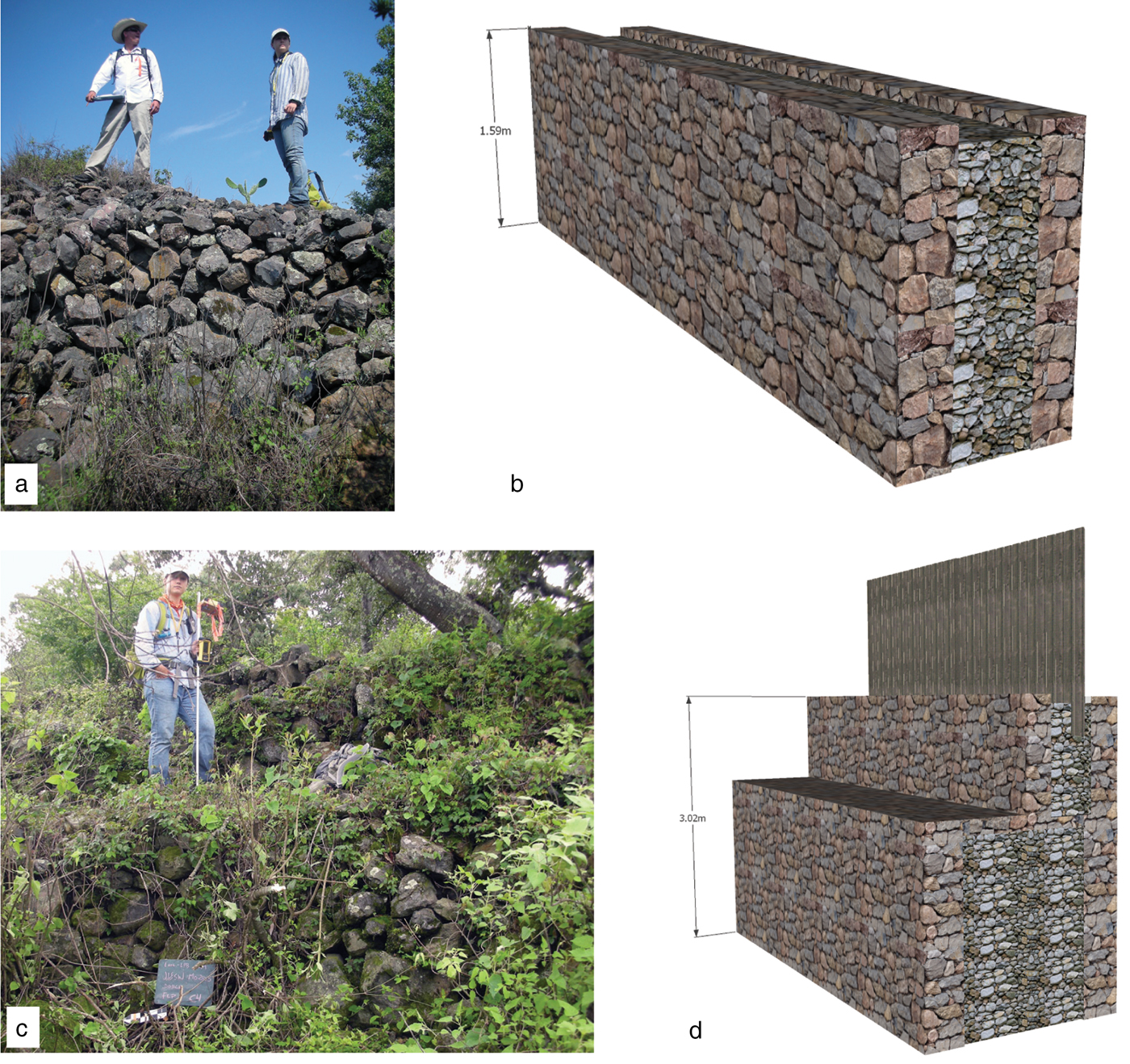
Figure 3. (a) Jason Bush and Andrea Torvinen on top of a huatziri. (b) Reconstruction of the feature based on intensive mapping. (c) Andrea Torvinen standing on the lower course of a huatziri with a bastion or step. (d) Reconstruction of this feature showing how a fence could have been built on the top as mentioned in the RM.
In addition to the basic huatziri type, there are at least two variations in terms of construction, size, and shape. The most common at the site is a much smaller (<1 m height) version that can easily be described as a raised road or causeway (calzada; Bolles and Folan Reference Bolles and Folan2001; Chase and Chase Reference Chase and Chase2001; Denevan Reference Denevan and Trombold1990). Another distinct type contains a second smaller step attached to the main section (Figure 3d). This additional course is smaller and lower in height than the primary cuerpo, is visible on one side only, and runs the full length of the main feature. Some of these examples are located on slopes, so they were likely designed as landscape elements.
Huatziris are not always continuous but sometimes have gaps and open sections along with adjacent portions that lack a connection. Although some of these openings are clearly entrances into compartmentalized sections of the city that lead directly into roads, others are more puzzling. A massive stone wall runs north–south at the Aztec city of Huexotla, and although fragmented, it may be similar to the wall surrounding the Sacred Precinct at Tenochtitlan (M. E. Smith Reference Smith2008:39–41). The intentional breaks underscore the multifunctionality of these features.
Mounds
Mounds are distinguished from platforms by the presence of more than one cuerpo and can be divided into pyramids or altars. Pyramids occur throughout the site and anchor civic-ceremonial nodes or neighborhoods (Fisher and Leisz Reference Fisher, Leisz, Comer and Harrower2013). Different types of pyramids also occur in association within the same neighborhood, reinforcing the notion that these prototypes have unique functional attributes.
Yácata Pyramids
The most distinctive pyramid at Angamuco is a composite shape formed by a conjoined circular and rectilinear element connected at the center by a short linear platform. The result is a stepped pyramid with a keyhole-shaped plan created by combining a circular, linear, and rectilinear mound. The primary axis runs along the central connecting portion, with a secondary axis that follows the long direction of the rectilinear section. Access to the top of the structure is varied and occurs by stairs that cover the stepped portion either on the open face or on the sides of the rectilinear portion. Stairs from the ground surface do not seem to be associated with the circular section. Once on top, access to the circular section is possible either directly from the rectilinear element or along a short connecting platform that runs between the circular and rectilinear elements.
In western Mexico, the semicircular yácata form served as a marker of Purépecha authority (e.g., Acosta Reference Acosta1939; Gali Reference Gali1946; Goggin Reference Goggin1943; León Reference León1886; Lumholtz Reference Lumholtz1987; Pepper Reference Pepper1916; Rubín de la Borbolla Reference Rubín de la Borbolla1941, Reference Rubín de la Borbolla1944; West Reference West1948). At Angamuco, there are at least five clear yácata examples that vary by size, orientation, and morphology. The largest yácata yet documented at Angamuco (MO 5037; Figure 4) was associated with adjacent excavations in 2014 (Cohen Reference Cohen2016:193–215). The circular section has dimensions of 17.5 × 19 m, whereas the rectilinear section is 34 × 13 m. Courses on both sections includes several steps that are 1 m wide and 80 cm tall and that were likely stairways to the top of the pyramid. The overall height of the structure is approximately 6 m tall, although some modern looting has affected this dimension. On the top of the circular portion, we documented the remains of a large room (4 × 6 m) with stone floor remnants. Based on images in the RM, it is possible that a perishable structure with a thatched roof was also located on top of the rectangular portion. Access to the plaza features to the east and northeast of this yácata appear highly restricted, with specific points of entry. Consistent with the material from the adjacent excavation, this pyramid was used during the Middle to Late Postclassic periods (1200–1530), and it has a similar morphology to Purépecha examples at Tzintzuntzan, Ihuatzio, Pátzcuaro, Lagunillas, and San Juan Paragaricutiro (Acosta Reference Acosta1939; Castro-Leal Espino Reference Castro-Leal Espino1986; Lumholtz Reference Lumholtz1987; Robles et al. Reference Robles, Cid Beziez and Méndez2014; Rubín de la Borbolla Reference Rubín de la Borbolla1941).

Figure 4. Yácata pyramid. (a) Plan view of this feature with a 5 cm contour map. (b) Perspective view of this feature using the contour map and a hillshade. Both are derived from 25 cm resolution lidar data. (c) Reconstruction based on intensive mapping.
A potential earlier variant of the traditional yácata form is also present at Angamuco (building MO 2784; Supplemental Figure 3). In this example, the circular and the smaller rectilinear portions are directly joined together. Although postdepositional processes like looting damaged this yácata, four small steps are visible that have similar dimensions to yácata MO 5037 (described earlier). Access to the top of this feature likely came from the open side of the rectilinear portion, although this is unclear. The overall plan of this yácata is similar to Aztec pyramids dedicated to Ehecatl, an avatar of the feathered serpent Quetzalcoatl (Castro-Leal EspinoReference Castro-Leal Espino1986; Pollock Reference Pollock1936; M. E. Smith Reference Smith2008). Elsewhere, circular-based temples or pyramids have been documented at Classic period Teuchitlán sites (the guachimontes structures) in Jalisco and at Preclassic period Cuicuilco in southern Mexico City (discussion in Castro-Leal Espino Reference Castro-Leal Espino1986).
One more potential early yácata variation forms the edge of a sunken patio, with the rectilinear Pyramid 2768 anchoring one end (discussed later). The primary axis runs along the central connecting portion, and a secondary axis follows the long direction of the rectilinear section. This results in three façades for the rectilinear portion and a circular façade at the other end of the primary axis, which would have comprised the main visible portions of the structure, except for the perishable features on the top. The primary functional area of this structure was probably the top of the circular portion, access to which was restricted by a narrow stairway on the rectilinear portion that faced the adjacent sunken plaza.
Rectilinear Pyramids
The most common pyramids at Angamuco are rectilinear forms in which the primary axis is significantly shorter than the secondary axis. Access to this area comes from a stairway that runs along the primary axis that goes over the basal platform.
We have documented more than 20 rectilinear pyramids at Angamuco, and like the yácata form, they occur in a range of sizes and configurations. Some of these examples are associated with sunken plazas with the pyramid anchoring one end, which is similar to Epiclassic (600–900) examples from the Bajío (Cárdenas García Reference Cárdenas García1999; Pomédio et al. Reference Pomédio, Pereira and Fernández-Villanueva2013). The pyramid in Figure 5 is the largest rectilinear pyramid documented at Angamuco: it forms the northeast end of a plaza complex flanked by buildings to the west, south, and east sides, including a proto-yácata to the west. This example has at least four courses and is approximately 15 m high. The remains of a perishable structure, probably room type B (see the later discussion), occupy a small platform on the uppermost level. Access to the top of the pyramid would have been from a stairway along the primary axis on the west face, suggesting that the entrance faced the sunken plaza. Like the Middle Postclassic rectilinear pyramid contexts at the Malpaís of Zacapu and Las Milpillas, this Angamuco example likely served a ritual function associated with religious and funerary activities (Forest Reference Forest2014; Pereira et al. Reference Pereira, Forest, Michelet, Jadot, Barba, Faugère, Elliott and Manin2012; Puaux Reference Puaux1989).

Figure 5. An example of a rectilinear pyramid (central depression is from looting). (a) Plan view of this feature with a 5 cm contour map. (b) Perspective view of this feature using the contour map and a hillshade. Both are derived from lidar data with a 25 cm resolution. (c) Photo of this feature after clearing. (d) Reconstruction based on intensive mapping.
When Acosta and Rubin de la Borbolla excavated Ihuatzio in the 1930s, they documented both rectilinear-based and semicircular yácata pyramids and concluded that the former form relates to an earlier occupation (900–1200), whereas the latter relates to a later Purépecha occupation (1350–1530; Acosta Reference Acosta1939; Pollard Reference Pollard1993; Rubín de la Borbolla Reference Rubín de la Borbolla1941). Although this work occurred before radiometric dating, their interpretation does support the idea that the rectilinear-based pyramids at Angamuco are like the earlier sunken plaza complexes in the Bajío and Tingambato and that the two forms represent different temporal periods.
Altars
The most common type of mound is the altar, a small stepped rectilinear feature found in the centers of plazas and patios, at the entrances or exits of road systems, and in some instances clustered together in groups. Like pyramids, they are composed of more than three cuerpos, but altars are distinguished by their smaller size and the presence of stairways at all sides. There is significant variation in the morphology and placement of these features, and with further research we may be able to identify multiple subtypes of these features.
The altar shown in Figure 6 is a rectilinear stepped mound with four courses and stairways on the west, south, and east sides. We excavated several units around this altar (MO 5001), which is one of two located in an open plaza flanked by yácata MO 5037 discussed earlier. This architectural configuration is similar to that found at Ihuatzio (Acosta Reference Acosta1939), and our excavations indicate use of this feature in funerary activities during the Middle to Late Postclassic periods (1200–1530).
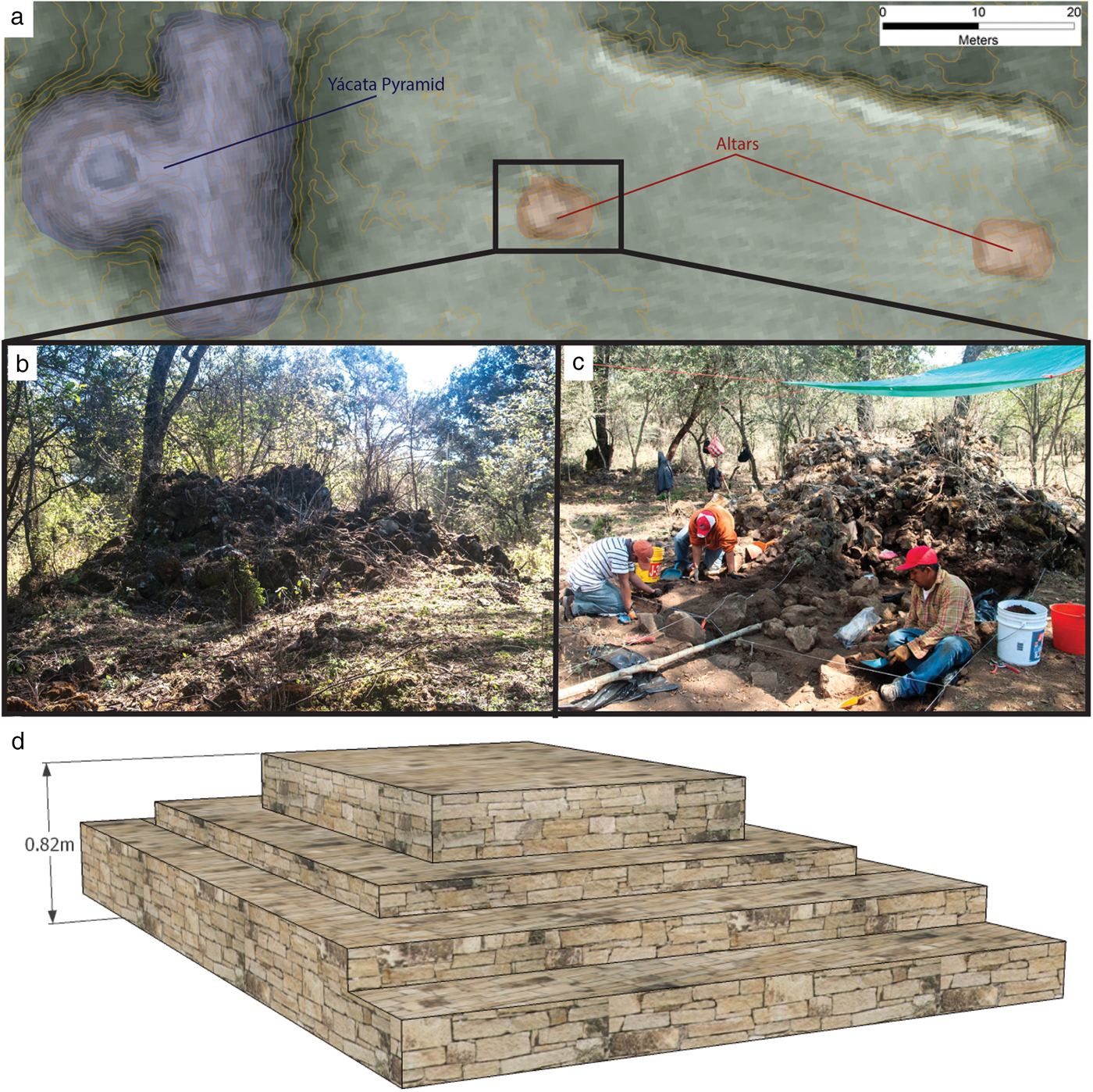
Figure 6. Altar examples. (a) Multiview hillshade with a 25 cm contour map of two large altars within a plaza adjacent to the yácata in Figure 4. All features are derived from 25 cm lidar data; (b) and (c) are photographs of an altar before and during excavation. (d) Reconstruction of an altar from a residential context.
Ground-Level Features
Ground-level architectural features are characterized by square, linear, and circular forms that were the foundations for buildings made from perishable materials such as adobe, wattle and daub, or wooden/cane screens (Supplemental Figure 1b). Ground-level features are distinguished by the number of sides, their shape, and overall configuration.
Walls
The most basic ground-level feature is a wall, composed of a single course of stacked stone that is typically 50 cm wide (although thicker examples do exist) and range in height from 50 cm to 2 m. Four subtypes of walls can be defined by their overall shape and total dimensions:
1. A simple wall is a feature that is less than 10 m long. Simple walls are likely the fragmented remains of buildings or socioeconomic markers such as boundaries. In practice, simple walls longer than 10 m are rare at Angamuco.
2. Like the L-shaped platform, the L-shaped wall consists of two linear sections forming a 90-degree angle. This wall subtype is thinner than the L-shaped platform but probably served the same function as open-sided houses or buildings (see the earlier discussion).
3. A passage or the space created with two parallel walls, typically separated by 50 cm to 1 m.
4. A raised road (causeways and huatziris).
Square-Based Edificios
Ground-level structures with more than two walls are classified as either square-based or circular buildings (edificios). At Angamuco there are four formal types of square buildings based on the number of walls, their configuration, the overall shape of the building, and the presence or absence of a discrete entrance.
Type A has three walls and an open side. The fourth open side was presumably screened by a perishable wall and the entrance to the building. It is commonly small with an interior space that is roughly 1–2 m on a side.
Types B and C have four walls with an open area in one wall that forms an entrance. Type B has a rectilinear plan, whereas Type C is a square and is more common, especially in residential contexts. There are two variations in size and context that may be related to the building's function as a private (single family) or public (priest's quarters). Smaller versions of these types are 1–2 m on the shortest side, with a narrow entrance that averages 50 cm in width. There are larger examples of these features, although they are difficult to interpret because they occupy a wide range of settings and contexts. The size of these larger examples ranges from 4 to 10 m. Buildings located near pyramids and large plazas may have served as priests' quarters as described in the RM. Elsewhere, larger versions of these features are embedded within plazas or elite complexes where they may have functioned as public buildings (Figure 7).
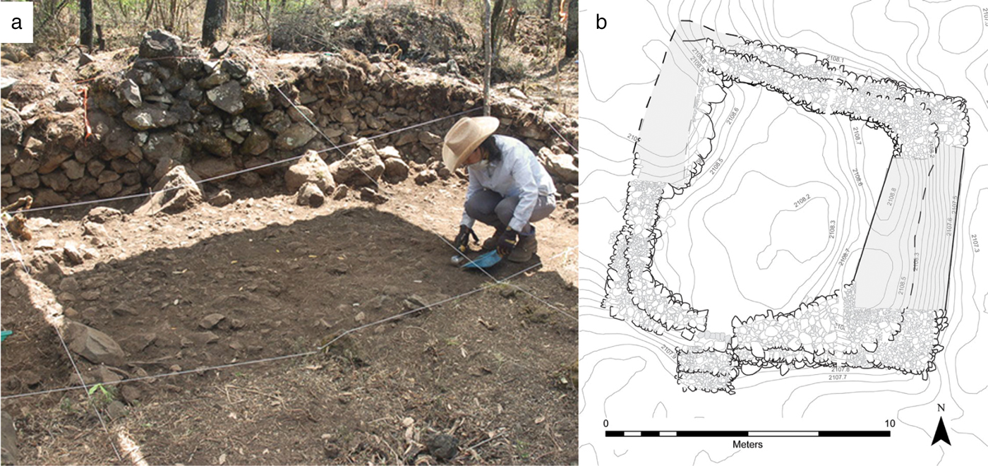
Figure 7. A large type C room, in this instance a public structure excavated in 2013 (Casa 5128). (a) Casa 5128 looking north. (b) Plan map of this same structure (artwork by Karine Lefebvre and Christopher Fisher).
The fourth building type, the room, is a structure composed of four walls without a defined entrance. Rooms that occur singly are often associated with surface material suggesting a domestic occupation. Isolated rooms are rare in the Angamuco sample; more common are clusters of small rooms (1 m on a side) that are associated with large architectural complexes. These room complexes lack overall structural coherency and are difficult to interpret, although they are similar to features documented at Tzintzuntzan and Tingambato (Piña Chan and Oi Reference Piña Chan and Oi1982; Rubín de la Borbolla Reference Rubín de la Borbolla1941; Supplemental Figure 1d).
Circular
A second class of ground-level features is defined by circular foundations. Ahrens (Reference Ahrens2013) examined 296 circular features and identified two major prototypes based on diameter, morphology, and context. The first was likely a granary (cuexcomate), consisting of a circular stone foundation that varies in diameter from <1–3.5 m (mean = 2 m), with a small (25 cm) entrance in one section of the foundation. Some granaries have semi-subterranean interiors with a shallow dished-out bottom, whereas other bases were made from small cobble pavements with an exterior apron. Similar to granaries in the Zacapu Basin (Forest Reference Forest2014:223–234; Michelet and Forest Reference Michelet, Forest, Bortot, Michelet and Darras2012), the superstructure was probably composed of wattle and daube with an upper entrance and a thatch roof. Ahrens (Reference Ahrens2013) also found that granaries with variable diameters occur in public ritual, elite, and commoner contexts and that many are in highly visible locations, such as the edge of a plaza or adjacent to a road. The other likely circular ground-level feature, a possible sweat bath (temezcal), has a stone foundation that is greater than 3.5 m in diameter. Sweat baths are located on a small stepped platform that follows the outline of the overall feature and that includes a narrow step (>30 cm). They are described in the RM as where the king takes baths.
Plazas
In addition to ground-level and above-ground structures, there are features at Angamuco that represent intentional open or negative space (Supplemental Figure 1c; see Bush [Reference Bush2012] for details). The first such feature, the plaza, refers to an intentionally cleared, level, and open space (Inomata and Tsukamoto Reference Inomata and Tsukamoto2014). Open or ground-level plazas are cleared spaces that are usually large in size (>10 m2). They can have surrounding walls of stone and earth and may have adjacent buildings. Open plazas often form connections between neighboring building groups, landforms, and roadways.
In contrast, sunken plazas are rectangular or kidney-bean–shaped open spaces with one to three earthen or stone steps on all four sides. Located generally on higher elevations of the malpaís, sunken plazas vary in size from 250 to 1,000 m2 and may represent an extended household residential group, rather than public space (Bush Reference Bush2012). Wider sections may have been built into the raised roadways, serving as bastions, ramps, or staircases, whereas others may have been used to contain water. A related feature that we classified is the patio, a small (<10 m2) ground-level plaza with paved or packed earth flanked by buildings. Access to these features was restricted and probably served a social group or family.
A final type of prepared open zone is the I-shaped ball court similar to those documented in the Zacapu Basin (Taladoire Reference Taladoire1989; on Ihuatzio, see Cárdenas García Reference Cárdenas García2004). It is likely that other forms are present at Angamuco as well, but the function of these more ambiguous features is harder to interpret. Figure 8 shows the largest of these features at Angamuco. A ballgame using sticks, called pelota tarasca, is still played in parts of Michoacán (Beals and Carrasco Reference Beals and Carrasco1944; Corona Núñez Reference Corona Núñez1957), and today some Purépecha communities participate in a game using a ball on fire.

Figure 8. An I-shaped ball court. (a) Plan view of this feature with a 5 cm contour map. (b) Perspective view of this feature using the contour map and a hillshade. All features are derived from 25 cm resolution lidar data.
Landscape Features
The final major architectural type at Angamuco is the landscape feature, which often appears between the features discussed earlier (Supplemental Figure 1c).
Terraces
We defined three major terrace subtypes. Agricultural terraces are <3 m wide and are located on both steep and gentle slopes. At the Purépecha island treasury site of Apupáto, 1.5 m wide terraces were used for maguey cultivation (Pezzutti Reference Pezzutti2010). West (Reference West1948) reported the use of soil-retaining walls or terraces at the lower edges of hillside fields in Purépecha communities, which are similar to agricultural terraces elsewhere in highland Mesoamerica (Donkin Reference Donkin1979; Parsons and Parsons Reference Parsons and Parsons1990; Rodríguez Reference Rodríguez2006). The second subtype is the habitation terrace, which is distinguished as >3 m in width and is associated with domestic contexts like sunken plazas. These terraces often do not have architectural remains on the surface, although excavations indicate that they functioned as a platform for one or more residences. Finally, the architectural terrace is composed of stone benches or berms typically found in and around large buildings, pyramids, and other structures. These terraces probably supported architectural components or served as stairs leading to the top of features or both.
Units of Movement
Like other cities, at Angamuco there was great concern for space, access, and transport. As mentioned earlier, two additional wall types—passages (pasajes) and huatziri—functioned as access points within and between clusters of buildings, neighborhoods, and other sections of the city. A passage is the fundamental unit of movement in areas of complex architecture and is composed of an interior space formed by walls, platforms, or other adjacent architecture. Passages guided the circulation of people and materials inside complexes of architecture and defined entrances to distinct social places.
The final type of landscape modification are roads (Supplemental Figure 1E), which were visible during survey and in the lidar data. Roads at Angamuco are diverse in their construction style, shape, and extension; they are part of a complex network that links all areas of the site.
Most roads are typically less than 2 m wide and exhibit many of the features that are common among ancient transport networks in the Americas (e.g., Bolles and Folan Reference Bolles and Folan2001; Chase and Chase Reference Chase and Chase2001; Cook and Carrión Reference Cook and Carrión1998; Trombold Reference Trombold and Trombold1991; Snead et al. Reference Snead, Erickson and Andrew Darling2009). The road network of Angamuco is complex: the composition of each road segment, the network itself, and the associated architectural features include access ramps, stairs, curbs, and crossroads. For our initial approach, we established four classes based on length and accessibility to architectural features within the site. Tier 1 roads are generally more than 500 m long and are major thoroughfares connecting districts, traversing the malpaís topography, and highlighting formal entrances to the city. Tier 1 entrance roads are shorter than the other variations. Tier 2 roads are between 100 m to 500 m long and connected internal areas of the settlement, whereas tier 3 roads are less than 100 m long and connected clusters of buildings. Tier 4 roads are the same as passages described earlier, connecting individual buildings or domestic units.
Discussion and Conclusions
Although architectural typologies are fundamental for identifying architectural form and for potential planning purposes and serve as the basis for urban morphology, they are not commonly addressed in archaeology. In this article we presented an architectural typology for the city of Angamuco that represents an important first step toward understanding how ancient Purépecha people adapted to widespread dynamic environmental and sociopolitical conditions, such as those associated with empire formation in Postclassic western Mesoamerica. As a living document, this typology has undergone considerable evolution and modification since it was first introduced in 2007.
Angamuco comprises a dense urban landscape with thousands of architectural foundations that are preserved today. Based on a field-verified sample of more than 7,000 architectural features, the typology outlined here has allowed us to identify, document, and understand architectural patterning at Angamuco. The most common types of structures can be described as living spaces or housing features for both commoners and elites, including small platforms for houses and rectangular and circular walled rooms. The second most common features are structures for public or ritual activities, such as pyramids, plazas, and a ball court. Finally, a small part of our sample are structures associated with agriculture activities such as patios or terraces; however, we expect that additional terraces will be visible in future mapping projects.
The diverse range of structures at Angamuco suggests a large, active, and organized population embedded within an extensive human modified landscape. Based on our architectural sample and chronological information from excavations, the Angamuco urban plan and demographics likely changed throughout the Postclassic period. During the Early to Middle Postclassic periods, residents lived throughout the malpaís in distinctive neighborhoods with plazas and gardens. During the Late Postclassic period, when the Purépecha Empire exerted control in the LPB and throughout western Mexico, some areas of the site were abandoned. These imperial period settlements are represented by the yácatas and monumental architecture discussed earlier. Other former residents may have left Angamuco for imperial cities such as Tzintzuntzan and Ihuatzio. Importantly, the process of population growth during the Early to Middle Postclassic and then abandonment in the Late Postclassic also occurred at the malpaís sites in the Zacapu Basin. At Prieto, scholars argue that the houses and neighborhoods were ritually closed as residents moved to the more cosmopolitan Purépecha sites in the LPB (Migeon Reference Migeon2003). It is possible that a similar process occurred at Angamuco.
Western Mexico is a Mesoamerican core area, and an understanding of Purépecha urbanism is fundamental to broader interpretations of Mesoamerican city planning. This article represents the first architectural typology for the LPB, the heartland of the Purépecha Empire. In the future, Angamuco architecture may be compared to other architectural studies in western Mexico (e.g., Forest Reference Forest2008, Reference Forest2014; Ohnersorgen and Varien Reference Ohnersorgen and Varien1996), which will help us better understand the urban pattern in this relatively understudied part of Mesoamerica. In particular, the Angamuco data can be compared to work in the Zacapu Basin, where residents lived in small (~1 km2) cities on malpaís landforms throughout much of the Postclassic period. Some of the Angamuco architecture is similar to the Zacapu types, such as the circular granaries, ball courts, rectangular-based pyramids, and domestic spaces. In contrast, the Zacapu sites do not have semi-circular yácatas, and few imperial-style artifacts have been recovered (Jadot Reference Jadot2016). This supports the interpretation discussed earlier that these sites were abandoned around the time of empire formation. Other questions relate to how the Angamuco architecture compares with features elsewhere in the pre-imperial territories, such as in the Tierra Caliente and the Sayula and Cuitzeo Basins. With the exception of the Zacapu research, very little work has been done on domestic spaces in Purépecha archaeology, and Angamuco provides an excellent context for evaluating commoner lifeways.
There is a renewed emphasis on comparative approaches to prehistory as archaeologists seek ways to better address cross-cultural problems that have meaning to stakeholders and policy makers (M. E. Smith Reference Smith2011). The increasing use of lidar, computer modeling, and other techniques that are ushering in new preservation methods is facilitating such approaches (Fernandez-Diaz et al. Reference Fernandez-Diaz, Cohen, González and Fisher2018; Llobera Reference Llobera2011). To achieve comparative goals and to analyze big data, archaeologists must new find ways to categorize, quantify, and analyze large and varied types of qualitative and quantitative data. Our field sample is one way to apply computational analysis to a large site using lidar data. Using such datasets, we can understand more about the urban layout of sites that are not always well preserved. Although modern construction and erosion will always be a problem for archaeologists, a bird's-eye urban map can help. We are just scratching the surface of Angamuco research, and this typology forms the foundation for ongoing and future work at the site.
Acknowledgments
This analysis was supported by grants to Chris Fisher from the National Science Foundation (BCS 0818662, BCS 1220016), the National Geographic Society, the NASA Space Archaeology Program, and Colorado State University. We thank the Fontezuelas community, the Tzintzuntzan municipal government, the Tzintzuntzan Community Heritage Council, INAH-Michoacán, and the LORE-LPB field crews between 2009 and 2014 for their help. We appreciate the comments of three anonymous reviewers, which have improved this article.
Data Availability Statement
All data are available upon request from the senior author.
Supplemental Material
To view supplementary material for this article, please visit http://doi.org/10.1017/laq.2019.50
Supplemental Figure 1. Decision tree for the Angamuco architectural typology.


 Open access