
Abstract
The occurrence of coal-bearing strata in a variety of coal-bearing basins of China is characterized by late tectonic deformation and remarkable spatial and geochronologic differences. The main controlling factors, which determine the tectonic framework of coalfields, include the geodynamic environment, tectonic evolution, deep structures, tectonic stress, and lithologic combination of the coal measures. The Chinese continent has experienced multi-stage tectonic movements since the Late Paleozoic. The spatial and temporal heterogeneity of its continental tectonic evolution, the complexity of its basement properties, and its stratigraphic configurations control the tectonic framework of its coalfields’ present complex and orderly patterns. The concept of coal occurrence structural units is proposed in this paper and is defined as the structural zoning of coal occurrence. China’s coalfields are divided into five coal occurrence structural areas, and the structural characteristics of the coalfields in five main coal occurrence areas throughout the country are summarized. Based on the analysis of the relationship between the structure characteristics and occurrence of coal in these coalfields, the coal-controlling structures are divided into six groups: extensional structural styles, compressional structural styles, shearing and rotational structural styles, inverted structural styles, sliding structural styles, and syn-depositional structural styles. In addition, the distribution of coal-controlling structural styles is briefly summarized in this paper.
1 Introduction
China is a complex continent consisting of several stable blocks and active belts. The stable blocks, which have relatively small scales, have a low degree of rigidity and highly deformed sedimentary cap rocks (Ma 1992; Wan 2011; Che et al. 2012). Compared with coalfields developed in a single continent, like North America or Europe, the coal-bearing basins in China have experienced a more complex geological evolution (Wang et al. 2007; Cao 2018). The geology of China’s coalfields is characterized by various types of coal-bearing basins, the later deformation of coal measures, and the complex occurrence of coal.
Tectonic movement is the primary geological factor controlling the formation and deformation of coal, coal seams, coal systems, and coal basins. ① The tectonic depressions formed by crustal movement provide a suitable place for the deposition of coal measures. ② The tectonically uplifted areas provide the material sources for the sedimentary deposition of coal basins. ③ The regional structure in the coal-forming periods determined the distribution of the coal enrichment belt. ④ The structural movement controls the prosperity of coal-forming plants because it affects the paleoclimate and paleogeographic conditions. ⑤ The tectonic-thermal evolution of the coal basins promotes the progress of coalification. ⑥ The folds and faults generated after coal formation destroy the integrity of the coal measures and coal seams by cutting a coalfield into several segments of varying sizes. Thus, the tectonic movements not only affect the direction of coal exploration but also determine the difficulty of exploration and development. Consequently, the study of coalfield structures is a fundamental stage in the evaluation and exploration of coal resources (Cao et al. 1999, 2013; Cheng et al. 2010).
2 Basic features of Chinese coalfield structures
Since the Late Paleozoic, the Chinese continent has successively experienced the Paleo-Asia geodynamic system (Ren et al. 1990), the Pacific geodynamic system, and the Tethys geodynamic system. The spatial and temporal heterogeneity of its continental tectonic evolution, the complexity of its basement properties, and its stratigraphic configuration determine the tectonic framework of the coalfields’ present complex and orderly patterns. The regional tectonic factors that control the framework of Chinese coalfield structures include a first-level belt (the north–south trending Helan–Taihang–Ailao mountains structural belt) and three second-level belts (the Altay–Yin mountains structural belt, the Kunlun–Qinling–Dabie mountains structural belt, and the Greater Khingan–Taihang–Wuling mountains structural belt). Similar to the structure of the Chinese continental lithosphere (Li 2006), the tectonic framework of Chinese coalfields can be divided into two major coalfield tectonic regions, three coal measure deformation zones, and five coal occurrence areas (Fig. 1).

Tectonic framework of coalfields in China. 1–Carboniferous–Permian coal measure; 2–Upper Triassic coal measure; 3–Early-Middle Jurassic coal measure; 4–Lower Cretaceous coal measure; 5–Paleogene–Neogene coal measure; 6–first-level structural boundary; 7–second-level structural boundary; I: Eastern compound deformation zone; II: Western compressional deformation zone; III: Middle transitional deformation zone; NECCA: North East China coal occurrence area; NCCA: North China coal occurrence area; NWCCA: Northwest China coal occurrence Area; SCCA: South China coal occurrence area; YXCA: Yunnan–Tibet (Xizang) China coal occurrence area
2.1 Two major coalfield tectonic regions
The Chinese continent is divided into the eastern coalfield tectonic region and the western coalfield tectonic region by the north–south trending Helan–Longmen Mountains structural belt.
-
(1)
The eastern coalfield tectonic region includes two deformation zones, the eastern compound deformation zone and the middle transitional deformation zone, and three structural areas, the Northeast, North, and South coal occurrence structural areas. This region is characterized by multiple coal-bearing strata, a diversity of coal-bearing basins, the complicated evolution of its coal-bearing basins, the complicated deformation of its coal measures, and remarkable spatial and temporal differences. The basic distribution framework of the coalfield structures has an NE–NNE trend.
-
(2)
The western coalfield tectonic region has a scope similar to that of the western compressional deformation zone, and it includes the northwest coal occurrence structural area and the Yunnan–Tibet coal occurrence structural area. The Early-Middle Jurassic coal measures are distinctly superior in these areas, with inland lakes as the main coal accumulating environment. The formation and deformation of the coal-bearing basins were controlled by the Tethys geodynamic system, and the basins exhibit evidence of conspicuous structural inversion during the Cenozoic. Taking compressional structures as the main structural styles, the coalfield structures are NW–WNW trending.
2.2 Three structural assemblage zones of the deformation of coal measures
-
(1)
Eastern compound deformation zone. The later deformation of the coal measures was significant and diverse east of the Greater Khingan–Taihang–Wuling Mountains. Deformation mainly took place in compressional environments south of the Qinling–Dabie Mountains and in extensional environments in Northern China and Northeastern China. The basic framework of the structural assemblage of the deformation of the coal measures is characterized by parallel NE–NNE trending structures, and the extent and intensity of the deformation decreasing from east to west.
-
(2)
Western compressional deformation zone. The structural framework of the coalfields west of the Helan–Longmen Mountains is characterized by compression. The distribution of the coalfield structures exhibits an NW–WNW–NNW arc shape, and the intensity of the deformation decreases northward. The structural assemblage of the deformation of the coal measures transitions from a parallel banding pattern in the Yunnan–Tibet coal occurrence structural area to a multicenter annular pattern in the northwest coal occurrence structural area.
-
(3)
Middle transitional deformation zone. This is a transitional zone between the Helan–Longmen Mountains structural belt and the Greater Khingan–Taihang–Wuling Mountains structural belt. The structure of the crust is stable, and the evolution of the coal-bearing basins shows its tectonic heritage. The structural assemblages of the deformation of the coal measures in the Ordos Basin and the Sichuan Basin exhibit a typical Platform concentric annular structure.
2.3 Five coal occurrence structural areas
Two east–west trending first-level structural belts, the Yinshan–Yanshan orogenic belt and the Kunlun–Qinlin orogenic belt, together with a north–south trending first-level structural belt divide the continent into five main coal occurrence structural areas. These areas are the Northeast China coal occurrence structural area, the North China coal occurrence structural area, the Northwest China coal occurrence structural area, the South China coal occurrence structural area, and the Yunnan–Tibet coal occurrence structural area. These structural belts and structural areas form the basic architecture and structural framework of the coal fields in China.
3 Division of the coal occurrence structural units
3.1 Concept of coal occurrence structural unit
The distribution of coal measures and coal seams is characterized by zoning and banding and is largely controlled by the present-day regional tectonic framework. A coal occurrence structural unit is an important concept that has been proposed by previous studies of coalfield structures throughout the country, which is part of the work of the National Potential Evaluation of Coal Resources (Cao et al. 2013, 2016; Cheng et al. 2016). According to the requirement for the evaluation and exploration of coal resources, it is used to describe the regional tectonic framework and tectonic evaluation control of the occurrence of coal measures, and it highlights the current occurrence status of coal measures that have experienced multi-period tectonic activity during long-term geological history.
The division of the coal occurrence structural units is mainly based on the accumulation characteristics, current occurrence characteristics, and the present-day regional tectonic setting of the coal measures. This division indicates the controlling effect of structural features on the formation and deformation of coal measures, and it can be used to summarize the spatial distribution of coalfield structures. The coal occurrence structural units can be defined as the structural units divided by the occurrence of the coal measures in the same or similar coal-bearing strata. These structural units are a combination of strata and structures, which have similar structural features at present and experienced approximately the same tectonic evolution. They also reflect the structural characteristics of the preservation of coal resources in the present day. It has the dual characteristics of a coal occurrence unit and a tectonic unit. On the one hand, it is the structural division of the occurrence of coal measures and has the general meaning of a tectonic unit. On the other hand, it reflects the occurrence of coal measures and has the meaning of a coal occurrence unit.
3.2 Gradation of coal occurrence structural units
Coal occurrence structural units are tectonic units divided by the occurrence of coal measures. Concerning the geological control of structures on the current occurrence of coal measures, coal-cumulating structural units can be divided into three levels according to their scale, coal occurrence structural area (COSA), coal occurrence structural subarea (COSS), and coal occurrence structural belt (COSB).
The coal occurrence structural area is the first order of coal occurrence structural units, which is divided by the tectonic framework of the main coal-forming geological period and the occurrence of coal measures. It has a scope similar to that of a first-order tectonic unit and can cross the first-order tectonic unit. Based on a long-time practice, Chinese geologists have divided China into five coal occurrence structural areas, the Northeast China, North China, Northwest China, South China, and Yunnan–Tibet coal occurrence structural areas. These structural areas exhibit spatial and temporal differences in the occurrence of coal resources in China. In this paper, the first order coal occurrence structural units have the same division as the coal occurrence areas.
The second-order coal occurrence structural units, i.e., the coal occurrence structural subareas, can be divided based on the deformation characteristics of the coal measures. The coal occurrence structural belts in each subarea have similar tectonic evolutions and deformation of coal measures, with regionally large faults as the main controlling boundaries.
The third order of coal occurrence structural units is called a coal occurrence structural belt, which is formed by later deformation of coal occurrence basins or basin groups. The division was made based on five aspects. First, they have the same accumulating law of coal resources and belong to the same coal occurrence basin or basin group. Second, they experienced a similar tectonic-thermal evolution. Third, coal measures with the same geological age have similar tectonic frameworks due to similar occurrence conditions. Fourth, the range of a coal occurrence structural belt is always delineated by regional tectonic lines and the sedimentary boundaries of the coal measures. Fifth, coal occurrence structural belts generally correspond to third-order tectonic units, but they can also cross different levels of tectonic units through the development and distribution of coal measures. Coal occurrence structural belts are named using a dual nomenclature, which is a combination of its geographical name and its structural properties. This method reflects the basic features of the tectonic framework of coalfields. Coal occurrence structural units that are under third level use a common terminology that is used for the division of basin structures (i.e., uplift/sag, fault-uplift/fault-sag, salient/depression) and reflects the characteristics of the occurrence of the coal measures.
According to the definition and division of the coal occurrence structural units, China can be divided into 5 coal occurrence structural areas, 15 coal occurrence structural subareas, and 74 coal occurrence structural belts (Fig. 2, Table 1).

Division of the coal occurrence structural units in China
4 Summary of the main coal occurrence structural units
4.1 Northeast China coal occurrence structural area
The Northeast China COSA tectonically belongs to the eastern part of the Tianshan-Xingmeng orogenic system, and the southern part of it overlies the northern edge of the North China block. This area mainly contains Early Cretaceous coal-bearing basins, but it also contains Cenozoic, Early Mesozoic, and Late Paleozoic coal-bearing basins. The coal-bearing strata are mainly Late Jurassic and Early Cretaceous.
With the Xingmeng orogenic system and inner blocks as basement, the Northeast China COSA was involved in the active continental margin of the peri-Pacific after the Indosinian movement. During the early and middle stages of the Yanshan movement, this area was characterized by NNE–SSW trending compressional tectonics, and the tectonic evolution of eastern China entered a faulting stage at the continental margin with East Asia in the Late Mesozoic. Later deformation of the Mesozoic coal measures was mainly due to coal-controlling faults and was characterized by the movement of fault blocks. A half-graben rift, which is controlled by a listric normal fault, together with a graben-horst structure, is the primary structural pattern. The regional tectonic lines exhibit a NE–SW trend (Fig. 3), and the intensity of the deformation increases from west to east.

Diagram of the structural outline of the Northeast China coal occurrence structural area
The Northeast China coal occurrence structural area (COSA) can be divided into three coal occurrence subareas (COSS) and eleven coal occurrence structural belts (COSB). In the eastern COSS, compressive structural patterns, like thrust faults extending toward the northwest and inclined folds with axial planes dipping southeast, developed in the Sanjiang–Muleng River Basin group. Paleogene rift basins developed along the Yilan–Yitong fault zone and the Dunhua–Mishan fault zone east of the Songliao Basin, and most of them experienced positive inversion in the Late Himalayan epoch. In the middle COSS, the Songliao Basin was the main body, with coal measures distributed along its edge. This body was segmented into fault blocks by Late Mesozoic faulting. In the western COSS, small NE trending fault basins are scattered throughout the Hailar Fault Basin group, the Erlian Fault Basin group, and the Greater Khingan uplift. Later tectonic movement was relatively weak, and the extensional tectonic framework of the formation of the basin is well preserved (Fig. 4).

Structural profile of the western subarea in the Northeast China coal occurrence structural area (section position see Fig. 3)
4.2 North China coal occurrence structural area
The North China coal occurrence structural area is located in the main part of the North China craton and is surrounded by tectonically active belts. The tectonic framework of the coalfields has an incomplete concentric annular structure of deformation zones (Cao et al. 1998), and the intensity of deformation decreases from the edge of the basin to the interior (Fig. 5). Carboniferous–Permian coal measures are widely developed in this area, followed by Early-Middle Jurassic coal measures in the western and northern parts, Late Triassic coal measures in the Ordos Basin, Lower Cretaceous and Neogene coal measures in the Yinshan-Yanshan area, and Paleogene lignite on the east coast.

Distribution of coal-controlling structures and deformation of coal measures in the North China coal occurrence structural area. ① Northern marginal fault in the NCCA; ② Southern marginal fault in the NCCA; ③ Western marginal fault belt in the Ordos Basin; ④ Tanlu fault; ⑤ Lishi fault; ⑥ Zijingguan fault; ⑦ Pangusi–Fengpei fault; ⑧ Southern marginal thrust fault belt in the coal-bearing basins in North China; I1–Northern marginal compressional deformation belt in North China; I2–Western marginal compressional deformation belt in North China; I3–Southern marginal compressional deformation belt in North China; II1–Coalfields in Northern North China; II2–Western Henan and Xuhuai coal-bearing areas in Southern North China; III1–Weak deformation subarea in the Ordos Basin; III2–Shanxi block; III3–Extensional deformation subarea in Eastern North China
The North China COSA can be divided into the northern margin of the North China COSS (HB-1), the Ordos Basin COSS (HB-2), the Shanxi block-depression COSS (HB-3), the eastern North China COSS (HB-4), and the southern North China COSS (HB-5).
-
(1)
The Ordos Basin COSS is a complete coal occurrence structural unit composed of several coal occurrence structural belts, including a fold-thrust belt on the western margin, a flexural fold belt on the eastern margin, uplift on the northern margin, fault-uplift on the southern margin, and the Shanbei monocline and Tianhuan sag. The tectonic deformation is confined to the margins of the Ordos Basin. However, intrabasinal deformation is weak, and the tectonic framework of the main body suggests a large monocline gently dipping westward (Fig. 6). Thrust faults or thrust nappe structures developed on the margin of the Ordos Basin, and the coal measures suffered deformation and uplift. Compressional deformation decreases rapidly from the margin to the basin to the interior, and the basin is characterized by typical concentric annular structural deformation zones. The compressive tectonic belts on the margin of the Ordos Basin were reformed by an extensional tectonic system in the Cenozoic. The resulting morphotectonic pattern is characterized by the adjacent arrangement of a faulted basin and a compressive uplift belt.
Fig. 6 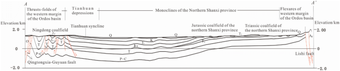
Structural profile of the E–W trending A–A′ cross section in the Ordos Basin (section position see Fig. 5)
-
(2)
The eastern North China COSS is an extensional deformation area, which is characterized by fault blocks and covers the Hebei, Shandong, and Anhui provinces east of the Taihang Mountains (Fig. 7). This subarea entered the faulting stage with the continental margin of East Asia in the Late Mesozoic, and a tectonic inversion occurred in degrees. A combination of extensional structures dominated by ladder-like normal faults, graben-horst structures, and half-graben rifts was formed, and the former compressive structural patterns were destroyed.
Fig. 7 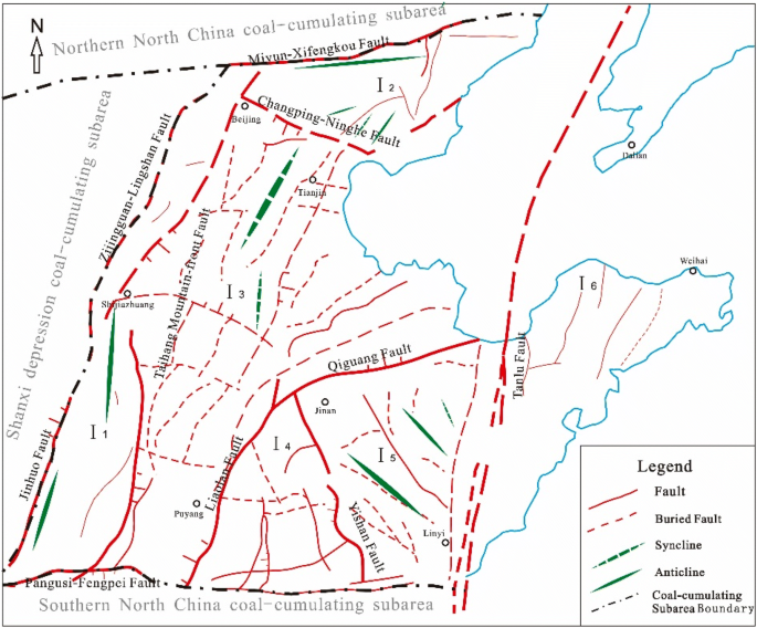
Diagram of the coalfield structures in the Eastern North China coal occurrence structural subarea. I1–Eastern foothills of the Taihangshan coal occurrence fault block belt; I2–Southern foothills of the Yanshan coal occurrence fold belt; I3–North China plain coal occurrence fault depression belt; I4–Western Shandong coal occurrence fault depression belt; I5–Central Shandong coal occurrence fault-uplift belt; I6–Northern Shandong coal occurrence fault depression belt


4.3 South China coal occurrence structural area
The South China COSA covers the area of Southern China, which is bounded to the north by the Qinling–Dabie Mountains and to the west by the Longmen Mountain-Jinsha River. Late Permian coal measures developed throughout the area, followed by Late Triassic coal measures, and finally by Neogene coal measures only in the eastern Yunnan area. The South China COSA corresponds to the paleo-continental plate of South China. The basement of this structural area is pieced together from the Yangtze block and an orogenic system known as the Caledonian fold system. Due to the multi-stage nature of the crustal movement from the Late Paleozoic to the present, the coal measures exhibit complicated deformation and significant spatial and temporal differences. It can be divided into the Yangtze COSS and the Cathaysian COSS.
-
(1)
The basic characteristic of the deformation of the coal measures in the Yangtze COSS is the concentric annular structure (Cao et al. 1998), with the Upper Yangtze Sichun Basin as the stable center. The central Sichun coal occurrence structures are characterized by broad and gentle domes, short-axis folds, and sparse faults, and the intensity of the deformation of the coal measures increases outward toward the surrounding areas. There is a coal occurrence thrust belt through Longmen Mountain, a coal occurrence uplift belt in southern central Sichun, a coal occurrence ejective fold belt in Sichun–Chongqing, a coal occurrence trough-like fold belt in Chongqing–Hubei–Hunan–Guizhou, and a coal occurrence fault-uplift belt in the Jiangnan Orogen (Fig. 8).
Fig. 8 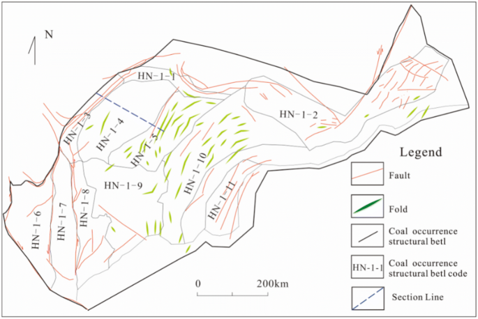
Distribution of the coal occurrence structural belts in the Yangtze COSS
-
(2)
The basement of the Cathaysian COSS is composed of pre-Devonian low-grade metamorphic rocks, the activity of which is greater than that of the Yangtze block. Due to the alternating function of the different tectonic mechanisms, e.g., extruding and stretching, since the Late Paleozoic, the deformation of the coal measures is complicated (Wang and Wang 1993; Mao and Xu 1999). Nappe and gliding nappe structures are widely developed in the coalfields, and the Fujian–Hunan–Jiangxi is famous for its colorful “Red silk dancing-like fold” metaphor (Fig. 9).
Fig. 9 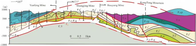
Geological profile of the Datian Mine in Shangjing County, Fujian, SE China (section position see Fig. 10)


Throughout the South China COSA, the intensity of the tectonic deformation and magmatic activity increases from the interior of the plate to the edge of the plate. In addition to this, the structural framework of the coalfield is obviously controlled by regional uplift and depression. From the coastal volcanics in Fujian–Zhejiang to the Yangtze block, a series of large NE–NNE trending uplifts and depressions are arranged in alternating order (Fig. 10). In addition, the combination law of the banding deformation zones and the NE–NNE trending distribution is obvious (Cao et al. 1998; Wang et al. 2007).

Distribution of the coal occurrence structural belts in the Cathaysian coal occurrence structural subarea

Division of the coal occurrence structural units in the Northwest China coal occurrence structural area
4.4 Northwest China coal occurrence structural area
The Northwest China coal occurrence structural area crosses several first-level tectonic units, such as the Tinashan–Xingmeng orogenic system, the Tarim continental block, and the Qinling–Qilianshan–Kunshan orogenic system. The Early-Middle Jurassic coal-accumulating basin formed in an extensional geodynamic environment, which formed after the orogenic period. Differences in tectonic setting and basement structure resulted in the observed diversity of coal accumulation and later deformation of the coal-bearing basin. Due to the collision of the Indian Plate and the Eurasian Plate since the final stage of the Mesozoic, the basins in northwest China experienced an inversion of different degrees and formed a regenerated foreland basin. The general coal occurrence structures in the coal-bearing basin are described as having a steep edge and flat bottom, i.e., a thrust nappe system developed at the edge of the basin, while the framework of the inner basin is characterized by deeply buried fault blocks with simpler structural deformation. With an extremely large coal occurrence basin as its center, the Northwest China coal occurrence structural area can be divided into three coal occurrence structural units (Fig. 11), the Junggar Basin COSS, the Tarim Basin COSS, and the Qilianshan–Kunlun Mountains COSS.
-
(1)
The Junggar Basin COSS includes the Junggar coal-bearing basin and the Turpan–Hami coal-bearing basin in the Tianshan–Xingmeng orogenic system, with Precambrian crystalline basement throughout. This subarea includes seven coal occurrence structural belts, which exhibit a concentric annular structure within the deformation zones. The degree of structural complexity gradually increases from the center outward. Tight-isoclinal folds and thrust nappe or thrust structures developed on the periphery of the basin, while the coal measures were highly compressed. In contrast, the inner basin was mainly deformed by broad and gentle folds (Fig. 12).
Fig. 12 
Structural profile of an N–S trending cross section in the Junggar Basin coal occurrence structural subarea (section position see Fig. 11)
-
(2)
The Tarim Basin COSS is composed of the surrounding orogenic belts and the rigid block between the Tianshan orogenic belt and the Kunlun orogenic belt. Its northern margin and southern margin are the thrust nappe tectonic belts, and the southeast margin is the Altyn fault. The deformation of the coal measures exhibits concentric annular features. The coal measures in the outer annulus are highly deformed and are characterized by tight-isoclinal-overturned folds and associated thrust faults. The coal measures are deeply buried in the inner basin and are transferred into a combination of fault blocks, which have wave-like or horizontal strata. The cross sections shave steep edges and a flat bottom or a W-shape (Fig. 13).
Fig. 13 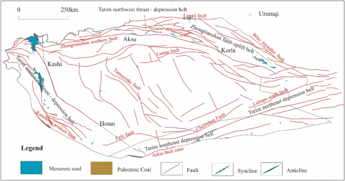
Diagram of the structural outline in the Tarim Basin coal occurrence structural subarea
-
(3)
The Qilianshan–Kunlun Mountains COSS is bounded on the east by the Erlashan fault and the Liupanshan fault, on the south by the Kunzhong fault, and on the west mainly by the Altyn fault with the Beishan partway across the Altyn fault. This structural subarea covers the distribution area of the Early-Mid Jurassic coal measures within the Qilian orogenic belt and the Qaidam block. Due to the ramp compression deformation environment of this subarea, the coal measures show a parallel banded distribution with an NW–SE trend. The folds and thrust nappe structures are fairly well developed, with gliding structures partially developed, and the coal measures commonly present as fault blocks. Based on the distribution and deformation characteristics of the Early-Mid Jurassic coal measures, this subarea can be divided into several coal occurrence structural belts, which feature parallel banding deformation, i.e., the Alxa fault depression belt, the Qilian ramp-depression belt, the Hexi corridor ramp-depression belt, the Northern Qaidam thrust belt, and the Eastern Kunlun fault-uplift belt (Fig. 14).
Fig. 14 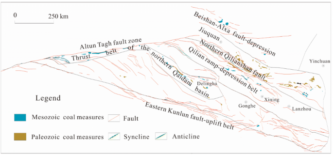
Diagram of the structural outline in the Qilianshan–Kunlun Mountains coal occurrence structural subarea


4.5 Yunnan–Tibet coal occurrence structural area
The Yunnan–Tibet COSA tectonically belongs to the Tethys category, and it has a complicated geological evolution. Taking the Tibet–Sanjiang orogenic system as the main body, this area comprises blocks belonging to the Eurasian continent and the Gandwana continent and the suture zones between them. The coal measures mainly accumulated on the northern Tibetan Plateau and in western Yunnan, and they are mostly small coal-bearing blocks, which are controlled by NW–SE trending deep faults and were destroyed during the later coal-forming period (Tan et al. 2016; Qiao et al. 2019). The intense neo-tectonics formed the highly developed folds and faults in the coal-bearing basins. Small-scale coal-bearing blocks, with a scattered distribution, are rarely developed (Fig. 15).

Diagram of the coalfield structure in the Yunnan–Tibet coal occurrence structural area
The Yunnan–Tibet COSA can be divided into two coal occurrence structural subareas and six coal occurrence structural belts.
-
(1)
The Northern Tibet COSS includes the Tumen–Baqing fold belt and the Qingnan–Changdu fold-thrust belt on the northern Tibetan Plateau. Coal measures of marine-terrigenous facies formed during the Late Paleozoic and the Triassic are mainly located on Tanggula Mountain in the north and in the Changdu block in eastern Tibet. The thickness of the strata, which has poor coal-bearing properties, varies greatly, and the structure of the coal seam is complex. This deposit experienced strong later deformation including the formation of linear folds that are NWW trending thrust nappe structures in the north and NNW trending thrust nappe structures in the east, resulting in fragmented coal-bearing blocks and intensively deformed coal seams.
-
(2)
The Western Yunnan COSS includes the Lanping–Puer thrust-fold belt, the Baoshan–Lincang strike-slip fault-subside belt, and the Tengchong–Luxi fault depression belt. The Cenozoic strike-slip faults are significant features, and the Western Yunnan area is controlled by the activity of the fault, with highly developed small-scale intermountain basins. In addition, coal accumulation occurred in the Neogene. Located in a tectonically active belt, the coal-bearing properties of this subarea are greatly inferior to the contemporary basin group in the Eastern Yunan area, which has the Yangtze platform as its basement.
5 Structural types and evolution of the coal-bearing basins
The present occurrence status of the coal resources is the result of the synthesis of multiple tectonic movements of coal-bearing basins and coal-bearing strata over an extended time period. The structural-depositional basin that occurs with coal accumulation is known as a coal-forming prototype basin. Then, the coal-forming basin was destroyed, inverted, and superimposed during multiple tectonic movements. The coal-bearing strata underwent deformation and displacement, such as uplift and erosion or subsidence and deep burial, and they lost their original continuity and integrity. It was segmented into coal-bearing blocks with different sizes and depths. Currently, these blocks are the object of resource evaluation, exploration, and development. In fact, the majority of today’s coal-bearing basins are residual basins, even though they do not have the geometry of a basin, regardless of the geological structure and geographical landscape. Therefore, the term coal occurrence structural unit is recommended to describe the characteristics of the occurrence of coal-bearing strata in the present day, while coal-bearing basin is mainly used to describe a coal-forming prototype basin.
5.1 Classification index of coal-forming basins
Researchers in China and abroad have already proposed different classifications for sedimentary basins and coal-forming basins based on different perspectives (Lyons and Rice 1986; Beaumont and Tankand 1987; Li 1988; Mang et al. 1994; Ren 1993; Ingersoll and Busby 1995; Liu 2008). Based on the summary of previous studies, the potential evaluation of coal resources in this study was used to conduct a comprehensive study on the classification of coal-forming prototype basins based on seven aspects: the structural pattern, basement properties, morphological structure, the scale of basins, geodynamic environment, paleogeography, and coal accumulation (Table 2).
5.2 Classification of coal-forming basins in the main coal accumulation periods
According to the above-described criteria, the comprehensive types of coal-forming basins in the main coal occurrence periods are classified in Tables 3 and 4.
5.3 Tectonic evolution of coal-forming basins
Since the Late Paleozoic, the Chinese continent has experienced four major tectonic cycles: the Hercynian movement, the Indosinian movement, the Yanshan movement, and the Himalayan movement. The differences in tectonic movements and tectonic positions determined the different types of coal-forming basins in the different coal occurrence periods, while the different tectonic movements after the coal forming activities resulted in differences in tectonic evolution and the later deformation of coal-forming basins. According to the severity of the damage to the structures of the coal-forming basins, today’s coal-bearing basins, which are called residual basins, can be divided into three types: weakly deformed, transitional, and highly deformed (Mang et al. 1994). By utilizing the fact that coal-forming prototype basins, which experienced polycyclic tectonic movements, can turn into coal occurrence structural units through different levels of decomposition, destruction, inversion, and superposition, the corresponding relationship between the major coal-forming basins and the coal occurrence structural units was established and was used to reveal the formation and evolution of the structural framework of coalfields.
6 Coal-controlling structural patterns
6.1 Structural control on coal
Coalfield geologists in China have been aware of the full control of structures on the formation and deformation of coal beds for a long time, and gradually, the concept of structural control on coal was formed (Han and Yang 1980; Huang and Xia 1991; Gao et al. 1996). The meaning of the structural control on coal can be understood in two ways. In a broad sense, the structural control on coal indicates the control of tectonics on the accumulation and preservation of coal. In a narrow sense, structural control indicates the control of the structural features and structural deformation on the formation and occurrence of coal.
The formation and evolution of structures in coalfields is a process consisting of several stages of decomposition and destruction of coal-forming prototype basins by tectonics, deformation, and the displacement of coal measures and coal seams; the loss of original continuity and integrity; and formation of separate coal occurrence structural units and coal-bearing blocks. From the perspective of the evaluation and prospecting of resources, structural patterns play a decisive role in the occurrence of coal seams. Therefore, from the perspective of the development and utilization of coal resources, special attention was paid to the control of structural features or structural deformation on the occurrence status of coal seams, and the concept of coal-controlling structural styles was proposed (Cao 2007).
6.2 Coal-controlling structural styles and their basic types
Structural styles are the general features and patterns of a group of structures or certain structural characteristics, i.e., the summation of tectonic deformation during the same period or structures formed under the same stress. The purpose of the study of structural styles is to reveal the law of development of geological structures and to establish a geological structural model. Therefore, when geological exploration data are insufficient, a possible tectonic framework can be determined, and the prediction of structures can be made based on the structural styles. The concept of structural styles has been widely used in the structural study of orogenic belts and basins (Harding and Lowell 1979; Suo 1985; Lowell 1985; Liu 1993).
Coal-controlling structural styles are proposed according to the evaluation and development of coal resources, the characteristics of the structural styles that control the formation, and the tectonic evolution and occurrence status of coal measures and coal seams. They are the important components of regional structural styles, but they are not the only ones.
Classification of coal-controlling structural styles was carried out using geodynamic classification. Based on the synthesis of the results of the potential evaluation of coal resources in every province, the classification of coal-controlling structural styles was further improved (Cao 2007; Cheng et al. 2010), and it can be summarized into six groups of coal-controlling structural styles: extensional structural styles, compressional structural styles, shearing and rotational structural styles, inversion structural styles, sliding structural styles, and syn-depositional structural styles (Table 5).
6.3 Distribution of coal-controlling structural styles
With coal resources widely distributed throughout China, the spatial and temporal difference in the tectonic evolution of coal-forming basins is significant, and as the basic element of the structural control on coal, coal-controlling structural styles are the comprehensive result of the different tectonics that occurred during the geological evolution of the coal measures. The distribution of the coal-controlling structural styles varies in the different coal occurrence structural units, and thus, they determine the key to the use of structural study for the evaluation of coal resources.
-
(1)
The Northeast COSA is dominated by extensional structural styles, and compressional structural styles and positive inversions are developed in the eastern coal occurrence structural subarea, with strike-slip structural styles developed along the Tanlu fault.
-
(2)
The North China COSA features a concentric annular structure of deformation zones. The edge of this area mainly developed compressional structural styles. In contrast to this, the extensional structural styles are mainly developed inside. Negative inversion is widely developed in the eastern North China coal occurrence structural subarea, and the western Henan coal-bearing area, which is located in the southern North China coal occurrence subarea, is famous for sliding structural styles.
-
(3)
The South China COSA has relatively structurally complex coalfields and is dominated by compressional structural styles and positive inversion. Especially in eastern South China, decollements, which have a gently dipping fault as the key structure, are widely developed. This is a key element in determining the occurrence status of coal measures and the effect of coal prospecting.
-
(4)
The Northwest China COSA is mainly dominated by compressional structural styles and positive inversion, while the North Xinjiang coal occurrence structural subarea, which is mainly composed of the Junggar Basin, and the South Xinjiang coal occurrence structural subarea, which is mainly composed of the Tarim Basin, feature a concentric annular structure of deformation zones. Thrust folds are located at the edges of the basins, and the basin interiors are dominated by fault blocks.
-
(5)
The Yunnan–Tibet COSA is dominated by compressional structural styles, while shearing structural styles are developed in the western Yunnan coal occurrence structural subarea.
7 Conclusions
Potential evaluation of coal resources was carried out based on the current occurrence status of coal measures and coal seams. The original coal seams, which had horizontal and continuous distributions, experienced later tectonic movements and were segmented into coal-bearing blocks of different sizes and depths by deformation and displacement. These blocks are the object of resource evaluation, exploration, and development. The complexity of the geological conditions in China results in significant spatial and temporal differences in the tectonic frameworks of its coalfields. Consequently, strengthening the structural study of coalfields and clearly determining the structural factors controlling the occurrence status of coal measures is necessary for the potential evaluation of coal resources.
Change history
25 June 2020
The original publication of the article contains incorrect notes in Fig. 1. The correct version of notes in Fig. 1 is provided in this erratum.
References
Beaumont C, Tankand AJ (1987) Sedimentary Basin-forming mechanism. Can Soc Pet Geol Mem 12:117–146
Cao DY (2007) Structural deformation and coal-controlling structural styles in coalfields. New developments of coal resources and safely mining technology. China Coal Industry Publishing House, Beijing, pp 1–6
Cao DY (2018) Tectonnic framework of coalfields and tectonic control of coalseams in China. Science Press, Bejing
Cao DY, Jing YL, Qiu GZ, Zhang DM, Wang Y (1998) Zoning of deformation of coal measures in China. J China Coal Soc 23(5):449–454
Cao DY, Zhang SR, Mu XS, Fu ZH (1999) Study on control factors of deformation of coal measures in China. J China Univ Min Technol 28(1):25–28
Cao DY, Tan JQ, Chen LM, Guo AJ, Li HT, Liu K (2013) Coal resources potential evaluation and coal occurrence tectonics in China. Coal Sci Technol 41(7):5–9
Cao DY, Guo AJ, Chen LM, Li HT, Liu K, Tan JQ (2016) New interpretation of coalfield tectonic evolution: from coal-forming basins to coal-bearing tectonic units. Coal Geol Explor 44(1):1–8
Che ZC, Luo JH, Liu L (2012) Regional tectonics in China and surrounding areas, 2nd edn. Science Press, Bejing
Cheng AG, Cao DY, Yuan TX (2010) Technical requirements for coal resources potential evaluation. Geological Publishing House, Beijing
Cheng AG, Cao DY, Yuan TX (2016) China occurrence regularity of coal resources and resource evaluation. Science Press, Beijing
Gao WT, Cao DY, Qian GM (1996) Types of structural control on coal. Coal Geol Explor 6:19–24
Han DX, Yang Q (1980) Coalfield geology in China (Second part). China Coal Industry Publishing House, Beijing
Harding TP, Lowell JD (1979) Structural styles, their plate tectonic habitats and hydrocarbon traps in petroleum provinces. AAPG Bull 63:1016–1058
Huang KX, Xia YC (1991) Generality of structural control on coal. China Coal Industry Publishing House, Beijing
Ingersoll RV, Busby CJ (1995) Tectonic of sedimentary basins. Tectonic of sedimentary basins. Cambridge, Blakwell Science, pp 1–51
Li ST (1988) Faulted basin analysis and coal accumulation rules. Geological Publishing House, Beijing
Li TD (2006) Main advances and achievement in the special-subject study of the 3D lithospheric structure of China. Geol China 33:689–699
Liu HF (1993) Dynamic classification of sedimentary basins and their structural styles. Earth Sci J China Univ Geosci 18(6):699–724
Liu CY (2008) Dynamics of sedimentary basin and basin reservoir (ore) forming system. J Earth Sci Environ 30:1–23
Lowell JD (1985) Structural styles in petroleum exploration. OGCI, Tulsa, pp 1–43
Lyons PC, Rice CL (1986) Paleoenvironmental and tectonic controls in coal-forming basins of United States. Geological Society of America Special Paper 210
Ma WP (1992) Analysis of regional tectonics—methodology and China block tectonics. Geological Publishing House, Beijing
Mang DH, Yang BZ, Lin ZP (1994) Coal-bearing basin structures in China. Geological Publishing House, Bejing
Mao JH, Xu HL (1999) Prediction and evaluation of coal resources in China. Science Press, Beijing
Qiao JW, Wu GQ, Song SY (2019) Coal occurrence law and resource potential evaluation in Qinghai–Tibet Plateau. Science Press, Beijing
Ren WZ (1993) Principle and methodology in coal-bearing basin analysis. China Coal Industry Publishing House, Beijing
Ren JS, Chen TY, Niu BG (1990) Tectonic evolution of the continental lithosphere and metallogeny in Eastern China and adjacent areas. Science Press, Beijing
Suo ST (1985) Tectonic analysis. China University of Geosciences Press, Wuhan
Tan JQ, Ma ZK, Gao KF, Song SY, Cao DY (2016) Control effect of plate tectonics on coal measures in northern Qinghai–Tibet Plateau. J China Coal Soc 41(2):286–293
Wan TF (2011) Tectonics in China. Geological Publishing House, Beijing
Wang WJ, Wang X (1993) Nappe, decollement structure and coal prospecting in eastern China. China University of Mining and Technology Press, Xuzhou
Wang GL, Ju YW, Zheng ML (2007) Energy basin tectonics in northern China. China University of Mining and Technology Press, Xuzhou
Acknowledgements
This study was financially supported by the Geological Survey Project of China Geological Survey National Potential Evaluation of Coal Resources project (121211121043) and the National Natural Science Foundation of China (41572141, 41772156).
Author information
Authors and Affiliations
Corresponding author
Ethics declarations
Conflict of interest
The authors declare no competing financial interest.
Rights and permissions
Open Access This article is licensed under a Creative Commons Attribution 4.0 International License, which permits use, sharing, adaptation, distribution and reproduction in any medium or format, as long as you give appropriate credit to the original author(s) and the source, provide a link to the Creative Commons licence, and indicate if changes were made. The images or other third party material in this article are included in the article's Creative Commons licence, unless indicated otherwise in a credit line to the material. If material is not included in the article's Creative Commons licence and your intended use is not permitted by statutory regulation or exceeds the permitted use, you will need to obtain permission directly from the copyright holder. To view a copy of this licence, visit http://creativecommons.org/licenses/by/4.0/.
About this article

Cite this article
Cao, D., Wang, A., Ning, S. et al. Coalfield structure and structural controls on coal in China. Int J Coal Sci Technol 7, 220–239 (2020). https://doi.org/10.1007/s40789-020-00326-z
Received:
Revised:
Accepted:
Published:
Issue Date:
DOI: https://doi.org/10.1007/s40789-020-00326-z