
Abstract
Inland Marsh (IM) is a type of wetland characterized by the presence of non-woody plants as grasses, reeds or sedges, with a water surface smaller than 25% of the area. Historically, these areas have been suffering impacts related to pollution by urban, industrial and agrochemical waste, as well as drainage for agriculture. The IM delineation allows to understand the vegetation and hydrodynamic dynamics and also to monitor the degradation caused by human-induced activities. This work aimed to compare four machine learning algorithms (classification and regression tree (CART), artificial neural network (ANN), random forest (RF), and k-nearest neighbors (k-NN)) using active and passive remote sensing data in order to address the following questions: (1) which of the four machine learning methods has the greatest potential for inland marshes delineation? (2) are SAR features more important for inland marshes delineation than optical features? and (3) what are the most accurate classification parameters for inland marshes delineation? To address these questions, we used data from Sentinel 1A and Alos Palsar I (SAR) and Sentinel 2A (optical) sensors, in a geographic object-based image analysis (GEOBIA) approach. In addition, we performed a vectorization of a 1975 Brazilian Army topographic chart (first official document presenting marsh boundaries) in order to quantify the marsh area losses between 1975 and 2018 by comparing it with a Sentinel 2A image. Our results showed that the method with the highest overall accuracy was k-NN, with 98.5%. The accuracies for the RF, ANN, and CART methods were 98.3%, 96.0% and 95.5%, respectively. The four classifiers presented accuracies exceeding 95%, showing that all methods have potential for inland marsh delineation. However, we note that the classification results have a great dependence on the input layers. Regarding the importance of the features, SAR images were more important in RF and ANN models, especially in the HV, HV + VH and VH channels of the Alos Palsar I L-band satellite, while spectral indices from optical images were more important in the marshes delineation with the CART method. In addition, we found that the CART and ANN methods presented the largest variations of the overall accuracy (OA) in relation to the different parameters tested. The multi-sensor approach was critical for the high OA values found in the IM delineation (> 95%). The four machine learning methods can be accurately applied for IM delineation, acting as an important low-cost tool for monitoring and managing these environments, in the face of advances in agriculture, soil degradation and pollution of water resources due to agrochemical dumping.


References
Augusteijn MF, Warrender CE (1998) Wetland classification using optical and radar data and neural network classification. Int J Remote Sens 19:1545–1560. https://doi.org/10.1080/014311698215342
Baghdadi N, Bernier M, Gauthier R, Neeson I (2001) Evaluation of C-band SAR data for wetlands mapping. Int J Remote Sens 22:71–88. https://doi.org/10.1080/014311601750038857
Baker C, Lawrence R, Montagne C, Patten D (2006) Mapping wetlands and riparian areas using Landsat ETM+ imagery and decision-tree-based models. Wetlands 26:465. https://doi.org/10.1672/0277-5212(2006)26[465:mwarau]2.0.co;2
Bao Y, Ren J (2011) Wetland Landscape classification based on the BP neural network in DaLinor Lake Area. Procedia Environ Sci 10:2360–2366. https://doi.org/10.1016/J.PROENV.2011.09.368
Behrens T, Scholten T (2007) A comparison of data mining techniques in predictive soil mapping. Dev Soil Sci 31:353–617. https://doi.org/10.1016/S0166-2481(06)31025-2
Belluco E, Camuffo M, Ferrari S et al (2006) Mapping salt-marsh vegetation by multispectral and hyperspectral remote sensing. Remote Sens Environ 105:54–67. https://doi.org/10.1016/j.rse.2006.06.006
Blaschke T, Hay GJ, Kelly M et al (2014) Geographic object-based image analysis: towards a new paradigm. ISPRS J Photogramm Remote Sens 87:180–191. https://doi.org/10.1016/j.isprsjprs.2013.09.014
Bourgeau-Chavez LL, Riordan K, Powell RB et al (2009) Improving wetland characterization with multi-sensor, multi-temporal SAR and optical/infrared data fusion. In: Jedlovec G (ed) Advances in geoscience and remote sensing, 1st edn. InTech, London
Breiman L (2001) Random forests. Mach Learn 45:5–32. https://doi.org/10.1023/A:1010933404324
Breiman L, Friedman J, Stone CJ, Olshen RA (1984) Classification and regression trees Regression trees. Taylor & Francis, Oxfordshire
Brenner V (2016) Methodological proposal for renaturation of rectified section of the Gravataí River. Federal University of Rio Grande do Sul
Brock MA, Smith RGB, Jarman PJ (1999) Drain it, dam it: Alteration of water regime in shallow wetlands on the New England Tableland of New South Wales, Australia. Wetl Ecol Manag 7:37–46. https://doi.org/10.1023/A:1008416925403
Chatziantoniou A, Psomiadis E, Petropoulos G (2017) Co-Orbital Sentinel 1 and 2 for LULC mapping with emphasis on wetlands in a mediterranean setting based on machine learning. Remote Sens 9:1259. https://doi.org/10.3390/rs9121259
Chimner RA, Bourgeau-Chavez L, Grelik S et al (2019) Mapping mountain peatlands and wet meadows using multi-date, multi-sensor remote sensing in the Cordillera Blanca. Peru Wetlands. https://doi.org/10.1007/s13157-019-01134-1
Clevers JGPW, Leeuwen HJC Van, Sensing R, Verhoef W (1989) Estimanting apar by means of vegetation indeces: a sensitivity analysis. In: XXIX ISPRS congr tech comm VII interpret photogr remote sens data, pp 691–698
Cowardin LM, Carter V, Golet FC, LaRoe ET (1979) Classification of wetlands and deepwater habitats of the United States. Washigton
Craft C, Craft C (2016) Inland marshes. In: Creat restoring wetl, pp 95–127. https://doi.org/10.1016/B978-0-12-407232-9.00005-1
Dabboor M, Brisco B (2018) Wetland monitoring and mapping using synthetic aperture radar. In: Wetlands management: assessing risk and sustainable solutions. Intechopen, London, p 13
Deering DW (1975) Measuring forage production of grazing units from landsat MSS data. In: Proc 10th int symp remote sens environ, pp 1169–1178
Delegido J, Verrelst J, Alonso L, Moreno J (2011) Evaluation of sentinel-2 red-edge bands for empirical estimation of green LAI and chlorophyll content. Sensors 11:7063–7081
de França FRS, Amaral HCDJ (2013) Aplicação de Técnicas de Mineração de Dados para o Mapeamento do Conhecimento na Aprendizagem de Programação: Uma Estratégia Baseada na Taxonomia de Bloom. In: Congresso Brasileiro de Informática na Educação. UNICAMP, Campinas, pp 759–768
Dronova I (2015) Object-based image analysis in wetland research: a review. Remote Sens.
Dubeau P, King DJ, Unbushe DG, Rebelo LM (2017) Mapping the Dabus Wetlands, Ethiopia, using random forest classification of Landsat PALSAR and topographic data. Remote Sens. https://doi.org/10.3390/rs9101056
Escadafal R (1989) Remote sensing of arid soil surface color with Landsat thematic mapper. Adv Space Res 9:159–163
Evans TL, Costa M, Telmer K, Silva TSFF (2010) Using ALOS/PALSAR and RADARSAT-2 to map land cover and seasonal inundation in the Brazilian Pantanal. IEEE J Sel Top Appl Earth Obs Remote Sens 3:560–575. https://doi.org/10.1109/JSTARS.2010.2089042
Evans TL, Costa M, Tomas WM, Camilo AR (2014) Large-scale habitat mapping of the Brazilian Pantanal wetland: a synthetic aperture radar approach. Remote Sens Environ 155:89–108. https://doi.org/10.1016/j.rse.2013.08.051
Fantin-Cruz I, Pedrollo O, Castro NMR et al (2011) Historical reconstruction of floodplain inundation in the Pantanal (Brazil) using neural networks. J Hydrol 399:376–384. https://doi.org/10.1016/j.jhydrol.2011.01.014
Ferreira-Ferreira J, Silva TSF, Streher AS et al (2015) Combining ALOS/PALSAR derived vegetation structure and inundation patterns to characterize major vegetation types in the Mamirauá Sustainable Development Reserve, Central Amazon floodplain, Brazil. Wetl Ecol Manag 23:41–59. https://doi.org/10.1007/s11273-014-9359-1
Franklin S, Ahmed O (2017) Object-based Wetland Characterization Using Radarsat-2 Quad-Polarimetric SAR Data, Landsat-8 OLI Imagery, and Airborne Lidar-Derived Geomorphometric Variables. Photogramm Eng Remote Sens 83:27–36. https://doi.org/10.14358/PERS.83.1.27
Furtado LF, Silva TSF, Novo EML (2016) Dual-season and full-polarimetric C band SAR assessment for vegetation mapping in the Amazon várzea wetlands. Remote Sens Environ 174:212–222. https://doi.org/10.1016/J.RSE.2015.12.013
Gao B (1996) NDWI—A normalized difference water index for remote sensing of vegetation liquid water from space. Remote Sens Environ 58:257–266
Gayol MP, Morandeira NS, Kandus P (2019) Dynamics of shallow lake cover types in relation to Paraná River flood pulses: assessment with multitemporal Landsat data. Hydrobiologia 833:9–24. https://doi.org/10.1007/s10750-018-3847-x
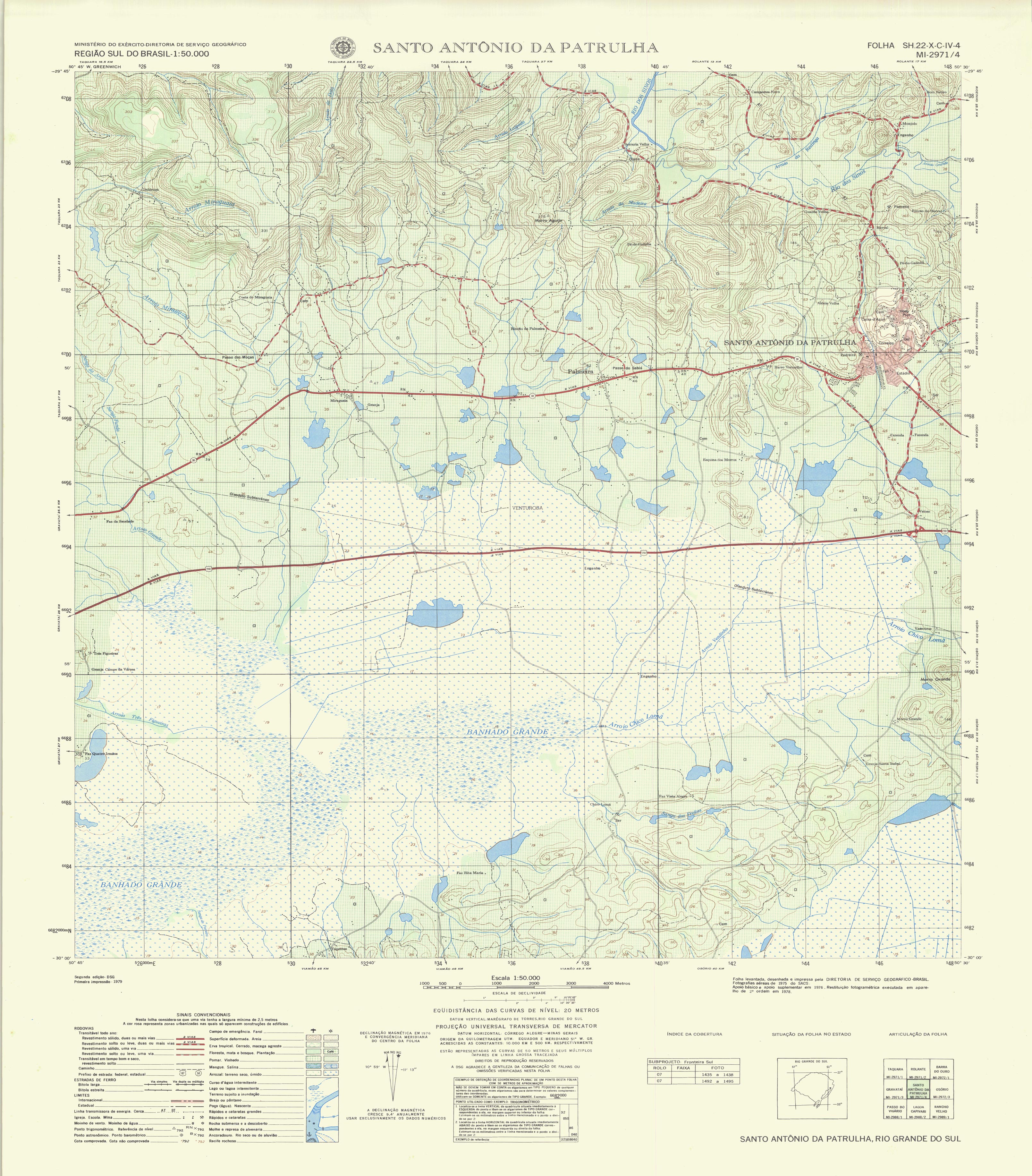
Geographic Service Directorate (1975) Topographic chart. In: Brazilian Army. https://www.quoos.com.br//carta1dl/1dl_ASX139santo_antonio_da_patrulha.jpg. Accessed 26 Aug 2019
Ghedira H, Bernier M, Ouarda TBMJ (2000) Application of neural networks for wetland classification in RADARSAT SAR imagery. In: IGARSS 2000. IEEE 2000 International Geoscience and Remote Sensing Symposium. IEEE, pp 675–677
Girolamo Neto CN (2014) Potencial de técnicas de mineração de dados para o mapeamento de áreas cafeeiras. Instituto Nacional de Pesquisas Espaciais
Gitelson AA, Kaufman YJ, Merzlyak MN (1996) Use of a green channel in remote sensing of global vegetation from EOS-MODIS. Remote Sens Environ 58:289–298
Grimson R, Gayol MP, Grimson R, et al (2019) Freshwater marsh classification in the Lower Paraná River floodplain: an object-based approach on multitemporal X-band COSMO- SkyMed data. https://doi.org/10.1117/1.JRS.13.014531
Guasselli L a. (2005) Dinâmica da vegetação no banhado do Taim, RS
Guo G, Wang H, Bell D et al (2003) KNN model-based approach in classification. Springer, Berlin, Heidelberg, pp 986–996
Gurney K (1997) An introduction to neural networks, 1st edn. Routledge, New York
Han J, Kamber M, Pei J (2012) Data mining: concepts and techniques, 3rd edn. Elsevier, Waltham
Hand DJ (2007) Principles of data mining. Drug Saf 30:621–622. https://doi.org/10.2165/00002018-200730070-00010
Happ PN, Feitosa RQ, Bentes C, Farias R (2013) Um algoritmo de segmentação por crescimento de regiões para GPUs. Bol Ciencias Geod 19:208–226. https://doi.org/10.1590/S1982-21702013000200004
Huete AR (1988) A soil-adjusted vegetation index (SAVI). Remote Sens Environ 25:295–309
Jahncke R, Leblon B, Bush P, LaRocque A (2018) Mapping wetlands in Nova Scotia with multi-beam RADARSAT-2 Polarimetric SAR, optical satellite imagery, and Lidar data. Int J Appl Earth Obs Geoinf 68:139–156. https://doi.org/10.1016/J.JAG.2018.01.012
Jones T, Marzen L, Mitra C, Barbour M (2018) Identification and classification of geographically isolated wetlands in North Alabama using geographic object based image analysis (GeOBIA). Geocarto Int 6049:1–16. https://doi.org/10.1080/10106049.2018.1438527
Junk WJ, Piedade MTF, Lourival R et al (2014) Brazilian wetlands: Their definition, delineation, and classification for research, sustainable management, and protection. Aquat Conserv Mar Freshw Ecosyst 24:5–22. https://doi.org/10.1002/aqc.2386
Kamal M, Phinn S (2011) Hyperspectral data for mangrove species mapping: A comparison of pixel-based and object-based approach. Remote Sens 3:2222–2242. https://doi.org/10.3390/rs3102222
Kandus P, Minotti PG, Morandeira NS et al (2018) Remote sensing of wetlands in South America: Status and challenges. Int J Remote Sens 39:993–1016. https://doi.org/10.1080/01431161.2017.1395971
Kaplan G, Avdan U (2017) Mapping and Monitoring Wetlands Using SENTINEL-2 Satellite Imagery. ISPRS Ann Photogramm Remote Sens Spat Inf Sci 4:271–277
Karlson M, Gålfalk M, Crill P et al (2019) Delineating northern peatlands using Sentinel-1 time series and terrain indices from local and regional digital elevation models. Remote Sens Environ 231:111252. https://doi.org/10.1016/J.RSE.2019.111252
Kaufman YJ, Tanre D (1992) Atmospherically resistant vegetation index (ARVI) for EOS-MODIS. IEEE Trans Geosci Remote Sens 30:261–270. https://doi.org/10.1109/36.134076
Keddy P (2008) Freshwater marshes. Encycl Ecol. https://doi.org/10.1016/B978-008045405-4.00338-4
Kim YH, Hong SY, Lee H (2008) Radar backscattering measurement of a paddy rice field using multi-frequency(l, c and x) and full-polarization. Int Geosci Remote Sens Symp 4:553–556. https://doi.org/10.1109/IGARSS.2008.4779781
Kuenzer C, Knauer K (2013) Remote sensing of rice crop areas. Int J Remote Sens 34:2101–2139. https://doi.org/10.1080/01431161.2012.738946
Lacaux JP, Tourre YM, Vignolles C, Ndione JA, Lafaye M (2007) Classification of ponds from high-spatial resolution remote sensing: application to Rift valley fever epidemics in Senegal. Remote Sens Environ 106:66–74
Lawrence RL, Wright A (2001) Rule-Based Classification Systems Using Classification and Regression Tree (CART) Analysis. Photogramm Eng Remote Sens 67:1137–1142. https://doi.org/10.1016/S0034-4257(01)00247-4
Leite MG, Guasselli LA (2013) Spatio-temporal dynamics of aquatic macrophytes in Banhado Grande, Gravataí River basin. Para Onde 7:17–24
Macrì-Pellizzeri T, Oliver CJ, Lombardo P (2002) Segmentation-based joint classification of SAR and optical images. IEEE Proc Radar Sonar Navig 149:281–296. https://doi.org/10.1049/ip-rsn:20020714
Mahdianpari M, Salehi B, Mohammadimanesh F, Motagh M (2017) Random forest wetland classification using ALOS-2 L-band, RADARSAT-2 C-band, and TerraSAR-X imagery. ISPRS J Photogramm Remote Sens 130:13–31. https://doi.org/10.1016/j.isprsjprs.2017.05.010
Maimon O, Rokach L (2005) Introduction to knowledge discovery in databases. In: Maimon O, Rokach L (eds) data mining and knowledge discovery handbook. Springer, New York, pp 1–15
Mazzillo JRCA, Anzanello MJ (2015) Sistemática de seleção de variáveis para classificação de produtos em categorias de modelos de reposição. Gest Prod 22:201–212. https://doi.org/10.1590/0104-530X1052-13
McFeeters SK (2007) The use of the normalized difference water index (NDWI) in the delineation of open water features. Int J Remote Sens 17:1425–1432
Millard K, Richardson M (2013) Wetland mapping with LiDAR derivatives, SAR polarimetric decompositions, and LiDAR-SAR fusion using a random forest classifier. Can J Remote Sens 39:290–307. https://doi.org/10.5589/m13-038
Mitsch WJ, Bernal B, Nahlik AM et al (2013) Wetlands, carbon, and climate change. Landsc Ecol 28:583–597. https://doi.org/10.1007/s10980-012-9758-8
Mleczko M, Mróz M (2018) Wetland mapping using SAR Data from the Sentinel-1A and TanDEM-X missions: a comparative study in the Biebrza Floodplain (Poland). Remote Sens 10:78. https://doi.org/10.3390/rs10010078
Morandeira N, Grings F, Facchinetti C et al (2016) Mapping plant functional types in floodplain wetlands: an analysis of C-band polarimetric SAR data from RADARSAT-2. Remote Sens 8:174. https://doi.org/10.3390/rs8030174
Mui A, He Y, Weng Q (2015) An object-based approach to delineate wetlands across landscapes of varied disturbance with high spatial resolution satellite imagery. ISPRS J Photogramm Remote Sens 109:30–46. https://doi.org/10.1016/j.isprsjprs.2015.08.005
Na XD, Zang SY, Wu CS, Li WL (2015) Mapping forested wetlands in the Great Zhan River Basin through integrating optical, radar, and topographical data classification techniques. Environ Monit Assess 187:696. https://doi.org/10.1007/s10661-015-4914-7
Neiff JJ, Patino CA, Neiff ASP et al (2002) Response of a natural marsh to chemical and biological inputs of eutrophic waters (Saladas, Corrientes, Argentina). Rev Bras Recur Hídricos 7:53–62. https://doi.org/10.21168/rbrh.v7n3.p53-62
Neves AK (2015) O Uso de Séries Temporais e Mineração de Dados no Mapeamento de Cobertura do Solo e seus Padrões São José dos Campos. Instituto Nacional de Pesquisas Espaciais
Oliveira GG, Pedrollo OC, Castro NMR (2015) Simplifying artificial neural network models of river basin behaviour by an automated procedure for input variable selection. Eng Appl Artif Intell 40:47–61. https://doi.org/10.1016/j.engappai.2015.01.001
Ozesmi SL, Bauer ME (2002) Satellite remote sensing of wetlands. Wetl Ecol Manag 10:381–402. https://doi.org/10.1023/A:1020908432489
Pantaleoni E, Wynne RH, Galbraith JM, Campbell JB (2009) Mapping wetlands using ASTER data: a comparison between classification trees and logistic regression. Int J Remote Sens 30:3423–3440. https://doi.org/10.1080/01431160802562214
Pearson RL, Miller LD (1972) Remote mapping of standing crop biomass for estimation of the productivity of the shortgrass Prairie. Remote Sens Environ 8:1355
Pereira L, Furtado L, Novo E et al (2018) Multifrequency and Full-Polarimetric SAR assessment for estimating above ground biomass and leaf area index in the Amazon Várzea Wetlands. Remote Sens 10:1355. https://doi.org/10.3390/rs10091355
Pontius RG, Millones M (2011) Death to kappa: birth of quantity disagreement and allocation disagreement for accuracy assessment. Int J Remote Sens 32:4407–4429. https://doi.org/10.1080/01431161.2011.552923
Pope KO, Rey-Benayas JM, Paris JF (1994) Radar remote sensing of forest and wetland ecosystems in the Central American tropics. Remote Sens Environ 48:205–219. https://doi.org/10.1016/0034-4257(94)90142-2
Pratolongo P, Vicari R, Kandus P, Malvárez I (2005) A new method for evaluating Net Aboveground Primary Production (NAPP) of Scirpus giganteus (Kunth). Wetlands 25:228–232. https://doi.org/10.1672/0277-5212(2005)025[0228:ANMFEN]2.0.CO;2
Ramos RA, Pasqualetto AI, Balbueno RA, et al (2014) Mapeamento e diagnóstico de áreas úmidas no Rio Grande do Sul, com o uso de ferramentas de geoprocessamento. In: Anais do Simposio de Áreas Protegidas. Viçosa, pp 17–21
Richardson AJ, Wiegand CL (1977) Distinguishing vegetation from soil background information. Photogramm Eng Remote Sens 43:1541–1552
Rokach L, Maimon O (2005) Decision trees. Data mining and knowledge discovery handbook, 1st edn. Springer, Berlin, pp 165–192
Rouse JW, Hass RH, Schell JA, Deering DW (1973) Monitoring vegetation systems in the great plains with ERTS. In: Third earth resour technol satell symp, vol 1, pp 309–317. https://doi.org/citeulike-article-id:12009708
Ruiz LF (2019) Proposed object-based classification and post-classification of land cover and use by unmanned aerial vehicle images. Federal University of Rio Grande do Sul
Rumelhart DE, Hinton GE, Williams RJ (1986) © Learning representations by back-propagating errors. Nature 323:264–265. https://doi.org/10.1038/324227a0
Sánchez-espinosa A, Schröder C (2019) Land use and land cover mapping in wetlands one step closer to the ground : Sentinel-2 versus landsat 8. J Environ Manage 247:484–498. https://doi.org/10.1016/j.jenvman.2019.06.084
Sasser CE, Evers-Hebert E, Holm GO et al (2017) Relationships of marsh soil strength to belowground vegetation biomass in louisiana coastal marshes. Wetlands. https://doi.org/10.1007/s13157-017-0977-2
Silva RC da (2016) Estudo da dinâmica da fragilidade ambiental na Bacia Hidrográfica do Rio Gravataí, RS. Universidade Federal da Bahia
Silva TSF, Costa MPF, Melack JM (2010) Spatial and temporal variability of macrophyte cover and productivity in the eastern Amazon floodplain: a remote sensing approach. Remote Sens Environ 114:1998–2010. https://doi.org/10.1016/j.rse.2010.04.007
Simioni J, Guasselli L, Etchelar C (2017) Connectivity among Wetlands of EPA of Banhado Grande, RS Conetividade entre Áreas Úmidas, APA do Banhado Grande, RS. Braz J Water Resour. https://doi.org/10.1590/2318-0331.011716096
Simioni JPD, Guasselli LA, Nascimento VF et al (2019) Integration of multi-sensor analysis and decision tree for evaluation of dual and quad: Pol SAR in L- and C- bands applied for marsh delineation. Environ Dev Sustain. https://doi.org/10.1007/s10668-019-00442-0
Simioni JPD, Nascimento VF, Guasselli LA et al (2018) Small inner marsh area delimitation using remote sensing spectral indexes and decision tree method in southern Brazil. Rev Teledetección. https://doi.org/10.4995/raet.2018.10366
Şimşek ÇK, Ödül H (2018) Investigation of the effects of wetlands on micro-climate. Appl Geogr. https://doi.org/10.1016/j.apgeog.2018.05.018
Story M, Congalton RG (1986) Remote sensing brief accuracy assessment: a user’s perspective. Photogramm Eng Remote Sens 52:397–399
Van Beijma S, Comber A, Lamb A (2014) Random forest classification of salt marsh vegetation habitats using quad-polarimetric airborne SAR, elevation and optical RS data. Remote Sens Environ. https://doi.org/10.1016/j.rse.2014.04.010
Waheed T, Bonnell RB, Prasher SO, Paulet E (2006) Measuring performance in precision agriculture: CART-A decision tree approach. Agric Water Manag 84:173–185. https://doi.org/10.1016/j.agwat.2005.12.003
Walsh N, Bhattasali N, Chay F (2014) Mapping Tidal Salt Marshes
Wang X, Gao X, Zhang Y et al (2019) Land-cover classification of coastal wetlands using the RF algorithm for worldview-2 and Landsat 8 images. Remote Sens 11:1927. https://doi.org/10.3390/rs11161927
Webb GI, Sammut C, Perlich C et al (2011) Lazy Learning. Encyclopedia of Machine Learning. Springer, US, Boston, MA, pp 571–572
Wester SJ, Grimson R, Minotti PG et al (2018) Hydrodynamic modelling of a tidal delta wetland using an enhanced quasi-2D model. J Hydrol 559:315–326. https://doi.org/10.1016/j.jhydrol.2018.02.014
Wettschereck D, Aha DW, Mohri T (1997) A review and empirical evaluation of feature weighting methods for a class of lazy learning algorithms. Artif Intell Rev 11:273–314. https://doi.org/10.1023/A:1006593614256
White L, Brisco B, Dabboor M et al (2015) A collection of SAR methodologies for monitoring wetlands. Remote Sens 7:7615–7645. https://doi.org/10.3390/rs70607615
Xu H (2007) Modification of normalised difference water index (NDWI) to enhance open water features in remotely sensed imagery. Int J Remote Sens 27:3025–3033
Zhou Q, Jing Z, Jiang S (2003) Remote sensing image fusion for different spectral and spatial resolutions with bilinear resampling wavelet transform. In: Proceedings of the 2003 IEEE International Conference on Intelligent Transportation Systems. IEEE, Shanghai, pp 1206–1213
Acknowledgements
This study was financed by the Coordination for the Improvement of Higher Education Personnel (CAPES) agency (Grant No: 88882.438941/2019-01).
Author information
Authors and Affiliations
Corresponding author
Additional information
Publisher's Note
Springer Nature remains neutral with regard to jurisdictional claims in published maps and institutional affiliations.
Rights and permissions
About this article

Cite this article
Simioni, J.P.D., Guasselli, L.A., de Oliveira, G.G. et al. A comparison of data mining techniques and multi-sensor analysis for inland marshes delineation. Wetlands Ecol Manage 28, 577–594 (2020). https://doi.org/10.1007/s11273-020-09731-2
Received:
Accepted:
Published:
Issue Date:
DOI: https://doi.org/10.1007/s11273-020-09731-2