Changes in the Characteristics of Dry and Wet Periods in Europe (1851–2015)


1
Interdisciplinary Environmental Research Center, TU Bergakademie Freiberg, Brennhausgasse 14, 09599 Freiberg, Germany
2
Deutscher Wetterdienst, Frankfurter Str. 135, 63067 Offenbach, Germany
Atmosphere 2020, 11(10), 1080; https://doi.org/10.3390/atmos11101080
Submission received: 15 September 2020
/
Revised: 3 October 2020
/
Accepted: 5 October 2020
/
Published: 10 October 2020
(This article belongs to the Special Issue Climate Events and Extreme Weather)
Abstract
:This study spanning the period 1851–2015 explores the spatial and temporal characteristics of dry and wet periods in Europe as well as their variability and changes. It is based on up to 220 stations with monthly precipitation time series that have a varying data availability within the study period. The stations are classified into eight regions with similar climate characteristics. Dry and wet periods are analyzed using the decile method as well as the modified Rainfall Anomaly Index mRAI at the 3-month timescale. Spatial extent, duration, and frequency of dry and wet periods show a large multi-decadal variability resulting in comparatively small long-term trends over the entirety of Europe for the study periods 1901–2015 and 1951–2015. Nonetheless, several sub-regions show distinct changes—with opposite signals for northern and southern Europe. Spatial extent and duration of dry periods generally decreased, while wet periods show increases throughout the 20th century—particularly in Scandinavia. A simultaneous increase in the frequency of severely dry and wet years, respectively, is observed since the 1980s. This indicates that temperature increases across Europe may be connected with an increasing frequency of extremes at both sides of the probability density function of precipitation.
1. Introduction
Human society with its economic activities depends heavily on the availability of water. One of the most important factors in Earth’s water cycle is precipitation. The lack of precipitation (drought conditions) is negatively affecting many human activities, as does a surplus (wet conditions). Persistent lower-than-average precipitation conditions have negative impacts on agriculture and forestry [1,2,3,4], damage natural ecosystems [5,6], and lead to decreased streamflow or groundwater levels [7,8,9]. In the long run, they may even lead to soil degradation and desertification [10,11]. Heavy precipitation and long-lasting wetter-than-normal conditions may cause flashfloods [12,13] or river flooding [14,15,16,17,18], reduce yields [19,20], and contribute to groundwater contamination [21,22,23]. Thus, the study of the long-term variability and trends in precipitation at global, continental, and especially, regional scales is crucial for a targeted water resources management [24]. Many researchers already studied the characteristics and changes of dry and/or wet periods based on different indices, data sources, and study periods [24,25,26,27,28,29,30,31,32,33,34,35]. Thereby, many studies focus just on one side of the precipitation probability density function, which is mainly drought. Studies that address changes in the spatial and temporal variability of dryness and wetness simultaneously are still quite rare.
The comparison of the climatic conditions of different areas, which often are characterized by specific hydrological balances, requires standardized variables that are able to objectively capture the drought and wetness condition of a region [36]. These indices enable the analysis of various event characteristics like intensity, duration, frequency, and spatial extent [37,38,39]. Manifold indices at different temporal scales are used in the scientific literature to study precipitation and its extremes; some are defined on a daily basis and others use data in monthly resolution. Indices at timescales between 1 and 24 months are generally used if drought is to be assessed. With these diverse timescales, different perspectives of drought and related impacts may be addressed. Generally, drought is classified into meteorological, agricultural, hydrological, and socio-economic drought [40,41]. Many of the indices that are normally used to assess drought conditions can be also applied to evaluate wetness. Widely used indices among a variety of existing drought indices are the Standardized Precipitation Index (SPI) [42], the Standardized Precipitation Evaporation Index (SPEI) [43], and the Palmer Drought Severity Index (PDSI) [44]. While the SPI is based solely on precipitation, SPEI and PDSI also account for air temperature via potential evapotranspiration.
Different studies have explored the links between drought indices and observed drought impacts on different systems [45,46,47,48,49]. They present a great variability in the index timescales showing the best correlation to drought impacts and a dependence of the correlation on the climate zone, the degree of human intervention, the geological and soil properties, and the present vegetation (e.g., tree or crop species). Generally, the correlations between the drought indices SPI and SPEI and the drought impacts are comparable, with slightly higher correlations for the SPEI [46,49,50]. Rain-feed agriculture in Europe shows the best correlations of SPEI to drought impacts at timescales of 2–3 months, with the highest sensitivity to drought stress during late spring and early summer in Europe [45]. Agriculture that is more dependent on irrigation and water storage shows the highest correlation to drought indices at the timescales of 9–12 months [45]. Different timescales are relevant with respect to the water sector, with a strong dependence on the catchment characteristics [45,51,52,53]. Drought impacts on public water supply and freshwater ecosystems are explained by a combination of short (1–3 month) and seasonal (6–12 month) anomalies of SPEI and SPI, respectively [45].
Observations show recent regional changes globally and within Europe in amount, intensity, frequency, and type of precipitation [54,55,56]. Precipitation is known for its large natural variability and its trends are generally more variable—spatially and seasonally—than temperature changes [54]. Pronounced long-term precipitation trends have been observed in some European areas during the 20th century; while northern Europe became significantly wetter, dryer conditions prevailed in the Mediterranean region [57,58]. Several studies suggest drying trends for the Mediterranean area [58,59,60,61] and climate model studies project a continuation of this tendency within the 21st century [62,63,64,65]. Widespread positive trends in heavy precipitation events are associated with the increased water holding capacity of the atmosphere, while increases in drought conditions are connected to the enhanced evaporation arising from global warming [57]. Moreover, changes in precipitation extremes may be very different (even opposite) to those of precipitation means [66,67,68].
Studies on causes and processes of precipitation extremes, as well as their past and future changes received increasing attention in recent years [69,70,71]. Regional studies on precipitation extremes in Europe indicate complex and non-uniform spatial changes in precipitation patterns within the last century [56,70,72,73,74]. Extreme precipitation trends as described by those and other studies depend, e.g., on individual study periods and regions. Therefore, a division of the European dataset into sub-regions appears reasonable [75] to analyze variability and long-term changes in the characteristics of dry and wet period.
With regard to drought events, Spinoni et al. [35] provide an overview on the biggest events in Europe for 1950–2012 by combing three drought indices (SPI, SPEI, and Reconnaissance Drought Index (RDI) [76]) at the 3-month scale for meteorological and the 12-month scale for hydrological droughts. They also provide an extensive list of relevant references for the most important events. Their analysis identified pan-European drought events in 1950–1952, 1953–1954, 1972–1974, and 2003. Generally, the 1950s as well as the 1940s have been very dry [77,78,79], with the drought events of the early 1950s covering half of Europe at the timescale of 12 months [35]. Since the 1990s, rising average temperatures increasingly impact the observed severity of drought events, especially during the warm part of the year.
A recent study of Vicente-Serrano et al. [80] analyzed the long-term variability and trends in meteorological droughts in Western Europe by applying the SPI at the timescale of 3 and 12 months. Precipitation data from 199 stations spanning the period 1851–2018 were employed. According to this analysis the temporal variability of drought in Western Europe is more dominant than long-term trends with no statistically significant long-term trends present in the study domain. The largest increases in drought condition based on the SPI-3 were found for summer in the British and Irish Isles. Vicente-Serrano et al. [80] conclude that drought episodes experienced in the last two or three decades have precedents during the last 170 years and emphasize the importance of long records for assessing change. They describe the strong spatial diversity, with regions exhibiting a homogeneous temporal evolution as the main characteristic of drought variability in Western Europe.
Both the study of Spinoni et al. [35] and the one of Vicente-Serrano et al. [80] solely focus on drought, and thereby apply a selection of drought indices at the timescale of 3 and 12 months. In the present study, two indices at the timescale of 3 months are used to study the temporal and spatial variability of dry and wet conditions in Europe for up to 165 years. The focus is on event duration, frequency, and spatial extent within Europe and eight sub-regions. The choice of the indices is motivated by their straightforward computation (no distribution fitting) and the possibility of addressing long-term variations in precipitation and related dry and wet events (purely precipitation-based indices that are computed on a station base). The regional relevance of specific dry and wet periods and region-specific information on individual events is studied and particularly dry and wet years and seasons, respectively, are listed. The results and statistical properties of the two indices are compared to each other and to results obtained by other indices in the scientific literature.
2. Materials and Methods
2.1. Study Area and Database
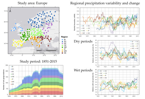
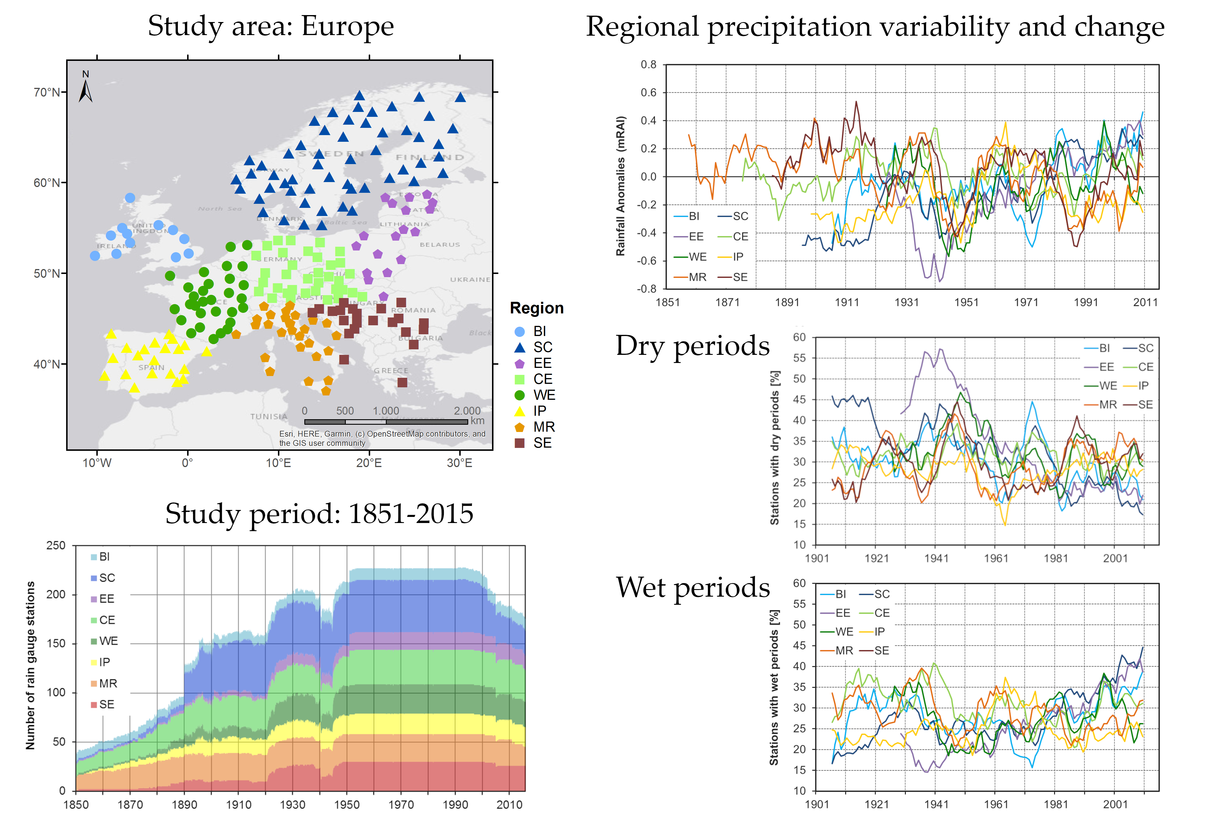
The analyses are based on monthly precipitation time series of up to 220 European meteorological stations (37°–70° N, 10° W–30° E; Figure 1a) with preferably long records. The data were obtained from the European Climate Assessment and Dataset (ECA&D; [81]), which includes more than 4000 rain gauge stations. For regional analyses and shorter study periods, much denser station networks may be applied, but we consciously restricted the analysis to a comparatively small collective fulfilling the following three criteria. First, long time series (preferably monthly precipitation data since 1851, but at least data since 1951) are used with an as high as possible data availability over the entire study period. Second, we aim at an even spatial distribution across Europe with approximately one station per 22,000 km2, which led to the exclusion of some nearby stations and the inclusion of some stations with time series not covering the entire study period. The third criteria was a high quality of the times series. Therefore, we refer to a “valid” flag in the quality control and a classification as “useful” (for a start date of 1951) with respect to homogeneity (procedure of Wijngaard et al. [82]). In order to fulfil the other two criteria, a few time series classified as doubtful for the longer periods (starting in 1851 or 1901) were included in the study.
The sub-regional climate characteristics in Europe mainly depend on latitude, distance from the sea, and local influences such as orography and land use. The stations were classified into eight sub-regions with similar precipitation characteristics (particularly the seasonal cycle and the annual precipitation totals). This allows determining regionally dependent tendencies in European dry and wet periods, as addressed in previous studies [54,70,72,73].
The stations show varying data availability within 1851–2015 (Figure 1b). Data availability reaches 25% (55 of 220 stations) in 1862 and 50% (110 of 220 stations) in 1890, but the regional distribution over Europe is quite diverse. Since the year 2000, the data availability has decreased again. Some of the stations with long precipitation time series have been closed for different reasons; other stations are now managed by private institutions that follow a restrictive data policy. A considerable proportion of the stations have been relocated, for instance to airports or other locations outside the cities. With the increasing urbanization during the 20th and 21st centuries, many stations that once were situated in the periphery are now situated in the city center, which also affects the homogeneity of some time series.
Before 1890, station distribution was densest in the regions “British Isles” (BI), “Central Europe” (CE), and “Mediterranean Region” (MR), and thus, averaging the analysis results over entire Europe would result in a bias towards those regions. Although we show this information in some of the graphics, they are not included in the statistical analysis and interpretation. The reader can decide for himself, if he wants to carefully consider also the index variations during times with restricted data availability. The Europe-wide analysis starts in 1924, when the last region reaches a data availability of at least 50%. Sub-regional results are interpreted starting from the year the regional data availability reaches 50% of the maximum number of considered stations. These are 1851 for the “Mediterranean Region” (MR), 1871 for “Central Europe” (CE), 1881 for “South-Eastern Europe” (SE), 1891 for “Scandinavia” (SC), 1894 for the “Iberian Peninsula” (IP), 1921 for “Western Europe” (WE), and 1924 for “Eastern Europe” (EE). Just for region BI (British Isles), a higher threshold of 75% data availability is used due to the low number of stations within this region; here the analyses start in 1901.
2.2. Climate Indices
We study “long-term” deviations from “normal” precipitation conditions in contrast to the often-addressed “short-term” deviations of several days to weeks. For this purpose, two straightforward indices are used that have been mainly used for drought studies. The deciles [38] were introduced by Gibbs and Maher [83] as a rainfall anomaly concept and adapted by Kininmonth [84] to study drought durations. The deciles concept can be also applied for the definition of long-lasting wet periods [85]. The second index is the modified Rainfall Anomaly Index (mRAI) [86], a modified version of the RAI [87]. It was used to identify the driest years and seasons in the studied sub-regions. Furthermore, dry and wet periods were identified on the basis of the index values. This straightforward index delivers similar results to the widely used Standardized Precipitation Index SPI [42,88]. Both indices can be calculated by very simple means and require no specific programs.
2.2.1. Decile Indicator
The decile indicator is used to identify periods with exceptional precipitation totals over long timescales of several months and not only precipitation anomalies over a fixed timescale. Advantages of the decile indicator include its easy calculation as well as its low level of underlying assumptions, while it still provides an accurate statistical measure of long-term deviations of precipitation from normal conditions. The decile-based indicator for monitoring meteorological drought events was suggested by Gibbs and Maher [81] and transcribed in analogue for wet events by Hänsel [83].
The decile indicator is calculated by computing 3-month sums of the observed precipitation totals and dividing the frequency distribution obtained for the base period (1951–2000) into ten parts —the deciles. Thereby, the first decile is the precipitation amount that is not exceeded by the lowest 10% of all 3-month sums [81,83]. Those deciles are used to define the thresholds for start and end of decile dry and wet periods, respectively. Such an event (period) starts with moderately extreme precipitation conditions, when the 3-month sum is within the first (tenth) decile range for dry (wet) periods. It ends when precipitation leaves the normal range (defined as the interval between the fourth and seventh decile—30–70%) towards the opposite precipitation extreme. A second termination rule applies for decile dry periods in regions with strong seasonal differences in precipitation totals; decile dry periods also end if the precipitation of a single month is so large that it is in or above the fourth decile of the 3-month sum (>30%). The start/end of a decile period is defined to be the last month of the respective 3-month total, as dry and wet conditions, respectively, need some time to build up.
2.2.2. Modified Rainfall Anomaly Index, mRAI
The mRAI [86] is used as a second purely precipitation-based drought index that can also be used to classify wet conditions. The mRAI standardizes the precipitation record for any desired timescale. Its computation is straightforward and does not include fitting a distribution to the precipitation data such as the computation of the widely used SPI [42]. Instead, the average of the five most extreme values (10% driest and wettest events) within 1951–2000 and the median of the precipitation totals for the respective timescale are used for the standardization:
where P = precipitation sum of the respective timescale; = median precipitation of the base period 1951–2000 for the respective timescale; = arithmetic average of the 10% most extreme precipitation sums (10th percentile for positive anomalies, 90th percentile for negative anomalies) of the base period 1951–2000; ±SF = scaling factor (positive for P > , and negative for P < ).
A scaling factor of SF = 1.7 was empirically derived and suggested [86] instead of the original scaling factor of SF = 3 [87]. Applying this scaling factor delivers similar values to the SPI, and the same classification of index values generally used for the SPI can be used (Table 1). The application of the mRAI with a scaling factor of 1.7 in a study of the summer drought of 2015 in Europe showed very similar results to the simultaneous SPI analyses [88]. For other climatic regions, the suitability of the scaling factor should be tested. Applying the mRAI concept to the climatic water balance instead of precipitation results in the Water Balance Anomaly Index WBAI [86]. It was shown that the differences between WBAI and SPEI using the same approach for calculating the potential evapotranspiration are considerably smaller than between two SPEI versions calculated based on different methods for the estimation of potential evapotranspiration [88].
2.2.3. Characteristics of Dry and Wet Periods
The studied characteristics of dry and wet periods as obtained by the two indices explained above are spatial extent, average and maximum duration as well as frequency. These characteristics are computed at the regional scale with a monthly and annual time step. Thereby, the annual time series are the basis for linear trend analyses. The graphics show the results in monthly resolution in order to illustrate also the intra-annual variability.
The spatial extent is estimated by the number of stations that show wet or dry conditions. The spatial extent is expressed as a percentage value (number of affected stations divided by the number of available station during each time step) to account for the variable number of available stations within the study period.
Applying the decile indicator directly delivers event durations (see Section 2.2.1). Dry and wet period durations based on the mRAI values are identified at the 3-month timescale. Hence, the timing of the identified dry and wet periods shall be comparable to those identified by the deciles index. A dry period starts when the mRAI drops below −1 (moderately dry conditions; see Table 1) and lasts until its values rise above zero (median conditions). Wet periods are defined analogously. They start if the mRAI is above +1 (moderately wet conditions) and last until the values drop below zero.
The average duration is computed for individual stations for the three studied 50-year periods (see the following Section 2.3) and at an annual scale for the regions. The maximum duration at the regional scale is computed by averaging the observed station maxima for each of the studied 50-year periods. Regional trends are computed based on the longest duration of all stations within the addressed region that is determined for every 12-month period.
The event frequency is represented by the number of dry and wet periods, respectively, per 10 years.
2.3. Trend Analysis
Trend analyses were done for the annual and seasonal data. Therefore, the seasons spring (months March-April-May), summer (June-July-August), autumn (September-October-November), and winter (December-January-February) were addressed. Additionally, the developments during the half years (SHY = summer half year [AMJJAS]; WHY = winter half year [ONDJFM]) were considered.
Trend analyses for the intensity of the precipitation anomalies were done using the mRAI at the respective timescale. The mRAI for December at the 12-month timescale (mRAI-12) was used for the evaluation of the annual variability and trends, while for the seasons the mRAI at the 3-month timescale (mRAI-3) and for the half years the mRAI at the 6-month timescale (mRAI-6) were used. The evaluation of changes in the spatial extent, duration, and frequency of dry and wet periods was also done based on annual and seasonal data. Here, the information of the indices that is available in monthly resolution (one value each month that looks three months backward) was aggregated to seasonal and annual data by averaging the respective monthly data.
Simple linear regression (least squares method) is used to identify the long-term changes within different study periods (e.g., 1901–2015 and 1951–2015). Although many climate elements do not fulfil the criteria of normal distribution and statistical independency, such linear trends are still used in many climate studies. Precipitation-based indices generally show a high temporal variability at different timescales and the computed linear trends strongly depend on the values at the beginning and the end of the time series. Therefore, low pass filtered series (5-, 11-, and/or 30-year moving averages) are used in the graphics instead of displaying linear trend lines. Information on the statistical significance of the linear trends is not shown, as the focus is on the long-term temporal variability of precipitation characteristics and linear trends describe those variations insufficiently.
Long-term changes in the characteristics of dry and wet periods have been also shown by comparing the averages of different periods. Due to the large temporal variability if the index values averages over 50-year periods (1866–1915, 1916–1965, and 1966–2015) are used. The averages are computed if at least half of the stations have data available for at least 25 years during the 50-year period. No statistical test is used for assessing the statistical significance of the difference between the time slice averages.
3. Results
3.1. General Characteristics of Decile Dry and Wet Periods
3.1.1. Spatial Extent
European perspective: On average 28% (29%) of the analyzed stations experienced a decile (mRAI) dry period, respectively, and 30% (26%) a wet period within 1966–2015 (Table 2). The differences between the two indices are small and lower than those between the different sub-regions. The decreasing spatial extent of dry periods over Europe and the slightly increasing spatial extent of wet periods—as visible from the comparison of the 50-year periods 1916–1965 and 1966–2015—will be addressed in Section 3.2.2 in more detail.
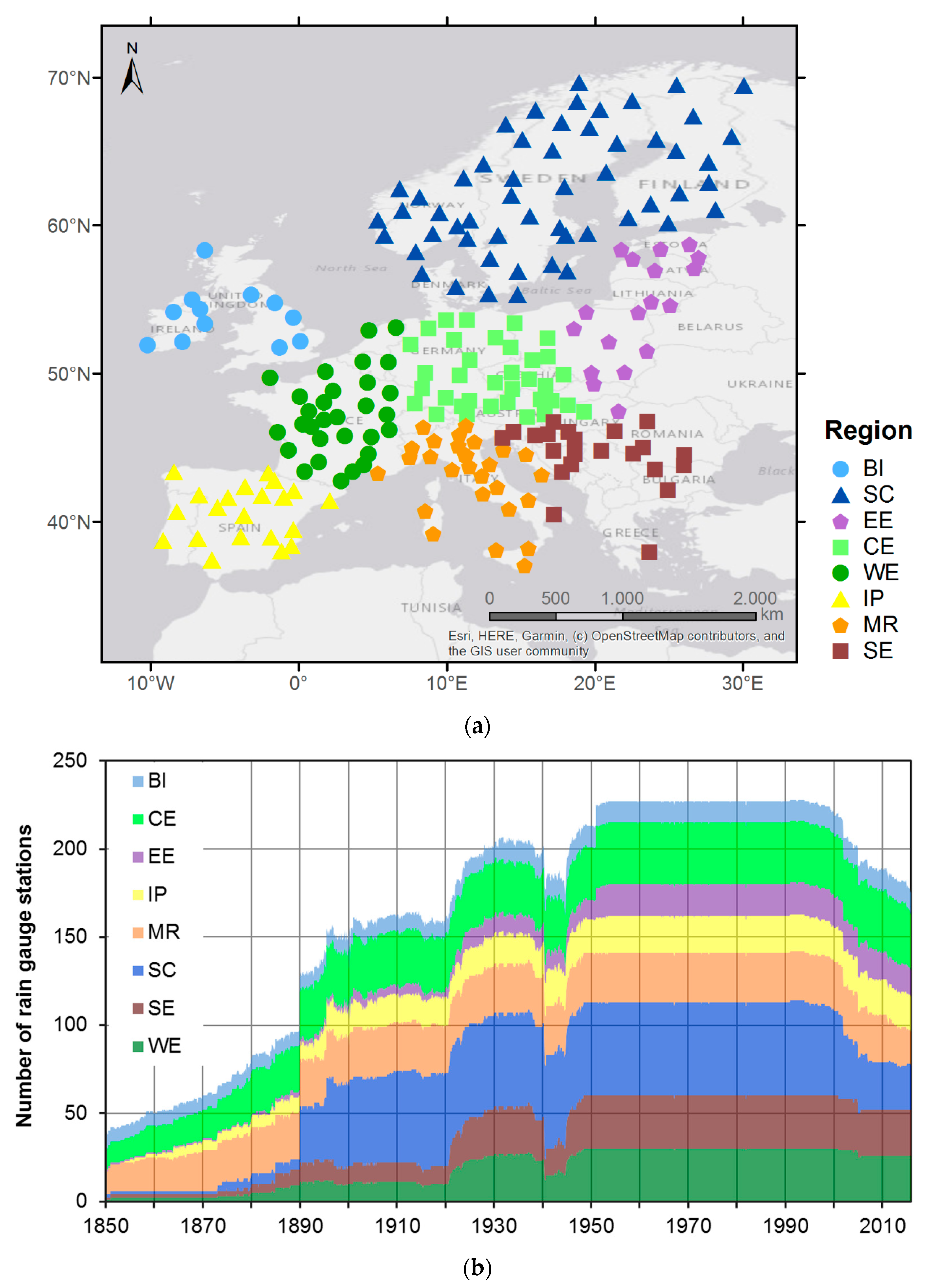
Figure 2 illustrates the characteristic spatio-temporal patterns of decile as well as mRAI periods. The plot shows the different characteristics of dry and wet periods for the entire study area and its individual sub-regions in monthly resolution. Dry and wet periods, respectively, occur more frequently and last longer during certain periods, while almost no events occur at other times (Figure 2). However, periods of clustered decile dry (wet) periods do not exclude wet (dry) spells in this particular time frame. Phases with more abundant dry periods (5-year moving average of the spatial extent of decile dry periods >32%) are 1930–1934, 1940–1958, 1970–1975, 1990–1992, 2004/05. Please note that years shortly before and after the indicated phases may also have been particularly dry, as a 5-year low pass filter was applied for identifying the phases of abundant dry periods. For instance, the values of the known drought year 2003 are slightly below the threshold of 32% of the stations showing decile dry periods due to low percentage in the known wet year 2002. Wet periods on the other hand were particularly abundant (5-year moving average of the spatial extent of decile wet periods >32%) during 1935–1939, 1968, 1979, 1996–2002, 2007–2013.
Table 3 lists the TOP20 months with the highest spatial extent of dry and wet periods, as identified by the deciles indicator and the mRAI at the 3-month timescale. The two different indices identify similar months, but there are also some months that are only identified by one of the indices. In such cases, the other index is very close to the threshold that separates the 20 highest values from the rest. Generally, the deciles index tends to identify more continuous months than the mRAI, particularly for wet periods. Many of the months with the highest percentage of dry periods are found in the 1940s to 1950s. The months 11/1945, 10–11/1947, 05/1953, 01–02/1954, 08/1976, 03/1989, and 08–9/2003 are identified by both indices. Decades with a high share of TOP20 months with regard to wet period coverage are the 1960s and the years after 2000. Both indices identify the months 10–11/1930, 05–06/1937, 12/1960, 01/1961, 03–04/1966, 12/1974, 12/2002, and 01/2003 as those with a particularly high percentage of stations with wet period conditions.
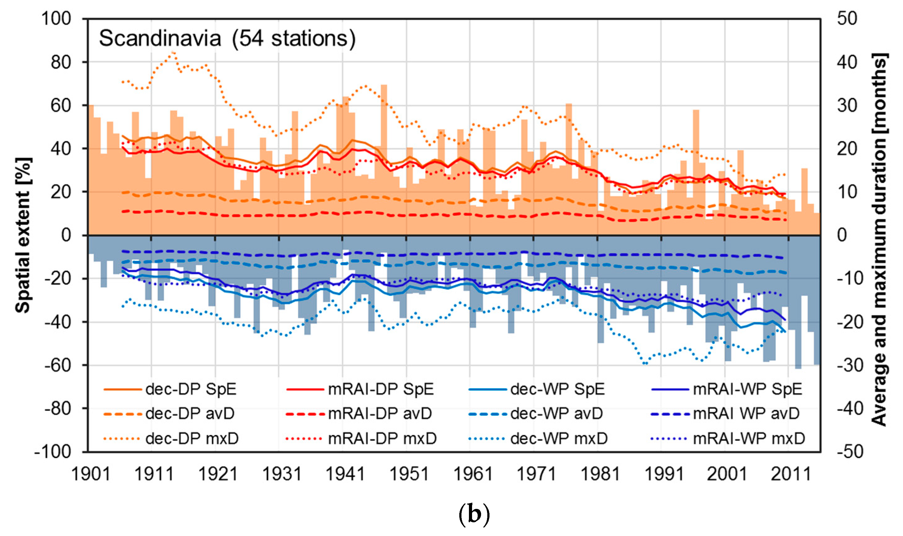
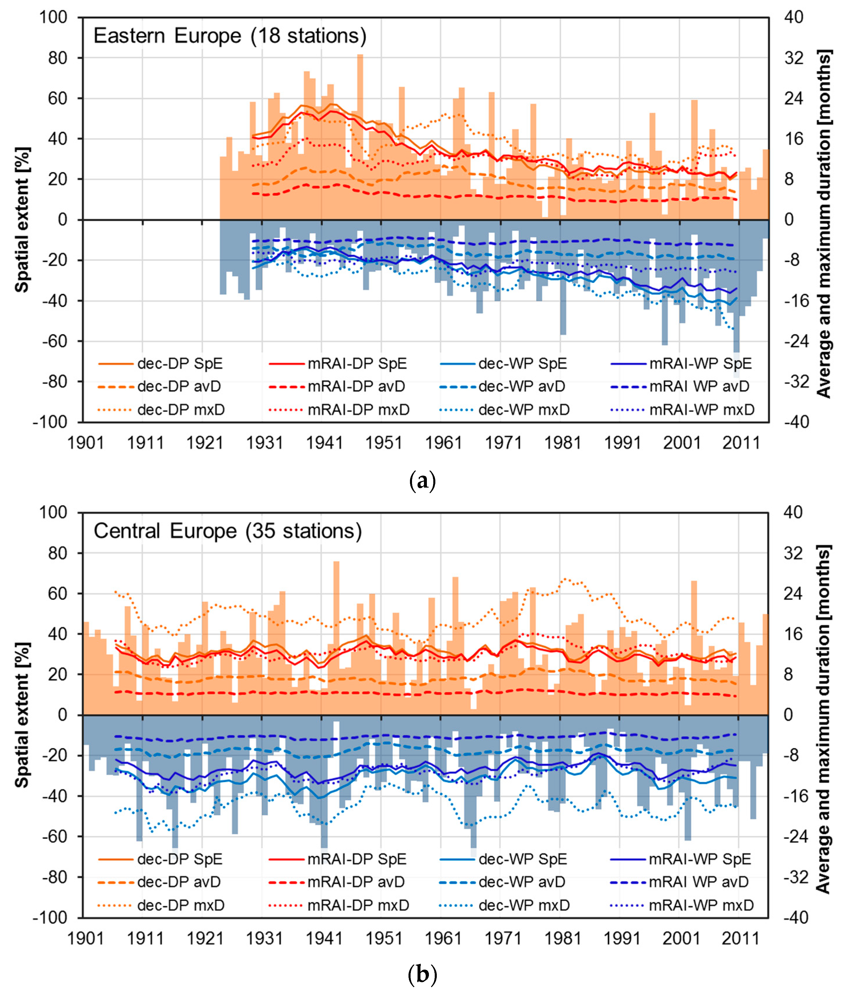
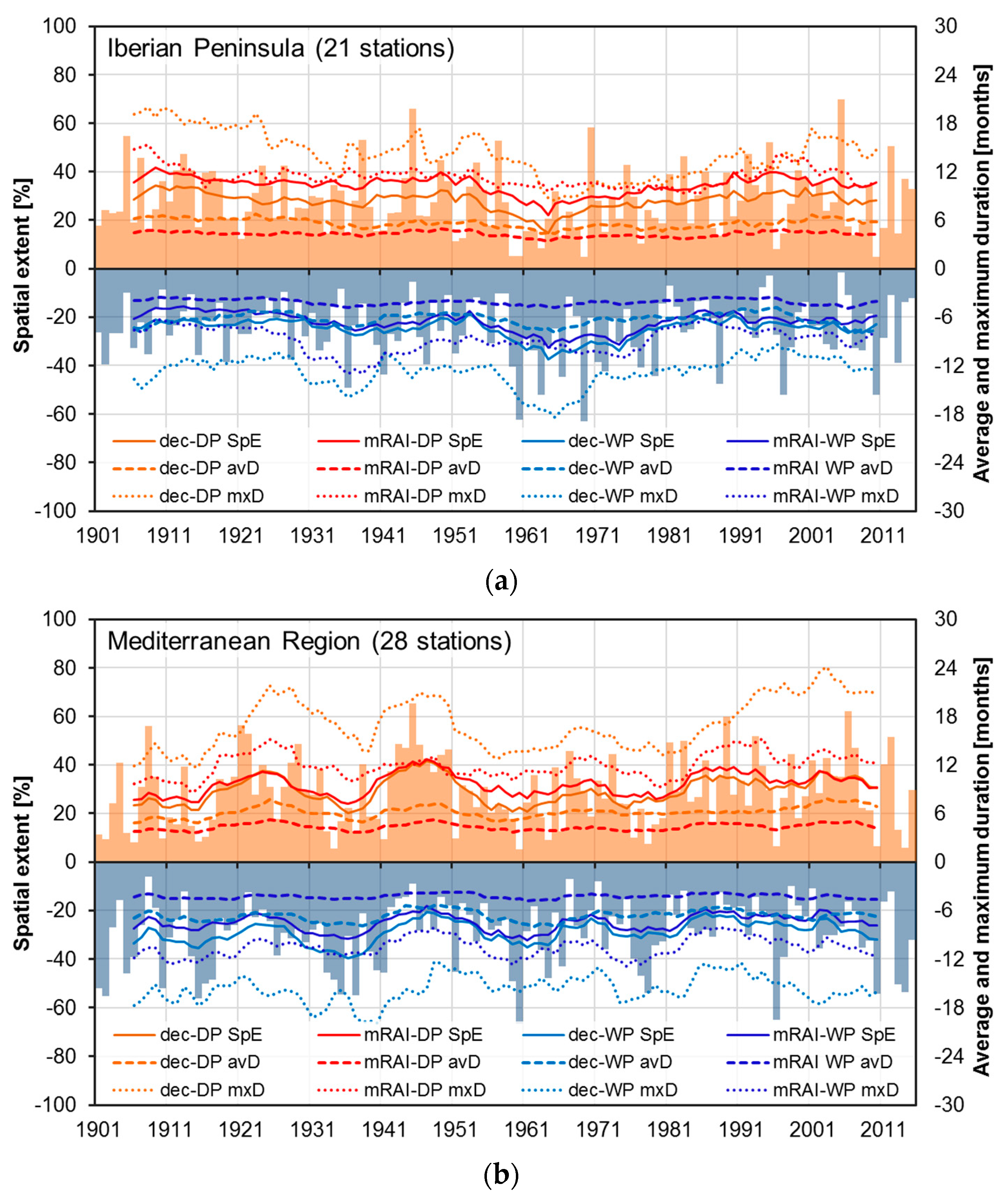
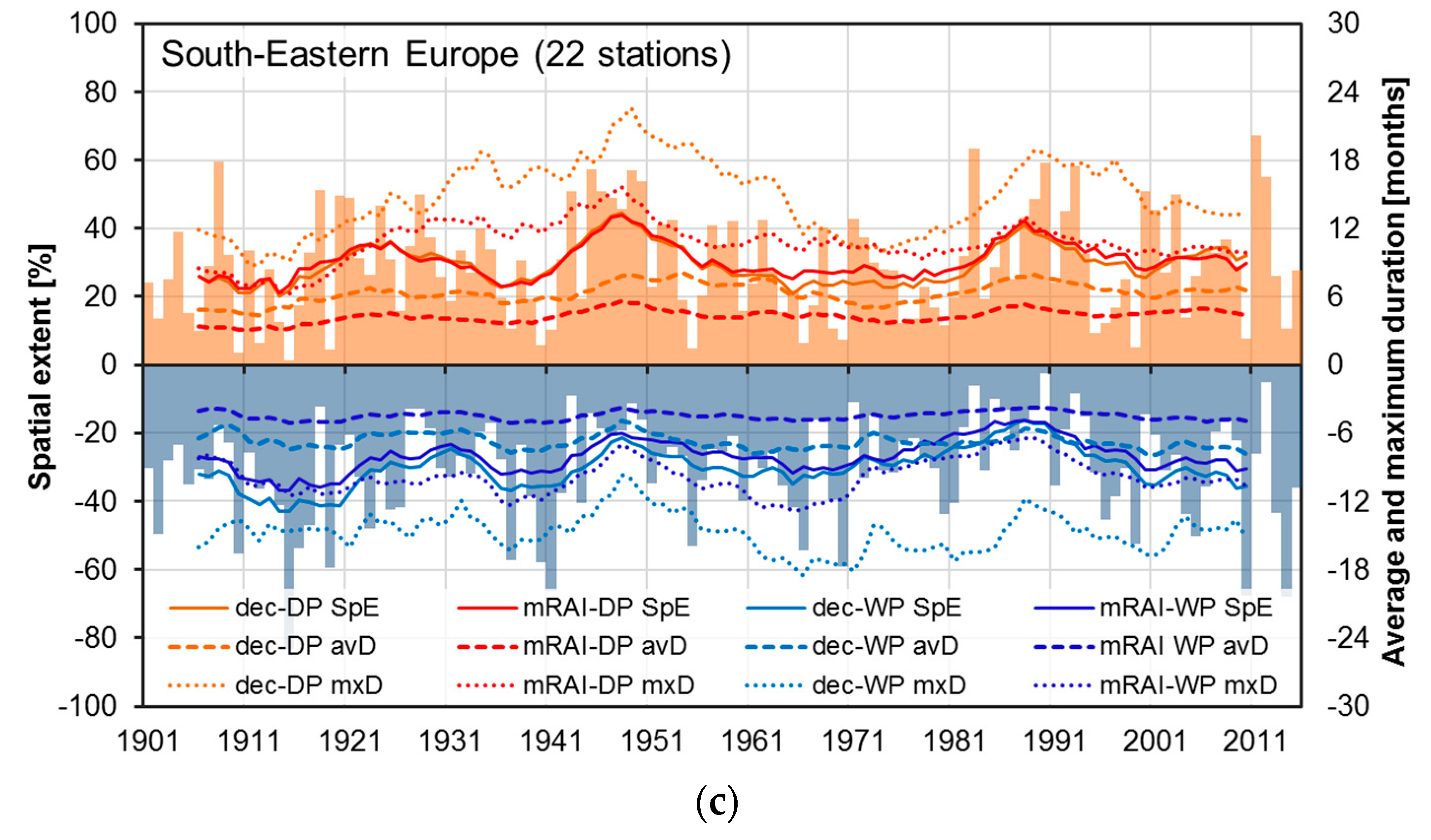
Regional perspective: The regional average of the spatial extent of decile dry periods within 1966–2015 ranges from 24% (EE: Eastern Europe) to 31% (CE: Central Europe), the one of decile wet periods varies between around 25% (IP: Iberian Peninsula) and 34% (SC: Scandinavia; Table 2). The maximum values of the regional spatial extent of dry periods peak at values close to 100% for almost all sub-regions (Table A1, Table A2, Table A3, Table A4, Table A5, Table A6, Table A7 and Table A8). This indicates reasonably homogeneous climatic conditions within the sub-regions. Just in region SC (Scandinavia) that encompasses the highest number of stations, the maximum spatial extent is a bit lower (91%/92% for decile/mRAI dry periods, and 78%/85% for decile/mRAI wet periods).
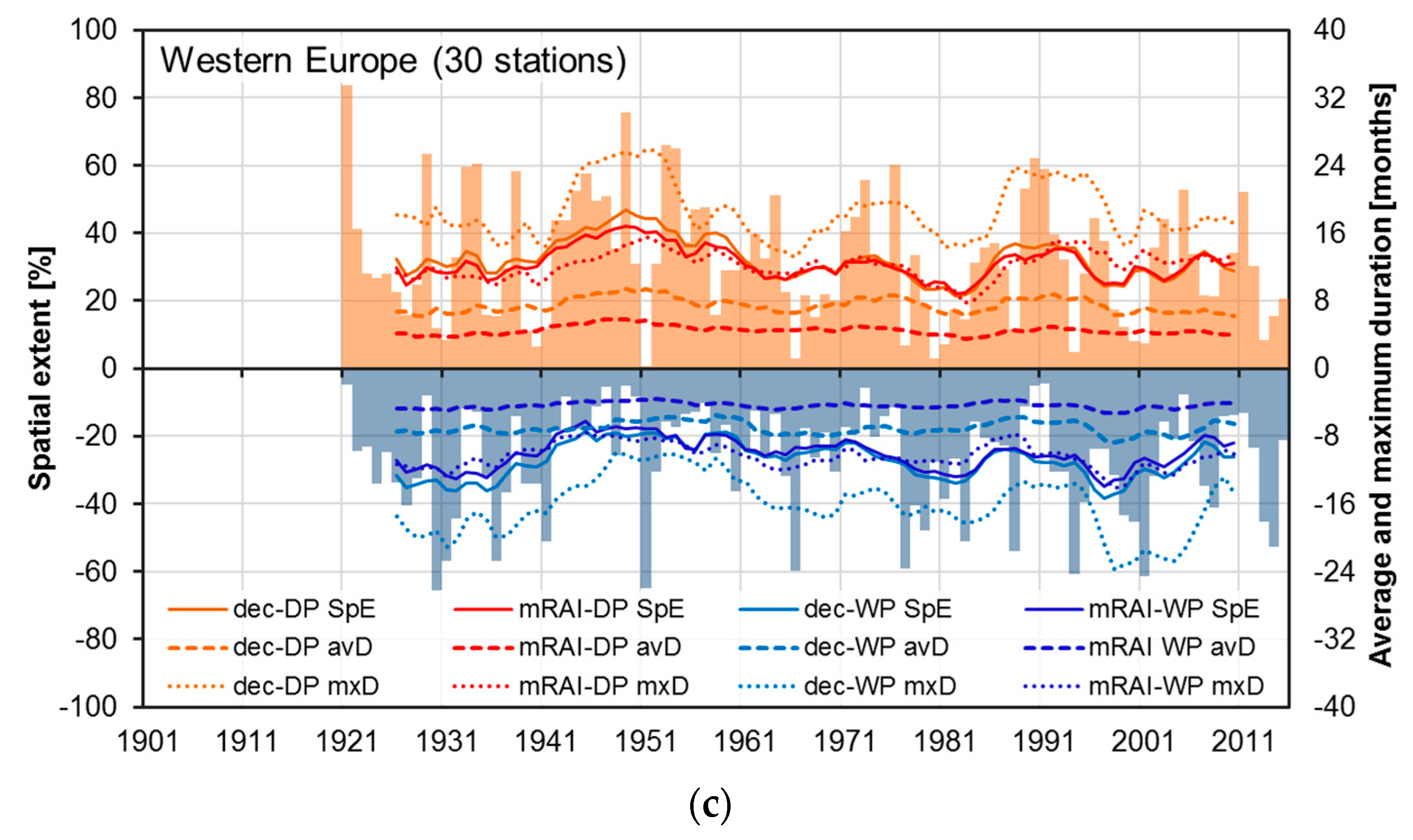
The regional TOP20 months with the highest spatial extent of dry and wet periods, respectively, as identified by mRAI and the deciles index are summarized in Appendix A (Table A1, Table A2, Table A3, Table A4, Table A5, Table A6, Table A7 and Table A8). For region BI (British Isles), most TOP20 dry period months were between the 1930s to the 1970s, while wet periods of high spatial extent frequently occurred in the 1950s and after 2000 (Table A1). The Scandinavian (SC) TOP20 spatial extent of dry periods most frequently occurred in the 1940s, while the majority of spatially particularly extended wet periods were observed after 2000 (Table A2). Eastern Europe (EE) shows frequent TOP20 months of spatially extended dry periods in the 1920s to 1950s (Table A3) and Central Europe (CE) in the 1940s and 1970s (Table A4). June to November 2003 is also a prominent dry period with a high spatial extent in region CE. In regions EE and CE, the TOP20 months of the spatial extent of wet periods are quite evenly distributed over the respective study period with slight peaks at the beginning of the 1980s for EE and in the 1910s and 1960s for CE. Many months with the highest spatial extent of dry periods over Western Europe (WE) belong to the 1920s, while no event has been identified since the 1980s, except for Feb 1992 (Table A5). Many of the TOP20 months of spatially extended wet periods in region WE occurred in the 1930s and 1970s. Months with a particularly high spatial extent of dry periods over the Iberian Peninsula (IP) occurred in the 1890s, 1940s, 1970s, and after 2000, while for wet periods the same is the case for the 1940s, 1960s, 1970s, and again after 2000 (Table A6). This example shows that a high spatial extent of dry and wet periods, respectively, can occur in short sequence within the same decade. The Mediterranean region (MR) has many very long time series and thus allows studying dry and wet periods for 1851–2015. A considerable proportion of the TOP20 months of spatial extent already occurred in the 1850s and 1860s for both wet and dry periods (Table A7). The 1940s and the years after 2000 were decades with many TOP20 months of the spatial extent of dry periods in South Eastern Europe (SE), while many months of the highest spatial extent of wet periods occurred in the 1910s and the 2010s (Table A8).
3.1.2. Duration and Frequency of Decile Periods
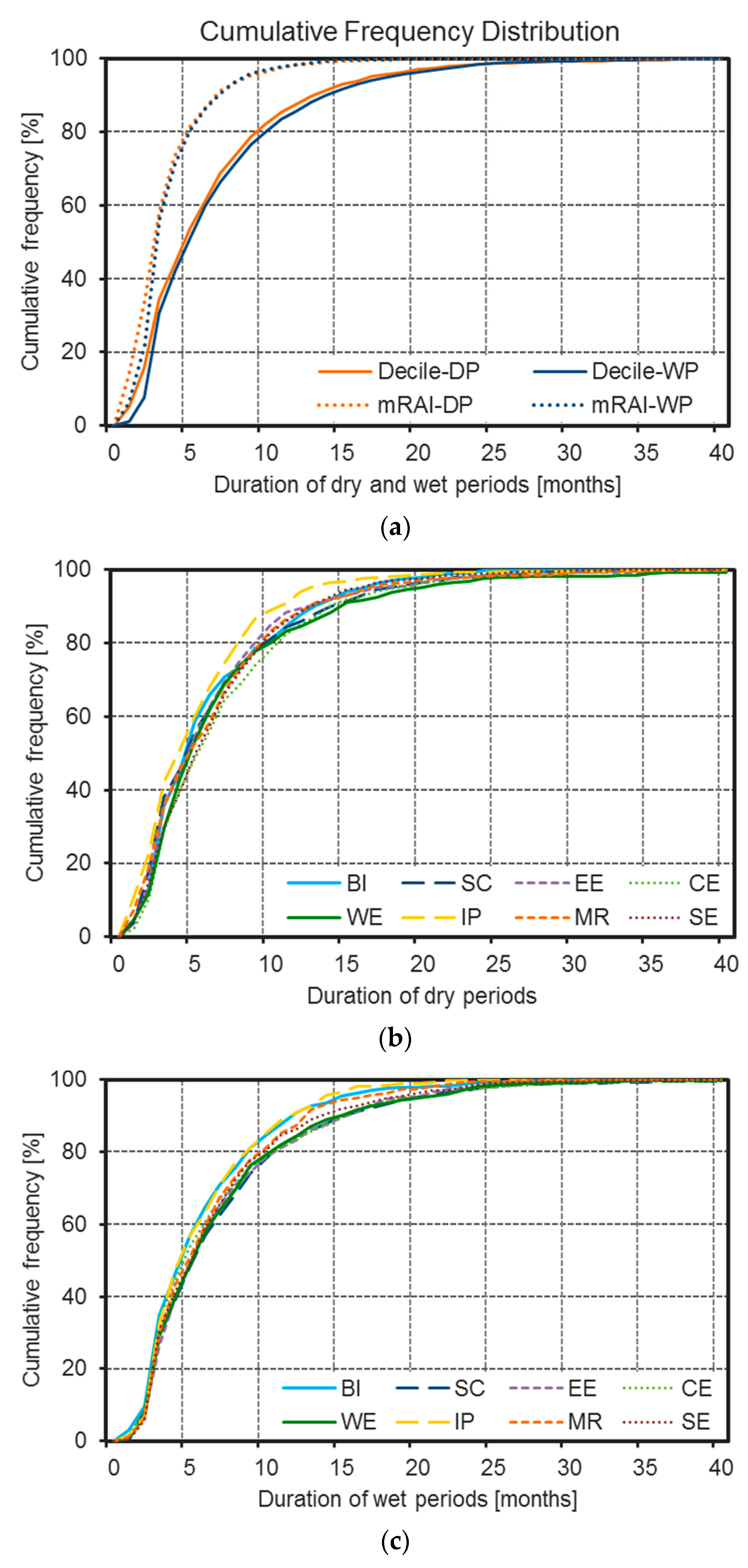
European perspective: An average decile dry period and wet period, respectively, persists about seven months and occurs about five times within ten years (for period 1966–2015; Table 2). The median duration is with about 5.5 months noticeably smaller than the arithmetic mean, indicating a right skewed distribution. Dry and wet periods identified using the mRAI are shorter (arithmetic average of approx. 4.5 months and median duration of 3.5 months) and occur more frequently (about 8/7 times within ten years for dry/wet periods) than those calculated using the deciles methodology.
The differences in the duration and frequency of dry and wet periods as defined by the deciles and the mRAI index, respectively, are further illustrated by the display of cumulative frequency distributions in Figure 3a. Comparing the duration of dry and wet periods for one index shows only slight differences in the cumulative frequency distribution. About 50% of the decile dry and wet periods have a duration of up to 5 months, while 80% last up to 10 months. In comparison about 80% of the mRAI dry and wet periods last up to 5 months. Just for very short durations of 1 to 2 months a distinct difference is visible between dry and wet periods. Dry periods—independent from the index used within this study—more often show shorter durations compared to wet periods.
The maximum duration of decile dry and wet periods is on average 23 months (for period 1966–2015), while using the mRAI-definition leads to shorter maximum durations of 15 months for dry and 14 months for wet periods. Some stations show much longer dry and wet periods of more than 60/30 months duration based on the decile/mRAI definition, with dry periods tending to show slightly larger maxima than wet periods.
Regional perspective: The sub-regional decile dry period duration for period 1966–2015 averages between 5.7 months in region IP and 7.5 months in region CE, while the average duration of mRAI dry periods is between 4.1 months in region BI and 4.6 months in region SE. The frequency of decile dry periods ranges from 4.6 events per ten years in the regions EE and WE to 6.0 events in region IP. The shorter duration of mRAI dry periods as compared to decile dry periods results in a higher frequency ranging from 7.5 events per ten years in region EE to 9.5 events in region IP. Decile wet periods have an average duration between 6.2 months in region IP and 7.8 months in region SC for the study period 1966–2015.
The regional range of average decile wet period frequency in events per ten years is between 4.7 (region WE) and 5.7 (region BI). Again, mRAI wet periods are shorter and more frequent as compared to those obtained with the decile definition. Their duration ranges from 4.2 months in the regions BI and IP to 4.8 months in region WE, while their frequency is between 6.6 (region IP) and 8.2 (region BI) events per ten years. Generally, longer mean durations are connected with lower frequencies. In principle, the same number of events per 10 years is to be expected within all regions, due to the distribution dependent threshold used for the index definition. Variations are explained by the fact that periods are considered, not separate events. An individual dry and wet period, respectively, can encompass several potential starting points for a new event. Thus, the total number of possible dry or wet periods decreases.
The sub-regional differences in the cumulative frequency distributions of dry and wet periods, respectively, are comparatively small (Figure 3b,c). Nonetheless, there are some regions that consistently tend towards shorter (IP; yellow lines in Figure 3b,c) or longer (CE and WE; light and dark green line in Figure 3b,c) dry and wet period durations. The generally small regional differences are explained by the large overlap of the study period displayed in Figure 3 (1966–2015) with the base period (1951–2000) used for calculating the statistics that form the basis for the index definition. The differences in the cumulative frequency distribution between the two indices are much more pronounced with decile periods tending to longer durations of dry as well as wet periods as compared to the mRAI-periods (Figure 3a).
3.1.3. Magnitude of Dry and Wet Conditions
The three driest (2003, 1953, and 1945) and wettest years (2010, 1960, and 1966) across Europe as indicated by the mRAI are displayed in Table 4. Additionally, Table 4 shows the wettest and driest seasons and half years. In most cases the average anomaly over the 220 stations on the seasonal scale is larger for the dry as compared to the wet events. The results for the eight sub-regions can be found in Appendix B (Table A9). Here, the regionally averaged anomalies reach considerably higher values (up to > ±2) than for the entire study area, as the climatic conditions within the sub-regions are more homogeneous. The driest year across the entirety of Europe, 2003, has been particularly dry in Central Europe (CE), while the second driest year was also the second driest in Western Europe (WE; after 1921). The wettest year over entire Europe, 2010, had its center over Eastern Europe (EE). The second wettest year averaged over all 220 stations, 1960, was particularly wet in the South-Western part of Europe (wettest in region IP: (Iberian Peninsula), second wettest in region WE (Western Europe), and third wettest in regions BI (British Isles) and MR (Mediterranean Region). Particularly wet over Central Europe (CE; second wettest) has been the third wettest year on the European scale, 1966.
3.2. Long-Term Changes
3.2.1. Precipitation Trends
Changes in spatial extent, duration, and frequency of decile and mRAI wet and dry periods, respectively, are probably related to general precipitation trends, as their calculation is based on monthly precipitation totals. Therefore, we first address the observed trends in precipitation anomalies, as indicated by the mRAI. The precipitation trends are then compared to changes in the frequency of more extreme precipitation conditions (severely wet and dry, respectively) as well as changes in the spatial extent and the duration of decile and mRAI periods.
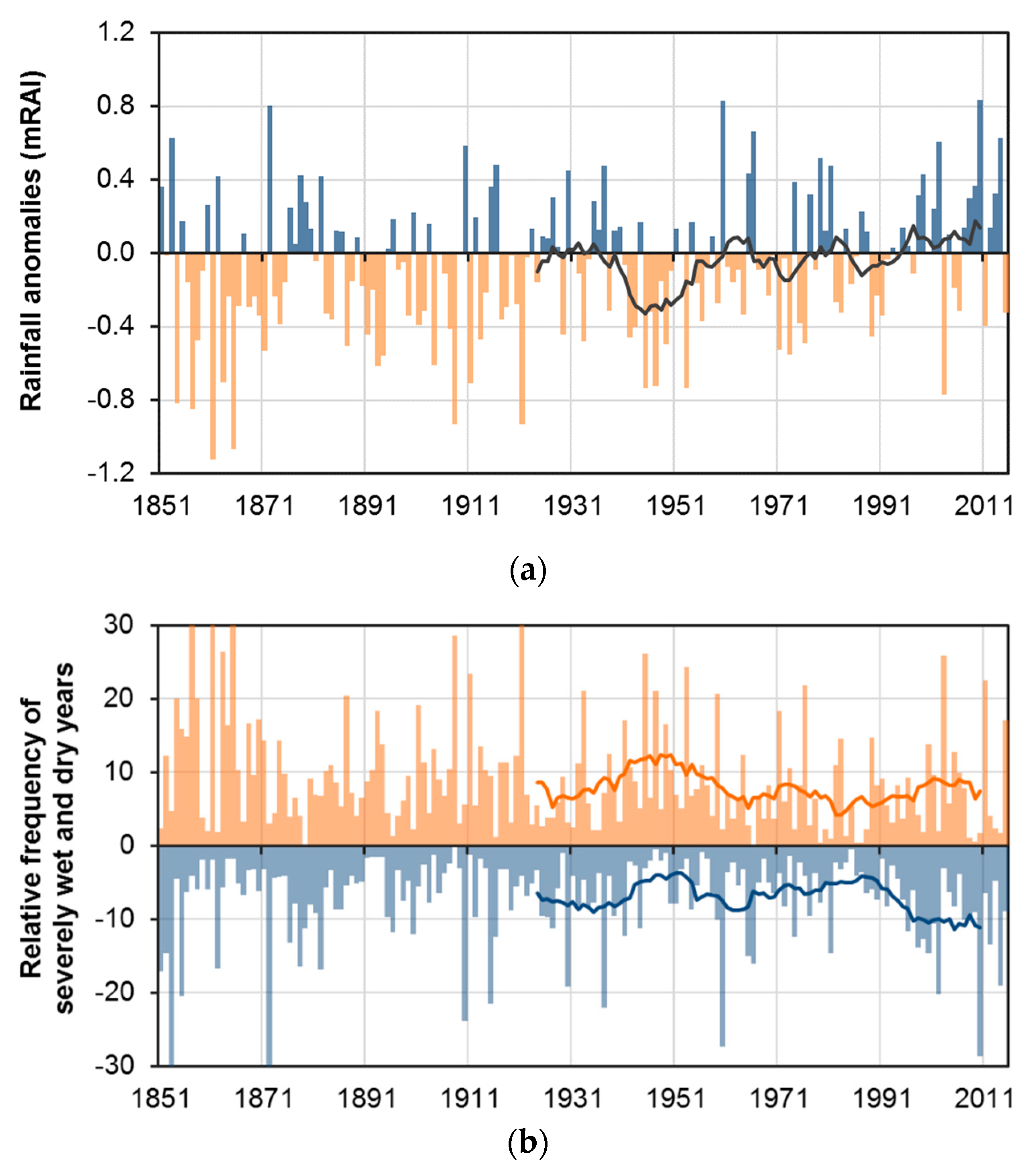
For the entire study area, a positive linear trend has been computed for period 1901–2015 as well as for period 1951–2015 (Table 5), with the highest annual precipitation increases in the regions BI (British Isles), SC (Scandinavia), and EE (Eastern Europe) and slight decreases in regions MR (Mediterranean region), SE (South Eastern Europe), and for period 1951–2015, also IP (Iberian Peninsula). Figure 4a illustrates the high temporal variability of the mRAI values at the timescale of 12 months (values for December). Frequent negative anomalies—indicating dry conditions—occurred in the 1940s. Since the 1990s, the precipitation anomalies at the European scale are predominantly positive, leading to the positive linear precipitation trend indicated in Table 5.
The analysis of changes in the frequency of severely wet (mRAI > 1.5) and severely dry (mRAI < −1.5) events shows similarities to the trends of average precipitation totals (Table 5 and Figure 4b). During most of the time, the frequency of severely dry and wet years is negatively correlated, leading to opposite trends (please note that for reasons of illustration wet period results are displayed as negative values in Figure 4b resulting in a seemingly positive correlation with the frequency of severely dry events). Just at the end of the study period (starting in the 1980s) a decoupling of the frequency of severely dry and wet years occurs. The general precipitation increase during these decades is connected with a distinct increase in severely wet events, while the frequency of severely dry years slightly increases at the same time. Particularly strong decreases in the frequency of severely dry events are seen in region BI for all seasons.
At the seasonal scale, there is also a strong (multi)decadal variability (Figure 5). All seasons show negative European precipitation anomalies during the 1940s until the beginning of the 1950s, which explains the strong negative precipitation anomaly during these decades in the annual dataset. During the other times, there are more differences between the individual seasons, with some showing positive and other negative anomalies. Positive summer anomalies occurred in the 1920s, the 1950s, and during the last years of the study period.
The precipitation anomaly time series for the eight sub-regions are displayed and described in Appendix C (Figure A1 and Figure A2). These illustrations also include information on the temporal evolution of severely dry and wet conditions within the sub-regions.
3.2.2. Changes in Spatial Extent
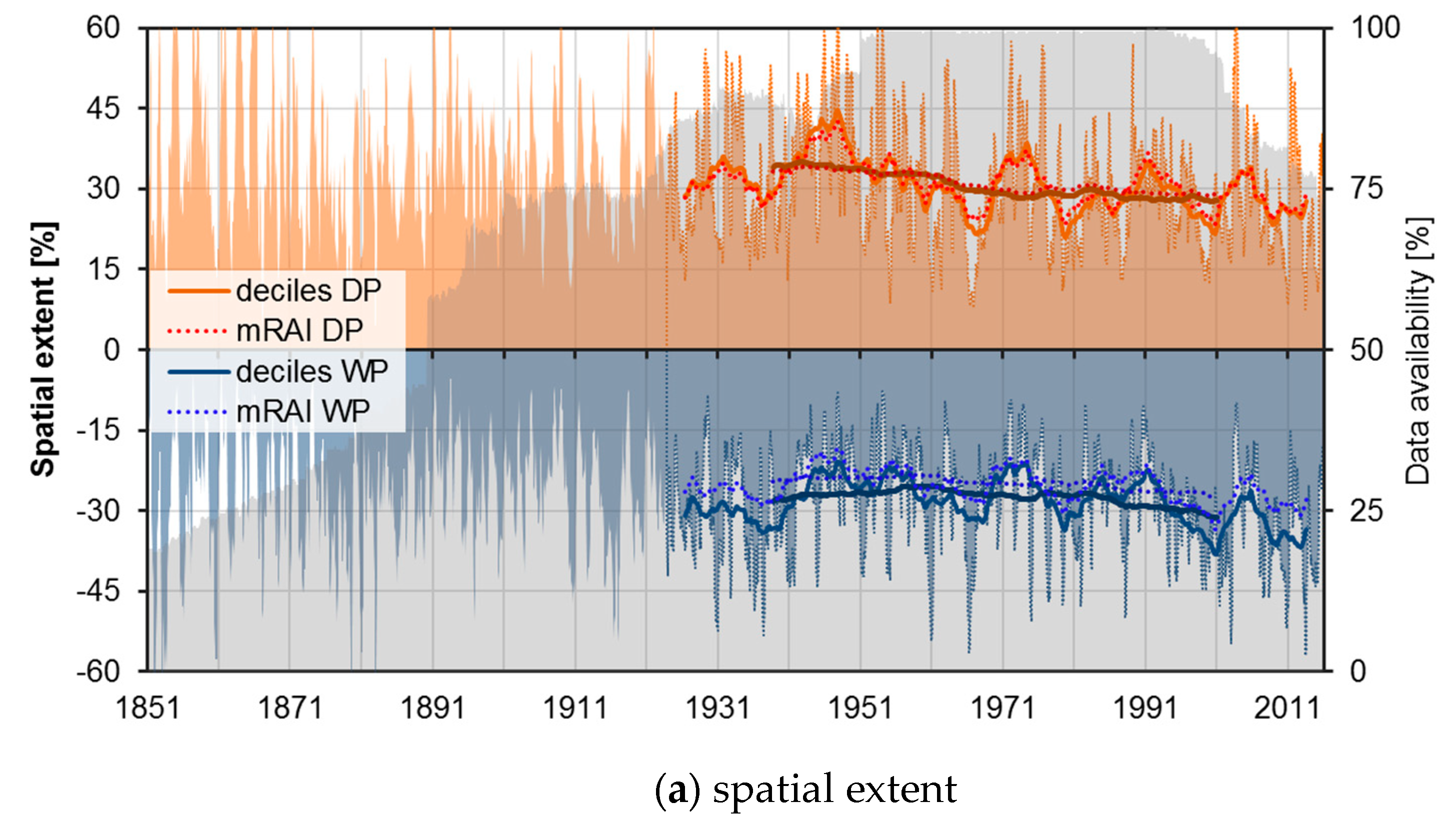
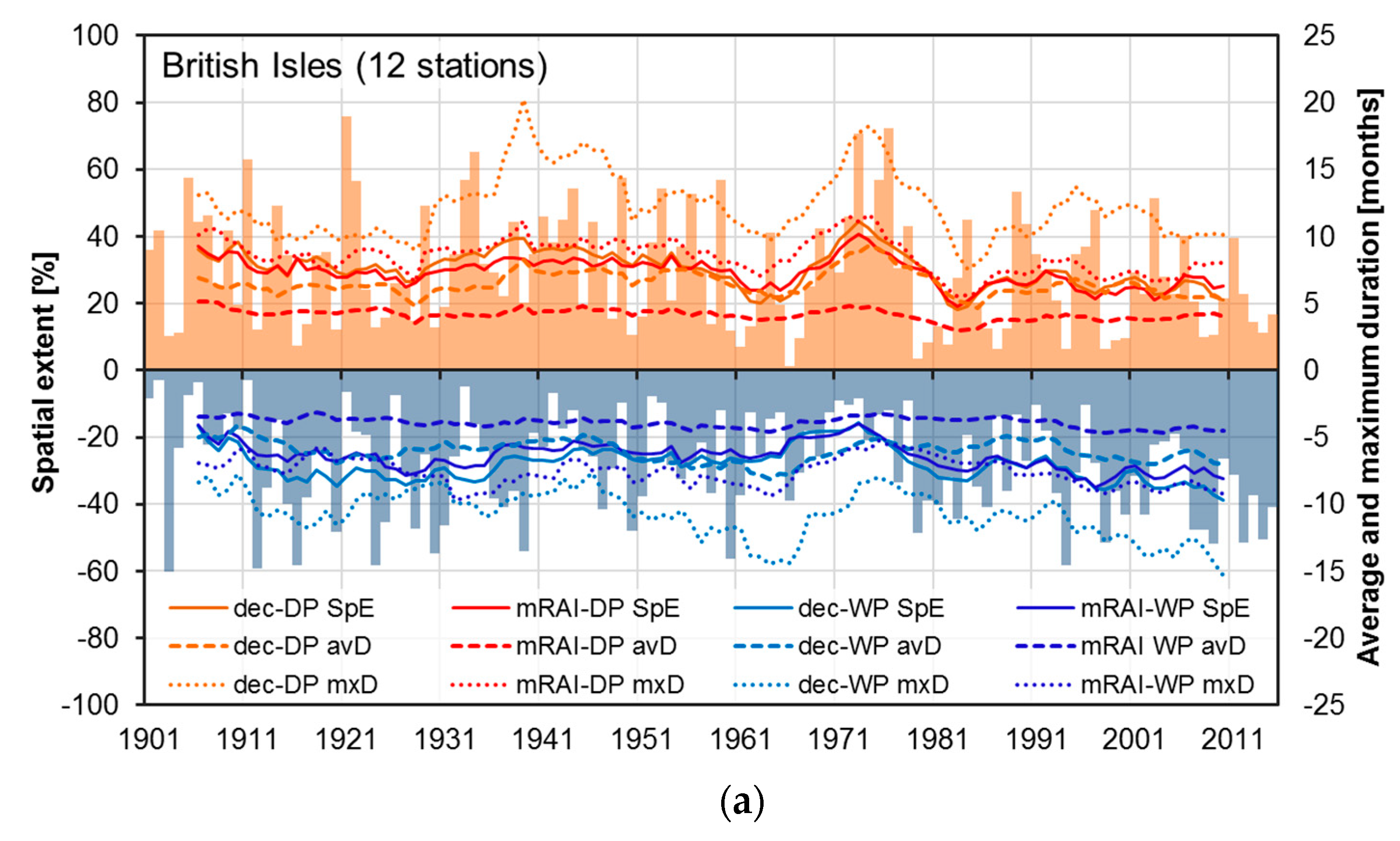
As shown in Figure 6a, the spatial extent of meteorological drought conditions indicated by the deciles index and the mRAI has decreased in Europe since 1924 with considerable (multi)decadal variability, while the one of wet periods increased (please note that for wet periods negative values are displayed in Figure 6, and thus, the increasing spatial extent of wet periods refers to increasingly negative values). Table 6 lists the computed relative linear trends for the spatial extent of dry and wet periods in Europe and its sub-regions. The trends for the two studied indices are well comparable in most cases, despite the differences in the absolute values of the index values.
Similar to that already described in Section 3.2.1 for the precipitation changes, the trend towards wetter conditions—to be more specific, the tendency towards a higher spatial extent of wet periods and a lower spatial extent of dry periods—is particularly pronounced in region SC (Table 6). Regions BI, EE, and WE also show distinct changes towards wetter conditions. Region CE shows a quite mixed trend picture with some positive and some negative trends, but most trends are comparatively small and not robust against the background of the large spatial and temporal variability of dry and wet periods. Region MR shows the most consistent development towards drier conditions with an increasing spatial extent of dry periods and a decreasing spatial extent of wet periods for both study periods. Regions IP and SE show also trends towards drier conditions that are particularly pronounced in region IP for period 1951–2015.
3.2.3. Trends of Decile Period Duration and Frequency
The decrease in the spatial extent of dry periods (Figure 6a) is connected with a decrease in average and maximum duration (Figure 6b,c) as well as in the frequency of dry periods over Europe (Table 6). The opposite is true for wet periods that show increasing durations and frequencies (Figure 6 and Table 6). Again, region SC shows the most pronounced trends towards wetter conditions that are also most consistent over the two study periods and indices, respectively. Regions BI and EE also show quite pronounced trends towards shorter dry and longer wet periods, while the trends for region WE are a bit smaller, but still point into the same direction. For region CE, a slight increase in the frequency of dry as well as wet periods is visible in both study periods, while the duration of dry and wet periods tends towards decreasing trends, particularly for the longer study period 1901–2015. The slightly decreasing precipitation totals in the southern regions IP, MR, and SE are connected with an increase in the duration and frequency of dry periods, while wet periods occur less frequently.
The trends computed by linear regression are strongly dependent from distinct anomalies at the beginning and the end of the respective study period. Furthermore, as periods that last several months to years are studied here, the event and its duration have to be assigned to a specific date for purposes of generating time series and analyzing their trends. We decided to assign the duration and the count of a specific event to the last month of the period. Thus, there might be some shift between time series of average and maximum duration as well as event frequency in comparison to the percentage of stations that are currently affected by a dry or wet period, respectively. These differences may also considerably influence the trend magnitude. In order to allow for a better assessment of the robustness of the computed trends, we present the sub-regional time series of spatial extent as well as average and maximum duration in Appendix D (Figure A3, Figure A4 and Figure A5).
4. Discussion
Spatial extent and duration of dry periods have decreased noticeably over Europe, particularly its northern sub-regions, while wet periods showed slight increases. Those trends agree with positive trends in precipitation extremes over the northern mid-latitudes [72,73]. Some of the trends intensified in the second half of the 20th century, in accordance with the temperature and precipitation trends that also show stronger signals in the most recent decades [54,70]. The described trends towards wetter conditions in northern Europe yet drier ones in southern Europe match recent studies on observational data [58,89,90,91] and are projected to continue through the 21st century [57]. However, drought trends for central Europe are more diverse and often linked to temperature increases [34,92]. Although, several drought summers were observed at the beginning of the 21st century in Central Europe such as the summer of 2003 [93], the period 2011/2012 [94], the summer of 2015 [88,95], and the two-year drought of 2018/19 [96,97]. Summer drought in Central Europe is not a new phenomenon of the beginning of the 21st century. Already, the 1940s and the 1950s were very dry [77,78,79]. During the summer half year of 1947, Central Europe was hit by an extraordinary drought event with wide ranging socio-economic consequences [98] and the drought events of the early 1950s covered half of Europe at the timescale of 12 months [35].
The presented trends in the spatial extent as well as the duration and frequency of dry and wet periods, respectively, are generally in line with the trends in average precipitation totals. Therefore, using the mRAI for the identification of dry and wet periods leads to widely comparable results to the deciles index for the spatial extent of dry and wet periods, while the average and maximum duration of such events is considerable shorter. This is related to the applied stopping rule, which refers to precipitation totals dipping under median conditions in case of mRAI and under the 30th percentile in case of the decile index. Another stopping rule for the mRAI dry/wet periods, namely mRAI values of 0.5/−0.5 instead of zero, was tested in order to evaluate the sensitivity of the indices and connected trends to the generally arbitrary thresholds of climate indices. These analyses (not presented here) showed considerably longer mRAI period durations that were even longer than the decile periods and led to a strong increase in the average spatial extent of dry and wet periods, respectively. Generally, the present analyses show that both indices are useful for studying long-lasting dry and wet periods over the different climate regimes of Europe and deliver comparable results with respect to the timing of such events and their long-term trends.
Advantages of the two indices used in this study include their straightforward computation and that they need neither specific tools or programs nor excessive data (e.g., climate, soil, or land use). Thus, they can be easily applied in many different contexts and regions. The indices do not make complex assumptions on the statistical properties of the data and still deliver comparable results to studies applying indices that are more complex. By purely focusing on precipitation, we can analyze a longer period, as would be possible if more variables are to be included in the index calculation. This is particularly important against the background of the large temporal variability of precipitation. It allows putting the trends observed in recent decades in a long-term perspective. The deciles indicator and the mRAI may be used in drought studies and at least the mRAI may be easily computed at different timescales to address the different drought types (meteorological, agricultural, hydrological, and socio-economic drought).
The clustered occurrence of long-lasting dry or wet periods over time indicates a relation of decile and mRAI periods, respectively, to long-term variations in atmospheric and/or oceanic circulation. Thus, also the observed changes in dry and wet period coverage may be due to variations in the strength and position of atmospheric circulation patterns, which distinctively effect precipitation characteristics [99]. Mapping composite anomalies of, e.g., precipitable water and 850 hPa geopotential height or 300 hPa geopotential height and isotachs, could help to explain some of the regional precipitation (or drought) signatures described in the manuscript. The same continental atmospheric pattern affects the individual European sub-regions differently, for instance triggering wetter conditions in one, but dryer conditions in another part of Europe, which may explain the regionally different trend behavior of the characteristics of wet and dry periods. This calls for a more precise and targeted data analysis of connection between the identified spatial and temporal pattern of dry and wet periods and indices of atmospheric circulation for the individual sub-regions. Haslinger et al. [100], e.g., studied the drivers of meteorological drought in the European Greater Alpine Region and found that the dry springs of the 1940s developed under a persistent positive pressure anomaly across Western and Central Europe, triggered by positive sea surface temperatures in the western subtropical Atlantic. Further analysis on the relation between the characteristics and trends of dry and wet periods and indices of atmospheric circulation are worthwhile, although links between the atmospheric circulation and dry and wet period occurrence cannot simply be reduced to cause–effect relationships. The great number of influential variables and interactions in meteorological and climatological studies always hampers straightforward conclusions.
The increased spatial extent of wet periods over Europe might indicate an increasing impact of synoptic-scale cyclones and their corresponding frontal systems. On the other hand, the negative trend of the spatial extent and duration of long-lasting dry periods over Europe may have been triggered by more frequent interruptions of such periods by phases of above average precipitation (e.g., more frequent convective precipitation). To confirm this, additional analyses based on daily data are necessary. Some studies that used drought indices in monthly and daily resolution and additionally studied heavy precipitation indices found simultaneous increases in the frequency of drought and heavy precipitation events over parts of Europe (i.e., Central Europe; [88,92]).
Such precipitation–based drought indices such as the two applied here or the widely used Standardized Precipitation Index (SPI) are based on the assumption that drought is mainly influenced by the variability of precipitation and that other drought controlling factors (temperature, relative air moisture, wind speed, radiation, evaporation) do not change over time. Although the variability of precipitation is generally much larger than the one of other climatic variables, the second important assumption on the temporal stationarity of these variables is violated in a warming climate. Rising temperatures and the related increase in water pressure deficit may strongly increase the severity of droughts independent of changes in the precipitation regime. This is particularly true for the warm part of the year where the rising evaporative demand [101] potentially increases drought frequency and severity [61,102]. Combining heat and drought is important because of the more severe impacts compared to individual extremes in either of the components [103]. Thus, a drought index incorporating temperature information, such as the SPEI or the PDSI, can give additional valuable insights and support the assessment of drought severity in a changing climate [43,61].The recent drought events in Europe were often accompanied by extremely high temperatures or long lasting heatwaves [88,93,96,104,105,106]. Thus, further studies on the regional changes in drought should incorporate more complex drought indices that also account for the effects of increasing temperature extremes.
5. Conclusions
The decile indicator has been shown to be a simple but powerful tool to visualize the characteristics of long-lasting dry and wet periods in Europe. Using the mRAI delivers comparable results and additional information of the intensity of drought conditions or the degree of wetness. The comparison of the results delivered by those straightforward indices with the scientific literature that bases their conclusions on more complex and computationally intensive indices shows that the mRAI and the deciles index are suitable to study the variability and changes of dry and wet periods over Europe. Thereby, the classification of Europe into climatologically homogeneous sub-regions is helpful to interpret the regionally variable characteristics and trends.
The approach of studying dry and wet periods based on 3-month precipitation totals results in event durations of several months to years. Decile and mRAI periods start under moderate extreme conditions and linger until precipitation conditions leave the “normal range” towards the opposite extreme. A mere return to normal conditions is often insufficient to refill depleted aquifers or to equalize high groundwater levels, and thus, such dry periods may last even longer in specific water reservoirs than indicated.
Strong inter-decadal variations are described in the spatial extent, average and maximum event duration, and frequency of long-lasting dry and wet periods for Europe and the eight studied sub-regions. Nonetheless, some distinct long-term trends emerged. Spatial extent and duration of wet periods show positive trends over Europe. In contrast, dry periods show decreases, particularly in the northern sub-regions, which agrees to positive trends in precipitation averages and extremes over the northern mid-latitudes. The simultaneous increase of the frequency severely dry and severely wet years over Europe since the 1980s indicates that precipitation is getting more extreme at both sides of the rainfall distribution.
The observed decreases in spatial extent and duration of decile dry periods do not necessarily imply a decreasing drought risk. Droughts are defined on multiple timescales and also depend on climate variables other than precipitation, namely temperature, radiation, wind, and humidity. Including information on temperature in the identification of dry periods in order to assess the evaporative demand would be a next step in evaluating the practical relevance of the found precipitation variability and trends for hydrological and agricultural systems, natural ecosystems, and human economic activities.
Funding
The author Stephanie Hänsel was supported by the Mary-Hegeler post-doctoral scholarship of TU Bergakademie Freiberg.
Acknowledgments
I acknowledge the data providers in the ECA&D project. Klein Tank, A.M.G., and Coauthors, 2002. Daily dataset of 20th century surface air temperature and precipitation series for the European Climate Assessment. Int. J. of Climatol., 22, 1441–1453. Data and metadata are available at http://www.ecad.eu. The author wishes to thank Wiebke Miketta, Anne Schucknecht, and Andreas Hoy for their helpful comments and suggestions on an earlier version of this manuscript. Many thanks also to four anonymous reviewers for their valuable feedback that helped refining the manuscript.
Conflicts of Interest
The author declares no conflict of interest.
Appendix A
In Addition to the European perspective given in Table 3, an overview on the 20 months with the highest spatial extent of dry and wet periods as identified by the deciles index and the mRAI, are given for the eight sub-regions in Table A1, Table A2, Table A3, Table A4, Table A5, Table A6, Table A7 and Table A8. The dates are given in chronological order with months belonging to the same period printed in the same line. The lists may contain more than 20 months in case of the same percentage occurring several times.

Table A1.
Sub-region British Isles—overview on the TOP20 months with the highest spatial extent of dry and wet periods within the study period 1901–2015.
Table A1.
Sub-region British Isles—overview on the TOP20 months with the highest spatial extent of dry and wet periods within the study period 1901–2015.
| Date | % | Date | % | Date | % | Date | % |
|---|---|---|---|---|---|---|---|
| mRAI | Deciles | mRAI | Deciles | ||||
| Dry Periods | Wet Periods | ||||||
| Jan–Feb 1905 | 100 | Aug 1912 | 100 | Aug 1912 | 100 | ||
| Apr–Jul 1911 | 100 | Jul–Oct 1924 | 100 | Jul–Nov 1924 | 100 | ||
| Jan 1914 | 100 | Jan 1930 | 100 | ||||
| Jun, Nov 1921 | 100 | Jun–Jul, Nov–Dec 1921; Jan 1922 | 100 | Jun–Aug 1931 | 92–100 | ||
| Jan 1923 | 100 | Jan–Mar 1939 | 92 | ||||
| Apr 1932 | 92 | Sep 1950 | 100 | Sep–Nov 1950 | 92 | ||
| Jan–Mar 1934 | 92–100 | Feb–Mar 1934 | 100 | Dec 1954, Jan 1955 | 92 | ||
| Apr–Mai 1938 | 92 | Apr–May 1938 | 92 | Aug–Sep 1956 | 92 | Sep–Oct 1956 | 92 |
| Feb–May 1944 | 92–100 | Apr–May 1944 | 92 | May 1983 | 92 | ||
| May–Jun 1946 | 92 | Aug 1985 | 92 | ||||
| Oct 1947 | 92 | Oct–Dec 1947 | 92 | Feb–Mar 1994 | 92 | Feb–May 1994 | 92–100 |
| Mar–May 1953 | 100 | Mar-May 1953 | 92 | Nov–Dec 2000 | 92 | Nov 2000–Jan 01 | 92 |
| Oct–Dec 1955 | 92 | Nov–Dec 1955 | 92 | Jan 2010 | 92 | ||
| May–Jun 1956 | 92 | May–Jun 1956 | 100 | Feb–Mar 2014 | 92–100 | Feb–Mar 2014 | 92 |
| Oct 1959 | 92 | Oct 1959 | 92 | ||||
| Feb 1963 | 92 | ||||||
| Feb–Mar 1964 | 92 | Feb–Mar 1964 | 92 | ||||
| Sep–Nov 1972 | 100 | Oct 1972–Mar 73 | 92–100 | ||||
| Jul–Aug 1975 | 92 | ||||||
| Apr 1976 | 92 | Jan–Apr 1976 | 92 | ||||
| Aug–Sep 1983 | 92–100 | ||||||
| Apr 2003 | 92 | ||||||
Table A2.
Sub-region Scandinavia—overview on the TOP20 months with the highest spatial extent of dry and wet periods within the study period 1891–2015.
Table A2.
Sub-region Scandinavia—overview on the TOP20 months with the highest spatial extent of dry and wet periods within the study period 1891–2015.
| Date | % | Date | % | Date | % | Date | % |
|---|---|---|---|---|---|---|---|
| mRAI | Deciles | mRAI | Deciles | ||||
| Dry Periods | Wet Periods | ||||||
| Jan 1893 | 84 | Jan, Feb, May–Aug 1893 | 81–84 | Dec 1935 | 70 | Feb 1936 | 70 |
| Jan 1897 | 81 | Dec 1967 | 68 | ||||
| Sep 1901 | 82 | Sep–Nov 1901 | 82 | Apr–May 1989 | 74–76 | May 1989 | 72 |
| Dec 1908 | 84 | Mar 1990 | 74 | ||||
| Nov 1913 | 81 | Jul–Aug 1998 | 69–73 | ||||
| May 1918 | 84 | Sep–Oct 2001 | 72 | ||||
| Dec 1920 | 85 | Dec 1920–Jan 21 | 81–84 | Mar 2002 | 69 | ||
| Apr 1923 | 83 | Jan–Mar 2007 | 78–85 | Jan–Mar 2007 | 74–78 | ||
| Jan 1928 | 83 | Feb–Apr 2008 | 67–70 | Mar–Apr 2008 | 70 | ||
| Jun 1940 | 87 | Jun 1940 | 89 | Sep 2009 | 67 | ||
| May–Jul 1941 | 89–93 | May–Jul 1941 | 83–91 | Aug–Oct 2011 | 67–72 | Sep–Oct 2011 | 70–71 |
| Jan, Mar, Apr 1942 | 81–87 | Apr 1942 | 81 | Jul, Sep, Nov 2012 | 69 | ||
| Mar 1947 | 90 | Mar 1947 | 85 | Jan–Mar, Jul 2015 | 67–80 | Mar, May–Aug 2015 | 69–77 |
| Aug 1955 | 81 | ||||||
| Mar 1972 | 81 | ||||||
| May 1974 | 90 | ||||||
| Oct 1976 | 83 | Nov 1976 | 81 | ||||
| Feb 1979 | 81 | ||||||
| Jan–Mar 1996 | 84–88 | ||||||
Table A3.
Sub-region Eastern Europe—overview on the TOP20 months with the highest spatial extent of dry and wet periods within the study period 1924–2015.
Table A3.
Sub-region Eastern Europe—overview on the TOP20 months with the highest spatial extent of dry and wet periods within the study period 1924–2015.
| Date | % | Date | % | Date | % | Date | % |
|---|---|---|---|---|---|---|---|
| mRAI | Deciles | mRAI | Deciles | ||||
| Dry Periods | Wet Periods | ||||||
| Jan 1925 | 91 | Jan 1925 | 91 | Nov 1923–Jan 24 | 100 | Nov 1923–Jan 24 | 89–100 |
| Feb–Apr 1928 | 91–100 | Apr 1928 | 91 | Nov 1930–Jan 31 | 82 | ||
| Mar 1929 | 91 | Feb–Apr 1929 | 91–100 | Oct 1932 | 82 | ||
| Jan–Apr 1932 | 91–100 | Mar–May 1932 | 91 | Jun–Aug 1949 | 82–91 | ||
| Jan–Apr 1933 | 91–100 | Jan–Mar 1933 | 91 | Oct–Dec 1952 | 83–100 | Nov–Dec 1952 | 83 |
| Jan–Mar 1934 | 91–100 | Jan–Apr 1934 | 91–100 | Aug–Sep 1960 | 83 | ||
| Feb 1935 | 100 | Nov–Dec 1974 | 94 | Nov–Dec 1974 | 94 | ||
| Jan–Feb 1946 | 91 | Dec 1980 | 89 | Dec 1980–Jan 1981 | 83 | ||
| Jun 1947 | 91 | Jan, May, Jun 1947 | 91–100 | Dec 1981–Jan 82 | 89–94 | Jan 1982 | 89,0 |
| Oct–Dec 1951 | 94–100 | Oct–Dec 1951 | 94–100 | May 1994 | 94 | May–Jun 1994 | 83–89 |
| Dec 1953, Jan–Mar 1954 | 94–100 | Jan–Apr 1954 | 94–100 | Mar–May 1995 | 83–89 | ||
| Mar 1972 | 94 | Jul, Sep–Oct 2010 | 87 | Dec 2009, May–Nov 2010, Jan–Feb 2011 | 80–87 | ||
| May 1974 | 94 | ||||||
| Aug 1992 | 94 | Aug 1992 | 94 | ||||
Table A4.
Sub-region Central Europe—overview on the TOP20 months with the highest spatial extent of dry and wet periods within the study period 1871–2015.
Table A4.
Sub-region Central Europe—overview on the TOP20 months with the highest spatial extent of dry and wet periods within the study period 1871–2015.
| Date | % | Date | % | Date | % | Date | % |
|---|---|---|---|---|---|---|---|
| mRAI | Deciles | mRAI | Deciles | ||||
| Dry Periods | Wet Periods | ||||||
| Aug 1893 | 83 | Nov 1882–Jan 83 | 72–80 | Jan 1883 | 84 | ||
| Nov 1911 | 84 | Nov–Dec 1911 | 87–90 | Feb–Mar 1900 | 70–77 | ||
| Jul 1934 | 87 | Jul 1934 | 87 | Sep–Oct 1910 | 74–77 | Oct–Nov 1910 | 77–81 |
| May 1943 | 86 | Mar 1915 | 71 | ||||
| Sep–Oct 1947 | 83–90 | Oct 1947 | 87 | Jul–Aug 1916, Jan–Feb 1917 | 77–71 | ||
| Feb 1949 | 93 | Feb 1949 | 93 | Feb–Mar 1923 | 74–77 | Feb–Apr 1923 | 77–87 |
| Apr–May 1953 | 91–97 | Feb–Mar 1941 | 71–81 | Feb, Mar, Aug, Oct 1941 | 77–81 | ||
| Mar–Apr 1963 | 86–89 | Jul–Sep 1965 | 80–91 | Jul–Sep 1965 | 80–86 | ||
| Mar–Apr 1971 | 83 | Feb–Mar 1972 | 86–89 | Jul–Aug 1966 | 71–74 | Jul–Oct, Dec 1966 | 80–89 |
| Jun–Aug 1976 | 83–86 | Jul–Oct 1976 | 91 | Jan 1982 | 71 | Feb 1982 | 80 |
| Jun–Nov 2003 | 83–91 | Jun–Dec 2003 | 86–91 | Apr 1988 | 80 | ||
| May 2011 | 83 | Dec 2002–Jan 03 | 77–80 | ||||
Table A5.
Sub-region Western Europe—overview on the TOP20 months with the highest spatial extent of dry and wet periods within the study period 1921–2015.
Table A5.
Sub-region Western Europe—overview on the TOP20 months with the highest spatial extent of dry and wet periods within the study period 1921–2015.
| Date | % | Date | % | Date | % | Date | % |
|---|---|---|---|---|---|---|---|
| mRAI | Deciles | mRAI | Deciles | ||||
| Dry Periods | Wet Periods | ||||||
| Apr–Jun, Dec 1921, Jan 1922 | 94–100 | Apr–Jul, Dec 1921, Jan 1922 | 88–94 | Jul–Dec 1930 | 81–88 | Jul 1930–Jan 31 | 84–88 |
| Mar-Apr 1929 | 92–96 | Mar–May 1929 | 92–96 | Jan–Feb 1936 | 81–89 | Mar 1936 | 81 |
| Apr, Jun 1938 | 92 | Apr, Jun 1938 | 88–92 | Apr–May 1937 | 82 | ||
| Feb–Apr, Aug 1949 | 90–97 | Feb 1949 | 93 | Aug 1951 | 80 | Jul–Aug 1951 | 80 |
| Mar–May 1953 | 100 | Mar–May 1953 | 90–97 | Dec 1952 | 80 | ||
| Jan–Feb 1954 | 90–97 | Oct–Dec 1960 | 83–87 | Nov 1960–Feb 61 | 80–83 | ||
| Jan 1957 | 90 | Jan–Feb 1966 | 80 | ||||
| Jul 1976 | 90 | Jul 1976 | 90 | Jul–Aug 1977 | 80 | Jul–Aug 1977 | 80 |
| Nov–Dec 1978 | 90–93 | Nov–Dec 1978 | 98 | May 1978 | 80 | ||
| Feb 1992 | 90 | Apr–May 1979 | 80–87 | May–Jun 1979 | 83 | ||
| Mar–May 1988 | 80–90 | Mar, May 1988 | 80–83 | ||||
| May 2001 | 83 | ||||||
Table A6.
Sub-region Iberian Peninsula—overview on the TOP20 months with the highest spatial extent of dry and wet periods within the study period 1894–2015.
Table A6.
Sub-region Iberian Peninsula—overview on the TOP20 months with the highest spatial extent of dry and wet periods within the study period 1894–2015.
| Date | % | Date | % | Date | % | Date | % |
|---|---|---|---|---|---|---|---|
| mRAI | Deciles | mRAI | Deciles | ||||
| Dry Periods | Wet Periods | ||||||
| Mar 1896 | 100 | Mar 1896 | 100 | May 1936 | 75 | May–Jun 1936 | 75–81 |
| Aug–Sep 1897 | 93 | May–Jun 1946 | 85 | May–Jun 1946 | 75–80 | ||
| Jun 1998 | 93 | Jul 1898 | 85 | Mar 1947 | 80 | Mar–May 1947 | 75–85 |
| Apr–May 1905 | 100 | Apr–May 1905 | 86 | Dec 1960 | 76 | Mar, May 1960 | 76 |
| Aug 1907 | 94 | Feb 1966 | 76 | ||||
| Jan 1913 | 93 | Apr 1968 | 75 | ||||
| Aug 1916 | 93 | Apr–May 1969 | 86 | May–Jun, Oct–Nov 1969, Jan 1970 | 76–86 | ||
| Feb 1923 | 93 | May–Jul 1971 | 80–90 | Jun–Aug 1971 | 76–90 | ||
| Aug 1924 | 94 | Aug 1924 | 94 | Oct 1976 | 76 | ||
| Mar 1944 | 94 | Feb–Mar 1979 | 76–81 | Feb–Mar 1979 | 76–81 | ||
| Apr–Jun 1945 | 95 | Apr–Jun 1945 | 85–90 | Jul–Aug 1988 | 86 | Jun–Jul 1988 | 86 |
| Oct–Nov 1970 | 90 | Aug 1997 | 75 | Aug, Nov, Dec 1997 | 75 | ||
| Feb 1975 | 100 | Feb 1975 | 86 | Jan–Feb 1998 | 75 | ||
| Oct 1978 | 95 | Jun–Jul 2008 | 75 | Jul 2008 | 80 | ||
| Oct 1985 | 95 | Mar 2010 | 75 | Mar 2010 | 75 | ||
| Feb–Mar 2000 | 95 | Apr–May 2013 | 75 | ||||
| May 2005 | 95 | Mar–Aug 2005 | 85–95 | ||||
| Feb–Mar 2012 | 85 | ||||||
Table A7.
Sub-region Mediterranean Region—overview on the TOP20 months with the highest spatial extent of dry and wet periods within the study period 1851–2015.
Table A7.
Sub-region Mediterranean Region—overview on the TOP20 months with the highest spatial extent of dry and wet periods within the study period 1851–2015.
| Date | % | Date | % | Date | % | Date | % |
|---|---|---|---|---|---|---|---|
| mRAI | Deciles | mRAI | Deciles | ||||
| Dry Periods | Wet Periods | ||||||
| Jan 1855 | 94 | Jul, Aug, Dec 1854, Jan 1855 | 88–94 | May–Aug 1853 | 88–100 | May–Aug 1853 | 94 |
| May–Jun 1857 | 94 | Jul–Oct 1855, Jan–Feb 1856 | 81–100 | Sep–Oct 1855, Jan–Feb 1856 | 87–100 | ||
| Oct–Dec 1861 | 89–95 | Oct–Dec 1961, Jan 1962 | 89 | May–Jun 1960 | 83–89 | Oct 1860 | 89 |
| Sep–Oct 1865, Feb–May 1866 | 90–100 | Feb, Mar, May 1866 | 90–100 | Feb–Apr 1863 | 83–89 | ||
| Nov 1894 | 92 | Dec 1868 | 90 | ||||
| Jan 1896 | 88 | Oct–Nov 1896 | 85 | Oct–Nov 1896, Jan–Feb 1897 | 85–89 | ||
| Nov 1928 | 89 | May 1916 | 82 | May 1916 | 86 | ||
| Jul–Nov 1945 | 93–100 | Jul–Nov 1945 | 93–96 | May 1935 | 86 | Mar–Jun 1935 | 86–89 |
| Dec 1985 | 89 | May–Jun 1960 | 86–90 | ||||
| Feb–Apr 1989 | 89–93 | Mar–Jun 1989 | 89–93 | May 1996 | 82 | ||
Table A8.
Sub-region South Eastern Europe—overview on the TOP20 months with the highest spatial extent of dry and wet periods within the study period 1881–2015.
Table A8.
Sub-region South Eastern Europe—overview on the TOP20 months with the highest spatial extent of dry and wet periods within the study period 1881–2015.
| Date | % | Date | % | Date | % | Date | % |
|---|---|---|---|---|---|---|---|
| mRAI | Deciles | mRAI | Deciles | ||||
| Dry Periods | Wet Periods | ||||||
| Dec 1890 | 82 | Dec 1880–Apr 81 | 80–90 | Apr 1881 | 91 | ||
| Nov 1907–Feb 08 | 87–93 | Feb–Apr 1895 | 83–92 | Feb–Mar 1895 | 91–92 | ||
| Sep 1917 | 93 | Nov 1917 | 86 | Mar 1900 | 85 | Mar–Apr 1900 | 92 |
| Jul–Aug 1945 | 95 | Jul–Sep 1945 | 82–91 | Mar, Apr, Nov, Dec 1915 | 79–86 | May–Jul 1915 | 93 |
| Sep 1946 | 91 | Aug–Sep 1946 | 82–91 | Feb–Apr 1917 | 86–93 | Feb–Apr 1917 | 93 |
| Sep 1952 | 91 | Apr 1944 | 82 | ||||
| Mar–Apr 1957 | 86 | Oct–Nov 1972 | 82–86 | ||||
| Apr–May 1983 | 82 | Feb 1996 | 82 | ||||
| Feb–Mar 1989 | 91–95 | Mar–Apr 1989 | 91 | Dec 1999 | 82 | ||
| Jan 1993 | 91 | Feb 1993 | 82 | Aug 2010 | 88 | Sep 2010–Feb 11 | 87–100 |
| Sep–Oct 2000 | 91 | Sep–Oct 2000 | 82 | Nov–Dec 2014 | 80 | Jul, Sep–Dec 2014 | 87–93 |
| Jul–Sep 2003 | 90–100 | Jul–Sep 2003 | 90–100 | ||||
| Jun, Nov, Dec 2011; Jan 2012 | 87–93 | Jun, Oct–Dec 2011; Jan 2012 | 87–93 | ||||
Appendix B
Additionally to the three driest and wettest years and seasons on the European scale presented in Table 4, the results at the sub-regional scale are presented in the following Table A9.
Table A9.
Overview over the three driest and wettest years, seasons, and half years for the eight sub-regions as identified by the mRAI (mRAI-12 for December for the Year, mRAI-6 for September/March for the summer/winter half year, and mRAI-3 for May/August/November/February for the seasons spring/summer/autumn/winter). The study period as well as the number of stations are stated for each sub-regions individually in the table.
| Season | Driest | Wettest | ||||||||||
|---|---|---|---|---|---|---|---|---|---|---|---|---|
| 1 | 2 | 3 | 1 | 2 | 3 | |||||||
| Year | mRAI | Year | mRAI | Year | mRAI | Year | mRAI | Year | mRAI | Year | mRAI | |
| British Isles, BI—12 stations (1901−2015) | ||||||||||||
| Year | 1933 | −1.67 | 1921 | −1.61 | 1975 | −1.46 | 2002 | 1.58 | 1903 | 1.50 | 1960 | 1.46 |
| Spring | 1929 | −1.45 | 1974 | −1.34 | 1956 | −1.32 | 1947 | 1.48 | 1983 | 1.38 | 1986 | 1.35 |
| Summer | 1976 | −1.65 | 1995 | −1.59 | 1983 | −1.57 | 2012 | 1.79 | 1912 | 1.75 | 2009 | 1.48 |
| Autumn | 2007 | −1.57 | 1922 | −1.52 | 1933 | −1.44 | 2000 | 1.60 | 1935 | 1.20 | 1954 | 1.19 |
| Winter | 1964 | −2.05 | 1934 | −1.71 | 1932 | −1.36 | 2014 | 1.74 | 1915 | 1.60 | 1995 | 1.54 |
| SHY | 1921 | −1.46 | 1995 | −1.40 | 1911 | −1.34 | 1924 | 2.04 | 1950 | 1.80 | 2012 | 1.76 |
| WHY | 1934 | −1.66 | 1976 | −1.52 | 1944 | −1.38 | 2014 | 1.71 | 1930 | 1.31 | 1939 | 1.18 |
| Scandinavia, SC—54 stations (1891−2015) | ||||||||||||
| Year | 1941 | −1.44 | 1901 | −1.42 | 1947 | −1.35 | 2011 | 1.33 | 2012 | 1.04 | 1998 | 1.00 |
| Spring | 1918 | −1.52 | 1941 | −1.51 | 1974 | −1.48 | 2015 | 1.24 | 1920 | 0.95 | 1983 | 0.91 |
| Summer | 1955 | −1.50 | 1899 | −1.11 | 1976 | −1.07 | 2011 | 1.24 | 1998 | 1.01 | 1960 | 0.98 |
| Autumn | 1920 | −1.54 | 1941 | −1.15 | 1908 | −1.12 | 1923 | 1.19 | 1935 | 1.15 | 1893 | 0.98 |
| Winter | 1996 | −1.58 | 1947 | −1.44 | 1891 | −1.20 | 1990 | 1.10 | 2012 | 0.90 | 2007 | 0.88 |
| SHY | 1901 | −1.38 | 1976 | −1.31 | 1959 | −1.00 | 2011 | 1.78 | 2012 | 1.17 | 2001 | 1.05 |
| WHY | 1942 | −1.58 | 1947 | −1.53 | 1996 | −1.31 | 2007 | 1.55 | 2015 | 1.15 | 1981 | 1.01 |
| Eastern Europe, EE—18 stations (1924−2015) | ||||||||||||
| Year | 1939 | −1.58 | 1951 | −1.46 | 1941 | −1.40 | 2010 | 2.05 | 1974 | 1.12 | 2001 | 1.11 |
| Spring | 1946 | −1.45 | 1974 | −1.44 | 1953 | −1.29 | 1994 | 1.49 | 2010 | 1.44 | 1962 | 1.16 |
| Summer | 1992 | −1.61 | 1939 | −1.40 | 2015 | −1.29 | 1960 | 1.37 | 2010 | 1.36 | 2011 | 1.08 |
| Autumn | 1951 | −1.61 | 2011 | −1.48 | 1949 | −1.24 | 1952 | 1.68 | 1974 | 1.43 | 1990 | 1.09 |
| Winter | 1954 | −1.93 | 1929 | −1.81 | 1934 | −1.74 | 2012 | 1.20 | 1983 | 1.19 | 1995 | 0.97 |
| SHY | 1939 | −1.37 | 1964 | −1.31 | 1951 | −1.20 | 2010 | 2.18 | 1928 | 1.57 | 2001 | 1.17 |
| WHY | 1954 | −2.14 | 1947 | −1.70 | 1942 | −1.66 | 1975 | 1.37 | 1981 | 1.26 | 1924 | 1.25 |
| Central Europe, CE—35 stations (1871−2015) | ||||||||||||
| Year | 2003 | −1.67 | 1921 | −1.28 | 1911 | −1.26 | 2002 | 1.42 | 1966 | 1.39 | 1965 | 1.38 |
| Spring | 1953 | −1.56 | 2011 | −1.32 | 2003 | −1.25 | 1965 | 1.38 | 1979 | 0.67 | 2013 | 0.65 |
| Summer | 2003 | −1.39 | 1893 | −1.23 | 1976 | −1.20 | 1965 | 1.00 | 1966 | 0.98 | 1926 | 0.79 |
| Autumn | 1911 | −1.02 | 1908 | −1.02 | 1959 | −0.98 | 1882 | 1.10 | 1890 | 1.04 | 1910 | 0.96 |
| Winter | 1943 | −1.53 | 1949 | −1.48 | 1971 | −1.29 | 1900 | 1.81 | 1923 | 1.48 | 1948 | 1.16 |
| SHY | 2003 | −1.77 | 1976 | −1.49 | 1893 | −1.35 | 1965 | 1.66 | 1910 | 1.08 | 1966 | 1.00 |
| WHY | 1874 | −1.28 | 1909 | −1.13 | 1954 | −1.11 | 1923 | 1.28 | 1916 | 1.21 | 1915 | 1.12 |
| Western Europe, WE—30 stations (1921−2015) | ||||||||||||
| Year | 1921 | −2.56 | 1953 | −1.65 | 1945 | −1.34 | 1930 | 1.55 | 1960 | 1.22 | 1999 | 1.07 |
| Spring | 2011 | −1.53 | 1944 | −1.52 | 1955 | −1.51 | 1979 | 1.33 | 2001 | 1.31 | 1983 | 1.30 |
| Summer | 1949 | −1.32 | 1962 | −1.31 | 1976 | −1.23 | 1927 | 1.52 | 1963 | 1.27 | 1992 | 1.20 |
| Autumn | 1978 | −1.81 | 1921 | −1.68 | 1985 | −1.43 | 1930 | 1.29 | 1960 | 1.27 | 1944 | 1.22 |
| Winter | 1992 | −1.56 | 1949 | −1.47 | 1934 | −1.31 | 1936 | 1.45 | 1994 | 1.26 | 1955 | 1.10 |
| SHY | 1921 | −1.58 | 1947 | −1.17 | 1949 | −1.12 | 1927 | 1.23 | 1930 | 1.19 | 1932 | 1.10 |
| WHY | 1949 | −1.74 | 1921 | −1.45 | 1976 | −1.24 | 2001 | 1.76 | 1936 | 1.55 | 1988 | 1.44 |
| Iberian Peninsula, IP—21 stations (1894–2015) | ||||||||||||
| Year | 2005 | −1.49 | 1912 | −1.16 | 2015 | −1.14 | 1960 | 1.23 | 1959 | 1.18 | 1969 | 1.13 |
| Spring | 1995 | −1.51 | 1945 | −1.36 | 2005 | −1.31 | 1936 | 1.80 | 1946 | 1.65 | 1971 | 1.49 |
| Summer | 1924 | −1.55 | 1916 | −1.49 | 2005 | −1.30 | 1997 | 1.23 | 1992 | 1.06 | 1977 | 0.95 |
| Autumn | 1981 | −1.52 | 1978 | −1.34 | 1917 | −1.28 | 1965 | 1.12 | 1919 | 1.07 | 1960 | 1.05 |
| Winter | 2012 | −1.69 | 1896 | −1.37 | 2000 | −1.37 | 1979 | 1.66 | 2010 | 1.61 | 1996 | 1.32 |
| SHY | 2005 | −1.44 | 1924 | −1.42 | 1945 | −1.24 | 1971 | 1.42 | 1959 | 1.12 | 1997 | 1.08 |
| WHY | 1905 | −1.37 | 1953 | −1.29 | 2005 | −1.26 | 2001 | 1.21 | 2013 | 1.10 | 2010 | 1.09 |
| Mediterranean Region, MR—28 stations (1851–2015) | ||||||||||||
| Year | 1945 | −1.81 | 1861 | −1.79 | 1894 | −1.22 | 1853 | 1.51 | 1896 | 1.50 | 1960 | 1.43 |
| Spring | 1866 | −1.74 | 1857 | −1.73 | 1948 | −1.24 | 1864 | 1.82 | 2014 | 1.67 | 1916 | 1.54 |
| Summer | 1945 | −1.79 | 1852 | −1.39 | 1870 | −1.31 | 1879 | 1.78 | 1855 | 1.40 | 1853 | 1.37 |
| Autumn | 1879 | −1.63 | 1928 | −1.56 | 1894 | −1.50 | 1896 | 1.79 | 1868 | 1.32 | 2002 | 1.23 |
| Winter | 1989 | −1.73 | 1866 | −1.41 | 1925 | −1.16 | 1863 | 1.75 | 1917 | 1.59 | 1856 | 1.52 |
| SHY | 1945 | −2.04 | 1852 | −1.52 | 2003 | −1.36 | 1853 | 1.98 | 1855 | 1.50 | 1860 | 1.29 |
| WHY | 1989 | −1.79 | 1981 | −1.44 | 1866 | −1.40 | 1863 | 1.45 | 1917 | 1.23 | 1853 | 1.20 |
| South–Eastern Europe, SE—22 stations (1881–2015) | ||||||||||||
| Year | 2011 | −2.05 | 2000 | −1.78 | 1983 | −1.27 | 1915 | 2.37 | 2010 | 2.15 | 2014 | 1.98 |
| Spring | 2011 | −1.27 | 1983 | −1.09 | 1945 | −1.09 | 1937 | 1.29 | 2014 | 1.02 | 2013 | 0.98 |
| Summer | 2003 | −1.77 | 1952 | −1.53 | 1950 | −1.32 | 1919 | 1.20 | 1889 | 1.18 | 2014 | 1.06 |
| Autumn | 2011 | −1.36 | 1907 | −1.20 | 2000 | −1.00 | 1972 | 1.53 | 1896 | 1.28 | 1915 | 1.26 |
| Winter | 1949 | −1.40 | 1989 | −1.27 | 1925 | −1.26 | 1895 | 1.98 | 1881 | 1.80 | 1915 | 1.67 |
| SHY | 2003 | −1.74 | 1945 | −1.50 | 2000 | −1.46 | 2014 | 1.59 | 2010 | 1.43 | 1937 | 1.29 |
| WHY | 1989 | −1.37 | 1924 | −1.05 | 1983 | −1.04 | 1881 | 1.91 | 1915 | 1.51 | 2015 | 1.28 |
Appendix C
The following figures show the time series of sub-regional annual precipitation anomalies (average mRAI-12 of the respective number of stations) that are printed together with the 11-year moving averages of the frequency of severely dry (mRAI < −1.5) and wet (mRAI > 1.5) conditions, respectively. The moving averages are only printed for the period, where the regions have a data availability of at least 50%. Just for region BI that has the lowest number of stations, a higher threshold of 75% data availability is used.
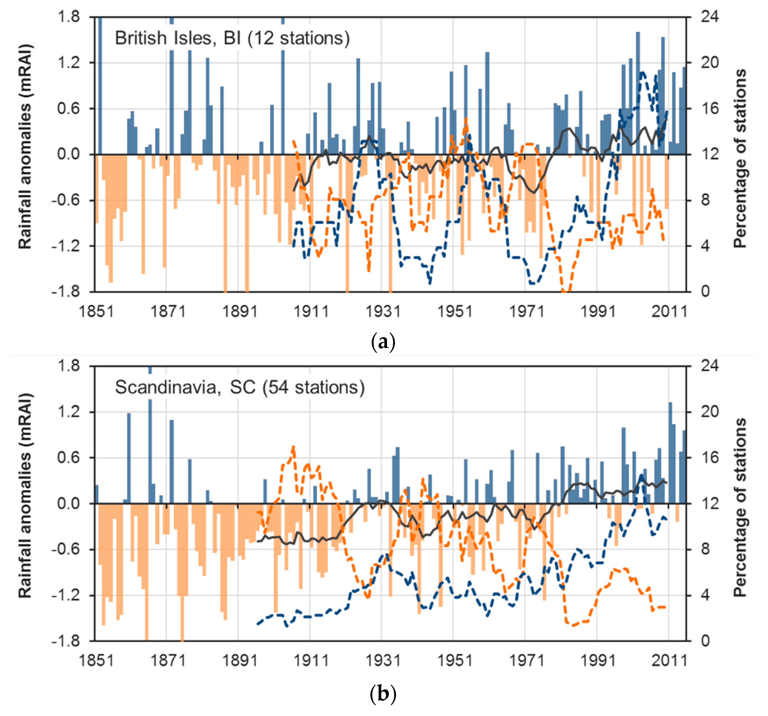
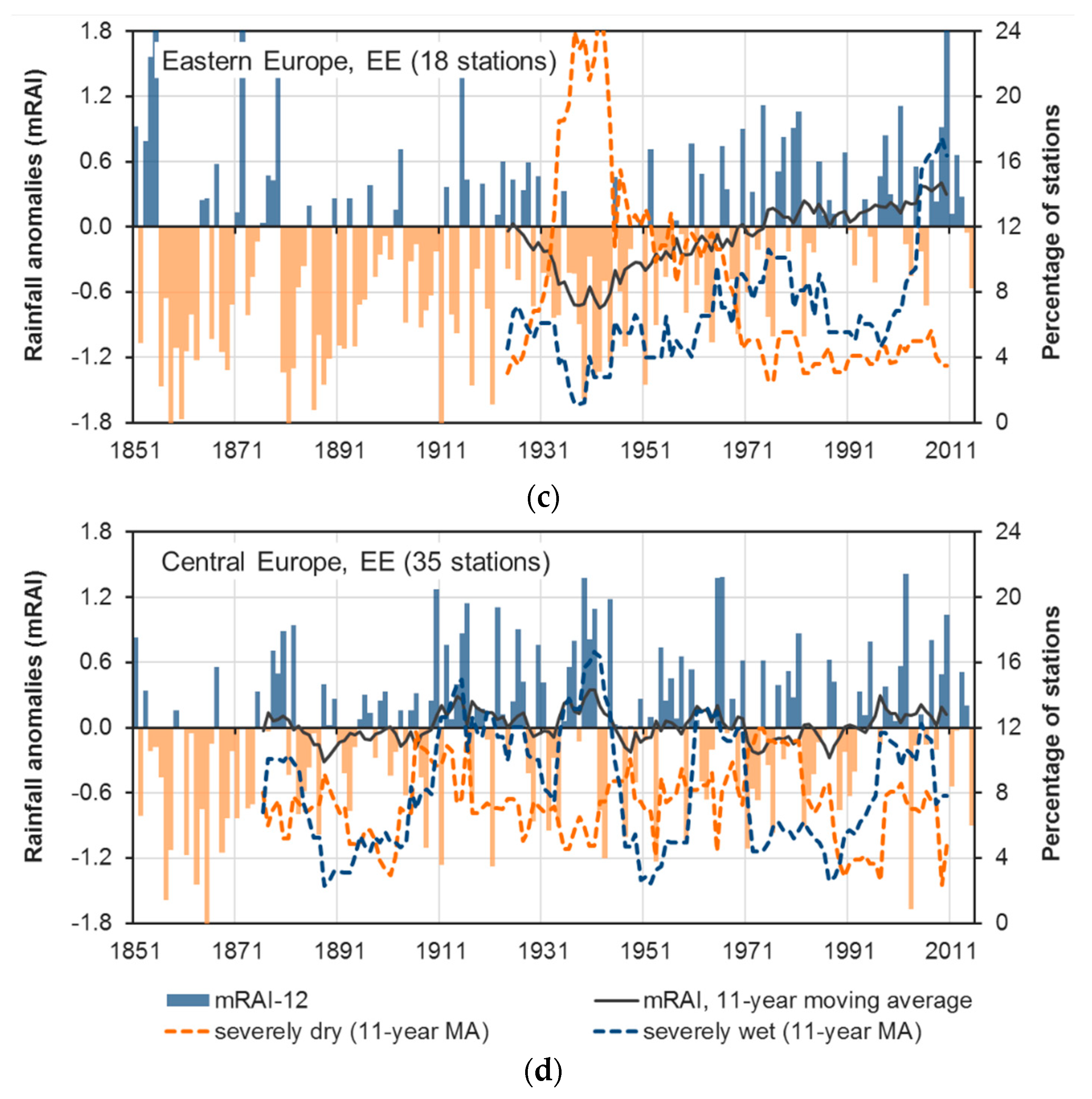
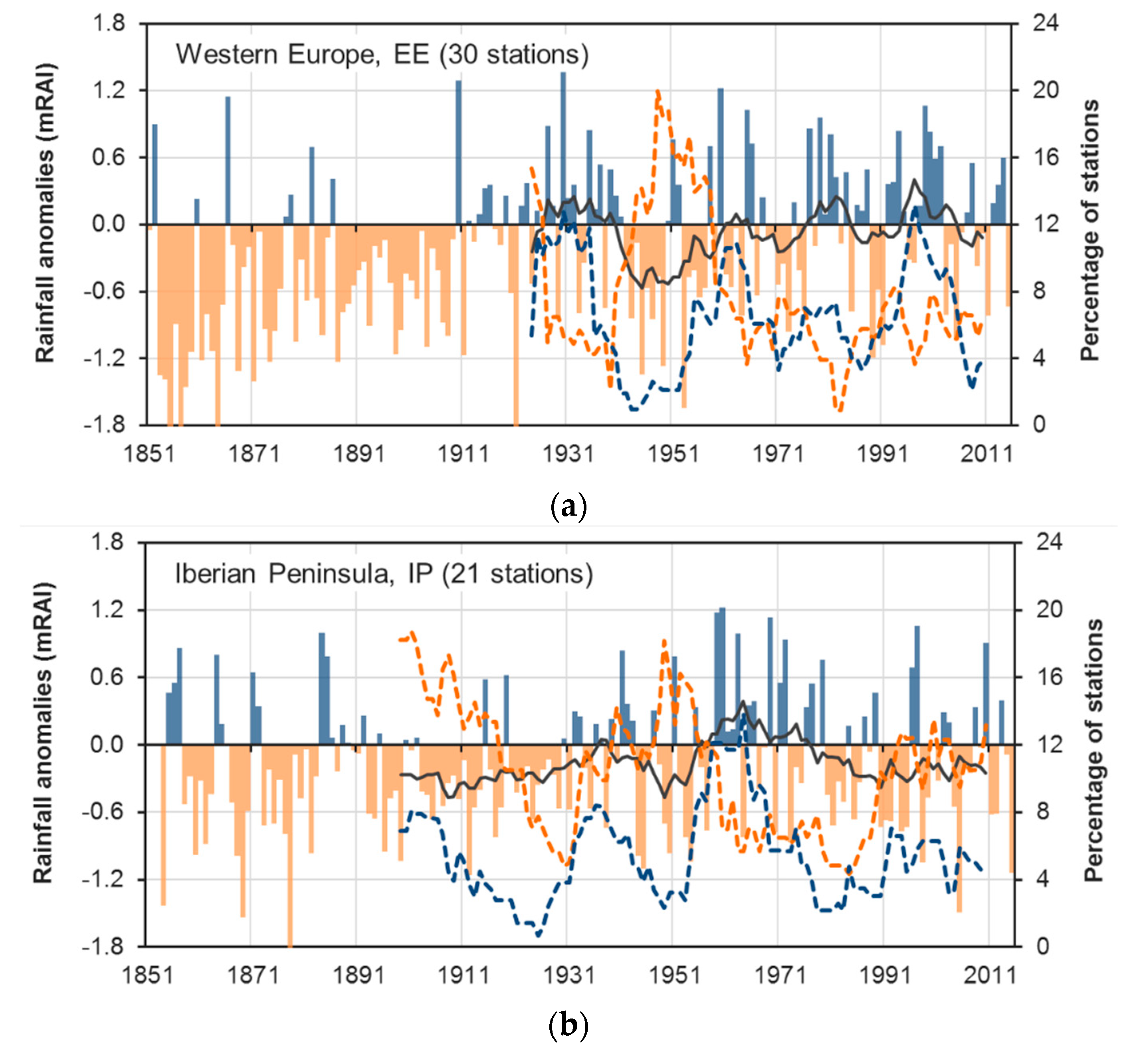
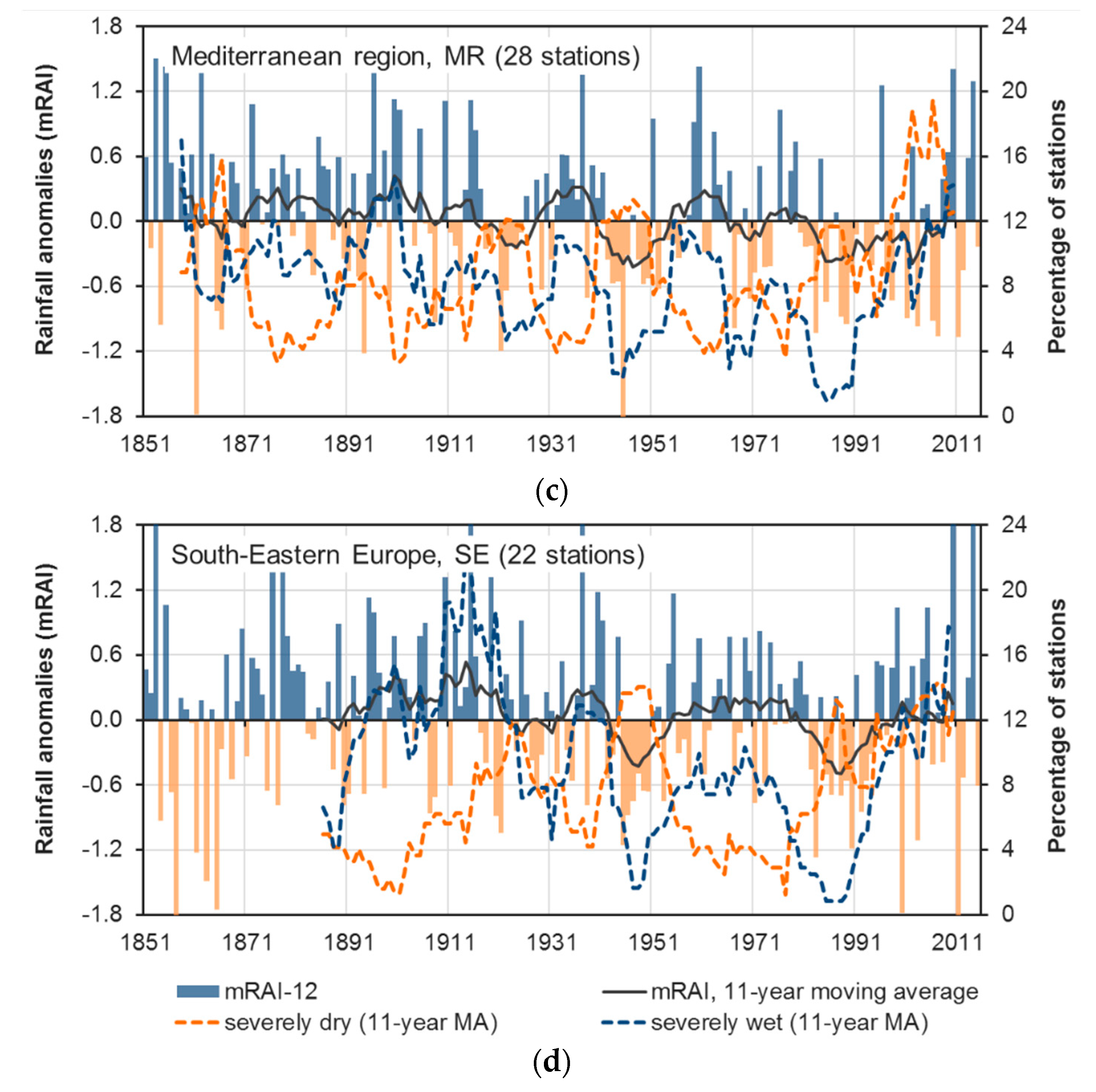
The regions BI (Figure A1a) and SC (Figure A1b) show a precipitation increase since the 1970s that leads to positive linear long-term trends, as displayed in Table 5. With increasing precipitation totals also the percentage of stations under severely wet conditions have increased since the 1970s. Other peaks of severely wet conditions occurred at the end of the 1920s and 1950s in region BI, while severely wet condition in region SC did not show such distinct peaks. Severely dry conditions were particularly frequent in both regions at the beginning of the 20th Century and for region BI additionally during the beginning of the 1950s and 1970s. Increasing precipitation totals and severely wet events are also seen in region EE since the end of the 1930s (Figure A1c). The 1930s until the 1960s were characterized by distinct negative precipitation anomalies with the strongest peak in severely dry years from the mid-1930s until the mid-1940s. Positive anomalies reach the highest values during the most recent years (since 2005), where also severely wet years reach their highest frequency.
No long-term precipitation trend is visible in the precipitation anomaly time series of region CE and just a slight increase in region WE (Table 5). Figure A1d (CE) and Figure A2a (WE) show the pronounced (multi)decadal variability. Frequent severely wet years occurred in region CE during the 1910s, the mid-1930 until the 1940s, the 1960s as well as the beginning of the 21st century, while in region WE severely wet events occurred frequently from the end of the 1920s until the 1930s, during the beginning of the 1960s and the end of the 1990s. Severely dry events were particularly frequent in region CE at the beginning of the 20th century until approximately 1920 and during the 1970s until the beginning of the 1980s. In region WE, the 1940s and 1950s were characterized by a high percentage of stations under severely dry conditions. This is also a period of frequent negative precipitation anomalies that leads to a small positive precipitation trend for the period 1951–2015.
Slight precipitation decreases during the period 1951–2015 are seen in the regions IP, MR, and SE (Table 5); for regions MR and SE, this is also true for the longer study period 1901–2015. Overall, the computed linear trends are small in comparison to the pronounced (multi)decadal variability of precipitation totals (Figure A2b–d). Periods of frequent dry and wet anomalies, respectively, at the beginning or the end of the study period strongly influence the results of the trend analyses. For example, in region IP, the comparatively wet 1960s led to a negative precipitation trend for 1951–2015, while the pronounced and long lasting dry phase at the beginning of the 20th century led to a slightly positive precipitation trend for period 1901–2015 (Figure A2b). Periods with frequent severely dry years occurred in region IP at the beginning of the 19th century and from the end of the 1940s until the mid-1950s. Severely wet years frequently occurred in region IP from the end of the 1950s until the 1960s. Region MR shows a quite regular change between phases of frequent severely dry years and such with frequent wet years (Figure A2c). Just during the most recent decades (approx. since the 1990s), both dry years and wet years occurred quite frequent at the same time, indicating a tendency to more extreme precipitation conditions during a phase of comparatively stable average precipitation totals. A similar behavior can be observed in region SE (Figure A2d), where slightly increasing precipitation totals since the end of the 1980s are connected with a distinct increase in the frequency of severely wet years, while the frequency severely dry years remains at a comparatively high level. The highest frequency of severely wet years occurred in region SE during the 1910s until the beginning of the 1920s. Similarly high frequencies of severely dry years as in recent decades also occurred during the 1940s.
Figure A1.
Time series of annual precipitation anomalies as well as the percentage of stations under severely dry and wet conditions, respectively, for the regions (a) BI, (b) SC, (c) EE, and (d) CE; 1851–2015.
Figure A1.
Time series of annual precipitation anomalies as well as the percentage of stations under severely dry and wet conditions, respectively, for the regions (a) BI, (b) SC, (c) EE, and (d) CE; 1851–2015.


Figure A2.
Time series of annual precipitation anomalies as well as the percentage of stations under severely dry and wet conditions, respectively, for the regions (a) WE, (b) IP, (c) MR, and (d) SE; 1851–2015.
Figure A2.
Time series of annual precipitation anomalies as well as the percentage of stations under severely dry and wet conditions, respectively, for the regions (a) WE, (b) IP, (c) MR, and (d) SE; 1851–2015.


Appendix D
The time series of spatial extent as well as average and maximum duration of dry and wet periods, respectively, are presented in the following figures for the eight sub-regions. All sub-regional time series show a pronounced (multi-)decadal variability and in most cases just comparatively small long-term trends.
Figure A3.
Time series (annual resolution; 11-year low pass filtered data) of spatial extent (SpE; bars for decile index) as well as average (avD) and maximum duration (mxD) of dry (DP) and wet periods (WP) as indicated by the deciles index (dec; orange and light blue) and the mRAI (red and intense blue) for the sub-regions (a) BI and (b) SC for period 1901–2015. For illustration purposes, the WP results are printed as negative values.


Figure A4.
Time series (annual resolution; 11-year low pass filtered data) of spatial extent (SpE; bars for decile index) as well as average (avD) and maximum duration (mxD) of dry (DP) and wet periods (WP) as indicated by the deciles index (dec; orange and light blue) and the mRAI (red and intense blue) for the sub-regions (a) EE, (b) CE, and (c) WE for period 1901–2015. For illustration purposes, the WP results are printed as negative values.


Figure A5.
Time series (annual resolution; 11-year low pass filtered data) of spatial extent (SpE; bars for decile index) as well as average (avD) and maximum duration (mxD) of dry (DP)and wet periods (WP) as indicated by the deciles index (dec; orange and light blue) and the mRAI (red and intense blue) for the sub-regions (a) IP, (b) MR, and (c) SE for period 1901–2015. For illustration purposes, the WP results are printed as negative values.


References
- Quiring, S.M.; Papakryiakou, T.N. An evaluation of agricultural drought indices for the Canadian prairies. Agric. For. Meteorol. 2003, 118, 49–62. [Google Scholar] [CrossRef]
- Ciais, P.; Reichstein, M.; Viovy, N.; Granier, A.; Ogée, J.; Allard, V.; Aubinet, M.; Buchmann, N.; Bernhofer, C.; Carrara, A. Europe-wide reduction in primary productivity caused by the heat and drought in 2003. Nature 2005, 437, 529. [Google Scholar] [CrossRef] [PubMed]
- Hlavinka, P.; Trnka, M.; Semeradova, D.; Dubrovský, M.; Žalud, Z.; Možný, M. Effect of drought on yield variability of key crops in Czech Republic. Agric. For. Meteorol. 2009, 149, 431–442. [Google Scholar] [CrossRef]
- Allen, C.D.; Macalady, A.K.; Chenchouni, H.; Bachelet, D.; McDowell, N.; Vennetier, M.; Kitzberger, T.; Rigling, A.; Breshears, D.D.; Hogg, E.T. A global overview of drought and heat-induced tree mortality reveals emerging climate change risks for forests. For. Ecol. Manag. 2010, 259, 660–684. [Google Scholar] [CrossRef] [Green Version]
- Kogan, F.N. Global Drought Watch from Space. Bull. Am. Meteorol. Soc. 1997, 78, 621–636. [Google Scholar] [CrossRef]
- Buras, A.; Rammig, A.; Zang, C.S. Quantifying impacts of the 2018 drought on European ecosystems in comparison to 2003. Biogeosciences 2020, 17, 1655–1672. [Google Scholar] [CrossRef] [Green Version]
- Kohn, I.; Rosin, K.; Freudiger, D.; Belz, J.U.; Stahl, K.; Weiler, M. Niedrigwasser in Deutschland 2011. Hydrol. Wasserbewirts 2014, 58, 4–17. [Google Scholar]
- Laaha, G.; Gauster, T.; Tallaksen, L.M.; Vidal, J.P.; Stahl, K.; Prudhomme, C.; Heudorfer, B.; Vlnas, R.; Ionita, M.; Van Lanen, H.A.J.; et al. The European 2015 drought from a hydrological perspective. Hydrol. Earth Syst. Sci. 2017, 21, 3001–3024. [Google Scholar] [CrossRef] [Green Version]
- Koehler, G.; Schwab, M.; Finke, W.; Belz, J. An overview of the drought period 2003 in Germany: Causes-impacts-consequences [Ueberblick zur Niedrigwasserperiode 2003 in Deutschland: Ursachen-Wirkungen-Folgen]. Hydrol. Wasserbewirtsch. Hydrol. Water Resour. Manag. Ger. 2007, 51, 118–129. [Google Scholar]
- Nicholson, S.E.; Tucker, C.J.; Ba, M.B. Desertification, Drought, and Surface Vegetation: An Example from the West African Sahel. Bull. Am. Meteorol. Soc. 1998, 79, 815–830. [Google Scholar] [CrossRef]
- Hueso, S.; García, C.; Hernández, T. Severe drought conditions modify the microbial community structure, size and activity in amended and unamended soils. Soil Biol. Biochem. 2012, 50, 167–173. [Google Scholar] [CrossRef]
- Alfieri, L.; Thielen, J. A European precipitation index for extreme rain-storm and flash flood early warning. Meteorol. Appl. 2015, 22, 3–13. [Google Scholar] [CrossRef] [Green Version]
- Hapuarachchi, H.A.P.; Wang, Q.J.; Pagano, T.C. A review of advances in flash flood forecasting. Hydrol. Process. 2011, 25, 2771–2784. [Google Scholar] [CrossRef]
- Van den Besselaar, E.J.M.; Tank, A.; Buishand, T.A. Trends in European precipitation extremes over 1951–2010. Int. J. Climatol. 2013, 33, 2682–2689. [Google Scholar] [CrossRef]
- Fowler, H.J.; Wilby, R.L. Detecting changes in seasonal precipitation extremes using regional climate model projections: Implications for managing fluvial flood risk. Water Resour. Res. 2010, 46, 17. [Google Scholar] [CrossRef] [Green Version]
- Kundzewicz, Z.W. Climate change track in river floods in Europe. In Extreme Hydrological Events; Cudennec, C., Eicker, A., Pilon, P., Stoffel, M., Viglione, A., Xu, Z., Eds.; Copernicus Gesellschaft Mbh: Gottingen, Germany, 2015; Volume 369, pp. 189–194. [Google Scholar]
- Kundzewicz, Z.W.; Hirabayashi, Y.; Kanae, S. River Floods in the Changing Climate-Observations and Projections. Water Resour. Manag. 2010, 24, 2633–2646. [Google Scholar] [CrossRef]
- Kundzewicz, Z.W.; Kanae, S.; Seneviratne, S.I.; Handmer, J.; Nicholls, N.; Peduzzi, P.; Mechler, R.; Bouwer, L.M.; Arnell, N.; Mach, K.; et al. Flood risk and climate change: Global and regional perspectives. Hydrol. Sci. J. 2014, 59, 1–28. [Google Scholar] [CrossRef] [Green Version]
- Trnka, M.; Semerádová, D.; Novotný, I.; Dumbrovský, M.; Drbal, K.; Pavlík, F.; Vopravil, J.; Štěpánková, P.; Vizina, A.; Balek, J.; et al. Assessing the combined hazards of drought, soil erosion and local flooding on agricultural land: A Czech case study. Clim. Res. 2016, 70, 231–249. [Google Scholar] [CrossRef] [Green Version]
- Tapia-Silva, F.-O.; Itzerott, S.; Foerster, S.; Kuhlmann, B.; Kreibich, H. Estimation of flood losses to agricultural crops using remote sensing. Phys. Chem. Earth Parts A B C 2011, 36, 253–265. [Google Scholar] [CrossRef]
- Andrade, L.; O’Dwyer, J.; O’Neill, E.; Hynds, P. Surface water flooding, groundwater contamination, and enteric disease in developed countries: A scoping review of connections and consequences. Environ. Pollut. 2018, 236, 540–549. [Google Scholar] [CrossRef]
- Andrade, L.; O’Malley, K.; Hynds, P.; O’Neill, E.; O’Dwyer, J. Assessment of two behavioural models (HBM and RANAS) for predicting health behaviours in response to environmental threats: Surface water flooding as a source of groundwater contamination and subsequent waterborne infection in the Republic of Ireland. Sci. Total Environ. 2019, 685, 1019–1029. [Google Scholar] [CrossRef] [PubMed]
- Miotliński, K.; Postma, D.; Kowalczyk, A. Variable infiltration and river flooding resulting in changing groundwater quality—A case study from Central Europe. J. Hydrol. 2012, 414–415, 211–219. [Google Scholar] [CrossRef]
- Katsanos, D.; Retalis, A.; Tymvios, F.; Michaelides, S. Study of extreme wet and dry periods in Cyprus using climatic indices. Atmos. Res. 2018, 208, 88–93. [Google Scholar] [CrossRef]
- Caloiero, T.; Sirangelo, B.; Coscarelli, R.; Ferrari, E. An Analysis of the Occurrence Probabilities of Wet and Dry Periods through a Stochastic Monthly Rainfall Model. Water 2016, 8, 39. [Google Scholar] [CrossRef] [Green Version]
- Zolina, O. Multidecadal trends in the duration of wet spells and associated intensity of precipitation as revealed by a very dense observational German network. Environ. Res. Lett. 2014, 9, 2. [Google Scholar] [CrossRef]
- Cindrić, K.; Pasarić, Z.; Gajić-Čapka, M.J.T.; Climatology, A. Spatial and temporal analysis of dry spells in Croatia. Theor. Appl. Climatol. 2010, 102, 171–184. [Google Scholar] [CrossRef]
- Fakhri, M.; Farzaneh, M.R.; Eslamian, S.; Khordadi, M.J. Confidence Interval Assessment to Estimate Dry and Wet Spells under Climate Change in Shahrekord Station, Iran. J. Hydrol. Eng. 2013, 18, 911–918. [Google Scholar] [CrossRef]
- Lana, X.; Martínez, M.D.; Burgueño, A.; Serra, C.; Martín-Vide, J.; Gómez, L. Spatial and temporal patterns of dry spell lengths in the Iberian Peninsula for the second half of the twentieth century. Theor. Appl. Climatol. 2008, 91, 99–116. [Google Scholar] [CrossRef]
- Sanchez, E.; Dominguez, M.; Romera, R.; de la Franca, N.L.; Gaertner, M.A.; Gallardo, C.; Castro, M. Regional modeling of dry spells over the Iberian Peninsula for present climate and climate change conditions. Clim. Chang. 2011, 107, 625–634. [Google Scholar] [CrossRef]
- Serra, C.; Martinez, M.D.; Lana, X.; Burgueno, A. European dry spell regimes (1951–2000): Clustering process and time trends. Atmos. Res. 2014, 144, 151–174. [Google Scholar] [CrossRef]
- Anagnostopoulou, C.; Maheras, P.; Karacostas, T.; Vafiadis, M. Spatial and temporal analysis of dry spells in Greece. Theor. Appl. Climatol. 2003, 74, 77–91. [Google Scholar] [CrossRef]
- Caloiero, T.; Coscarelli, R.; Ferrari, E.; Sirangelo, B. Analysis of dry spells in southern Italy (Calabria). Water 2015, 7, 3009–3023. [Google Scholar] [CrossRef]
- Spinoni, J.; Naumann, G.; Vogt, J.; Barbosa, P. European drought climatologies and trends based on a multi-indicator approach. Glob. Planet. Chang. 2015, 127, 50–57. [Google Scholar] [CrossRef]
- Spinoni, J.; Naumann, G.; Vogt, J.V.; Barbosa, P. The biggest drought events in Europe from 1950 to 2012. J. Hydrol. Regional Stud. 2015, 3, 509–524. [Google Scholar] [CrossRef]
- Bordi, I.; Sutera, A. Drought monitoring and forecasting at large scale. In Methods and Tools for Drought Analysis and Management. Series Water Science and Technology Library; Rossi, G., Vega, T., Bonaccorso, B., Eds.; Springer: New York, NY, USA, 2007; Volume 62. [Google Scholar]
- Zargar, A.; Sadiq, R.; Naser, B.; Khan, F.I. A review of drought indices. Environ. Rev. 2011, 19, 333–349. [Google Scholar] [CrossRef]
- Keyantash, J.; Dracup, J.A. The quantification of drought: An evaluation of drought indices. Bull. Am. Meteorol. Soc. 2002, 83, 1167–1180. [Google Scholar] [CrossRef]
- Dracup, J.A.; Lee, K.S.; Paulson, E.G., Jr. On the definition of droughts. Water Resour. Res. 1980, 16, 297–302. [Google Scholar] [CrossRef]
- Hayes, M.; Svoboda, M.; Wall, N.; Widhalm, M. The Lincoln declaration on drought indices: Universal meteorological drought index recommended. Bull. Am. Meteorol. Soc. 2011, 92, 485–488. [Google Scholar] [CrossRef] [Green Version]
- Wilhite, D.A.; Glantz, M.H. Understanding: The Drought Phenomenon: The Role of Definitions. Water Int. 1985, 10, 111–120. [Google Scholar] [CrossRef] [Green Version]
- McKee, T.B.; Doesken, N.J.; Kleist, J. The Relationship of Drought Frequency and Duration to Time Scales; American Meteorological Society: Boston, MA, USA, 1993; pp. 179–183. [Google Scholar]
- Vicente-Serrano, S.M.; Beguería, S.; López-Moreno, J.I. A multiscalar drought index sensitive to global warming: The standardized precipitation evapotranspiration index. J. Clim. 2010, 23, 1696–1718. [Google Scholar] [CrossRef] [Green Version]
- Palmer, W.C. Meteorological Drought; US Department of Commerce: Weather Bureau: Silver Spring, MD, USA, 1965; Volume 30.
- Stagge, J.H.; Kohn, I.; Tallaksen, L.M.; Stahl, K. Modeling drought impact occurrence based on meteorological drought indices in Europe. J. Hydrol. 2015, 530, 37–50. [Google Scholar] [CrossRef]
- Vicente-Serrano, S.M.; Beguería, S.; Lorenzo-Lacruz, J.; Camarero, J.J.; López-Moreno, J.I.; Azorin-Molina, C.; Revuelto, J.; Morán-Tejeda, E.; Sanchez-Lorenzo, A. Performance of drought indices for ecological, agricultural, and hydrological applications. Earth Interact. 2012, 16, 1–27. [Google Scholar] [CrossRef] [Green Version]
- Vicente-Serrano, S.M.; Gouveia, C.; Camarero, J.J.; Begueria, S.; Trigo, R.; Lopez-Moreno, J.I.; Azorin-Molina, C.; Pasho, E.; Lorenzo-Lacruz, J.; Revuelto, J.; et al. Response of vegetation to drought time-scales across global land biomes. Proc. Natl. Acad. Sci. USA 2013, 110, 52–57. [Google Scholar] [CrossRef] [Green Version]
- Vicente-Serrano, S.M.; Lopez-Moreno, J.I. Hydrological response to different time scales of climatological drought: An evaluation of the Standardized Precipitation Index in a mountainous Mediterranean basin. Hydrol. Earth Syst. Sci. 2005, 9, 523–533. [Google Scholar] [CrossRef] [Green Version]
- Wang, Q.; Wu, J.; Lei, T.; He, B.; Wu, Z.; Liu, M.; Mo, X.; Geng, G.; Li, X.; Zhou, H. Temporal-spatial characteristics of severe drought events and their impact on agriculture on a global scale. Quat. Int. 2014, 349, 10–21. [Google Scholar] [CrossRef]
- Bachmair, S.; Kohn, I.; Stahl, K. Exploring the link between drought indicators and impacts. Nat. Hazards Earth Syst. Sci. 2015, 15, 1381–1397. [Google Scholar] [CrossRef] [Green Version]
- McEvoy, D.J.; Huntington, J.L.; Abatzoglou, J.T.; Edwards, L.M.J.E.I. An evaluation of multiscalar drought indices in Nevada and eastern California. Earth Interact. 2012, 16, 1–18. [Google Scholar] [CrossRef]
- Lorenzo-Lacruz, J.; Vicente-Serrano, S.M.; Gonzalez-Hidalgo, J.C.; Lopez-Moreno, J.I.; Cortesi, N. Hydrological drought response to meteorological drought in the Iberian Peninsula. Clim. Res. 2013, 58, 117–131. [Google Scholar] [CrossRef] [Green Version]
- López-Moreno, J.I.; Vicente-Serrano, S.M.; Zabalza, J.; Beguería, S.; Lorenzo-Lacruz, J.; Azorín-Molina, C.; Morán-Tejeda, E. Hydrological response to climate variability at different time scales: A study in the Ebro basin. J. Hydrol. 2013, 477, 175–188. [Google Scholar] [CrossRef] [Green Version]
- Alexander, L.V.; Zhang, X.; Peterson, T.C.; Caesar, J.; Gleason, B.; Tank, A.; Haylock, M.; Collins, D.; Trewin, B.; Rahimzadeh, F.; et al. Global observed changes in daily climate extremes of temperature and precipitation. J. Geophys. Res. Atmos. 2006, 111, D5. [Google Scholar] [CrossRef] [Green Version]
- Niedźwiedź, T.; Twardosz, R.; Walanus, A. Long-term variability of precipitation series in east central Europe in relation to circulation patterns. Theor. Appl. Climatol. 2009, 98, 337–350. [Google Scholar] [CrossRef]
- Lupikasza, E.B.; Hansel, S.; Matschullat, J. Regional and seasonal variability of extreme precipitation trends in southern Poland and central-eastern Germany 1951–2006. Int. J. Climatol. 2011, 31, 2249–2271. [Google Scholar] [CrossRef]
- IPCC. Climate Change 2013: The Physical Science Basis. Contribution of Working Group I to the Fifth Assessment Report of the Intergovernmental Panel on Climate Change; Cambridge University Press: Cambridge, UK; New York, NY, USA, 2013; p. 1535. [Google Scholar]
- Stagge, J.H.; Kingston, D.G.; Tallaksen, L.M.; Hannah, D.M. Observed drought indices show increasing divergence across Europe. Sci. Rep. 2017, 7, 10. [Google Scholar] [CrossRef] [PubMed]
- Sousa, P.M.; Trigo, R.M.; Aizpurua, P.; Nieto, R.; Gimeno, L.; Garcia-Herrera, R. Trends and extremes of drought indices throughout the 20th century in the Mediterranean. Nat. Hazards Earth Syst. Sci. 2011, 11, 33–51. [Google Scholar] [CrossRef] [Green Version]
- Hoerling, M.; Eischeid, J.; Perlwitz, J.; Quan, X.; Zhang, T.; Pegion, P. On the Increased Frequency of Mediterranean Drought. J. Clim. 2012, 25, 2146–2161. [Google Scholar] [CrossRef] [Green Version]
- Vicente-Serrano, S.M.; Lopez-Moreno, J.I.; Begueria, S.; Lorenzo-Lacruz, J.; Sanchez-Lorenzo, A.; Garcia-Ruiz, J.M.; Azorin-Molina, C.; Moran-Tejeda, E.; Revuelto, J.; Trigo, R.; et al. Evidence of increasing drought severity caused by temperature rise in southern Europe. Environ. Res. Lett. 2014, 9, 4. [Google Scholar] [CrossRef]
- Wanders, N.; Wada, Y.; Van Lanen, H.A.J. Global hydrological droughts in the 21st century under a changing hydrological regime. Earth Sys. Dyn. 2015, 6, 1–15. [Google Scholar] [CrossRef] [Green Version]
- Mariotti, A.; Zeng, N.; Yoon, J.-H.; Artale, V.; Navarra, A.; Alpert, P.; Li, L.Z.X. Mediterranean water cycle changes: Transition to drier 21st century conditions in observations and CMIP3 simulations. Environ. Res. Lett. 2008, 3, 044001. [Google Scholar] [CrossRef]
- Orlowsky, B.; Seneviratne, S.I. Elusive drought: Uncertainty in observed trends and short- and long-term CMIP5 projections. Hydrol. Earth Syst. Sci. 2013, 17, 1765–1781. [Google Scholar] [CrossRef] [Green Version]
- Cook, B.I.; Smerdon, J.E.; Seager, R.; Coats, S. Global warming and 21st century drying. Clim. Dyn. 2014, 43, 2607–2627. [Google Scholar] [CrossRef] [Green Version]
- Alpert, P.; Ben-Gai, T.; Baharad, A.; Benjamini, Y.; Yekutieli, D.; Colacino, M.; Diodato, L.; Ramis, C.; Homar, V.; Romero, R.; et al. The paradoxical increase of Mediterranean extreme daily rainfall in spite of decrease in total values. Geophys. Res. Lett. 2002, 29. [Google Scholar] [CrossRef] [Green Version]
- Groisman, P.Y.; Karl, T.R.; Easterling, D.R.; Knight, R.W.; Jamason, P.F.; Hennessy, K.J.; Suppiah, R.; Page, C.M.; Wibig, J.; Fortuniak, K.; et al. Changes in the probability of heavy precipitation: Important indicators of climatic change. Clim. Chang. 1999, 42, 243–283. [Google Scholar] [CrossRef]
- Groisman, P.Y.; Knight, R.W.; Easterling, D.R.; Karl, T.R.; Hegerl, G.C.; Razuvaev, V.A.N. Trends in intense precipitation in the climate record. J. Clim. 2005, 18, 1326–1350. [Google Scholar] [CrossRef]
- Easterling, D.R.; Evans, J.L.; Groisman, P.Y.; Karl, T.R.; Kunkel, K.E.; Ambenje, P. Observed Variability and Trends in Extreme Climate Events: A Brief Review. Bull. Am. Meteorol. Soc. 2000, 81, 417–426. [Google Scholar] [CrossRef] [Green Version]
- Klein Tank, A.M.G.; Können, G.P. Trends in Indices of Daily Temperature and Precipitation Extremes in Europe, 1946–99. J. Clim. 2003, 16, 3665–3680. [Google Scholar] [CrossRef]
- Heinrich, G.; Gobiet, A. The future of dry and wet spells in Europe: A comprehensive study based on the ENSEMBLES regional climate models. Int. J. Climatol. 2012, 32, 1951–1970. [Google Scholar] [CrossRef]
- Frich, P.; Alexander, L.V.; Della-Marta, P.; Gleason, B.; Haylock, M.; Tank, A.K.; Peterson, T. Observed coherent changes in climatic extremes during the second half of the twentieth century. Clim. Res. 2002, 19, 193–212. [Google Scholar] [CrossRef] [Green Version]
- Moberg, A.; Jones, P.D. Trends in indices for extremes in daily temperature and precipitation in central and western Europe, 1901–1999. Int. J. Climatol. 2005, 25, 1149–1171. [Google Scholar] [CrossRef]
- Kysely, J. Trends in heavy precipitation in the Czech Republic over 1961–2005. Int. J. Climatol. 2009, 29, 1745–1758. [Google Scholar] [CrossRef]
- Christensen, J.H.; Christensen, O.B. A summary of the PRUDENCE model projections of changes in European climate by the end of this century. Clim. Chang. 2007, 81, 7–30. [Google Scholar] [CrossRef]
- Tsakiris, G.; Vangelis, H. Establishing a drought index incorporating evapotranspiration. J. Eur. Water 2005, 9, 3–11. [Google Scholar]
- Briffa, K.; Jones, P.; Hulme, M. Summer moisture variability across Europe, 1892–1991: An analysis based on the Palmer drought severity index. Int. J. Climatol. 1994, 14, 475–506. [Google Scholar] [CrossRef]
- Lloyd-Hughes, B.; Saunders, M.A. A drought climatology for Europe. Int. J. Climatol. 2002, 22, 1571–1592. [Google Scholar] [CrossRef]
- Van der Schrier, G.; Briffa, K.; Jones, P.; Osborn, T. Summer moisture variability across Europe. J. Clim. 2006, 19, 2818–2834. [Google Scholar] [CrossRef]
- Vicente-Serrano, S.M.; Domínguez-Castro, F.; Murphy, C.; Hannaford, J.; Reig, F.; Peña-Angulo, D.; Tramblay, Y.; Trigo, R.M.; Mac Donald, N.; Luna, M.Y.; et al. Long-term variability and trends in meteorological droughts in Western Europe (1851–2018). Int. J. Climatol. 2020. [Google Scholar] [CrossRef]
- Klein Tank, A.M.G.; Wijngaard, J.B.; Können, G.P.; Böhm, R.; Demarée, G.; Gocheva, A.; Mileta, M.; Pashiardis, S.; Hejkrlik, L.; Kern-Hansen, C.; et al. Daily dataset of 20th-century surface air temperature and precipitation series for the European Climate Assessment. Int. J. Climatol. 2002, 22, 1441–1453. [Google Scholar] [CrossRef]
- Wijngaard, J.B.; Klein Tank, A.M.G.; Können, G.P. Homogeneity of 20th century European daily temperature and precipitation series. Int. J. Climatol. 2003, 23, 679–692. [Google Scholar] [CrossRef]
- Gibbs, W.J.; Maher, J. Rainfall Deciles as Drought Indicators; Bureau of Meteorology: Melbourne, Australia, 1967; p. 84.
- Kinninmonth, W.; Voice, M.; Beard, G.; De Hoedt, G.; Mullen, C. Australian climate services for drought management. In Drought: A Global Assessment; Wilhite, D., Ed.; Routledge: London, UK; New York, NY, USA, 2000; Volume 1, pp. 210–222. [Google Scholar]
- Hänsel, S. Introducing the decile concept for studying the spatiotemporal characteristics and variability of long-lasting dry and wet periods. Theor. Appl. Climatol. 2014, 118, 223–235. [Google Scholar] [CrossRef]
- Hänsel, S.; Schucknecht, A.; Matschullat, J. The Modified Rainfall Anomaly Index (mRAI)—Is this an alternative to the Standardised Precipitation Index (SPI) in evaluating future extreme precipitation characteristics? Theor. Appl. Climatol. 2016, 123, 827–844. [Google Scholar] [CrossRef]
- Van Rooy, M. A rainfall anomaly index independent of time and space. Notos 1965, 14, 6. [Google Scholar]
- Hoy, A.; Hänsel, S.; Skalak, P.; Ustrnul, Z.; Bochníček, O. The extreme European summer of 2015 in a long-term perspective. Int. J. Climatol. 2017, 37, 943–962. [Google Scholar] [CrossRef]
- Briffa, K.R.; van der Schrier, G.; Jones, P.D. Wet and dry summers in Europe since 1750: Evidence of increasing drought. Int. J. Climatol. 2009, 29, 1894–1905. [Google Scholar] [CrossRef]
- Spinoni, J.; Naumann, G.; Vogt, J.V. Pan-European seasonal trends and recent changes of drought frequency and severity. Glob. Planet. Chang. 2017, 148, 113–130. [Google Scholar] [CrossRef]
- Gudmundsson, L.; Seneviratne, S.I. European drought trends. In Extreme Hydrological Events; Cudennec, C., Eicker, A., Pilon, P., Stoffel, M., Viglione, A., Xu, Z., Eds.; Copernicus Gesellschaft Mbh: Gottingen, Germany, 2015; Volume 369, pp. 75–79. [Google Scholar]
- Hänsel, S.; Ustrnul, Z.; Łupikasza, E.; Skalak, P. Assessing seasonal drought variations and trends over Central Europe. Adv. Water Resour. 2019, 127, 53–75. [Google Scholar] [CrossRef]
- Rebetez, M.; Mayer, H.; Dupont, O.; Schindler, D.; Gartner, K.; Kropp, J.P.; Menzel, A. Heat and drought 2003 in Europe: A climate synthesis. Ann. For. Sci. 2006, 63, 569–577. [Google Scholar] [CrossRef] [Green Version]
- Zahradníček, P.; Trnka, M.; Brázdil, R.; Možný, M.; Štěpánek, P.; Hlavinka, P.; Žalud, Z.; Malý, A.; Semerádová, D.; Dobrovolný, P. The extreme drought episode of August 2011–May 2012 in the Czech Republic. Int. J. Climatol. 2015, 35, 3335–3352. [Google Scholar] [CrossRef]
- Ionita, M.; Tallaksen, L.M.; Kingston, D.G.; Stagge, J.H.; Laaha, G.; Van Lanen, H.A.J.; Scholz, P.; Chelcea, S.M.; Haslinger, K. The European 2015 drought from a climatological perspective. Hydrol. Earth Sys. Sci. 2017, 21, 1397–1419. [Google Scholar] [CrossRef] [Green Version]
- Hari, V.; Rakovec, O.; Markonis, Y.; Hanel, M.; Kumar, R. Increased future occurrences of the exceptional 2018–2019 Central European drought under global warming. Sci. Rep. 2020, 10, 12207. [Google Scholar] [CrossRef]
- Boergens, E.; Güntner, A.; Dobslaw, H.; Dahle, C. Quantifying the Central European Droughts in 2018 and 2019 with GRACE Follow-On. Geophys. Res. Lett. 2020, 47, e2020GL087285. [Google Scholar] [CrossRef]
- Brazdil, R.; Raska, P.; Trnka, M.; Zahradnicek, P.; Valasek, H.; Dobrovolny, P.; Reznickova, L.; Treml, P.; Stachon, Z. The Central European drought of 1947: Causes and consequences, with particular reference to the Czech Lands. Clim. Res. 2016, 70, 161–178. [Google Scholar] [CrossRef] [Green Version]
- Brönnimann, S.; Stickler, A.; Griesser, T.; Fischer, A.M.; Grant, A.; Ewen, T.; Zhou, T.; Schraner, M.; Rozanov, E.; Peter, T. Variability of large-scale atmospheric circulation indices for the Northern Hemisphere during the past 100 years. Meteorol. Z. 2009, 18, 379–396. [Google Scholar] [CrossRef]
- Haslinger, K.; Hofstätter, M.; Kroisleitner, C.; Schöner, W.; Laaha, G.; Holawe, F.; Blöschl, G. Disentangling Drivers of Meteorological Droughts in the European Greater Alpine Region During the Last Two Centuries. J. Geophys. Res. Atmos. 2019, 124, 12404–12425. [Google Scholar] [CrossRef] [PubMed] [Green Version]
- Wang, K.; Dickinson, R.E.; Liang, S. Global Atmospheric Evaporative Demand over Land from 1973 to 2008. J. Clim. 2012, 25, 8353–8361. [Google Scholar] [CrossRef]
- Dai, A. Drought under global warming: A review. Wiley Interdiscip. Rev. Clim. Chang. 2011, 2, 45–65. [Google Scholar] [CrossRef] [Green Version]
- Hegerl, G.C.; Hanlon, H.; Beierkuhnlein, C. Elusive extremes. Nat. Geosci. 2011, 4, 142. [Google Scholar] [CrossRef]
- Graczyk, D.; Kundzewicz, Z.W. Changes in thermal extremes in Poland. Acta Geophys. 2014, 62, 1435–1449. [Google Scholar] [CrossRef]
- Sedlmeier, K.; Feldmann, H.; Schadler, G. Compound summer temperature and precipitation extremes over central Europe. Theor. Appl. Climatol. 2018, 131, 1493–1501. [Google Scholar] [CrossRef]
- Hanel, M.; Rakovec, O.; Markonis, Y.; Máca, P.; Samaniego, L.; Kyselý, J.; Kumar, R. Revisiting the recent European droughts from a long-term perspective. Sci. Rep. 2018, 8, 9499. [Google Scholar] [CrossRef]
Figure 1.
(a) Location of the 220 rain gauge stations and (b) number of stations with digitally available monthly precipitation time series between 1851 and 2015. The stations are grouped into eight regions (BI: British Isles, CE: Central Europe, EE: Eastern Europe, IP: Iberian Peninsula, MR: Mediterranean Region, SC: Scandinavia, SE: South Eastern Europe, WE: Western Europe).

Figure 2.
Occurrence of dry (orange bars) and wet periods (blue bars) at 220 stations within the eight sub-regions (for region abbreviations please refer to Figure 1) in Europe from 1851 to 2015 (light grey: missing data; white: no event). Part (a) shows the results for the decile index and (b) those for the mRAI.

Figure 3.
Cumulative frequency distribution of the duration of dry (DP) and wet periods (WP) for period 1966–2015. Part (a) show the results for Europe (average of 220 stations) according to the decile and mRAI definition. The parts (b) and (c) show the results of the sub-regional analysis for decile-DP (b) and decile-WP (c). Therefore, the region abbreviations and colors used for lines of individual sub-regions refer to those introduced in Figure 1.

Figure 4.
Time series (annual resolution) of European precipitation anomalies (average of at most 220 stations; for variations in the data availability please refer to Figure 1b) within 1851–2015. Additionally, the 11-year moving averages are shown. They only start in 1924, when all eight sub-regions have a data availability of at least 50%. Part (a) presents the annual rainfall anomalies (mRAI-12 for December; please note that here negative anomalies are connected to dry conditions) and part (b) the relative frequency of severely dry (percentage of stations with a mRAI < −1.5) and wet years (percentage of stations with a mRAI > 1.5; please note that for illustration purposes the results for severely wet years are printed as negative values.

Figure 5.
Time series (11-year moving averages) of the seasonal European precipitation anomalies (mRAI-3 for May, August, November, and February; station average) for period 1921–2015.
Figure 5.
Time series (11-year moving averages) of the seasonal European precipitation anomalies (mRAI-3 for May, August, November, and February; station average) for period 1921–2015.

Figure 6.
Time series of (a) spatial extent, (b) average, and (c) maximum duration of dry (DP) and wet periods (WP) as indicated by the deciles index and the mRAI for Europe (220 stations) for period 1851–2015. For illustration purposes, the WP results are printed as negative values. The time series in monthly resolution are only printed for the deciles index, while the 5-year and a 30-year low-pass filtered data (from 1924) are printed for both indices.


Table 1.
Classification of the Modified Rainfall Anomaly Index (mRAI) into moisture classes.
| Class | mRAI-Value | Description |
|---|---|---|
| 1 | ≥2.00 | Extremely wet |
| 2 | 1.50 to 1.99 | Very wet |
| 3 | 1.00 to 1.49 | Moderately wet |
| 4 | 0.50 to 0.99 | Slightly wet |
| 5 | −0.49 to 0.49 | Near normal |
| 6 | −0.99 to −0.50 | Slightly dry |
| 7 | −1.49 to −1.00 | Moderately dry |
| 8 | −1.99 to −1.50 | Very dry |
| 9 | ≤−2.00 | Extremely dry |
Table 2.
Displayed are characteristics of dry and wet periods (spatial extent, duration, and frequency) for Europe and the eight sub-regions (for the region abbreviations BI, CE, EE, IP, MR, SC, SE, and WE please refer to Figure 1) comparing three 50-year periods (1866–1915, 1916–1965, and 1966–2015). Two different dry and wet period definitions are used: D for decile periods and R for the mRAI periods. The first rows show the number of the stations per regions with a data availability above 50% in the respective study period. Results for periods with low data availability (≤50% of the stations are available) are printed in light grey.
| Studied Variable | Study Period | Europe | BI | SC | EE | CE | WE | IP | MR | SE | |||||||||
|---|---|---|---|---|---|---|---|---|---|---|---|---|---|---|---|---|---|---|---|
| D | R | D | R | D | R | D | R | D | R | D | R | D | R | D | R | D | R | ||
| Number of stations * | 1866–1915 | 122 | 8 | 32 | 3 | 27 | 6 | 8 | 27 | 11 | |||||||||
| 1916–1965 | 204 | 12 | 53 | 11 | 31 | 28 | 19 | 28 | 22 | ||||||||||
| 1966–2015 | 220 | 12 | 54 | 18 | 35 | 30 | 21 | 28 | 22 | ||||||||||
| Decile Dry Periods | |||||||||||||||||||
| Spatial extent [%] | 1866–1915 | 34 | 33 | 35 | 33 | 46 | 41 | 45 | 41 | 35 | 33 | 43 | 38 | 31 | 37 | 26 | 29 | 25 | 25 |
| 1916–1965 | 34 | 33 | 31 | 30 | 36 | 34 | 45 | 43 | 33 | 30 | 36 | 33 | 27 | 34 | 30 | 32 | 32 | 32 | |
| 1966–2015 | 28 | 29 | 27 | 27 | 25 | 26 | 24 | 26 | 31 | 29 | 29 | 29 | 28 | 34 | 30 | 32 | 29 | 31 | |
| Average duration [months] | 1866–1915 | 7.6 | 4.7 | 6.8 | 4.5 | 9.8 | 5.4 | 11.8 | 6.0 | 7.2 | 4.4 | 9.8 | 5.7 | 6.4 | 4.8 | 5.7 | 4.1 | 5.5 | 3.7 |
| 1916–1965 | 7.5 | 4.7 | 7.1 | 4.5 | 8.6 | 5.0 | 8.1 | 5.7 | 7.4 | 4.6 | 8.1 | 4.8 | 5.7 | 4.4 | 6.3 | 4.5 | 7.0 | 4.6 | |
| 1966–2015 | 6.9 | 4.4 | 6.5 | 4.1 | 7.0 | 4.3 | 6.7 | 4.2 | 7.5 | 4.4 | 7.6 | 4.4 | 5.7 | 4.3 | 6.8 | 4.5 | 6.8 | 4.6 | |
| Median duration [months] | 1866–1915 | 5.8 | 3.6 | 5.8 | 3.5 | 7.8 | 4.2 | 8.2 | 4.8 | 5.4 | 3.4 | 7.6 | 4.6 | 4.1 | 3.2 | 4.2 | 3.1 | 4.4 | 2.9 |
| 1916–1965 | 5.7 | 3.6 | 5.6 | 3.5 | 6.3 | 3.8 | 6.1 | 4.2 | 5.7 | 3.6 | 6.3 | 3.5 | 4.5 | 3.4 | 5.1 | 3.6 | 5.3 | 3.5 | |
| 1966–2015 | 5.3 | 3.4 | 5.2 | 3.3 | 5.2 | 3.3 | 5.1 | 3.2 | 5.7 | 3.4 | 5.6 | 3.5 | 4.4 | 3.4 | 5.4 | 3.4 | 5.4 | 3.5 | |
| Frequency per 10 years | 1866–1915 | 5.7 | 8.8 | 6.1 | 8.6 | 5.6 | 9.1 | 5.9 | 9.7 | 5.9 | 9.0 | 5.7 | 8.3 | 5.3 | 8.8 | 5.5 | 8.7 | 5.5 | 8.4 |
| 1916–1965 | 5.5 | 8.4 | 5.5 | 8.2 | 5.2 | 8.2 | 6.3 | 9.0 | 5.3 | 8.0 | 5.4 | 8.3 | 5.8 | 9.3 | 5.6 | 8.6 | 5.5 | 8.3 | |
| 1966–2015 | 5.0 | 8.1 | 5.0 | 8.0 | 4.7 | 7.6 | 4.6 | 7.5 | 5.0 | 8.0 | 4.6 | 7.9 | 6.0 | 9.5 | 5.4 | 8.8 | 5.2 | 8.2 | |
| Decile Wet Periods | |||||||||||||||||||
| Spatial extent [%] | 1866–1915 | 27 | 23 | 25 | 23 | 21 | 18 | 17 | 18 | 28 | 24 | 17 | 17 | 26 | 20 | 33 | 28 | 36 | 31 |
| 1916–1965 | 28 | 24 | 28 | 25 | 25 | 22 | 22 | 20 | 32 | 27 | 25 | 23 | 25 | 22 | 30 | 26 | 31 | 27 | |
| 1966–2015 | 30 | 26 | 30 | 28 | 34 | 30 | 32 | 29 | 29 | 25 | 29 | 26 | 25 | 22 | 27 | 24 | 29 | 26 | |
| Average duration [months] | 1866–1915 | 6.1 | 4.0 | 5.9 | 4.0 | 5.3 | 3.5 | 4.6 | 3.5 | 6.2 | 4.1 | 5.7 | 3.5 | 7.2 | 4.2 | 6.8 | 4.4 | 7.0 | 4.5 |
| 1916–1965 | 6.9 | 4.5 | 6.6 | 4.3 | 6.8 | 4.4 | 5.7 | 4.0 | 7.3 | 4.6 | 7.0 | 4.8 | 6.6 | 4.3 | 7.2 | 4.4 | 7.1 | 4.5 | |
| 1966–2015 | 7.3 | 4.5 | 6.5 | 4.2 | 7.8 | 4.7 | 7.7 | 4.7 | 7.5 | 4.3 | 7.6 | 4.8 | 6.2 | 4.2 | 6.8 | 4.4 | 7.3 | 4.5 | |
| Median duration [months] | 1866–1915 | 4.8 | 3.2 | 4.5 | 3.0 | 4.4 | 3.1 | 3.7 | 3.0 | 4.7 | 3.3 | 4.4 | 3.0 | 5.5 | 3.3 | 5.4 | 3.4 | 5.5 | 3.5 |
| 1916–1965 | 5.2 | 3.4 | 5.3 | 3.4 | 5.3 | 3.5 | 4.7 | 3.2 | 5.5 | 3.5 | 5.0 | 3.6 | 5.0 | 3.4 | 5.4 | 3.3 | 5.1 | 3.3 | |
| 1966–2015 | 5.5 | 3.5 | 5.2 | 3.5 | 5.9 | 3.7 | 5.8 | 3.5 | 5.2 | 3.2 | 5.8 | 3.6 | 5.0 | 3.3 | 5.3 | 3.4 | 5.6 | 3.5 | |
| Frequency per 10 years | 1866–1915 | 4.8 | 6.5 | 5.1 | 7.1 | 3.8 | 5.1 | 3.3 | 4.2 | 5.3 | 6.8 | 3.1 | 4.8 | 4.4 | 5.9 | 5.7 | 7.4 | 6.1 | 8.4 |
| 1916–1965 | 4.8 | 6.5 | 5.1 | 6.9 | 4.4 | 5.9 | 4.1 | 5.7 | 5.3 | 7.2 | 4.3 | 5.9 | 4.6 | 6.0 | 5.3 | 7.2 | 5.2 | 7.1 | |
| 1966–2015 | 5.0 | 7.1 | 5.7 | 8.2 | 5.1 | 7.5 | 5.1 | 7.5 | 4.9 | 7.1 | 4.7 | 6.9 | 4.9 | 6.6 | 4.9 | 6.7 | 4.8 | 6.8 | |
* Stations with >50% data availability in the respective study period.
Table 3.
Overview over the 20 months with the highest spatial extent of dry and wet periods over Europe, comparing the mRAI and the deciles index for period 1924–2015. The dates are given in chronological order with months belonging to the same period printed in the same line. The list may contain more than 20 months in case the same percentage value occurs several times.
| mRAI | Deciles | ||
|---|---|---|---|
| Date | Spatial Extent [%] | Date | Spatial Extent [%] |
| Dry Periods | |||
| Mar 1929 | 59.4 | ||
| Feb 1932 | 58.6 | ||
| Feb–Mar 1934 | 59.9–61.9 | ||
| Apr–Jun 1938 | 59.4–61.6 | ||
| Nov 1945 | 62.8 | Nov 1945–Jan 1946 | 57.8–59.3 |
| Oct–Nov 1947 | 61.2–64.2 | Oct–Dec 1947 | 57.7–64.7 |
| Feb 1949 | 62.6 | ||
| Apr–May 1953 | 58.9–71.6 | May 1953 | 61.5 |
| Jan–Feb 1954 | 61.2–62.6 | Jan–Apr 1954 | 56.2–59.8 |
| Jan 1957 | 59.8 | ||
| Mar 1972 | 57.5 | ||
| Aug 1976 | 59.4 | Jul–Aug 1976 | 56.6 |
| Mar 1989 | 61.6 | Mar 1989 | 57.1 |
| Aug–Sep 2003 | 60.8–62.6 | Jul–Nov 2003 | 57.4–63.1 |
| Wet Periods | |||
| Oct–Dec 1930 | 46.6–48.4 | Oct, Dec 1930; Jan 1931 | 50.5–52.4 |
| Apr–Jun 1937 | 46.7–51.3 | May–Jun 1937 | 51.3–53.3 |
| Dec 1960–Jan 1961 | 51.6–53.0 | Dec 1960–Feb 1961 | 51.1–54.3 |
| Feb–Apr 1966 | 50.7–55.5 | Mar–Jun 1966 | 50.9–56.4 |
| Dec 1974 | 47.9 | Dec 1974 | 50.7 |
| Mar 1977 | 47.0 | ||
| May 1979 | 47.9 | ||
| Dec 1981 | 50.9 | ||
| Mar 1988 | 47.5 | ||
| Nov 2002–Jan 2003 | 49.5–54.3 | Dec 2002–Jan 2003 | 52.8–54.8 |
| Aug 2010 | 46.4 | Sep–Oct 2010 | 51.4–52.0 |
| May–Jul 2013 | 52.1–57.1 | ||
Table 4.
Overview over the three driest and wettest years, seasons, and half years (SHY: summer half year, WHY: winter half year) for the 220 stations covering Europe, as identified by the mRAI (period: 1924–2015).
Table 4.
Overview over the three driest and wettest years, seasons, and half years (SHY: summer half year, WHY: winter half year) for the 220 stations covering Europe, as identified by the mRAI (period: 1924–2015).
| Driest Years | Wettest Years | |||||||||||
|---|---|---|---|---|---|---|---|---|---|---|---|---|
| 1 | 2 | 3 | 1 | 2 | 3 | |||||||
| Season | Year | mRAI | Year | mRAI | Year | mRAI | Year | mRAI | Year | mRAI | Year | mRAI |
| Year | 2003 | −0.77 | 1953 | −0.74 | 1945 | −0.73 | 2010 | 0.83 | 1960 | 0.83 | 1966 | 0.66 |
| Spring | 1953 | −0.88 | 2011 | −0.71 | 1974 | −0.62 | 1979 | 0.61 | 2013 | 0.60 | 1937 | 0.59 |
| Summer | 2003 | −0.82 | 1976 | −0.72 | 1947 | −0.55 | 1960 | 0.59 | 2010 | 0.50 | 1954 | 0.46 |
| Autumn | 1945 | −0.83 | 1947 | −0.67 | 1985 | −0.54 | 2002 | 0.50 | 1974 | 0.47 | 1944 | 0.47 |
| Winter | 1954 | −0.73 | 1949 | −0.72 | 1934 | −0.66 | 1966 | 0.63 | 1936 | 0.54 | 1955 | 0.48 |
| SHY | 2003 | −0.88 | 1976 | −0.72 | 1945 | −0.65 | 2010 | 0.65 | 1927 | 0.44 | 1960 | 0.41 |
| WHY | 1954 | −0.83 | 1942 | −0.65 | 1989 | −0.61 | 2013 | 0.63 | 2010 | 0.52 | 1961 | 0.51 |
Table 5.
Absolute linear trends for Europe and its eight sub-regions (for region abbreviations please refer to Figure 1) of the average precipitation conditions as well as severely wet and dry conditions for the year (mRAI-12 for December), the half years (mRAI-6 for March and September), and the seasons (mRAI-3 for May, August, November, and February). The trends of two periods (1901–2015 and 1951–2015) are shown. Blue background colors indicate trends towards wetter conditions, while red background colors illustrate trends towards drier conditions. The darker the color the larger the trend. NA indicates that no trend has been computed due to the restricted data availability.
| Studied Parameters | 1901–2015 | 1951–2015 | ||||||||||||||||
|---|---|---|---|---|---|---|---|---|---|---|---|---|---|---|---|---|---|---|
| All | BI | SC | EE | CE | WE | IP | MR | SE | All | BI | SC | EE | CE | WE | IP | MR | SE | |
| Year | ||||||||||||||||||
| Av. mRAI | 0.2 | 0.6 | 0.7 | NA | 0.0 | 0.2 | 0.1 | −0.2 | −0.2 | 0.2 | 0.7 | 0.5 | 0.7 | 0.1 | 0.2 | −0.4 | −0.2 | −0.1 |
| severely wet | 3.2 | 8.0 | 7.7 | NA | −3.3 | −0.8 | 0.1 | 2.6 | −2.9 | 0.0 | 5.5 | 0.0 | 12.0 | 8.4 | 9.8 | 2.0 | 0.1 | −4.5 |
| severely dry | −4.3 | −5 | −11 | NA | −1.2 | −8.5 | −2.9 | 5.2 | 5.2 | −0.8 | −7.8 | −5.2 | −11 | −2.1 | −7.3 | 3.0 | 9.5 | 12.3 |
| Spring | ||||||||||||||||||
| Av. mRAI | 0.1 | 0.2 | 0.3 | NA | 0.1 | 0.2 | 0.0 | −0.2 | 0.0 | 0.2 | 0.4 | 0.5 | 0.6 | 0.0 | 0.3 | −0.2 | 0.0 | −0.2 |
| severely wet | 1.4 | 3.2 | 1.8 | NA | 0.8 | 1.5 | 0.3 | −1.7 | 1.8 | 0.0 | 3.7 | 0.0 | 2.1 | 4.1 | 5.8 | 1.3 | 4.9 | −2.5 |
| severely dry | −0.5 | 0 | −5.1 | NA | 1.2 | −4.1 | 0.3 | 4.6 | 4.0 | −0.3 | −4 | −6.7 | −10 | 3.4 | −4.6 | 5.6 | 5.1 | 8.0 |
| Summer | ||||||||||||||||||
| Av. mRAI | 0.0 | −0.1 | 0.4 | NA | 0.0 | 0.0 | −0.1 | −0.2 | −0.3 | 0.0 | 0.2 | 0.5 | 0.3 | −0.1 | −0.1 | −0.6 | −0.1 | 0.0 |
| severely wet | 1.4 | 0.7 | 7.9 | NA | 0.3 | −0.1 | −3.8 | −1.9 | −2.4 | 0.0 | 1.4 | 0.0 | 6.9 | 7.2 | 4.8 | −2.5 | −1.8 | −3.9 |
| severely dry | 1.7 | 4 | −0.4 | NA | 0.1 | −0.8 | 2.9 | 3.1 | 5.9 | 0.0 | −1 | −6.1 | 0.8 | 1.6 | −2.0 | 12.7 | −1.1 | 2.3 |
| Autumn | ||||||||||||||||||
| Av. mRAI | 0.1 | 0.6 | 0.4 | NA | 0.0 | 0.1 | 0.1 | 0.0 | 0.0 | 0.1 | 0.4 | 0.1 | 0.2 | 0.1 | 0.2 | 0.1 | −0.3 | 0.0 |
| severely wet | 0.7 | 4.7 | 2.8 | NA | −2.4 | −1.7 | 1.7 | 1.5 | 0.3 | 0.0 | 0.1 | 0.0 | 3.9 | 1.1 | −4.5 | 1.1 | −2.5 | −2.7 |
| severely dry | −5.1 | −9 | −9.9 | NA | −4.4 | −2.4 | −0.8 | −0.7 | 0.3 | −1.4 | −6.7 | −1.1 | −2.6 | −7.0 | −4.9 | −3.0 | 9.4 | 7.5 |
| Winter | ||||||||||||||||||
| Av. mRAI | 0.3 | 0.3 | 0.5 | NA | 0.0 | 0.2 | 0.2 | −0.1 | −0.2 | 0.2 | 0.3 | 0.3 | 0.6 | 0.4 | 0.0 | −0.3 | 0.1 | 0.2 |
| severely wet | 3.1 | 2.6 | 7.5 | NA | −1.8 | 4.6 | 5.2 | 0.2 | −2.8 | 0.0 | 3.9 | 0.0 | 6.9 | 6.7 | 6.4 | 1.9 | 2.6 | 2.1 |
| severely dry | −2.7 | 0.0 | −3.7 | NA | −1.8 | −5.3 | −2.3 | 2.1 | 2.0 | −1.6 | 0 | −5.3 | −6.2 | −7.2 | 1.6 | 9.6 | 0.0 | 1.9 |
| Winter Half Year | ||||||||||||||||||
| Av. mRAI | 0.3 | 0.6 | 0.7 | NA | 0.0 | 0.2 | 0.1 | 0.0 | −0.2 | 0.3 | 0.7 | 0.5 | 0.7 | 0.3 | 0.2 | −0.3 | 0.0 | 0.0 |
| severely wet | 2.3 | 8.3 | 7.9 | NA | −5.8 | 2.4 | 3.6 | −0.4 | −4.5 | 0.0 | 3.8 | 0.0 | 12.5 | 6.8 | 2.9 | 0.4 | 5.2 | −2.1 |
| severely dry | −5.2 | −6 | −9.6 | NA | −5.4 | −4.4 | 0.6 | 3.2 | 2.0 | −3.6 | −5 | −4.1 | −8 | −12 | −2.9 | 8.0 | 3.1 | −2.6 |
| Summer Half Year | ||||||||||||||||||
| Av. mRAI | 0.1 | 0.1 | 0.6 | NA | 0.0 | 0.1 | 0.1 | −0.3 | −0.2 | 0.1 | 0.2 | 0.5 | 0.4 | −0.2 | 0.1 | −0.2 | −0.2 | −0.1 |
| severely wet | 2.0 | 3.1 | 8.9 | NA | 0.5 | −2.8 | −0.3 | −4.9 | 2.4 | 0.0 | 3.4 | 0.0 | 8.5 | 12.0 | 5.7 | −3.3 | 0.2 | −0.6 |
| severely dry | −1.9 | −1 | −5.9 | NA | −0.9 | −6.2 | −4.4 | 3.8 | 3.7 | 0.2 | −2 | −3.4 | −7.3 | 6.1 | −4.7 | −1.1 | 5.6 | 5.8 |
Table 6.
Trends (simple linear regression; relative trends in percentage terms) of the annually averaged dry and wet period parameters for the two study periods 1901–2015 and 1951–2015. The results for two indices (D: deciles index, R: mRAI) are displayed for Europe and its eight sub-regions (for region abbreviations please refer to Figure 1). The background colors depict trend magnitude and direction (orange: drier conditions, blue: wetter conditions, green: negligible changes; for details see legend below the table). NA indicates that no trend has been computed due to the restricted data availability.
| Studied Parameter and Period of Trend Computation | Europe | BI | SC | EE | CE | WE | IP | MR | SE | ||||||||||
|---|---|---|---|---|---|---|---|---|---|---|---|---|---|---|---|---|---|---|---|
| D | R | D | R | D | R | D | R | D | R | D | R | D | R | D | R | D | R | ||
| Dry periods | |||||||||||||||||||
| Spatial extent | 1901–2015 | −32 | −22 | −37 | −30 | −85 | −62 | NA | NA | −6 | −4 | −32 | −17 | −5 | −7 | 18 | 15 | 15 | 16 |
| 1951–2015 | −15 | −13 | −39 | −32 | −72 | −57 | −72 | −55 | −1 | −9 | −25 | −12 | 32 | 27 | 36 | 13 | 27 | 14 | |
| Average duration | 1901–2015 | −16 | −13 | −7 | −17 | −55 | −36 | NA | NA | −10 | −6 | −10 | −11 | −13 | −9 | 22 | 8 | 24 | 27 |
| 1951–2015 | −15 | −10 | −28 | −11 | −49 | −28 | −68 | −21 | −2 | −8 | −21 | −18 | 18 | 8 | 22 | 15 | 0 | 5 | |
| Maximum duration | 1901–2015 | −22 | −7 | −9 | −20 | −89 | −74 | NA | NA | −13 | −1 | −11 | 15 | −37 | −17 | 36 | 13 | 8 | 11 |
| 1951–2015 | −9 | 8 | −18 | −25 | −64 | −50 | −32 | −7 | 13 | −1 | 2 | 4 | 21 | 12 | 45 | 13 | −9 | −7 | |
| Frequency | 1901–2015 | −11 | −5 | −21 | −13 | −29 | −25 | NA | NA | 11 | 6 | −12 | 1 | 3 | 1 | 9 | 15 | −6 | −3 |
| 1951–2015 | 8 | 0 | 7 | −8 | −22 | −25 | −10 | −21 | 23 | 11 | 7 | 7 | 12 | 13 | 14 | 8 | 20 | 6 | |
| Wet periods | |||||||||||||||||||
| Spatial extent | 1901–2015 | 17 | 17 | 31 | 36 | 78 | 82 | NA | NA | −11 | −6 | 9 | 11 | 5 | 11 | −19 | −11 | −20 | −18 |
| 1951–2015 | 30 | 20 | 61 | 48 | 80 | 73 | 72 | 64 | 14 | 1 | 23 | 9 | −27 | −36 | −3 | −17 | 8 | 4 | |
| Average duration | 1901–2015 | 11 | 4 | 14 | 20 | 35 | 25 | NA | NA | −4 | −10 | 14 | −1 | 6 | 4 | −11 | 1 | 11 | 3 |
| 1951–2015 | 10 | 6 | −18 | 9 | 31 | 20 | 37 | 25 | 4 | −5 | 6 | 0 | 19 | −9 | −12 | 6 | 4 | 3 | |
| Maximum duration | 1901–2015 | 29 | −2 | 35 | 20 | 41 | 37 | NA | NA | −4 | −20 | 22 | 13 | 4 | −5 | −19 | −6 | 10 | −3 |
| 1951–2015 | 36 | 2 | 12 | 23 | 49 | 37 | 75 | 26 | 4 | −16 | 35 | 6 | −6 | −29 | 1 | −4 | −1 | −16 | |
| Frequency | 1901–2015 | 11 | 17 | 19 | 21 | 49 | 61 | NA | NA | 5 | 11 | 11 | 20 | 18 | 13 | −12 | −12 | −27 | −19 |
| 1951–2015 | 25 | 16 | 69 | 44 | 54 | 51 | 41 | 33 | 17 | 10 | 15 | 9 | −8 | −16 | 11 | −17 | 3 | 0 | |
| Dry Periods | Wet Periods | Magnitude and Direction of Relative Trends [%] | |||||||||||||||||
| <−50 | >50 | large | changes towards wetter conditions | ||||||||||||||||
| −50 to −25 | 25 to 50 | distinct | |||||||||||||||||
| −25 to −10 | 10 to 25 | small | |||||||||||||||||
| −10 to 10 | negligible changes | ||||||||||||||||||
| 10 to 25 | −25 to −10 | small | changes towards drier conditions | ||||||||||||||||
| 25 to 50 | −50 to −25 | distinct | |||||||||||||||||
| >50 | <−50 | large | |||||||||||||||||
© 2020 by the author. Licensee MDPI, Basel, Switzerland. This article is an open access article distributed under the terms and conditions of the Creative Commons Attribution (CC BY) license (http://creativecommons.org/licenses/by/4.0/).
Share and Cite
MDPI and ACS Style
Hänsel, S. Changes in the Characteristics of Dry and Wet Periods in Europe (1851–2015). Atmosphere 2020, 11, 1080. https://doi.org/10.3390/atmos11101080
AMA Style
Hänsel S. Changes in the Characteristics of Dry and Wet Periods in Europe (1851–2015). Atmosphere. 2020; 11(10):1080. https://doi.org/10.3390/atmos11101080
Chicago/Turabian StyleHänsel, Stephanie. 2020. "Changes in the Characteristics of Dry and Wet Periods in Europe (1851–2015)" Atmosphere 11, no. 10: 1080. https://doi.org/10.3390/atmos11101080
Note that from the first issue of 2016, this journal uses article numbers instead of page numbers. See further details here.