PLOS ONE ( IF 3.7 ) Pub Date : 2019-01-17 , DOI: 10.1371/journal.pone.0211095 Pedro Walfir M. Souza-Filho , Tereza C. Giannini , Rodolfo Jaffé , Ana M. Giulietti , Diogo C. Santos , Wilson R. Nascimento , José Tasso F. Guimarães , Marlene F. Costa , Vera L. Imperatriz- Fonseca , José O. Siqueira
|
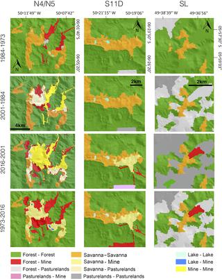
The eastern Brazilian Amazon contains many isolated ferruginous savanna ecosystem patches (locally known as ‘canga vegetation’) located on ironstone rocky outcrops on the top of plateaus and ridges, surrounded by tropical rainforests. In the Carajás Mineral Province (CMP), these outcrops contain large iron ore reserves that have been exploited by opencast mining since the 1980s. The canga vegetation is particularly impacted by mining, since the iron ores that occur are associated with this type of vegetation and currently, little is known regarding the extent of canga vegetation patches before mining activities began. This information is important for quantifying the impact of mining, in addition to helping plan conservation programmes. Here, land cover changes of the Canga area in the CMP are evaluated by estimating the pre-mining area of canga patches and comparing it to the actual extent of canga patches. We mapped canga vegetation using geographic object-based image analysis (GEOBIA) from 1973 Landsat-1 MSS, 1984 and 2001 Landsat-5 TM, and 2016 Landsat-8 OLI images, and found that canga vegetation originally occupied an area of 144.2 km2 before mining exploitation. By 2016, 19.6% of the canga area was lost in the CMP due to conversion to other land-use types (mining areas, pasturelands). In the Carajás National Forest (CNF), located within the CMP, the original canga vegetation covered 105.2 km2 (2.55% of the CNF total area), and in 2016, canga vegetation occupied an area of 77.2 km2 (1.87%). Therefore, after more than three decades of mineral exploitation, less than 20% of the total canga area was lost. Currently, 21% of the canga area in the CMP is protected by the Campos Ferruginosos National Park. By documenting the initial extent of canga vegetation in the eastern Amazon and the extent to which it has been lost due to mining operations, the results of this work are the first step towards conserving this ecosystem.
中文翻译:
巴西亚马逊河地区含铁露头热带稀树草原的制图和定量:生物多样性保护的挑战
巴西东部的亚马逊地区位于高原和山脊顶部的铁石岩石露头上,周围是热带雨林,周围有许多孤立的铁质热带稀树草原生态系统斑块(当地称为“高加索植被”)。在加拉加斯矿产省(CMP),这些露头含有大量铁矿石储量,自1980年代以来,这些铁矿石储量已被露天开采开采。由于开采出的铁矿石与这种类型的植被有关,因此特别是对高加索植被的影响很大,目前,人们对采矿活动开始之前的高加索植被斑块的程度知之甚少。除了帮助计划保护计划之外,该信息对于量化采矿的影响也很重要。这里,通过估算canga斑块的开采前面积并将其与canga斑块的实际范围进行比较,来评估CMP中Canga区域的土地覆盖变化。我们使用1973年Landsat-1 MSS,1984年和2001年Landsat-5 TM以及2016年Landsat-8 OLI图像基于地理对象的图像分析(GEOBIA)绘制了高加索植被图,发现高加索植被最初占地144.2 km2开采前要开采。到2016年,由于转化为其他土地利用类型(采矿区,牧场),CMP中损失了19.6%的加加地区。在CMP内的加拉加斯国家森林(CNF)中,原始的加加植被覆盖了105.2 km 2(占CNF总面积的2.55%),2016年,加加植被覆盖了77.2 km 2(1.87%)。因此,经过三十多年的矿产开采,流失的总嘎嘎面积不到20%。目前,CMP中21%的加加地区受到Campos Ferruginosos国家公园的保护。通过记录东部亚马逊河中的加贺植被的原始范围以及由于采矿作业造成的损失,该工作的结果是保护该生态系统的第一步。


 京公网安备 11010802027423号