Nature Reviews Earth & Environment ( IF 42.1 ) Pub Date : 2019-12-09 , DOI: 10.1038/s43017-019-0003-8 Jeroen Tromp
|
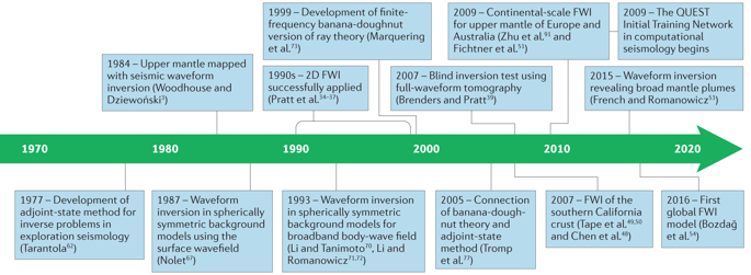
Seismic full-waveform inversion (FWI) for imaging Earth’s interior was introduced in the late 1970s. Its ultimate goal is to use all of the information in a seismogram to understand the structure and dynamics of Earth, such as hydrocarbon reservoirs, the nature of hotspots and the forces behind plate motions and earthquakes. Thanks to developments in high-performance computing and advances in modern numerical methods in the past 10 years, 3D FWI has become feasible for a wide range of applications and is currently used across nine orders of magnitude in frequency and wavelength. A typical FWI workflow includes selecting seismic sources and a starting model, conducting forward simulations, calculating and evaluating the misfit, and optimizing the simulated model until the observed and modelled seismograms converge on a single model. This method has revealed Pleistocene ice scrapes beneath a gas cloud in the Valhall oil field, overthrusted Iberian crust in the western Pyrenees mountains, deep slabs in subduction zones throughout the world and the shape of the African superplume. The increased use of multi-parameter inversions, improved computational and algorithmic efficiency, and the inclusion of Bayesian statistics in the optimization process all stand to substantially improve FWI, overcoming current computational or data-quality constraints. In this Technical Review, FWI methods and applications in controlled-source and earthquake seismology are discussed, followed by a perspective on the future of FWI, which will ultimately result in increased insight into the physics and chemistry of Earth’s interior.
中文翻译:
跨尺度地球内部的地震波场成像
1970年代后期推出了用于对地球内部成像的地震全波形反演(FWI)。它的最终目标是利用地震图中的所有信息来了解地球的结构和动力学,例如碳氢化合物储层,热点的性质以及板块运动和地震背后的作用力。得益于过去10年高性能计算的发展和现代数值方法的发展,3D FWI已在广泛的应用中变得可行,并且目前在频率和波长的九个数量级中使用。典型的FWI工作流程包括选择地震源和初始模型,进行正演模拟,计算和评估失配以及优化模拟模型,直到观测到的地震图和建模的地震图收敛到单个模型上为止。该方法揭示了瓦尔霍尔油田气云下的更新世冰屑,比利牛斯山脉西部的伊比利亚地壳上倾,全世界俯冲带中的深厚板块以及非洲超级软岩的形状。多参数反演的增加使用,改进的计算和算法效率,以及在优化过程中包含贝叶斯统计信息,都可以从根本上改善FWI,从而克服当前的计算或数据质量约束。在本技术评论中,将讨论FWI方法及其在可控震源和地震地震学中的应用,然后对FWI的未来进行展望,最终将使人们对地球内部的物理和化学有更深入的了解。


 京公网安备 11010802027423号