Science of the Total Environment ( IF 9.8 ) Pub Date : 2019-05-17 , DOI: 10.1016/j.scitotenv.2019.05.194 G. de Bouchard d'Aubeterre , A. Favillier , R. Mainieri , J. Lopez Saez , N. Eckert , M. Saulnier , J.-L. Peiry , M. Stoffel , C. Corona
|
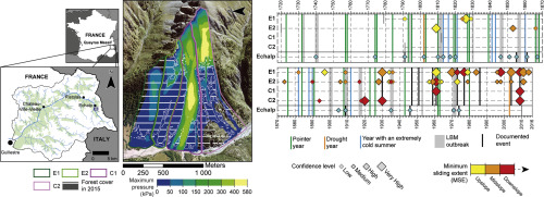
In the current context of anthropogenic global warming, one of the purposes of dendrogeomorphic analyses is to provide long and continuous chronologies of mass movements, so as to detect potential trends or shift related to increasing temperatures. However, on documented slopes, the comparison between historical archives and tree-ring records suggests that dendrogeomorphic reconstructions systematically underestimate the natural activity of the process under investigation. In the specific case of snow avalanches, underestimation generally amounts to 50% and the main causes generally given for this difference are related to the magnitude of past events. In this study, we hypothesize that the morphometric characteristics of avalanche paths and their forest cover could have significant impacts on the length and reliability of tree-ring reconstructions. In order to test this hypothesis, we selected four adjacent, albeit differently structured, avalanche paths from the Queyras massif (French Alps), with the aim to compare their potential for a continuous reconstruction of past avalanche activity. On the most active avalanche paths characterized by high-altitude release areas (covered only by shrubby vegetation), tree-ring reconstructions do not exceed one century in length, with recurrence intervals of high magnitude events >25 years. By contrast, on forested couloirs where lower slopes and forest coverage up to the release areas limits the intensity of events, the frequency of reconstructed snow avalanches is 2.5 times higher, the reconstructions span longer periods and the convergence rate with historical archives attest to the reliability of the dendrogeomorphic approach. These results suggest that a careful selection of couloirs is essential and that priority should be given to forested sites as (i) they allow for exhaustive and (ii) reliable reconstructions over (iii) long periods of time.
中文翻译:
雪环活动的树环重建:雪崩路径选择重要吗?
在当前的人为全球变暖的背景下,树状地貌分析的目的之一是提供长期连续的质量运动时间顺序,以便发现与温度升高相关的潜在趋势或变化。然而,在有记录的斜坡上,历史档案和树木年轮记录之间的比较表明,树状地貌重建系统地低估了所研究过程的自然活动。在雪崩的特殊情况下,低估通常达到50%,而造成这种差异的主要原因通常与过去发生的事件有关。在这项研究中,我们假设雪崩路径的形态特征及其森林覆盖率可能对树环重建的长度和可靠性产生重大影响。为了检验该假设,我们从Queyras断层(法国阿尔卑斯山)中选择了四个相邻的,尽管结构不同的雪崩路径,目的是比较它们连续重建过去雪崩活动的潜力。在以高空释放区(仅由灌木丛植被覆盖)为特征的最活跃的雪崩路径上,树环重建的长度不超过一个世纪,高强度事件的复发间隔大于25年。相比之下,在坡度较低且森林覆盖率高至释放区的森林小流浪者中,事件的强度受到限制,重建雪崩的频率高出2.5倍,重建跨越更长的时间,历史档案的收敛速度证明了树状地貌方法的可靠性。这些结果表明,精心选择古卢尔是至关重要的,应优先考虑林地,因为(i)它们允许在(iii)长时间内进行详尽和(ii)可靠的重建。


 京公网安备 11010802027423号