Precision Agriculture ( IF 6.2 ) Pub Date : 2023-04-25 , DOI: 10.1007/s11119-023-10021-z Mitsuru Hamano , Shigeru Shiozawa , Shinya Yamamoto , Noritsugu Suzuki , Yuichiro Kitaki , Osamu Watanabe
|
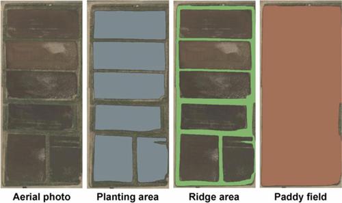
In Japan, mowing work on ridges of farms that cultivate rice is difficult for farmers, especially in hilly and mountainous areas. Moreover, geographical information on ridges in paddy fields has not been prepared; such information includes the slope angle, the ridge area, and the ridge rate of the total paddy field area. This issue causes a level of uncertainty in management analysis in terms of labor costs, including mowing costs, particularly when farmers and agricultural corporations are starting or expanding farm businesses. Therefore, this research developed a method for creating planting area and ridge area polygons in paddy fields to measure the actual areas of both sites using slope angle information and calculating the ridge rates in paddy fields. This study adopts artificial intelligence, geographical information system (GIS), and precision digital elevation model techniques as strategy implementation tools with data prepared by an aerial laser survey of Nagano Prefecture. The model generated using the proposed machine learning tool can automatically detect the planting and ridge areas of paddy fields through aerial images of farmland with more than 96% accuracy. Then, polygons can be created for use in GIS. Furthermore, these polygons can be created for most of the understudied paddy fields, approximately 35 000 hectares throughout Nagano Prefecture, in only 2 to 3 weeks. Therefore, based on these techniques, the slope angles of ridges, the ridge areas, and the ridge rates of paddy areas can be measured through polygons.
中文翻译:
基于人工智能、地理信息系统和精确 DEM 的水田种植和垄区检测方法的开发
在日本,种植水稻的农场的垄上割草对农民来说很困难,尤其是在丘陵和山区。此外,还没有准备好稻田垄的地理信息;这些信息包括整个水田面积的坡度、垄面积和垄率。这个问题导致在劳动力成本方面的管理分析存在一定程度的不确定性,包括割草成本,特别是当农民和农业公司开始或扩大农场业务时。因此,本研究开发了一种在水田中创建种植区和垄区多边形的方法,以使用倾斜角信息测量两个地点的实际面积并计算稻田的垄率。本研究采用人工智能、地理信息系统(GIS)、和精密数字高程模型技术作为战略实施工具,使用长野县航空激光测量准备的数据。使用所提出的机器学习工具生成的模型可以通过农田航拍图像自动检测水田的种植和垄区,准确率超过 96%。然后,可以创建用于 GIS 的多边形。此外,只需 2 到 3 周,就可以为大部分未被充分研究的稻田(整个长野县约 35,000 公顷)创建这些多边形。因此,基于这些技术,可以通过多边形测量垄的倾斜角、垄的面积和水田的垄率。使用所提出的机器学习工具生成的模型可以通过农田航拍图像自动检测水田的种植和垄区,准确率超过 96%。然后,可以创建用于 GIS 的多边形。此外,只需 2 到 3 周,就可以为大部分未被充分研究的稻田(整个长野县约 35,000 公顷)创建这些多边形。因此,基于这些技术,可以通过多边形测量垄的倾斜角、垄的面积和水田的垄率。使用所提出的机器学习工具生成的模型可以通过农田航拍图像自动检测水田的种植和垄区,准确率超过 96%。然后,可以创建用于 GIS 的多边形。此外,只需 2 到 3 周,就可以为大部分未被充分研究的稻田创建这些多边形,整个长野县的稻田面积约为 35,000 公顷。因此,基于这些技术,可以通过多边形测量垄的倾斜角、垄的面积和水田的垄率。这些多边形可以在 2 到 3 周内为大部分未被研究的稻田创建,整个长野县的稻田面积约为 35,000 公顷。因此,基于这些技术,可以通过多边形测量垄的倾斜角、垄的面积和水田的垄率。这些多边形可以在 2 到 3 周内为大部分未被研究的稻田创建,整个长野县的稻田面积约为 35,000 公顷。因此,基于这些技术,可以通过多边形测量垄的倾斜角、垄的面积和水田的垄率。


 京公网安备 11010802027423号