Mineralium Deposita ( IF 4.8 ) Pub Date : 2022-12-03 , DOI: 10.1007/s00126-022-01153-9 David L. Huston , David C. Champion , Karol Czarnota , Jingming Duan , Matthew Hutchens , Suzanne Paradis , Mark Hoggard , Bryant Ware , George M. Gibson , Michael P. Doublier , Karen Kelley , Anne McCafferty , Nathan Hayward , Fred Richards , Svetlana Tessalina , Graham Carr
|
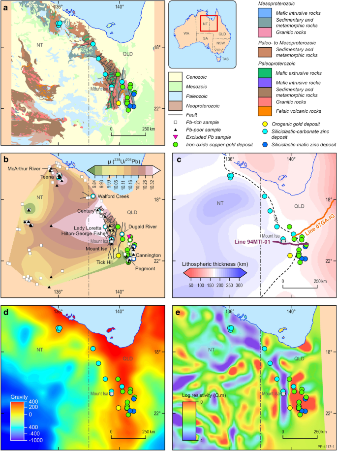
The North Australian Zinc Belt is the largest zinc-lead province in the world, containing three of the ten largest known individual deposits (HYC, Hilton-George Fisher, and Mount Isa). The Northern Cordillera in North America is the second largest zinc-lead province, containing a further two of the world’s top ten deposits (Red Dog and Howards Pass). Despite this world-class endowment, exploration in both mineral provinces during the past 2 decades has not been particularly successful, yielding only two significant discoveries (Teena, Australia, and Boundary, Canada). One of the most important aspects of exploration is to choose mineral provinces and districts within geological belts that have the greatest potential for discovery. Here, we present results from these two zinc belts that highlight previously unused datasets for area selection and targeting. Lead isotope mapping using analyses of mineralized material has identified gradients in μ (238U/204Pb) that coincide closely with many major deposits. Locations of these deposits also coincide with a gradient in the depth of the lithosphere-asthenosphere boundary determined from calibrated surface wave tomography models converted to temperature. Furthermore, gradients in upward-continued gravity anomalies and a step in Moho depth correspond to a pre-existing major crustal boundary in both zinc belts. A spatial association of deposits with a linear mid- to lower-crustal resistivity anomaly from magnetotelluric data is also observed in the North Australian Zinc Belt. The change from thicker to thinner lithosphere is interpreted to localize prospective basins for zinc-lead mineralization and to control the gradient in lead isotope and geophysical data. These data, when combined with data indicative of paleoenvironment and changes in plate motion at the time of mineralization, provide new exploration criteria that can be used to identify prospective mineralized basins and define the most favorable parts of these basins.
中文翻译:
边缘的锌——克拉通边缘控制世界级页岩锌铅矿床的同位素和地球物理学证据
北澳大利亚锌带是世界上最大的锌铅矿产区,包含十大已知独立矿床中的三个(HYC、Hilton-George Fisher 和 Mount Isa)。北美洲的北科迪勒拉山脉是第二大锌铅省份,拥有世界十大矿床中的另外两个(Red Dog 和 Howards Pass)。尽管拥有世界一流的禀赋,但过去 20 年在这两个矿产省份的勘探并不是特别成功,仅产生了两个重大发现(澳大利亚蒂纳和加拿大边界)。勘探最重要的方面之一是在地质带内选择发现潜力最大的矿产省区。这里,我们展示了这两个锌带的结果,这些结果突出显示了以前未使用的区域选择和定位数据集。使用矿化材料分析的铅同位素映射已经确定了 μ (238单位/ 204Pb) 与许多主要矿床紧密重合。这些矿床的位置也与岩石圈-软流圈边界深度的梯度一致,该边界由转换为温度的校准表面波断层扫描模型确定。此外,向上连续重力异常的梯度和莫霍面深度的阶梯对应于两条锌带中预先存在的主要地壳边界。在北澳大利亚锌带中也观察到沉积物与来自大地电磁数据的线性中低地壳电阻率异常的空间关联。岩石圈从厚到薄的变化被解释为定位锌铅矿化的预期盆地,并控制铅同位素和地球物理数据的梯度。这些数据,


 京公网安备 11010802027423号