Nature ( IF 64.8 ) Pub Date : 2022-09-26 , DOI: 10.1038/s41586-022-05147-5 Chao Li 1 , Yikang Zheng 2 , Xin Wang 1 , Jinhai Zhang 1 , Yibo Wang 2, 3 , Ling Chen 3, 4 , Lei Zhang 1 , Pan Zhao 4 , Yike Liu 2 , Wenmin Lv 1 , Yang Liu 5, 6 , Xu Zhao 1 , Jinlai Hao 1 , Weijia Sun 1 , Xiaofeng Liu 7 , Bojun Jia 7 , Juan Li 1, 3 , Haiqiang Lan 4 , Wenzhe Fa 7 , Yongxin Pan 1, 3 , Fuyuan Wu 3, 4
|
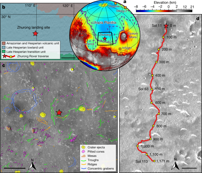
Exploring the subsurface structure and stratification of Mars advances our understanding of Martian geology, hydrological evolution and palaeoclimatic changes, and has been a main task for past and continuing Mars exploration missions1,2,3,4,5,6,7,8,9,10. Utopia Planitia, the smooth plains of volcanic and sedimentary strata that infilled the Utopia impact crater, has been a prime target for such exploration as it is inferred to have hosted an ancient ocean on Mars11,12,13. However, 45 years have passed since Viking-2 provided ground-based detection results. Here we report an in situ ground-penetrating radar survey of Martian subsurface structure in a southern marginal area of Utopia Planitia conducted by the Zhurong rover of the Tianwen-1 mission. A detailed subsurface image profile is constructed along the roughly 1,171 m traverse of the rover, showing an approximately 70-m-thick, multi-layered structure below a less than 10-m-thick regolith. Although alternative models deserve further scrutiny, the new radar image suggests the occurrence of episodic hydraulic flooding sedimentation that is interpreted to represent the basin infilling of Utopia Planitia during the Late Hesperian to Amazonian. While no direct evidence for the existence of liquid water was found within the radar detection depth range, we cannot rule out the presence of saline ice in the subsurface of the landing area.
中文翻译:
祝融火星车雷达揭示火星乌托邦盆地地下层状结构
探索火星的地下结构和分层有助于我们了解火星地质、水文演化和古气候变化,并且一直是过去和持续的火星探索任务的主要任务1,2,3,4,5,6,7,8, 9,10。乌托邦平原是充满乌托邦撞击坑的火山和沉积地层的光滑平原,一直是此类探索的主要目标,因为据推测它在火星上拥有一个古老的海洋11,12,13. 然而,距离维京二号提供地面探测结果已经过去了 45 年。在这里,我们报告了由天问一号任务的祝融火星车对乌托邦平原南部边缘地区的火星地下结构进行的原位探地雷达调查。详细的地下图像轮廓是沿着漫游者大约 1,171 米的横断面构建的,显示了在不到 10 米厚的风化层下面有一个大约 70 米厚的多层结构。尽管替代模型值得进一步审查,但新的雷达图像表明发生了间歇性水力泛滥沉积,这被解释为代表晚希斯伯利亚到亚马逊纪期间 Utopia Planitia 的盆地充填。虽然在雷达探测深度范围内没有发现液态水存在的直接证据,


 京公网安备 11010802027423号