当前位置:
X-MOL 学术
›
Geolog. J.
›
论文详情
Our official English website, www.x-mol.net, welcomes your feedback! (Note: you will need to create a separate account there.)
Landslide susceptibility mapping of Noklak Town, Nagaland, North-east India using bivariate statistical method
Geological Journal ( IF 1.8 ) Pub Date : 2022-09-25 , DOI: 10.1002/gj.4595 Mademshila Jamir 1 , Chongpongnungba Nokendangba Chang 1 , Imlirenla Jamir 2 , Glenn T. Thong 1 , Temsulemba Walling 1
Geological Journal ( IF 1.8 ) Pub Date : 2022-09-25 , DOI: 10.1002/gj.4595 Mademshila Jamir 1 , Chongpongnungba Nokendangba Chang 1 , Imlirenla Jamir 2 , Glenn T. Thong 1 , Temsulemba Walling 1
Affiliation
|
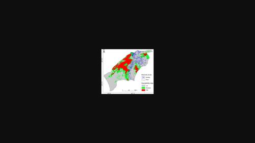
The increasing frequency of landslides has become a matter of concern in Nagaland, a north-eastern state of India. Noklak town, the administrative headquarter of the Noklak district in the eastern part of Nagaland bordering Myanmar, is also affected by slope stability issues. A major landslide in 1980 caused major damage to parts of the township. The problem has grown in magnitude and influence over the last four decades, damaging an area of about 1.84 km2 and several households. Slope movements have caused immense distress to the local populace by posing a constant threat to nearly one-fourth of the town's built-up area, roads, and cultivated tracts. Surface instability has also hampered India's Act East policy with South-east Asian countries by disrupting the sole motorable route to the International Trade Centre at Dan (Pangsha), between India and Myanmar. A landslide susceptibility map (LSM) was generated using the Bivariate Yule coefficient (Yc) method. The LSM delineates the study area into three categories, with 23%, 23%, and 54% in high, moderate, and low susceptible zones, respectively. This was superimposed with elements such as buildings, population, roads, and cultivated tracts to assess the effects of landslides on the population and infrastructure. From the present study, it is estimated that 334 buildings, 1235 people, 2.99 km of roads, and 8 ha of cultivated landfall lie within the moderately and highly susceptible zones. Considering the rapid developmental activities that will ensue with the recent upgradation of the subdivision to that of the district, the data generated will be useful for urban sprawl and land use planning, to minimise and mitigate the loss of life and property due to landslides.
中文翻译:

使用双变量统计方法绘制印度东北部那加兰邦 Noklak 镇的滑坡敏感性图
在印度东北部的那加兰邦,越来越频繁的山体滑坡已经成为一个令人担忧的问题。与缅甸接壤的那加兰邦东部诺克拉克区的行政总部诺克拉克镇也受到边坡稳定性问题的影响。1980 年的一次重大山体滑坡对该镇的部分地区造成了重大破坏。在过去的四十年里,这个问题的严重性和影响力都在增加,破坏了大约 1.84 平方公里的区域2和几户人家。斜坡运动给当地民众带来了极大的痛苦,因为该镇近四分之一的建成区、道路和耕地一直受到威胁。地表不稳定还阻碍了印度与东南亚国家的“东进”政策,因为它扰乱了通往印度和缅甸之间丹(邦沙)国际贸易中心的唯一机动车道。使用双变量 Yule 系数 (Yc) 方法生成滑坡敏感性图 (LSM)。LSM 将研究区域划分为三类,高、中、低易感区分别占 23%、23% 和 54%。这与建筑物、人口、道路和耕地等要素叠加,以评估山体滑坡对人口和基础设施的影响。从目前的研究来看,据估计,334 栋建筑物、1235 人、2.99 公里的道路和8 公顷的耕地位于中度和高度易感区。考虑到最近将细分升级为地区的快速发展活动,生成的数据将有助于城市扩张和土地利用规划,以最大限度地减少和减轻山体滑坡造成的生命和财产损失。
更新日期:2022-09-25
中文翻译:
使用双变量统计方法绘制印度东北部那加兰邦 Noklak 镇的滑坡敏感性图
在印度东北部的那加兰邦,越来越频繁的山体滑坡已经成为一个令人担忧的问题。与缅甸接壤的那加兰邦东部诺克拉克区的行政总部诺克拉克镇也受到边坡稳定性问题的影响。1980 年的一次重大山体滑坡对该镇的部分地区造成了重大破坏。在过去的四十年里,这个问题的严重性和影响力都在增加,破坏了大约 1.84 平方公里的区域2和几户人家。斜坡运动给当地民众带来了极大的痛苦,因为该镇近四分之一的建成区、道路和耕地一直受到威胁。地表不稳定还阻碍了印度与东南亚国家的“东进”政策,因为它扰乱了通往印度和缅甸之间丹(邦沙)国际贸易中心的唯一机动车道。使用双变量 Yule 系数 (Yc) 方法生成滑坡敏感性图 (LSM)。LSM 将研究区域划分为三类,高、中、低易感区分别占 23%、23% 和 54%。这与建筑物、人口、道路和耕地等要素叠加,以评估山体滑坡对人口和基础设施的影响。从目前的研究来看,据估计,334 栋建筑物、1235 人、2.99 公里的道路和8 公顷的耕地位于中度和高度易感区。考虑到最近将细分升级为地区的快速发展活动,生成的数据将有助于城市扩张和土地利用规划,以最大限度地减少和减轻山体滑坡造成的生命和财产损失。


 京公网安备 11010802027423号