当前位置:
X-MOL 学术
›
Int. J. Climatol.
›
论文详情
Our official English website, www.x-mol.net, welcomes your feedback! (Note: you will need to create a separate account there.)
Innovative polygon trend analysis of monthly precipitation (1952–2015) in the Hindukush-Karakoram-Himalaya river basins of Pakistan
International Journal of Climatology ( IF 3.9 ) Pub Date : 2022-09-20 , DOI: 10.1002/joc.7875 Naveed Ahmed 1 , Haishen Lu 1 , Martijn J. Booij 2 , Genxu Wang 3 , Hero Marhaento 4 , Mohd Sultan Bhat 5 , Shahzada Adnan 6
International Journal of Climatology ( IF 3.9 ) Pub Date : 2022-09-20 , DOI: 10.1002/joc.7875 Naveed Ahmed 1 , Haishen Lu 1 , Martijn J. Booij 2 , Genxu Wang 3 , Hero Marhaento 4 , Mohd Sultan Bhat 5 , Shahzada Adnan 6
Affiliation
|
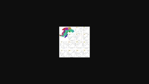
The Hindukush-Karakoram-Himalayas (HKH) mountainous range supplies water to 10 river basins serving eight countries. The present study focuses on the river basins located within the HKH region in Pakistan. The modified Soil and Water Assessment Tool (SWAT+) was used to split the research region into 13 sub-basins. The Mann–Kendall, Sen's slope, innovative polygon trend analysis (IPTA), and innovative trend analysis (ITA) methods were used for the monthly precipitation time series. The Shyok sub-basin (central Karakoram) experienced rising trends for all seasons, while the southwestern Karakoram (Hunza) showed a rising trend only for the winter. The Hindukush Mountain Range feeds five sub-basins (Gilgit, Chitral, Swat, Kabul, and Kurram). The Gilgit and Kurram sub-basins observed an upward trend for all seasons. A falling trend in spring and transition from spring (falling) to summer (rising) was observed for the Swat and Kabul sub-basins. The Chitral sub-basin received rising precipitation in spring, summer, and autumn, whereas no trend was observed during winter. In the southern Himalayas (Kanshi and Jhelum), no trend was observed in winter and autumn and a falling trend in spring and summer. The Kunhar sub-basin (southern Himalaya) showed rising trends in winter, spring, and autumn. In contrast, the Soan sub-basin (eastern Himalaya) has no trend in spring, and other seasons show rising trends. The sub-basin Upper Indus experienced a rising trend for autumn, winter, and summer, while a downward trend was observed in spring. The IPTA and ITA approaches are much more sensitive than the Mann–Kendall method in detecting trends. Although the innovative methods are mostly compatible with each other (90%), the IPTA presents additional information about trend transitions between successive parts of the time series. The results presented in this study are an advancement in the investigations made so far in this region and will help to understand the climate and hydrology of this region.
中文翻译:

巴基斯坦兴都库什-喀喇昆仑-喜马拉雅河流域月降水量(1952-2015)创新多边形趋势分析
兴都库什-喀喇昆仑-喜马拉雅山 (HKH) 山脉为服务于 8 个国家的 10 个河流流域供水。本研究的重点是位于巴基斯坦 HKH 地区的河流流域。修改后的水土评估工具 (SWAT+) 用于将研究区域划分为 13 个子流域。Mann–Kendall、Sen 斜率、创新多边形趋势分析 (IPTA) 和创新趋势分析 (ITA) 方法用于每月降水时间序列。Shyok 子流域(喀喇昆仑中部)全年呈上升趋势,而西南喀喇昆仑(罕萨)仅在冬季呈上升趋势。兴都库什山脉为五个次级盆地(吉尔吉特、奇特拉尔、斯瓦特、喀布尔和库拉姆)供水。吉尔吉特和库拉姆子流域观察到所有季节都呈上升趋势。在斯瓦特和喀布尔子流域观察到春季下降趋势和从春季(下降)到夏季(上升)的过渡。Chitral 子流域在春季、夏季和秋季的降水量增加,而冬季没有观察到趋势。喜马拉雅山南部(坎什、杰赫勒姆)冬秋季无变化趋势,春夏季有下降趋势。Kunhar 子流域(喜马拉雅南部)在冬季、春季和秋季呈现上升趋势。相比之下,索安次盆地(喜马拉雅东部)春季无变化趋势,其他季节均呈上升趋势。上梧桐子流域秋、冬、夏呈上升趋势,春季呈下降趋势。IPTA 和 ITA 方法在检测趋势方面比 Mann-Kendall 方法灵敏得多。尽管创新方法大多相互兼容 (90%),但 IPTA 提供了有关时间序列连续部分之间趋势转换的额外信息。本研究提出的结果是该地区迄今为止所做调查的进步,将有助于了解该地区的气候和水文。
更新日期:2022-09-20
中文翻译:
巴基斯坦兴都库什-喀喇昆仑-喜马拉雅河流域月降水量(1952-2015)创新多边形趋势分析
兴都库什-喀喇昆仑-喜马拉雅山 (HKH) 山脉为服务于 8 个国家的 10 个河流流域供水。本研究的重点是位于巴基斯坦 HKH 地区的河流流域。修改后的水土评估工具 (SWAT+) 用于将研究区域划分为 13 个子流域。Mann–Kendall、Sen 斜率、创新多边形趋势分析 (IPTA) 和创新趋势分析 (ITA) 方法用于每月降水时间序列。Shyok 子流域(喀喇昆仑中部)全年呈上升趋势,而西南喀喇昆仑(罕萨)仅在冬季呈上升趋势。兴都库什山脉为五个次级盆地(吉尔吉特、奇特拉尔、斯瓦特、喀布尔和库拉姆)供水。吉尔吉特和库拉姆子流域观察到所有季节都呈上升趋势。在斯瓦特和喀布尔子流域观察到春季下降趋势和从春季(下降)到夏季(上升)的过渡。Chitral 子流域在春季、夏季和秋季的降水量增加,而冬季没有观察到趋势。喜马拉雅山南部(坎什、杰赫勒姆)冬秋季无变化趋势,春夏季有下降趋势。Kunhar 子流域(喜马拉雅南部)在冬季、春季和秋季呈现上升趋势。相比之下,索安次盆地(喜马拉雅东部)春季无变化趋势,其他季节均呈上升趋势。上梧桐子流域秋、冬、夏呈上升趋势,春季呈下降趋势。IPTA 和 ITA 方法在检测趋势方面比 Mann-Kendall 方法灵敏得多。尽管创新方法大多相互兼容 (90%),但 IPTA 提供了有关时间序列连续部分之间趋势转换的额外信息。本研究提出的结果是该地区迄今为止所做调查的进步,将有助于了解该地区的气候和水文。


 京公网安备 11010802027423号