Precision Agriculture ( IF 6.2 ) Pub Date : 2022-08-30 , DOI: 10.1007/s11119-022-09956-6 L. Sandonís-Pozo , J. Llorens , A. Escolà , J. Arnó , M. Pascual , J. A. Martínez-Casasnovas
|
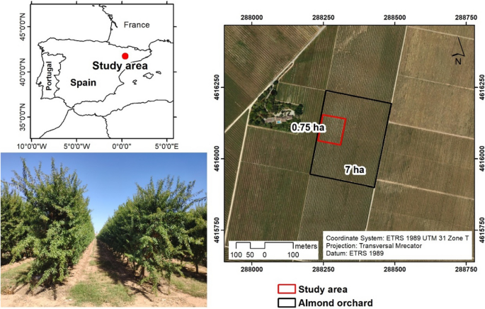
Continuous canopy status monitoring is an essential factor to support and precisely apply orchard management actions such as pruning, pesticide and foliar treatment applications, or fertirrigation, among others. For that, this work proposes the use of multispectral vegetation indices to estimate geometric and structural orchard parameters from remote sensing images (high temporal and spatial resolution) as an alternative to more time-consuming processing techniques, such as LiDAR surveys or UAV photogrammetry. A super-intensive almond (Prunus dulcis) orchard was scanned using a mobile terrestrial laser (LiDAR) in two different vegetative stages (after spring pruning and before harvesting). From the LiDAR point cloud, canopy orchard parameters, including maximum height and width, cross-sectional area and porosity, were summarized every 0.5 m along the rows and interpolated using block kriging to the pixel centroids of PlanetScope (3 × 3 m) and Sentinel-2 (10 × 10 m) image grids. To study the association between the LiDAR-derived parameters and 4 different vegetation indices. A canonical correlation analysis was carried out, showing the normalized difference vegetation index (NDVI) and the green normalized difference vegetation index (GNDVI) to have the best correlations. A cluster analysis was also performed. Results can be considered optimistic both for PlanetScope and Sentinel-2 images to delimit within-field management zones, being supported by significant differences in LiDAR-derived canopy parameters.
中文翻译:
卫星多光谱指数估计超密集杏仁园的冠层参数和田间管理区
持续的冠层状态监测是支持和精确应用果园管理行动的重要因素,如修剪、杀虫剂和叶面处理应用或施肥等。为此,这项工作建议使用多光谱植被指数从遥感图像(高时间和空间分辨率)估计几何和结构果园参数,以替代更耗时的处理技术,如 LiDAR 调查或无人机摄影测量。超级密集的杏仁(Prunus dulcis) 使用移动地面激光 (LiDAR) 在两个不同的植物生长阶段(春季修剪后和收获前)对果园进行扫描。从 LiDAR 点云,树冠果园参数,包括最大高度和宽度、横截面积和孔隙率,沿行每 0.5 m 汇总一次,并使用块克里金法插值到 PlanetScope (3 × 3 m) 和 Sentinel 的像素质心-2 (10 × 10 m) 图像网格。研究 LiDAR 衍生参数与 4 种不同植被指数之间的关联。进行了典型相关分析,显示归一化差异植被指数(NDVI)和绿色归一化差异植被指数(GNDVI)具有最佳相关性。还进行了聚类分析。


 京公网安备 11010802027423号