Precision Agriculture ( IF 6.2 ) Pub Date : 2022-08-29 , DOI: 10.1007/s11119-022-09948-6 L. N. Lacerda , J. Snider , Y. Cohen , V. Liakos , M. R. Levi , G. Vellidis
|
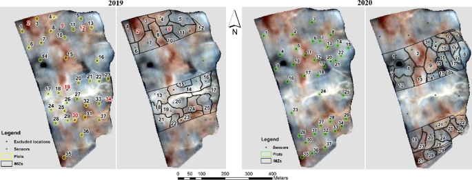
Current irrigation management zones (IMZs) for variable rate irrigation (VRI) systems are static. They are delineated in the beginning of the season and used thereafter. However, recent research has shown that IMZ boundaries are transient and change with time during the growing season. The primary goal of this study was to explore the potential of using vegetation indices (VIs) developed from unmanned aerial vehicle (UAV) and satellite images to predict cotton physiological parameters that can be used to delineate in-season boundaries of IMZs. A 2 year study was conducted in a 38 ha commercial cotton field in southwestern Georgia, USA. Throughout the two growing seasons, VIs were calculated from UAV, PlanetScope, and Sentinel-2 images. Predawn leaf water potential (LWPPD) and plant height were measured at 37 locations in the field on the same day as the flights and correlated with UAV and satellite based-VIs. GNDVI (Green normalized difference vegetation index) was the best predictor of plant height with correlation values of 0.72 (p < .0001) and 0.84 (p < .0001) for 2019 and 2020, respectively. A secondary goal was to compare the performance of dynamic VRI (DVRI) to conventional irrigation. The field was divided into alternating parallel conventional, and DVRI strips to compare the two scheduling methods. The conventional strips were irrigated using the farmer’s standard method and individual IMZs within the DVRI strips were irrigated based on soil water tension (SWT) measured with a wireless soil moisture sensor network. LWP and SWT measurements correlated well. IMZs were initially delineated using soil texture, apparent soil electrical conductivity (ECa), and yield maps and satellite images from previous years and were modified in-season to reflect patterns observed in the plant height maps. In 2020, the DVRI system prescribed an average irrigation amount of 50.8 mm while conventional irrigation applied an average of 58.4 mm. Average yields for DVRI and conventional were 1248 and 1191 kg ha−1, respectively. The DVRI system resulted in average yield 4.6% higher than conventional irrigation, while applying 14.0% less water. Despite the lower water application by the DRVI system, the performance comparison between the DRVI and the conventional irrigation was not conclusive.
中文翻译:
无人机和卫星衍生的植被指数与棉花生理参数的相关性及其作为棉花可变速率灌溉调度工具的应用
当前用于可变速率灌溉 (VRI) 系统的灌溉管理区 (IMZ) 是静态的。它们在赛季开始时被划定并在之后使用。然而,最近的研究表明,IMZ 边界是短暂的,并且在生长季节随时间变化。本研究的主要目的是探索利用无人机 (UAV) 和卫星图像开发的植被指数 (VI) 来预测可用于描绘 IMZ 季节边界的棉花生理参数的潜力。在美国佐治亚州西南部一个 38 公顷的商业棉田中进行了一项为期 2 年的研究。在两个生长季节,VI 是根据 UAV、PlanetScope 和 Sentinel-2 图像计算得出的。黎明前叶水势(LWP PD) 和植物高度在飞行的同一天在现场的 37 个位置进行测量,并与无人机和基于卫星的 VI 相关联。GNDVI(绿色归一化植被指数)是植物高度的最佳预测因子,2019 年和 2020 年的相关值分别为 0.72(p < .0001)和 0.84(p < .0001)。第二个目标是比较动态 VRI (DVRI) 与传统灌溉的性能。该领域分为交替并行常规和DVRI条带来比较两种调度方法。使用农民的标准方法灌溉常规条带,并根据使用无线土壤湿度传感器网络测量的土壤水分张力 (SWT) 灌溉 DVRI 条带内的各个 IMZ。LWP 和 SWT 测量值相关性很好。IMZ 最初是使用土壤质地、表观土壤电导率 (ECa) 以及前几年的产量图和卫星图像来描绘的,并在季节进行了修改以反映在植物高度图中观察到的模式。2020 年,DVRI 系统规定的平均灌溉量为 50.8 毫米,而传统灌溉平均为 58.4 毫米。DVRI 和常规的平均单产分别为 1248 和 1191 公斤公顷-1,分别。DVRI 系统的平均产量比传统灌溉高 4.6%,而用水量减少了 14.0%。尽管 DRVI 系统的用水量较低,但 DRVI 与传统灌溉之间的性能比较尚无定论。


 京公网安备 11010802027423号