Bulletin of Engineering Geology and the Environment ( IF 4.2 ) Pub Date : 2022-08-02 , DOI: 10.1007/s10064-022-02845-2 Dawei Zhou , Ling Wang , Shikai An , Xiaopeng Wang , Yufei An
|
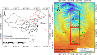
A method of monitoring the surface mining subsidence basin (SMSB) by integrating unmanned aerial vehicle (UAV) photogrammetry and interferometric synthetic aperture radar (InSAR) technology is proposed in this paper. In this method, subsidence with a small deformation gradient was calculated by InSAR, whereas large-scale subsidence was calculated by UAV photogrammetry technology. And then, the two types of data were fused through Kriging interpolation to obtain a complete and high-precision SMSB. Based on this fusion method, the dynamic surface subsidence induced by the mining of the 2S201 working face of Wangjiata coal mine in Inner Mongolia, China, was obtained by using the two phases of UAV images collected on June 9, 2018, and September 4, 2018, and the 8 SAR images of Sentinel-1A taken during this period. The results showed that the maximum subsidence extracted by the fusion method was 2.487 m. The accuracy of this method was evaluated by the data of 15 ground observation stations, measured by total station, and the root mean squared error (RMSE) of subsidence was 0.095 m. Finally, through the dynamic inversion method of mining subsidence parameters (MSP), a more reliable MSP is acquired, in which q was 0.72 and tan β was 1.9. UAV/InSAR integration technology provides a new technical approach to solving the monitoring problem of geological environment damage induced by large-scale and high-intensity mining and has a good prospect of application.


 京公网安备 11010802027423号