Applied Water Science ( IF 5.5 ) Pub Date : 2022-08-02 , DOI: 10.1007/s13201-022-01742-z Javad Rabiei, Mahboube Sadat Khademi, Sahar Bagherpour, Negin Ebadi, Akram Karimi, Kaveh Ostad-Ali-Askari
|
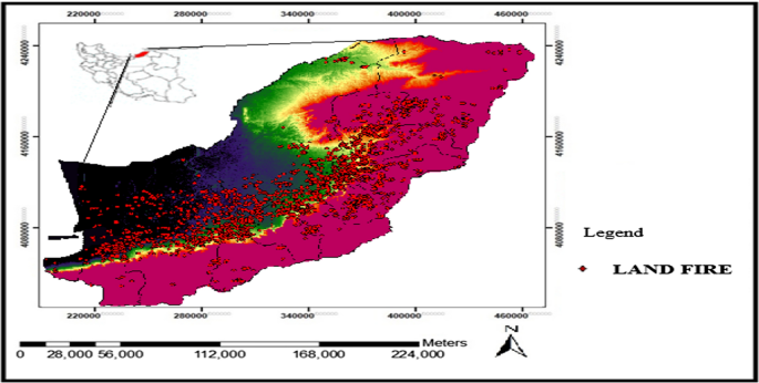
Forest fires destroy these areas and have devastating and harmful socio-economic and environmental effects. One of the methods of preventing and managing the hazards created in the field of forest fires is to determine the range of fire risk. The purpose of this study is to determine the high-risk areas of fire in the forests of Golestan province using remote sensing data and field information. For this purpose, the data of MODIS satellite during the years 2005 to 2020 for the middle of November to mid-February, which is the peak of the fire occurrence, were prepared. (NDVI) vegetation index, (NDMI) plant moisture stress index and (LST) land surface temperature were extracted as a 15-year average in these months. Then, using precipitation data from meteorological stations, precipitation index (SPI) was calculated as an average to estimate the amount of drought for the mentioned years. By combining the mentioned indices, the areas with fire risk were extracted. Then, previous fire reference data were used to validate the obtained results of the study. The results of fire potential map evaluation showed that about 6.39% of the area has very high potential, indicating that about 65.78% of fire risk points have been located in this area and about 56.32% of the area is in moderate-fire-risk position, encompassing about 23.16% of the areas with fire risk. Finally, a low-risk zone encompassing 36.34% of the area, which about 11.06% of the high-fire-risk areas are located in this area. Also, the indices of NDMI, NDVI, SPI and LST precipitation have a degree of correlation of 74. 58%, 60.1%, 47.11% and 41. 02% with the map of fire points, respectively.
中文翻译:
利用热湿时间序列数据和植被调查火灾风险区
森林大火摧毁了这些地区,并对社会经济和环境造成了破坏性和有害的影响。预防和管理森林火灾危害的方法之一是确定火灾风险范围。本研究的目的是利用遥感数据和现场信息确定戈莱斯坦省森林火灾的高风险区域。为此,准备了2005年至2020年11月中旬至2月中旬火灾发生高峰的MODIS卫星数据。(NDVI) 植被指数、(NDMI) 植物水分胁迫指数和 (LST) 地表温度提取为这几个月的 15 年平均值。然后,利用气象站的降水数据,降水指数(SPI)被计算为平均值,以估计上述年份的干旱量。通过结合上述指标,提取出具有火灾风险的区域。然后,使用以前的火灾参考数据来验证所获得的研究结果。火灾潜力图评价结果显示,约6.39%的区域具有很高的潜在风险,表明约65.78%的火灾风险点位于该区域,约56.32%的区域处于中度火灾风险位置,涵盖约 23.16% 的有火灾风险的地区。最后是低风险区,占该区面积的36.34%,其中约11.06%的高火灾风险区位于该区。NDMI、NDVI、SPI和LST降水指数的相关度分别为74. 58%、60.1%、47.11%和41。


 京公网安备 11010802027423号