当前位置:
X-MOL 学术
›
Tectonophysics
›
论文详情
Our official English website, www.x-mol.net, welcomes your feedback! (Note: you will need to create a separate account there.)
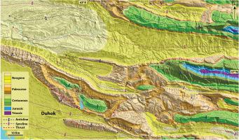
Tectono-stratigraphic evolution, regional structure and fracture patterns of the Zagros fold-thrust belt in the Duhok region, Kurdistan, northern Iraq
Tectonophysics ( IF 2.9 ) Pub Date : 2022-07-25 , DOI: 10.1016/j.tecto.2022.229506 Jamal A.H. Doski , Ken McClay
Tectonophysics ( IF 2.9 ) Pub Date : 2022-07-25 , DOI: 10.1016/j.tecto.2022.229506 Jamal A.H. Doski , Ken McClay
|
This study is the first detailed investigation of the tectono-stratigraphy, regional structure and mesoscopic fractures of the Zagros fold-thrust belt in the Duhok region, Kurdistan, Northern Iraq, and is based on field studies, remote sensing-GIS analyses, cross-section restorations, and tectonic analysis of key structures. The Duhok fold belt is a frontal zone of the north-western part of the Zagros fold and thrust belt in the Kurdistan region near the north-eastern margin of the Arabian Plate. It is characterized by WNW-ESE striking, doubly-plunging, upright symmetric to asymmetric detachment folds that involve ~8.2–10.9 km of Paleozoic to Quaternary strata. These folds vary from 5 to 75 km long, 4–20 km wide and have a surface relief (caused by basement uplift) up to 3.2 km. Five regional and twelve local structural cross-sections were constructed parallel to the regional SSW tectonic transport and perpendicular to the fold axial trends. Section lengths vary between 4.94 km and 101.55 km. Two main detachment levels have been inferred for the Duhok fold belt. A deep basal detachment was placed at the base of the Paleozoic successions within the Ordovician shales of the Khabour Formation at depths from 8 km to 10 km. Shallower, intermediate detachment levels occur within the shales and evaporites of the Mid-Upper Permian and Upper Jurassic strata at depths 1.7 km in the frontal sectors to around 5.5 km in the hinterland. The thickness of the Paleozoic succession in the Duhok fold belt is ~2 km. Deformation by thin-skinned detachment folding together with thick-skinned thrusting is inferred to have occurred in the Duhok region from the Mid Miocene through to the Present-Day. The maximum NNE-SSW-directed shortening produced by detachment folding was about 18.62 km (19.71%) over a section length of 94.45 km. The maximum shortening along thrust faults was around 1.98 km (1.95%) over a section length of 101.55 km. The mesoscopic fracture patterns in the study area were grouped into two major extension sets, four major shear-hybrid sets and eight minor shear-hybrid sets. Field characteristics and relative chronology indicate that most of the fractures are tectonic in origin, and they developed before (i.e., pre-folding fractures) and during (i.e., early- and late-folding fractures) the Mid Miocene folding in the Duhok fold belt.
中文翻译:

伊拉克北部库尔德斯坦杜霍克地区扎格罗斯褶皱逆冲带的构造地层演化、区域结构和断裂模式
这项研究是对伊拉克北部库尔德斯坦杜霍克地区扎格罗斯褶皱逆冲带的构造地层、区域结构和细观裂缝的首次详细调查,以实地研究、遥感GIS分析、交叉研究为基础。剖面修复和关键构造的构造分析。杜霍克褶皱带是靠近阿拉伯板块东北缘的库尔德斯坦地区扎格罗斯褶皱冲断带西北部的锋区。其特点是 WNW-ESE 显着的、双倾倒的、直立的对称至不对称的分离褶皱,涉及约 8.2-10.9 公里的古生界至第四纪地层。这些褶皱长 5 至 75 公里,宽 4 至 20 公里,地表起伏(由基底隆起引起)长达 3.2 公里。平行于区域 SSW 构造运动并垂直于褶皱轴走向构建了 5 个区域和 12 个局部构造截面。路段长度在 4.94 公里至 101.55 公里之间。已推断出 Duhok 褶皱带有两个主要的拆离层。在 Khabour 组奥陶系页岩内的古生代层系底部,存在一个深层基底分离层,深度为 8 公里至 10 公里。较浅的中级滑脱层出现在中上二叠统和上侏罗统地层的页岩和蒸发岩内,深度为锋区 1.7 公里至腹地约 5.5 公里。 Duhok褶皱带古生代层序的厚度约为2公里。据推测,从中中新世中期到现代,Duhok 地区发生了薄皮脱离折叠与厚皮逆冲共同作用的变形。在 94.45 km 的路段长度上,由滑脱折叠产生的最大 NNE-SSW 方向缩短约为 18.62 km(19.71%)。沿逆冲断层的最大缩短约为 1.98 公里(1.95%),截面长度为 101.55 公里。研究区的细观断裂模式分为两个主要延伸组、四个主要剪切混合组和八个次要剪切混合组。现场特征和相对年代学表明,大多数裂缝起源于构造,它们发育在Duhok褶皱带中中新世褶皱之前(即前褶皱裂缝)和期间(即早和晚褶皱裂缝) 。
更新日期:2022-07-25
中文翻译:
伊拉克北部库尔德斯坦杜霍克地区扎格罗斯褶皱逆冲带的构造地层演化、区域结构和断裂模式
这项研究是对伊拉克北部库尔德斯坦杜霍克地区扎格罗斯褶皱逆冲带的构造地层、区域结构和细观裂缝的首次详细调查,以实地研究、遥感GIS分析、交叉研究为基础。剖面修复和关键构造的构造分析。杜霍克褶皱带是靠近阿拉伯板块东北缘的库尔德斯坦地区扎格罗斯褶皱冲断带西北部的锋区。其特点是 WNW-ESE 显着的、双倾倒的、直立的对称至不对称的分离褶皱,涉及约 8.2-10.9 公里的古生界至第四纪地层。这些褶皱长 5 至 75 公里,宽 4 至 20 公里,地表起伏(由基底隆起引起)长达 3.2 公里。平行于区域 SSW 构造运动并垂直于褶皱轴走向构建了 5 个区域和 12 个局部构造截面。路段长度在 4.94 公里至 101.55 公里之间。已推断出 Duhok 褶皱带有两个主要的拆离层。在 Khabour 组奥陶系页岩内的古生代层系底部,存在一个深层基底分离层,深度为 8 公里至 10 公里。较浅的中级滑脱层出现在中上二叠统和上侏罗统地层的页岩和蒸发岩内,深度为锋区 1.7 公里至腹地约 5.5 公里。 Duhok褶皱带古生代层序的厚度约为2公里。据推测,从中中新世中期到现代,Duhok 地区发生了薄皮脱离折叠与厚皮逆冲共同作用的变形。在 94.45 km 的路段长度上,由滑脱折叠产生的最大 NNE-SSW 方向缩短约为 18.62 km(19.71%)。沿逆冲断层的最大缩短约为 1.98 公里(1.95%),截面长度为 101.55 公里。研究区的细观断裂模式分为两个主要延伸组、四个主要剪切混合组和八个次要剪切混合组。现场特征和相对年代学表明,大多数裂缝起源于构造,它们发育在Duhok褶皱带中中新世褶皱之前(即前褶皱裂缝)和期间(即早和晚褶皱裂缝) 。


 京公网安备 11010802027423号