当前位置:
X-MOL 学术
›
Basin Res.
›
论文详情
Our official English website, www.x-mol.net, welcomes your feedback! (Note: you will need to create a separate account there.)
Challenging assumptions of sediment routing in retroarc foreland basins: Detrital zircon evidence for axial versus transverse drainages in the Late Cretaceous of southern Utah, USA
Basin Research ( IF 3.2 ) Pub Date : 2022-07-11 , DOI: 10.1111/bre.12692 Gabriela A. Enriquez St. Pierre 1 , Cari L. Johnson 1
Basin Research ( IF 3.2 ) Pub Date : 2022-07-11 , DOI: 10.1111/bre.12692 Gabriela A. Enriquez St. Pierre 1 , Cari L. Johnson 1
Affiliation
|
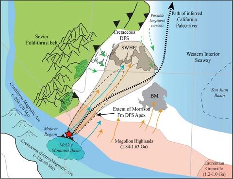
Depositional models for retroarc foreland basin systems commonly imply a direct link between thrust belt dynamics and sediment supply, despite documented complexity between orogen-transverse and orogen-parallel (axial) sediment routing systems. Previous detrital zircon provenance studies from the Straight Cliffs Formation in the Kaiparowits Plateau of southern Utah indicate primary axial source areas to the south (Mogollon Highlands), and southwest (Cordilleran magmatic arc), with relatively minor transverse input from the Sevier fold-thrust belt to the west. Complementary data from 32 new samples are presented to investigate whether these trends persist in correlated strata from sections most proximal to the active fold-thrust belt, as well as strata proximal to the Mogollon Highlands. This study aims to improve statistical robustness through higher-n datasets (>300 analyses/sample) and addresses the possibility of recycling of zircon grains from strata in the exhumed Sevier fold-thrust belt. Based on this provenance dataset, we infer that orogen-transverse deposition was mainly limited to the most proximal sections (within ca. 75 km of the fold-thrust belt), but included episodic distribution across the foredeep that was associated with distinct intervals of widespread amalgamated sand and gravel sheet deposits. In contrast, more distal parts of the foredeep record long-distance fluvial transport (>400 km) of zircons from the active Cordilleran magmatic arc as well as Yavapai-Mazatzal basement rocks in central Arizona (the Mogollon Highlands). Palaeogeographic reconstructions suggest the apex of a large basin-axial fluvial system may have been located at the structural syntaxis between the Sevier fold-thrust belt and western margin of the Mogollon Highlands. This interpretation is supported by detrital zircon data presented here, thus extending the possibility that the Palaeogene ‘California River’ may have existed by at least Late Cretaceous time. Ultimately, these data point to extrabasinal controls on sediment supply, which was largely decoupled from flexural accommodation controls in this archetype retroarc foreland basin.
中文翻译:

具有挑战性的弧后前陆盆地沉积物路径假设:美国犹他州南部晚白垩世轴向和横向排水系统的碎屑锆石证据
弧后前陆盆地系统的沉积模型通常暗示冲断带动力学与沉积物供应之间存在直接联系,尽管造山带-横向和造山带-平行(轴向)沉积物路径系统之间存在复杂性。先前对犹他州南部 Kaiparowits 高原直崖组的碎屑锆石物源研究表明,主要轴向源区位于南部(Mogollon 高地)和西南部(Cordilleran 岩浆弧),来自 Sevier 褶皱冲断带的横向输入相对较小向西。提供了来自 32 个新样本的补充数据,以研究这些趋势是否持续存在于最靠近活动褶皱冲断带的地层的相关地层中,以及靠近 Mogollon 高地的地层中。本研究旨在通过更高 n 的数据集(>300 次分析/样本)提高统计稳健性,并探讨从挖掘出的塞维尔褶皱逆冲带地层中回收锆石颗粒的可能性。基于这个物源数据集,我们推断造山带横向沉积主要限于最近端部分(在褶皱冲断带约 75 公里以内),但包括跨前渊的偶发分布,这与广泛分布的不同间隔有关混合砂和砾石片状沉积物。相比之下,前渊的更远部分记录了来自活跃的科迪勒拉岩浆弧以及亚利桑那州中部(Mogollon 高地)的 Yavapai-Mazatzal 基岩的锆石长距离河流运输(> 400 公里)。古地理重建表明,一个大型盆地-轴向河流系统的顶点可能位于 Sevier 褶皱冲断带和 Mogollon 高地西缘之间的构造构造处。这种解释得到这里提供的碎屑锆石数据的支持,从而扩大了古近纪“加利福尼亚河”至少在晚白垩世时期可能已经存在的可能性。最终,这些数据指向沉积物供应的盆外控制,这在很大程度上与弧后前陆盆地原型中的弯曲调节控制脱钩。从而扩大了古近纪“加利福尼亚河”至少在白垩纪晚期可能已经存在的可能性。最终,这些数据指向沉积物供应的盆外控制,这在很大程度上与弧后前陆盆地原型中的弯曲调节控制脱钩。从而扩大了古近纪“加利福尼亚河”至少在白垩纪晚期可能已经存在的可能性。最终,这些数据指向沉积物供应的盆外控制,这在很大程度上与弧后前陆盆地原型中的弯曲调节控制脱钩。
更新日期:2022-07-11
中文翻译:
具有挑战性的弧后前陆盆地沉积物路径假设:美国犹他州南部晚白垩世轴向和横向排水系统的碎屑锆石证据
弧后前陆盆地系统的沉积模型通常暗示冲断带动力学与沉积物供应之间存在直接联系,尽管造山带-横向和造山带-平行(轴向)沉积物路径系统之间存在复杂性。先前对犹他州南部 Kaiparowits 高原直崖组的碎屑锆石物源研究表明,主要轴向源区位于南部(Mogollon 高地)和西南部(Cordilleran 岩浆弧),来自 Sevier 褶皱冲断带的横向输入相对较小向西。提供了来自 32 个新样本的补充数据,以研究这些趋势是否持续存在于最靠近活动褶皱冲断带的地层的相关地层中,以及靠近 Mogollon 高地的地层中。本研究旨在通过更高 n 的数据集(>300 次分析/样本)提高统计稳健性,并探讨从挖掘出的塞维尔褶皱逆冲带地层中回收锆石颗粒的可能性。基于这个物源数据集,我们推断造山带横向沉积主要限于最近端部分(在褶皱冲断带约 75 公里以内),但包括跨前渊的偶发分布,这与广泛分布的不同间隔有关混合砂和砾石片状沉积物。相比之下,前渊的更远部分记录了来自活跃的科迪勒拉岩浆弧以及亚利桑那州中部(Mogollon 高地)的 Yavapai-Mazatzal 基岩的锆石长距离河流运输(> 400 公里)。古地理重建表明,一个大型盆地-轴向河流系统的顶点可能位于 Sevier 褶皱冲断带和 Mogollon 高地西缘之间的构造构造处。这种解释得到这里提供的碎屑锆石数据的支持,从而扩大了古近纪“加利福尼亚河”至少在晚白垩世时期可能已经存在的可能性。最终,这些数据指向沉积物供应的盆外控制,这在很大程度上与弧后前陆盆地原型中的弯曲调节控制脱钩。从而扩大了古近纪“加利福尼亚河”至少在白垩纪晚期可能已经存在的可能性。最终,这些数据指向沉积物供应的盆外控制,这在很大程度上与弧后前陆盆地原型中的弯曲调节控制脱钩。从而扩大了古近纪“加利福尼亚河”至少在白垩纪晚期可能已经存在的可能性。最终,这些数据指向沉积物供应的盆外控制,这在很大程度上与弧后前陆盆地原型中的弯曲调节控制脱钩。


 京公网安备 11010802027423号