Hydrogeology Journal ( IF 2.8 ) Pub Date : 2022-06-27 , DOI: 10.1007/s10040-022-02503-7 Sahebrao Sonkamble , Subash Chandra , Paras R. Pujari
|
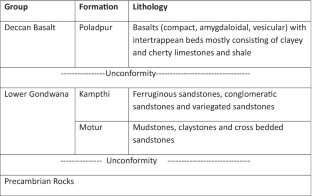
Groundwater occurrence in continental flood basalt, where multiple lava flows separated by intertrappean and irregular patterns of lineaments govern the regional hydro-dynamics, is poorly understood. This necessitates a high-resolution hydrogeophysical investigation to devise an effective groundwater management plan. To enhance the knowledge and unravel the hydrogeological complexity of such systems, an integrated hydrogeophysical investigation consisting of local-scale vertical electrical soundings, ground-based transient electromagnetic soundings, relatively large-scale electrical resistivity tomography (ERT) and helicopter-borne transient electromagnetic (H-TEM) surveys was carried out in an area of the Deccan Traps (372 km2) near Nagpur, central India. A 14.4-km-long and almost continuous profile of ERT was conducted, with special attention to the lateral discontinuity, which was compared with the H-TEM data. The results from these studies were further supported and validated by drilling of exploratory wells at select locations, geophysical logging and pumping tests. Integration of the results successfully provided a geophysical characterization of the basalts, to develop a consistent lithological model that was finally transformed into hydrogeological sections. The pumping test (exploratory wells) derived aquifer transmissivity data that complemented the anomalies of the electrical parameters. Furthermore, the hydrogeological observations revealed that the groundwater yield is strongly correlated (R2 = 0.78) with the depth to the Basalt-Gondwana contact.
中文翻译:
应用机载和地面地球物理学揭示印度中部德干玄武岩的水文地质复杂性
大陆洪水玄武岩中的地下水分布情况知之甚少,其中多个熔岩流由跨层和不规则的线条模式分隔开来控制区域水动力学。这就需要进行高分辨率的水文地球物理调查,以制定有效的地下水管理计划。为了增强知识并揭示此类系统的水文地质复杂性,综合水文地球物理调查包括局部尺度垂直电测深、地面瞬态电磁测深、相对大尺度电阻率层析成像 (ERT) 和直升机载瞬态电磁探测。 H-TEM) 调查是在德干陷阱 (372 km 2) 在印度中部那格浦尔附近。进行了 14.4 公里长且几乎连续的 ERT 剖面,特别注意了横向不连续性,并将其与 H-TEM 数据进行了比较。这些研究的结果通过在选定位置钻探探井、地球物理测井和抽水测试得到进一步支持和验证。结果的整合成功地提供了玄武岩的地球物理特征,以开发一致的岩性模型,最终转化为水文地质剖面。抽水试验(探井)得出的含水层透射率数据补充了电气参数的异常。此外,水文地质观测表明,地下水产量有很强的相关性(R 2= 0.78)与玄武岩-冈瓦纳接触的深度。


 京公网安备 11010802027423号