Journal of Geodesy ( IF 4.4 ) Pub Date : 2022-06-23 , DOI: 10.1007/s00190-022-01631-y L. E. Sjöberg , M. Abrehdary
|
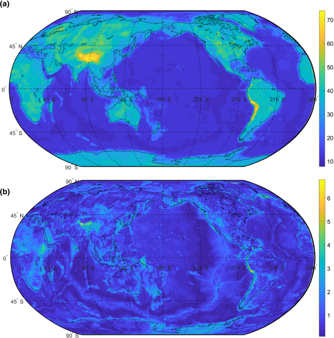
The purpose of this study is to determine MOHV21, a Moho depth model based on an optimal combination of five global seismic and gravimetric-isostatic models of Moho depth by a weighted least squares approach at a resolution of 1° × 1°. For proper weighting among the data, the study starts with determining (mostly missing) standard errors and correlations among the models. The standard errors among the input models range from 1.0 (in Brazil) to 6.8 km (in Peru) and from 0.1 (in Huna Bay) to 6.0 km (in East Pacific Ridge) for Moho depth on land and ocean, respectively. The correlations among the five models range between − 0.99 and + 0.90. The Moho depths for MOHV21 at land regions vary between 14.5 (at the Horn of Africa) and 75 km (in the Himalayas) and between 6.6 (in the Greenland Sea) and 51.8 (in the Gulf of Bothnia) for land and ocean regions, respectively (However, note that, the Gulf of Bothnia belongs to continental crust, while the oceanic crust is generally within 20 km). The standard errors are generally within a few km but reaches 6.8 km (9%) in the highest mountains. The shallow Moho depths along mid-ocean ridges are well exposed in the model. Notable regional Moho highs are visualized in the Tarim basin in NW China of 59 ± 6.5 km and in Central Finland of 57 ± 4.7 km. A comparison of MOHV21 with a mosaic of regional models shows large differences reaching ± 25 km in Africa, Antarctic, and parts of S. America, while the differences are relatively modest in those parts of oceans that are available in the regional models.


 京公网安备 11010802027423号