Precision Agriculture ( IF 6.2 ) Pub Date : 2022-06-21 , DOI: 10.1007/s11119-022-09908-0 Juliette Maire , Simon Gibson-Poole , Nicholas Cowan , Dominika Krol , Cathal Somers , Dave S. Reay , Ute Skiba , Robert M. Rees , Gary J. Lanigan , Karl G. Richards
|
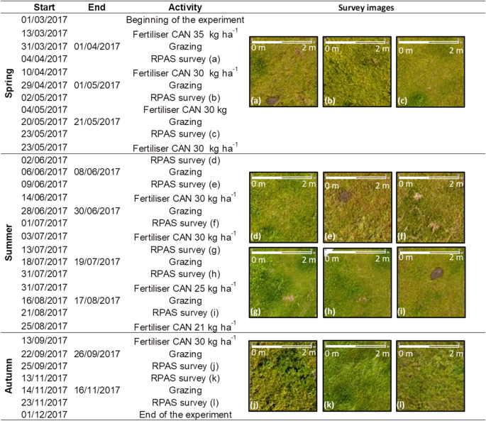
Most nitrogen (N) lost to the environment from grazed grassland is produced as a result of N excreted by livestock, released in the form of nitrous oxide (N2O) emissions, nitrate leaching and ammonia volatilisation. In addition to the N fertiliser applied, excreta deposited by grazing livestock constitute a heterogeneous excess of N, creating spatial hotspots of N losses. This study presents a yearlong N2O emissions map from a typical intensively managed temperate grassland, grazed periodically by a dairy herd. The excreta deposition mapping was undertaken using high-resolution RGB images captured with a remotely piloted aircraft system combined with N2O emissions measurements using closed statics chambers. The annual N2O emissions were estimated to be 3.36 ± 0.30 kg N2O–N ha−1 after a total N applied from fertiliser and excreta of 608 ± 40 kg N ha−1 yr−1. Emissions of N2O were 1.9, 3.6 and 4.4 times lower than that estimated using the default IPCC 2019, 2006 or country-specific emission factors, respectively. The spatial distribution and size of excreta deposits was non-uniform, and in each grazing period, an average of 15.1% of the field was covered by urine patches and 1.0% by dung deposits. Some areas of the field repeatedly received urine deposits, accounting for an estimated total of 2410 kg N ha−1. The method reported in this study can provide better estimates of how management practices can mitigate N2O emissions, to develop more efficient selective approaches to fertiliser application, targeted nitrification inhibitor application and improvements in the current N2O inventory estimation.
中文翻译:
航拍图像中的氮输入映射能否改善放牧草地的一氧化二氮排放估算?
放牧草地向环境损失的大部分氮 (N) 是由牲畜排泄的氮产生的,以一氧化二氮 (N 2 O) 排放、硝酸盐浸出和氨挥发的形式释放。除了施氮肥外,放牧牲畜的排泄物构成了不均匀的氮过剩,造成了氮损失的空间热点。本研究展示了一个典型的集约化管理温带草原一年的 N 2 O 排放图,奶牛群定期放牧。使用遥控飞机系统捕获的高分辨率 RGB 图像结合使用封闭静力室的 N 2 O 排放测量进行排泄物沉积测绘。年度 N 2在从肥料和排泄物中施用的总氮量为 608 ± 40 kg N ha -1 yr -1之后,O 排放量估计为 3.36 ± 0.30 kg N 2 O–N ha -1。N 2 O 的排放量分别比使用默认 IPCC 2019、2006 或国家特定排放因子估计的低 1.9、3.6 和 4.4 倍。粪便沉积物的空间分布和大小不均匀,在每个放牧时期,平均有15.1%的田地被尿斑覆盖,1.0%的土地被粪便沉积物覆盖。该田地的一些区域反复出现尿液沉积物,估计总数为 2410 kg N ha -1. 本研究报告的方法可以更好地估计管理实践如何减少 N 2 O 排放,从而开发更有效的施肥选择性方法、有针对性的硝化抑制剂应用以及改进当前的 N 2 O 库存估算。


 京公网安备 11010802027423号