Landscape and Urban Planning ( IF 9.1 ) Pub Date : 2022-06-20 , DOI: 10.1016/j.landurbplan.2022.104500 Karen T. Lourdes , Perrine Hamel , Chris N. Gibbins , Ruzana Sanusi , Badrul Azhar , Alex M. Lechner
|
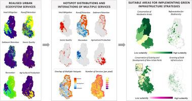
Unprecedented urban growth and extensive land use change especially in the Global South has placed increasing pressure on urban ecosystem services (UES). While there are numerous studies modelling and mapping ecosystem services, integrating the outputs of multiple ecosystem service assessments to provide recommendations for nature-based planning remains a challenge. The objective of this study is to characterise the spatial distribution of multiple UES in a rapidly urbanising catchment and to develop a systematic approach to facilitate the integration of UES into planning green infrastructure (GI). We used InVEST models to spatially quantify and map six realised UES (heat mitigation, runoff retention, sediment retention, scenic quality, urban recreation and agricultural production (i.e., ‘urban farming’)) in a rapidly developing, peri-urban catchment in Greater Kuala Lumpur, Malaysia. We identified synergies and tradeoffs between services and assessed the cooccurrence and overlap of hotspots between multiples services. Our assessment revealed that densely built areas generally had low UES provision. In the final step, we conducted a multicriteria analysis using ecosystem services-based criteria to identify locations for five GI strategies: conservation of headwaters, reforestation for biodiversity, development and conservation of urban parks and greening of built infrastructure (e.g., green walls and roofs). The selection of the appropriate GI strategy must consider the degree of urban development, especially in areas where multiple strategies were suitable. The findings of our study support GI planning within the catchment and the methods applied can be adapted to support sustainable land use management in urban areas globally.
中文翻译:
使用多种城市生态系统服务模型和多标准分析规划绿色基础设施
前所未有的城市增长和广泛的土地利用变化,尤其是在全球南方,对城市生态系统服务 (UES) 造成了越来越大的压力。虽然有许多研究对生态系统服务进行建模和绘图,但整合多个生态系统服务评估的结果以提供基于自然的规划建议仍然是一个挑战。本研究的目的是描述快速城市化流域中多个 UES 的空间分布特征,并开发一种系统方法来促进 UES 与规划绿色基础设施 (GI) 的整合。我们使用 InVEST 模型对快速发展的六个已实现的 UES(热缓解、径流滞留、沉积物滞留、风景质量、城市休闲和农业生产(即“城市农业”))进行空间量化和映射,马来西亚大吉隆坡的郊区集水区。我们确定了服务之间的协同作用和权衡,并评估了多个服务之间热点的共现和重叠。我们的评估显示,密集建筑区域的 UES 供给普遍较低。在最后一步,我们使用基于生态系统服务的标准进行了多标准分析,以确定五种地理标志战略的位置:保护源头、重新造林以促进生物多样性、城市公园的开发和保护以及建筑基础设施的绿化(例如,绿化墙壁和屋顶)。选择合适的地理标志战略必须考虑城市发展程度,特别是在适合多种战略的地区。


 京公网安备 11010802027423号