Journal of Archaeological Method and Theory ( IF 3.073 ) Pub Date : 2022-06-18 , DOI: 10.1007/s10816-022-09567-5 D. Gal , H. Saaroni , D. Cvikel
|
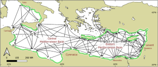
A comprehensive mapping of potential sailing mobility was performed for the eastern and central Mediterranean basins. The mapping is based on newly developed methods for measuring potential sailing mobility of merchant ships with a loose-footed square sail in antiquity, both for direct passages and for coastal sailing. The metrics of the measured direct and coastal sailing passages generate new measures of potential sailing mobility that provide new insights into the functioning of maritime links. The study also applies the measurements to several case studies in historical context including mapping of potential sailing mobility for the grain shipments from Egypt to Rome and the potential sailing mobility of Phoenician maritime links between the Levant and colonies to the west. The mappings reveal the bottlenecks for westward sailing from the Levant in the summer months. The mappings also highlight the bi-directional sailing links that could be maintained throughout the summer season despite the prevailing Etesian winds. The mappings contribute to deeper understanding of seafaring options and challenges during Antiquity.
中文翻译:
古代地中海潜在航行流动性的测绘
对地中海东部和中部盆地的潜在航行流动性进行了综合测绘。该映射基于新开发的方法,用于测量古代带有松脚方帆的商船的潜在航行机动性,无论是直接通过还是沿海航行。测量的直接和沿海航行通道的指标产生了潜在航行流动性的新措施,为海上联系的运作提供了新的见解。该研究还将测量结果应用于历史背景下的几个案例研究,包括绘制从埃及到罗马的谷物运输的潜在航行流动性以及黎凡特和西部殖民地之间腓尼基海上联系的潜在航行流动性。这些地图揭示了夏季从黎凡特向西航行的瓶颈。这些地图还突出了双向航行链接,尽管盛行 Etesian 风,但可以在整个夏季保持。这些映射有助于更深入地了解古代航海选择和挑战。


 京公网安备 11010802027423号