当前位置:
X-MOL 学术
›
Remote Sens. Ecol. Conserv.
›
论文详情
Our official English website, www.x-mol.net, welcomes your feedback! (Note: you will need to create a separate account there.)
Landsat time series reveal forest loss and woody encroachment in the Ngorongoro Conservation Area, Tanzania
Remote Sensing in Ecology and Conservation ( IF 5.5 ) Pub Date : 2022-06-15 , DOI: 10.1002/rse2.277 Joana Borges 1 , Thomas P. Higginbottom 2 , Bradley Cain 1 , Donatus E. Gadiye 3 , Alex Kisingo 4 , Martin Jones 1 , Elias Symeonakis 1
Remote Sensing in Ecology and Conservation ( IF 5.5 ) Pub Date : 2022-06-15 , DOI: 10.1002/rse2.277 Joana Borges 1 , Thomas P. Higginbottom 2 , Bradley Cain 1 , Donatus E. Gadiye 3 , Alex Kisingo 4 , Martin Jones 1 , Elias Symeonakis 1
Affiliation
|
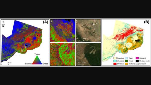
The Ngorongoro Conservation Area (NCA) of Tanzania, is globally significant for biodiversity conservation due to the presence of iconic fauna, and, since 1959 has been managed as a unique multiple land-use areas to mutually benefit wildlife and indigenous residents. Understating vegetation dynamics and ongoing land cover change processes in protected areas is important to protect biodiversity and ensure sustainable development. However, land cover changes in savannahs are especially difficult, as changes are often long-term and subtle. Here, we demonstrate a Landsat-based monitoring strategy incorporating (i) regression-based unmixing for the accurate mapping of the fraction of the different land cover types, and (ii) a combination of linear regression and the BFAST trend break analysis technique for mapping and quantifying land cover changes. Using Google Earth Pro and the EnMap-Box software, the fractional cover of the main land cover types of the NCA were accurately mapped for the first time, namely bareland, bushland, cropland, forest, grassland, montane heath, shrubland, water and woodland. Our results show that the main changes occurring in the NCA are the degradation of upland forests into bushland: we exemplify this with a case study in the Lerai Forest; and found declines in grassland and co-incident increases in shrubland in the Serengeti Plains, suggesting woody encroachment. These changes threaten the wellbeing of livestock, the livelihoods of resident pastoralists and of the wildlife dependent on these grazing areas. Some of the land cover changes may be occurring naturally and caused by herbivory, rainfall patterns and vegetation succession, but many are linked to human activity, specifically, management policies, tourism development and the increase in human population and livestock. Our study provides for the first time much needed and highly accurate information on long-term land cover changes in the NCA that can support the sustainable management and conservation of this unique UNESCO World Heritage Site.
中文翻译:

Landsat 时间序列揭示了坦桑尼亚恩戈罗恩戈罗保护区的森林流失和木质侵蚀
坦桑尼亚的恩戈罗恩戈罗保护区 (NCA) 由于标志性动物群的存在而在全球范围内对生物多样性保护具有重要意义,并且自 1959 年以来一直作为独特的多重土地利用区进行管理,以使野生动物和土著居民互惠互利。了解保护区内的植被动态和正在进行的土地覆盖变化过程对于保护生物多样性和确保可持续发展非常重要。然而,大草原上的土地覆盖变化尤其困难,因为变化通常是长期且微妙的。在这里,我们展示了一种基于 Landsat 的监测策略,其中包括 (i) 基于回归的分离,用于准确映射不同土地覆盖类型的比例,以及 (ii) 线性回归和 BFAST 趋势突破分析技术的组合用于映射量化土地覆盖变化。利用Google Earth Pro和EnMap-Box软件,首次准确绘制了NCA主要土地覆盖类型的覆盖率,即裸地、灌木丛、农田、森林、草地、山地荒地、灌丛、水域和林地. 我们的结果表明,NCA 发生的主要变化是高地森林退化为灌木丛:我们以勒莱森林的案例研究为例;并发现塞伦盖蒂平原的草地减少和灌木丛的同时增加,表明木本植物的侵蚀。这些变化威胁到牲畜的福祉、当地牧民的生计以及依赖这些放牧区的野生动物。一些土地覆盖变化可能是自然发生的,是由食草动物、降雨模式和植被演替引起的,但许多与人类活动有关,特别是管理政策、旅游业发展以及人口和牲畜的增加。我们的研究首次提供了关于 NCA 长期土地覆盖变化的急需且高度准确的信息,这些信息可以支持这一独特的联合国教科文组织世界遗产地的可持续管理和保护。
更新日期:2022-06-15
中文翻译:
Landsat 时间序列揭示了坦桑尼亚恩戈罗恩戈罗保护区的森林流失和木质侵蚀
坦桑尼亚的恩戈罗恩戈罗保护区 (NCA) 由于标志性动物群的存在而在全球范围内对生物多样性保护具有重要意义,并且自 1959 年以来一直作为独特的多重土地利用区进行管理,以使野生动物和土著居民互惠互利。了解保护区内的植被动态和正在进行的土地覆盖变化过程对于保护生物多样性和确保可持续发展非常重要。然而,大草原上的土地覆盖变化尤其困难,因为变化通常是长期且微妙的。在这里,我们展示了一种基于 Landsat 的监测策略,其中包括 (i) 基于回归的分离,用于准确映射不同土地覆盖类型的比例,以及 (ii) 线性回归和 BFAST 趋势突破分析技术的组合用于映射量化土地覆盖变化。利用Google Earth Pro和EnMap-Box软件,首次准确绘制了NCA主要土地覆盖类型的覆盖率,即裸地、灌木丛、农田、森林、草地、山地荒地、灌丛、水域和林地. 我们的结果表明,NCA 发生的主要变化是高地森林退化为灌木丛:我们以勒莱森林的案例研究为例;并发现塞伦盖蒂平原的草地减少和灌木丛的同时增加,表明木本植物的侵蚀。这些变化威胁到牲畜的福祉、当地牧民的生计以及依赖这些放牧区的野生动物。一些土地覆盖变化可能是自然发生的,是由食草动物、降雨模式和植被演替引起的,但许多与人类活动有关,特别是管理政策、旅游业发展以及人口和牲畜的增加。我们的研究首次提供了关于 NCA 长期土地覆盖变化的急需且高度准确的信息,这些信息可以支持这一独特的联合国教科文组织世界遗产地的可持续管理和保护。


 京公网安备 11010802027423号