International Journal of Coal Science & Technology Pub Date : 2022-06-04 , DOI: 10.1007/s40789-022-00513-0 Wu Xiao , He Ren , Tao Sui , Heyu Zhang , Yanling Zhao , Zhenqi Hu
|
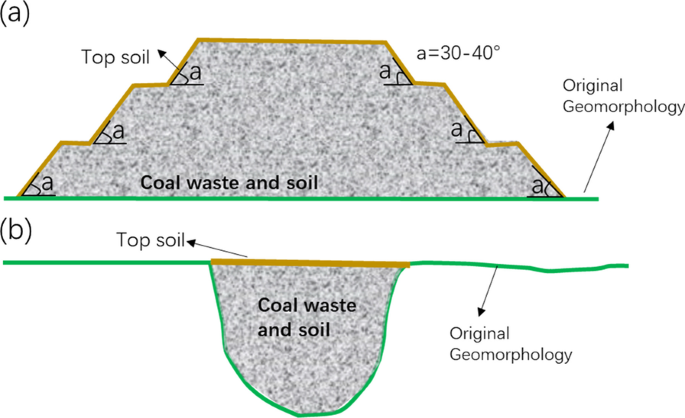
Opencast coal mining has a large impact on the land surface, both at the mining pits themselves and at waste sites. After artificial management is stopped, a reclaimed opencast coal mine dump is affected by wind and water erosion from natural processes, resulting in land degradation and even safety incidents. In this paper, the soil erosion and land degradation after 5 years of such natural processes, at the Xilinhot opencast coal mine dump in Inner Mongolia, were investigated. A multi-source data acquisition method was applied: the vegetation fraction coverage (VFC) was extracted from GF-1 satellite imagery, high-precision terrain characteristics and the location and degree of soil erosion were obtained using a drone, and the physical properties of the topsoil were obtained by field sampling. On this basis, the degree and spatial distribution of erosion cracks were identified, and the causes of soil erosion and land degradation were analyzed using the geographical detector. The results show that (1) multi-source data acquisition method can provide effective basic data for the quantitative evaluation of the ecological environment at dumps, and (2) slope aspect and VFC are the main factors affecting the degree of degradation and soil erosion. Based on above analysis, several countermeasures are proposed to mitigate land degradation: (1) The windward slope be designed to imitate the natural landform. (2) Reasonable engineering measures should be applied at the slope to restrain soil erosion. (3) The Pioneer plants should be widely planted on the platform at the early stage of reclamation.
中文翻译:
自然过程演变 5 年后露天煤矿垃圾场土地退化和土壤侵蚀的无人机和实地调查
露天煤矿开采对地表有很大的影响,无论是在矿坑本身还是在废料场。停止人工管理后,复垦的露天煤矿堆场受到自然过程的风蚀和水蚀的影响,导致土地退化甚至安全事故。本文研究了内蒙古锡林浩特露天煤矿垃圾场经过 5 年自然过程后的土壤侵蚀和土地退化。采用多源数据采集方法:从高分一号卫星影像中提取植被分数覆盖率(VFC),利用无人机获取高精度地形特征和水土流失的位置和程度,并利用无人机获取水土流失的物理性质。表土是通过现场采样获得的。以这个为基础,识别侵蚀裂缝的程度和空间分布,利用地理探测器分析水土流失和土地退化的原因。结果表明:(1)多源数据采集方法可为垃圾场生态环境定量评价提供有效的基础数据,(2)坡向和VFC是影响退化程度和水土流失程度的主要因素。基于以上分析,提出了减缓土地退化的若干对策: (1) 设计迎风坡以模仿自然地貌。(2)边坡应采取合理的工程措施,抑制水土流失。(3) 开垦初期应在平台上广泛种植先锋植物。并利用地理探测器分析水土流失和土地退化的原因。结果表明:(1)多源数据采集方法可为垃圾场生态环境定量评价提供有效的基础数据,(2)坡向和VFC是影响退化程度和水土流失程度的主要因素。基于以上分析,提出了减缓土地退化的若干对策: (1) 设计迎风坡以模仿自然地貌。(2)边坡应采取合理的工程措施,抑制水土流失。(3) 开垦初期应在平台上广泛种植先锋植物。并利用地理探测器分析水土流失和土地退化的原因。结果表明:(1)多源数据采集方法可为垃圾场生态环境定量评价提供有效的基础数据,(2)坡向和VFC是影响退化程度和水土流失程度的主要因素。基于以上分析,提出了减缓土地退化的若干对策: (1) 设计迎风坡以模仿自然地貌。(2)边坡应采取合理的工程措施,抑制水土流失。(3) 开垦初期应在平台上广泛种植先锋植物。结果表明:(1)多源数据采集方法可为垃圾场生态环境定量评价提供有效的基础数据,(2)坡向和VFC是影响退化程度和水土流失程度的主要因素。基于以上分析,提出了减缓土地退化的若干对策: (1) 设计迎风坡以模仿自然地貌。(2)边坡应采取合理的工程措施,抑制水土流失。(3) 开垦初期应在平台上广泛种植先锋植物。结果表明:(1)多源数据采集方法可为垃圾场生态环境定量评价提供有效的基础数据,(2)坡向和VFC是影响退化程度和水土流失程度的主要因素。基于以上分析,提出了减缓土地退化的若干对策: (1) 设计迎风坡以模仿自然地貌。(2)边坡应采取合理的工程措施,抑制水土流失。(3) 开垦初期应在平台上广泛种植先锋植物。提出了缓解土地退化的若干对策: (1) 迎风坡设计模仿自然地貌。(2)边坡应采取合理的工程措施,抑制水土流失。(3) 开垦初期应在平台上广泛种植先锋植物。提出了缓解土地退化的若干对策: (1) 迎风坡设计模仿自然地貌。(2)边坡应采取合理的工程措施,抑制水土流失。(3) 开垦初期应在平台上广泛种植先锋植物。


 京公网安备 11010802027423号