Hydrogeology Journal ( IF 2.8 ) Pub Date : 2022-04-26 , DOI: 10.1007/s10040-022-02486-5 Daniel Hervé Gouet 1 , Janvier Domra Kana 1 , Valentin Oya 2 , Fontama Yuka Ewembe 3
|
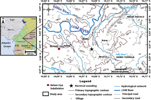
Lom River basin, associated with outflow from the Lom River system, is located in the East Region of Cameroon. The geology of the basin comprises Precambrian crystalline and crystallophyllian rocks, which are characterized by their compact nature and their low capacity to hold water. Permeable horizons observed in these rocks have developed through fracturing and weathering processes. Direct current (DC) geoelectrical surveys have been carried out in the Lom River basin, especially in the Betare Oya subdivision (administrative unit). The main objective of these surveys was to determine the major features of the permeable layers or aquifers of the hydrogeological network of the Lom River basin. Results from the collected data, interpreted with appropriate software and correlated with geological and hydrogeological field data, identified the conductive zones, characterized by vertical and lateral resistivity contrasts. The conductive zones represent the fractured and weathered horizons or permeable horizons, and these are protected from above by a variable overburden. This has enabled delineation of the shallow aquifer of weathered and decayed rocks and the deeper aquifer of the fissured basement. The groundwater flow direction in the deeper aquifer is NE–SW, i.e. parallel to the flow direction of Lom River. The study reveals the effectiveness of the DC electrical method in characterization of the flows of hydrogeological networks of river basins.
中文翻译:
使用直流电法表征喀麦隆东部 Lom 河流域水文地质网络中的地下水
洛姆河流域与洛姆河系统的流出有关,位于喀麦隆东部地区。该盆地的地质包括前寒武纪结晶岩和晶叶岩,其特点是致密性和低保水能力。在这些岩石中观察到的渗透层是通过压裂和风化过程形成的。在 Lom 河流域进行了直流 (DC) 地电勘测,特别是在 Betare Oya 分区(行政单位)。这些调查的主要目的是确定 Lom 河流域水文地质网络的渗透层或含水层的主要特征。收集数据的结果,用适当的软件解释并与地质和水文地质数据相关联,确定了导电区,其特点是垂直和横向电阻率对比。导电层代表破裂和风化的层位或渗透层位,这些层位受到可变覆盖层的保护。这使得能够划定风化和腐烂岩石的浅层含水层和裂隙基底的深层含水层。较深含水层的地下水流向为NE-SW,即平行于Lom 河的流向。该研究揭示了直流电法在表征流域水文地质网络流量方面的有效性。这使得能够划定风化和腐烂岩石的浅层含水层和裂隙基底的深层含水层。较深含水层的地下水流向为NE-SW,即平行于Lom 河的流向。该研究揭示了直流电法在表征流域水文地质网络流量方面的有效性。这使得能够划定风化和腐烂岩石的浅层含水层和裂隙基底的深层含水层。较深含水层的地下水流向为NE-SW,即平行于Lom 河的流向。该研究揭示了直流电法在表征流域水文地质网络流量方面的有效性。


 京公网安备 11010802027423号