当前位置:
X-MOL 学术
›
Remote Sens. Ecol. Conserv.
›
论文详情
Our official English website, www.x-mol.net, welcomes your feedback! (Note: you will need to create a separate account there.)
Mapping terrestrial groundwater-dependent ecosystems in arid Australia using Landsat-8 time-series data and singular value decomposition
Remote Sensing in Ecology and Conservation ( IF 5.5 ) Pub Date : 2022-03-13 , DOI: 10.1002/rse2.254 Jayne Brim Box 1, 2 , Ian Leiper 1 , Catherine Nano 1 , Danielle Stokeld 1 , Peter Jobson 1 , Adrian Tomlinson 2 , Dale Cobban 2 , Tim Bond 2 , Debbie Randall 1 , Paul Box 3
Remote Sensing in Ecology and Conservation ( IF 5.5 ) Pub Date : 2022-03-13 , DOI: 10.1002/rse2.254 Jayne Brim Box 1, 2 , Ian Leiper 1 , Catherine Nano 1 , Danielle Stokeld 1 , Peter Jobson 1 , Adrian Tomlinson 2 , Dale Cobban 2 , Tim Bond 2 , Debbie Randall 1 , Paul Box 3
Affiliation
|
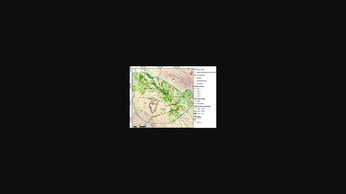
The spatial extent of terrestrial vegetation types reliant on groundwater in arid Australia is poorly known, largely because they are located in remote areas that are expensive to survey. In previous attempts, the use of traditional remote sensing approaches failed to discriminate vegetation using groundwater from surrounding vegetation. Difficulties in discerning vegetation groundwater use by remote sensing may be exacerbated by the unpredictable rainfall patterns and lack of annual wet and dry seasons common in arid Australia. This study presents a novel approach to mapping terrestrial groundwater-dependent ecosystems (GDEs) by applying singular value decomposition (SVD) to time-series of vegetation indices derived from Landsat-8 data, to isolate the temporal and spatial sources of variation associated with groundwater use. In-situ data from 442 sites were used to supervise and validate logistic regression models and neural networks, to determine whether sites could be correctly classified as GDEs using components obtained from the SVD. These results were used to produce a probability map of GDE occurrence across a 557 000 ha study area. Overall accuracy of the final classification map was 79%, with 72% of sites correctly identified as GDEs (true positives) and 16% incorrectly classified as GDEs (false positives). The approach is broadly applicable in arid regions globally, and is easily validated if general background knowledge of regional vegetation exists. Globally, and going forward, increased water extraction is expected to severely limit water available for GDEs. Successfully mapping GDEs in arid environments is a critical step towards their sustainable management, and the human and natural systems reliant upon them.
中文翻译:

使用 Landsat-8 时间序列数据和奇异值分解绘制澳大利亚干旱地区依赖陆地地下水的生态系统
在干旱的澳大利亚,依赖地下水的陆地植被类型的空间范围鲜为人知,主要是因为它们位于偏远地区,勘测成本很高。在以前的尝试中,使用传统的遥感方法未能将使用地下水的植被与周围植被区分开来。在干旱的澳大利亚,不可预测的降雨模式和缺乏年度干湿季节可能会加剧通过遥感辨别植被地下水使用的困难。本研究通过将奇异值分解 (SVD) 应用于从 Landsat-8 数据得出的植被指数时间序列,提出了一种绘制依赖于陆地地下水的生态系统 (GDE) 的新方法,以隔离与地下水相关的时间和空间变化源利用。原位来自 442 个站点的数据用于监督和验证逻辑回归模型和神经网络,以确定站点是否可以使用从 SVD 获得的组件正确分类为 GDE。这些结果被用来制作一个 557 000 公顷研究区域的 GDE 发生概率图。最终分类图的总体准确率为 79%,其中 72% 的站点被正确识别为 GDE(真阳性),16% 被错误地归类为 GDE(假阳性)。该方法广泛适用于全球干旱地区,如果存在区域植被的一般背景知识,则很容易验证。在全球范围内,展望未来,预计增加的取水量将严重限制 GDE 的可用水量。在干旱环境中成功绘制 GDE 地图是实现可持续管理的关键一步,
更新日期:2022-03-13
中文翻译:
使用 Landsat-8 时间序列数据和奇异值分解绘制澳大利亚干旱地区依赖陆地地下水的生态系统
在干旱的澳大利亚,依赖地下水的陆地植被类型的空间范围鲜为人知,主要是因为它们位于偏远地区,勘测成本很高。在以前的尝试中,使用传统的遥感方法未能将使用地下水的植被与周围植被区分开来。在干旱的澳大利亚,不可预测的降雨模式和缺乏年度干湿季节可能会加剧通过遥感辨别植被地下水使用的困难。本研究通过将奇异值分解 (SVD) 应用于从 Landsat-8 数据得出的植被指数时间序列,提出了一种绘制依赖于陆地地下水的生态系统 (GDE) 的新方法,以隔离与地下水相关的时间和空间变化源利用。原位来自 442 个站点的数据用于监督和验证逻辑回归模型和神经网络,以确定站点是否可以使用从 SVD 获得的组件正确分类为 GDE。这些结果被用来制作一个 557 000 公顷研究区域的 GDE 发生概率图。最终分类图的总体准确率为 79%,其中 72% 的站点被正确识别为 GDE(真阳性),16% 被错误地归类为 GDE(假阳性)。该方法广泛适用于全球干旱地区,如果存在区域植被的一般背景知识,则很容易验证。在全球范围内,展望未来,预计增加的取水量将严重限制 GDE 的可用水量。在干旱环境中成功绘制 GDE 地图是实现可持续管理的关键一步,


 京公网安备 11010802027423号