当前位置:
X-MOL 学术
›
Remote Sens. Ecol. Conserv.
›
论文详情
Our official English website, www.x-mol.net, welcomes your feedback! (Note: you will need to create a separate account there.)
How can Sentinel-2 contribute to seagrass mapping in shallow, turbid Baltic Sea waters?
Remote Sensing in Ecology and Conservation ( IF 5.5 ) Pub Date : 2021-12-07 , DOI: 10.1002/rse2.246 Katja Kuhwald 1 , Jens Schneider von Deimling 2 , Philipp Schubert 3 , Natascha Oppelt 1
Remote Sensing in Ecology and Conservation ( IF 5.5 ) Pub Date : 2021-12-07 , DOI: 10.1002/rse2.246 Katja Kuhwald 1 , Jens Schneider von Deimling 2 , Philipp Schubert 3 , Natascha Oppelt 1
Affiliation
|
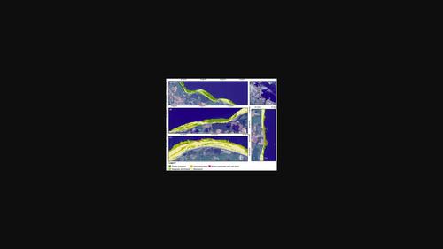
Seagrass meadows are one of the most important benthic habitats in the Baltic Sea. Nevertheless, spatially continuous mapping data of Zostera marina, the predominant seagrass species in the Baltic Sea, are lacking in the shallow coastal waters. Sentinel-2 turned out to be valuable for mapping coastal benthic habitats in clear waters, whereas knowledge in turbid waters is rare. Here, we transfer a clear water mapping approach to turbid waters to assess how Sentinel-2 can contribute to seagrass mapping in the Western Baltic Sea. Sentinel-2 data were atmospherically corrected using ACOLITE and subsequently corrected for water column effects. To generate a data basis for training and validating random forest classification models, we developed an upscaling approach using video transect data and aerial imagery. We were able to map five coastal benthic habitats: bare sand (25 km²), sand dominated (16 km²), seagrass dominated (7 km²), dense seagrass (25 km²) and mixed substrates with red/ brown algae (3.5 km²) in a study area along the northern German coastline. Validation with independent data pointed out that water column correction does not significantly improve classification results compared to solely atmospherically corrected data (balanced overall accuracies ~0.92). Within optically shallow waters (0–4 m), per class and overall balanced accuracies (>0.82) differed marginally depending on the water depth. Overall balanced accuracy became worse (<0.8) approaching the border to optically deep water (~ 5 m). The spatial resolution of Sentinel-2 (10–20 m) allowed delineating detailed spatial patterns of seagrass habitats, which may serve as a basis to retrieve spatially continuous data for ecologically relevant metrics such as patchiness. Thus, Sentinel-2 can contribute unprecedented information for seagrass mapping between 0 and around 5 m water depths in the Western Baltic Sea.
中文翻译:

Sentinel-2 如何在波罗的海浅而浑浊的海域绘制海草图?
海草草甸是波罗的海最重要的底栖生物栖息地之一。然而,Zostera marina的空间连续映射数据波罗的海的主要海草物种,在沿海浅水区缺乏。Sentinel-2 被证明对于在清澈的海水中绘制沿海底栖生物栖息地很有价值,而在浑水中的知识却很少。在这里,我们将清澈的水测绘方法转移到浑浊的水域,以评估 Sentinel-2 如何有助于波罗的海西部的海草测绘。Sentinel-2 数据使用 ACOLITE 进行了大气校正,随后针对水柱效应进行了校正。为了生成用于训练和验证随机森林分类模型的数据基础,我们开发了一种使用视频样带数据和航空影像的升级方法。我们能够绘制五个沿海底栖生物栖息地的地图:裸沙(25 平方公里)、以沙为主(16 平方公里)、以海草为主(7 平方公里)、在德国北部海岸线的一个研究区域中,密集的海草(25 平方公里)和含有红/褐藻的混合基质(3.5 平方公里)。独立数据的验证指出,与仅通过大气校正的数据相比,水柱校正不会显着改善分类结果(平衡的整体准确度约为 0.92)。在光学浅水(0-4 m)内,每类和整体平衡精度(> 0.82)根据水深略有不同。接近光学深水(~ 5 m)的边界时,整体平衡精度变得更差(<0.8)。Sentinel-2(10-20 m)的空间分辨率允许描绘海草栖息地的详细空间模式,这可以作为检索空间连续数据以获取生态相关指标(如斑块)的基础。因此,
更新日期:2021-12-07
中文翻译:
Sentinel-2 如何在波罗的海浅而浑浊的海域绘制海草图?
海草草甸是波罗的海最重要的底栖生物栖息地之一。然而,Zostera marina的空间连续映射数据波罗的海的主要海草物种,在沿海浅水区缺乏。Sentinel-2 被证明对于在清澈的海水中绘制沿海底栖生物栖息地很有价值,而在浑水中的知识却很少。在这里,我们将清澈的水测绘方法转移到浑浊的水域,以评估 Sentinel-2 如何有助于波罗的海西部的海草测绘。Sentinel-2 数据使用 ACOLITE 进行了大气校正,随后针对水柱效应进行了校正。为了生成用于训练和验证随机森林分类模型的数据基础,我们开发了一种使用视频样带数据和航空影像的升级方法。我们能够绘制五个沿海底栖生物栖息地的地图:裸沙(25 平方公里)、以沙为主(16 平方公里)、以海草为主(7 平方公里)、在德国北部海岸线的一个研究区域中,密集的海草(25 平方公里)和含有红/褐藻的混合基质(3.5 平方公里)。独立数据的验证指出,与仅通过大气校正的数据相比,水柱校正不会显着改善分类结果(平衡的整体准确度约为 0.92)。在光学浅水(0-4 m)内,每类和整体平衡精度(> 0.82)根据水深略有不同。接近光学深水(~ 5 m)的边界时,整体平衡精度变得更差(<0.8)。Sentinel-2(10-20 m)的空间分辨率允许描绘海草栖息地的详细空间模式,这可以作为检索空间连续数据以获取生态相关指标(如斑块)的基础。因此,


 京公网安备 11010802027423号