Safety Science ( IF 6.1 ) Pub Date : 2021-12-03 , DOI: 10.1016/j.ssci.2021.105616 Marcos Rodrigues 1, 2 , María Zúñiga-Antón 2, 3 , Fermín Alcasena 4 , Pere Gelabert 1 , Cristina Vega-Garcia 1, 5
|
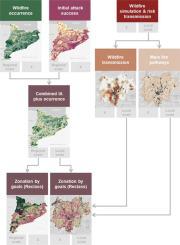
Despite the abundant firefighting resources deployed to reinforce the fire exclusion policy, extreme events continue to cause substantial losses in Mediterranean regions. These catastrophic wildfires question the merely-reactive response, while science-based decision-making advocates for a paradigm shift towards a long-term solution to coexist with fire. Comprehensive management solutions integrate multiple efforts to minimize the number of escaped wildfires in fire ignition hotspots, restrict large fire spread across the landscape, and prevent losses to valued resources and assets. This study develops a wildfire management zone (WMZ) delineation framework to inform decision-making in fire-prone Mediterranean landscapes. First, we combined modeling outcomes of wildfire occurrence, initial attack success, and wildfire transmission to communities to segment the landscape in WMZ blocks. We assumed the worst-case scenario in terms of fire simultaneity and weather conditions to implement the models. The geospatial outcomes were assembled and classified into four primary archetypes, and we then designated the most suitable risk mitigation strategies for each management unit. The WMZs included (1) comprehensive management, (2) human ignition prevention, (3) intensive fuel management, and (4) fire reintroduction areas. Finally, we downscaled within zones to assign specific management prescriptions to the different areas. The results were presented in a set of cross-scale maps to assist in designing risk management plans and raise social awareness. The methodological framework developed in this study may be valuable to help mitigate risk in fire-prone Mediterranean areas, but also in other regions in which similar total suppression policies fail to reduce catastrophic wildfire losses.
中文翻译:
整合地理空间野火模型以划定景观管理区并为地中海地区的决策提供信息
尽管部署了丰富的消防资源以加强防火政策,但极端事件继续在地中海地区造成重大损失。这些灾难性的野火质疑单纯的反应性反应,而基于科学的决策倡导范式转变为与火灾共存的长期解决方案。综合管理解决方案整合了多种努力,以最大限度地减少火灾热点中逃逸的野火数量,限制大火在整个景观中的蔓延,并防止对宝贵资源和资产造成损失。本研究开发了一个野火管理区 (WMZ) 划分框架,为易发生火灾的地中海景观的决策提供信息。首先,我们结合了野火发生、初始攻击成功、并将野火传播到社区以分割 WMZ 区块中的景观。我们在火灾同时性和天气条件方面假设了最坏的情况来实施模型。地理空间结果被汇总并分为四个主要原型,然后我们为每个管理单位指定了最合适的风险缓解策略。WMZ 包括 (1) 综合管理,(2) 人为点火预防,(3) 燃料强化管理,以及 (4) 火灾重新引入区。最后,我们在区域内缩小规模,为不同的区域分配特定的管理方案。结果以一组跨比例尺的地图形式呈现,以帮助设计风险管理计划并提高社会意识。


 京公网安备 11010802027423号