Weather and Climate Extremes ( IF 8 ) Pub Date : 2021-11-18 , DOI: 10.1016/j.wace.2021.100399 Dibesh Khadka 1 , Mukand S. Babel 1 , Sangam Shrestha 1 , Salvatore G.P. Virdis 2 , Matthew Collins 3
|
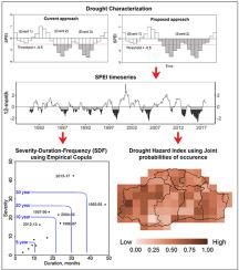
This study evaluates drought characteristics in the Mun River Basin, located in the northeast of Thailand. The basin is important from an agriculture perspective, as about 75% of the total area is under cultivation (a majority of which is without irrigation facilities). It is, however, also one of the most drought-prone regions in the country, and a proper understanding of drought characteristics can aid in planning and implementing drought mitigation and management strategies and measures in the basin. Using the Standardized Precipitation Evapotranspiration Index (SPEI), calculated from high-resolution climatic data during 1979–2017, we find that major drought events recur approximately every 6 years in the basin. A new approach to the use of thresholds to remove the effects of minor droughts is introduced. It is found to have improved drought characterization for prolonged drought events with low intensity. Drought events are evaluated for severity, duration, and frequency (SDF) using univariate and multivariate approaches at nine timescales (1-week to 24-months). Generalized Extreme Value (GEV) and Log-logistic (LL) are the most suitable distributions for SPEI calculation in the study area, though all three-parameter distributions have good fit at longer timescales. SPEI calculated at weekly timescales, especially during the vegetative stage of crop growth, show a good correlation with yields; thus, they can be useful for planning agricultural activities. Drought vulnerable assessment using joint occurrence probabilities of drought duration and severity indicates that most of the area in the western part and some area in the eastern part are the highest drought-prone regions in the basin. It is interesting to note that the drought prone areas of the basin are independent of the annual rainfall amount but are influenced by its temporal variability.
中文翻译:
泰国东北部气象干旱多变量多时相分析
本研究评估了位于泰国东北部的 Mun 河流域的干旱特征。从农业的角度来看,该流域很重要,因为总面积的 75% 左右在耕种(其中大部分没有灌溉设施)。然而,它也是该国最易发生干旱的地区之一,正确了解干旱特征有助于规划和实施该流域的干旱缓解和管理战略和措施。使用根据 1979-2017 年高分辨率气候数据计算的标准化降水蒸散指数 (SPEI),我们发现该流域大约每 6 年发生一次重大干旱事件。介绍了一种使用阈值来消除轻微干旱影响的新方法。人们发现,对于低强度的长期干旱事件,它具有改进的干旱特征。使用单变量和多变量方法在九个时间尺度(1 周至 24 个月)评估干旱事件的严重程度、持续时间和频率 (SDF)。广义极值 (GEV) 和 Log-logistic (LL) 是研究区域中最适合 SPEI 计算的分布,尽管所有三参数分布在更长的时间尺度上都具有良好的拟合。以每周时间尺度计算的 SPEI,尤其是在作物生长的营养阶段,显示出与产量的良好相关性;因此,它们可用于规划农业活动。干旱持续时间和严重程度联合发生概率的干旱脆弱性评估表明,西部大部分地区和东部部分地区是流域内干旱易发区最高的地区。值得注意的是,该流域的干旱易发地区与年降雨量无关,但受其时间变化的影响。


 京公网安备 11010802027423号