Agricultural Water Management ( IF 6.7 ) Pub Date : 2021-11-10 , DOI: 10.1016/j.agwat.2021.107298 Minghan Cheng 1, 2 , Binbin Li 3 , Xiyun Jiao 1 , Xiao Huang 4 , Haiyan Fan 2 , Rencai Lin 5 , Kaihua Liu 1
|
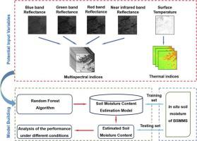
An accurate regional estimate of soil moisture content (SMC) is important for water management and drought monitoring. Traditional ground measurement methods of SMC are limited by the disadvantages of high cost and small scale. The development of remote sensing (RS) technology provides a cost-effective tool for estimating SMC at regional scale. However, the estimation of SMC by using the combination of multiple sensors has yet to be thoroughly discussed. Furthermore, the way in which vegetation types, fraction of vegetation coverage (FVC) and soil layer depth affect the SMC-estimation performance remains unclear. Therefore, the objectives in this study are to (1) evaluate the SMC-estimation performance provided by Landsat-8 data and random forest regression (RFR) algorithm; (2) discuss the accuracy of RS-based method for SMC estimation at different soil layer depths, and (3) explore how vegetation types and FVC affect the performance of SMC-estimation. The results can be summarized as: (1) the SMC estimation performance of multispectral (MS)- and thermal infrared (TIR)-based indices single used were comparable, in which TIR-based indices performed better in shallow soil layer while MS-based indices performed better in deep soil layer. Generally, MS- and TIR-based indices jointly used outperformed the index single used. (2) the accuracy of the proposed method for estimating SMC decreased with soil depth. (3) the proposed method performed greatest in grassland with relatively low height among the three vegetation types. Moreover, the SMC estimation in moderate vegetation coverage (FVC ranged from 0.3 to 0.5) was best. These results indicate that RS-based multimodal data combined with RFR could provide relatively repeatable and accurate SMC estimation. This approach can thus be used for the regional SMC monitoring and water resources management.


 京公网安备 11010802027423号