当前位置:
X-MOL 学术
›
Basin Res.
›
论文详情
Our official English website, www.x-mol.net, welcomes your feedback! (Note: you will need to create a separate account there.)
Deciphering Late Cretaceous palaeo-river catchments in eastern Australia: Recognition of distinct northern and southern drainage basins
Basin Research ( IF 3.2 ) Pub Date : 2021-11-05 , DOI: 10.1111/bre.12632 Elliot K. Foley 1 , Eric M. Roberts 1 , Espen M. Knutsen 1, 2
Basin Research ( IF 3.2 ) Pub Date : 2021-11-05 , DOI: 10.1111/bre.12632 Elliot K. Foley 1 , Eric M. Roberts 1 , Espen M. Knutsen 1, 2
Affiliation
|
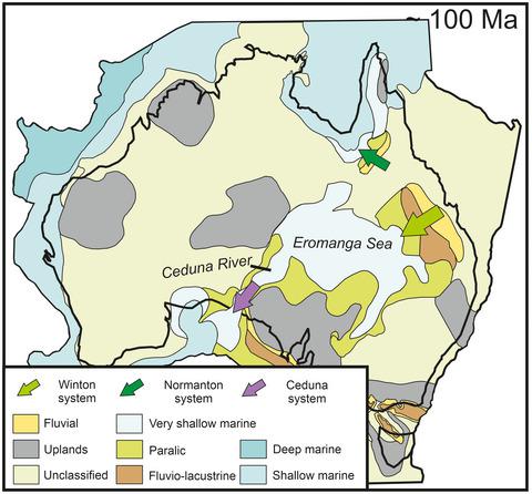
During the Early Cretaceous, Australia was flooded by the epicontinental Eromanga Sea, deposits of which occur across the Great Australian Superbasin. However, the mid-Cretaceous retreat of this shallow sea, and the resultant palaeogeographic and sediment distribution patterns, are poorly understood. This study chronicles the Eromanga Sea's northward regression through the Carpentaria Basin as captured in the sedimentary record of the Normanton Formation. We achieve this by integrating sedimentary facies analysis of cores from across the Carpentaria Basin with palynology, sandstone petrography and U-Pb detrital zircon geochronology. Results indicate that the Normanton Formation was deposited between ca. 100 and 96 Ma, and that it represents a large, northward-prograding, likely river-dominated delta system. The unit's volcanoclastic nature is exhibited through abundant lithic volcanics and devitrified glass, with a prominent, near-depositional detrital zircon population attributed to a proximal continental magmatic arc-derived source hypothesised to parallel the eastern seaboard of Australia at this time. The Normanton Formation is temporally correlative with the lower-middle portions of the similarly volcanoclastic Winton Formation in the Eromanga Basin, which drained southwards into the Cenomanian-Santonian Ceduna River Delta system. However, Normanton Formation strata display subtly different provenance signatures and drainage patterns, indicating input from similar, but likely more northern source terrains than much of the contemporaneous Winton Formation. These sediments were unlikely recycled southwards into the Ceduna Delta like those of the Winton Formation; rather they drained northward following the retreat of the Eromanga Sea through the Carpentaria Basin, indicating a Cretaceous drainage divide between two river systems, with distinct northern and southern drainage catchments. The mid-Cretaceous palaeogeography of eastern Australia is analogous to that of the Late Cretaceous Western Interior Seaway of North America, in which the retreat of a shallow epicontinental sea is marked by the rapid deposition and progradation of multiple large, geographically distinct clastic wedges.
中文翻译:

破译澳大利亚东部白垩纪晚期古河流域:识别不同的北部和南部流域盆地
在早白垩世,澳大利亚被大陆埃罗曼加海淹没,其沉积物遍布大澳大利亚超级盆地。然而,人们对这一浅海的白垩纪中期后退以及由此产生的古地理和沉积物分布模式知之甚少。这项研究记录了诺曼顿组沉积记录中所捕获的埃罗曼加海向北通过 Carpentaria 盆地的回归。我们通过将整个 Carpentaria 盆地岩心的沉积相分析与孢粉学、砂岩岩相学和 U-Pb 碎屑锆石年代学相结合来实现这一目标。结果表明,诺曼顿组沉积在 ca 之间。100 和 96 Ma,它代表了一个大型的、向北推进的、可能以河流为主的三角洲系统。那个单位' 火山碎屑的性质通过丰富的岩屑火山岩和玻璃化玻璃表现出来,具有突出的近沉积碎屑锆石种群归因于近端大陆岩浆弧衍生的来源,假设此时与澳大利亚东海岸平行。Normanton 组与 Eromanga 盆地类似火山碎屑 Winton 组的中下部在时间上相关,后者向南流入 Cenomanian-Santonian Ceduna River Delta 系统。然而,诺曼顿组地层显示出略微不同的物源特征和排水模式,表明输入来自类似但可能比同时代的温顿组更多的北部源地形。这些沉积物不太可能像 Winton 组那样向南再循环到塞杜纳三角洲。相反,它们在埃罗曼加海通过卡彭塔里亚盆地撤退后向北排干,表明两个河流系统之间存在白垩纪排水分水岭,具有明显的北部和南部排水集水区。澳大利亚东部白垩纪中期的古地理类似于北美晚白垩世西部内陆航道,其中陆缘浅海的后退以多个大型、地理上不同的碎屑楔的快速沉积和推进为标志。具有明显的南北排水集水区。澳大利亚东部白垩纪中期的古地理类似于北美晚白垩世西部内陆航道,其中陆缘浅海的后退以多个大型、地理上不同的碎屑楔的快速沉积和推进为标志。具有明显的南北排水集水区。澳大利亚东部白垩纪中期的古地理类似于北美晚白垩世西部内陆航道,其中陆缘浅海的后退以多个大型、地理上不同的碎屑楔的快速沉积和推进为标志。
更新日期:2021-11-05
中文翻译:
破译澳大利亚东部白垩纪晚期古河流域:识别不同的北部和南部流域盆地
在早白垩世,澳大利亚被大陆埃罗曼加海淹没,其沉积物遍布大澳大利亚超级盆地。然而,人们对这一浅海的白垩纪中期后退以及由此产生的古地理和沉积物分布模式知之甚少。这项研究记录了诺曼顿组沉积记录中所捕获的埃罗曼加海向北通过 Carpentaria 盆地的回归。我们通过将整个 Carpentaria 盆地岩心的沉积相分析与孢粉学、砂岩岩相学和 U-Pb 碎屑锆石年代学相结合来实现这一目标。结果表明,诺曼顿组沉积在 ca 之间。100 和 96 Ma,它代表了一个大型的、向北推进的、可能以河流为主的三角洲系统。那个单位' 火山碎屑的性质通过丰富的岩屑火山岩和玻璃化玻璃表现出来,具有突出的近沉积碎屑锆石种群归因于近端大陆岩浆弧衍生的来源,假设此时与澳大利亚东海岸平行。Normanton 组与 Eromanga 盆地类似火山碎屑 Winton 组的中下部在时间上相关,后者向南流入 Cenomanian-Santonian Ceduna River Delta 系统。然而,诺曼顿组地层显示出略微不同的物源特征和排水模式,表明输入来自类似但可能比同时代的温顿组更多的北部源地形。这些沉积物不太可能像 Winton 组那样向南再循环到塞杜纳三角洲。相反,它们在埃罗曼加海通过卡彭塔里亚盆地撤退后向北排干,表明两个河流系统之间存在白垩纪排水分水岭,具有明显的北部和南部排水集水区。澳大利亚东部白垩纪中期的古地理类似于北美晚白垩世西部内陆航道,其中陆缘浅海的后退以多个大型、地理上不同的碎屑楔的快速沉积和推进为标志。具有明显的南北排水集水区。澳大利亚东部白垩纪中期的古地理类似于北美晚白垩世西部内陆航道,其中陆缘浅海的后退以多个大型、地理上不同的碎屑楔的快速沉积和推进为标志。具有明显的南北排水集水区。澳大利亚东部白垩纪中期的古地理类似于北美晚白垩世西部内陆航道,其中陆缘浅海的后退以多个大型、地理上不同的碎屑楔的快速沉积和推进为标志。


 京公网安备 11010802027423号