Remote Sensing of Environment ( IF 13.5 ) Pub Date : 2021-10-12 , DOI: 10.1016/j.rse.2021.112734 Robbi Bishop-Taylor 1 , Rachel Nanson 1 , Stephen Sagar 1 , Leo Lymburner 1
|
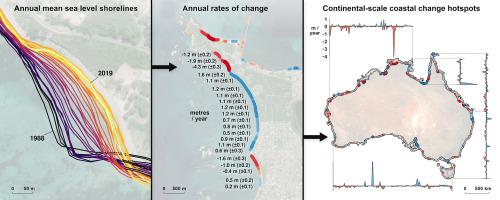
Accurate, robust and consistent coastline mapping is critical for characterising and managing coastal change. Satellite earth observation provides an unparalleled source of freely available data for studying dynamic coastlines through time and across large spatial extents. However, previous satellite-derived shoreline mapping approaches have been challenged by two key limitations: the medium spatial resolution of freely available satellite data, and the confounding influence of tides that can obscure longer term patterns of coastal change. In this study we present Digital Earth Australia Coastlines, a new continental dataset documenting three decades of coastal change across Australia. We combine sub-pixel waterline extraction with a new pixel-based tidal modelling method to seamlessly map almost 2 million km of tide-datum shorelines along the entire Australian coast from 1988 to 2019. Our tidally-constrained median composite approach maps the dominant annual position of the shoreline at 0 m Above Mean Sea Level each year, suppressing the short-term influence of tides and sub-annual shoreline variability. Using this robust mid-term shoreline proxy, long-term coastal change rates spanning the last three decades were accurately quantified and mapped at the continental scale. We find that 22% of Australia's non-rocky coastline has retreated or grown significantly since 1988, with 16% changing at greater than 0.5 m per year. Although trends of retreat and growth were closely balanced across the Australian continent, our results highlight significant regional variability and extreme local hotspots of coastal change. Our findings provide new insights into patterns and trends of coastal change across Australia, and highlight advantages and limitations of tide modelling and composite-based methods for extracting consistent shoreline data and long-term coastal trends from earth observation data at continental scale. Digital Earth Australia Coastlines is made available to the public as free and open interactive tools and code to support future coastal research and management across Australia, and any coastal region globally with access to free and open medium resolution satellite data.
中文翻译:
使用三个十年的 Landsat 图像绘制澳大利亚平均海平面的动态海岸线
准确、稳健和一致的海岸线测绘对于描述和管理海岸变化至关重要。卫星地球观测提供了无与伦比的免费数据来源,可用于研究跨时间跨大空间范围的动态海岸线。然而,以前的卫星衍生的海岸线测绘方法受到两个关键限制的挑战:免费可用卫星数据的中等空间分辨率,以及潮汐的混杂影响,可能会掩盖沿海变化的长期模式。在这项研究中,我们展示了数字地球澳大利亚海岸线,这是一个新的大陆数据集,记录了澳大利亚三个十年的海岸变化。我们将亚像素水线提取与一种新的基于像素的潮汐建模方法相结合,无缝地绘制了 1988 年至 2019 年整个澳大利亚海岸近 200 万公里的潮汐基准海岸线。我们的潮汐约束中值复合方法绘制了占主导地位的年度位置每年平均海平面以上 0 m 的海岸线,抑制了潮汐和次年海岸线变化的短期影响。使用这个强大的中期海岸线代理,跨越过去三年的长期海岸变化率被准确量化并在大陆尺度上绘制。我们发现,自 1988 年以来,澳大利亚 22% 的非岩石海岸线已经后退或显着增长,其中 16% 的变化每年超过 0.5 m。尽管整个澳大利亚大陆的退步和增长趋势密切平衡,我们的结果突出了显着的区域变异性和沿海变化的极端局部热点。我们的研究结果提供了对澳大利亚沿海变化模式和趋势的新见解,并强调了潮汐建模和基于复合方法的优势和局限性,用于从大陆尺度的地球观测数据中提取一致的海岸线数据和长期沿海趋势。数字地球澳大利亚海岸线作为免费和开放的交互式工具和代码向公众提供,以支持澳大利亚未来的海岸研究和管理,以及全球任何沿海地区可以访问免费和开放的中等分辨率卫星数据。并强调潮汐建模和基于复合方法的优点和局限性,用于从大陆尺度的地球观测数据中提取一致的海岸线数据和长期海岸趋势。数字地球澳大利亚海岸线作为免费和开放的交互式工具和代码向公众提供,以支持澳大利亚未来的海岸研究和管理,以及全球任何沿海地区可以访问免费和开放的中等分辨率卫星数据。并强调潮汐建模和基于复合方法的优点和局限性,用于从大陆尺度的地球观测数据中提取一致的海岸线数据和长期海岸趋势。数字地球澳大利亚海岸线作为免费和开放的交互式工具和代码向公众提供,以支持澳大利亚未来的海岸研究和管理,以及全球任何沿海地区可以访问免费和开放的中等分辨率卫星数据。


 京公网安备 11010802027423号