International Journal of Applied Earth Observation and Geoinformation ( IF 7.5 ) Pub Date : 2021-09-22 , DOI: 10.1016/j.jag.2021.102547 Moritz K Lehmann 1, 2 , Eike M Schütt 3 , Martin Hieronymi 3 , James Dare 4 , Hajo Krasemann 3
|
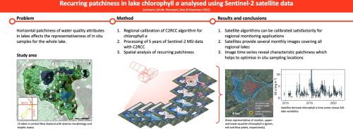
Horizontal patchiness of water quality attributes in lakes substantially influences the ability to accurately determine an average condition of a lake from traditional in situ sampling. Therefore, spatial variability has to be accounted for in monitoring programmes which aim at determining the states and trends of ecosystem attributes. We used five years of Sentinel-2 Multispectral Instrument (MSI) data and conducted spatial analyses of surface chlorophyll a (Chl) concentration to map its variability and provide concrete recommendations for resource managers to design in situ sampling programmes. First, we developed a regional calibration of Chl predictions by C2RCC, an openly available processor for atmospheric corrections and water constituent retrieval, using in situ data from eleven temperate lakes in the central North Island of Aotearoa New Zealand. Using 93 match-up samples, we re-fitted C2RCC’s partitioning of constituent absorption coefficients to achieve an improved prediction accuracy for Chl (r2 = 0.79, root mean square error = 5.4 mg m−3). The new relationship was applied to all cloud-free images for thirteen regional lakes for further spatial analysis. We found that the medians calculated within areas of different sizes around in situ sampling locations may increase or decrease, illustrating an unpredictable uncertainty of the representativeness of any in situ sample. We went on to summarise five years of spatial variability by assessing each pixel for its tendency to be near the lake median Chl, higher (near the upper quartile) or lower (near the lower quartile). This spatiotemporal analysis revealed recurring patchiness that we converted to an indication of the representativeness of any location in the lake useful for the selection of more representative sites for future monitoring programmes.
中文翻译:
分析卫星衍生叶绿素 a 中反复出现的斑块,以帮助选择代表性地点进行湖泊水质监测
湖泊水质属性的水平不均匀性极大地影响了通过传统原位采样准确确定湖泊平均状况的能力。因此,在旨在确定生态系统属性状态和趋势的监测计划中必须考虑空间变异性。我们使用了五年的 Sentinel-2 多光谱仪器 (MSI) 数据,并对表面叶绿素a ( Chl ) 浓度进行了空间分析,以绘制其变异性,并为资源管理者设计原位采样计划提供具体建议。首先,我们开发了Chl的区域校准C2RCC 是一个公开可用的大气校正和水成分检索处理器,使用来自新西兰北岛中部 11 个温带湖泊的原位数据进行预测。使用 93 个匹配样本,我们重新拟合了 C2RCC 对成分吸收系数的划分,以提高Chl 的预测精度(r 2 = 0.79,均方根误差 = 5.4 mg m -3)。新关系应用于 13 个区域湖泊的所有无云图像,以进行进一步的空间分析。我们发现,在原位采样位置周围不同大小的区域内计算的中位数可能会增加或减少,说明任何原位样本的代表性都存在不可预测的不确定性。我们通过评估每个像素接近湖泊中位数Chl、更高(接近上四分位数)或更低(接近下四分位数)的趋势,继续总结了五年的空间变异性。这种时空分析揭示了反复出现的不均匀性,我们将其转换为湖泊中任何位置的代表性指示,这有助于为未来的监测计划选择更具代表性的地点。


 京公网安备 11010802027423号