当前位置:
X-MOL 学术
›
Basin Res.
›
论文详情
Our official English website, www.x-mol.net, welcomes your feedback! (Note: you will need to create a separate account there.)
Mud volcanoes and dissolution structures as kinematic markers during salt tectonic deformation
Basin Research ( IF 3.2 ) Pub Date : 2021-09-06 , DOI: 10.1111/bre.12612 Chris Kirkham 1 , Joe Cartwright 1
Basin Research ( IF 3.2 ) Pub Date : 2021-09-06 , DOI: 10.1111/bre.12612 Chris Kirkham 1 , Joe Cartwright 1
Affiliation
|
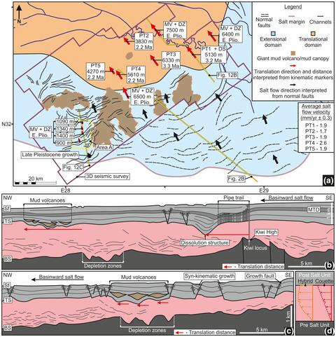
The recognition of linear trails of fluid escape pipes that have been deformed by salt flow have recently been suggested to offer a novel approach to reconstructing the internal kinematics of thick salt sequences deforming under gravity. These deformed pipes constrain a number of key parameters for salt tectonic analysis including the salt flow direction, translation distance of the top salt and overburden, the internal flow profile and from the flow velocity, the bulk viscosity of the salt. Here we interpret and characterise two previously unrecognised large-scale strain markers within a salt sequence that may be equally as valuable as the deformed pipes for constraining salt flow. This study is based on the interpretation of a ca. 4,600 km2 3D seismic survey from the outer slope of the Nile Cone, offshore Egypt, located at the boundary between the extensional and translational domains of the deformed marginal region of the Messinian salt basin. We mapped five deformed pipe trails that allow us to constrain the average flow velocity of the top salt, at ca. 2 mm/yr over the past 2–3 Myrs. The salt flowed in a basinward NW/NNW direction away from the basin margin. In addition, we mapped two large (ca. 2 km diameter) salt dissolution depressions formed by subjacent dissolution of the evaporites. These are presently located down the salt flow direction of a large remnant erosional high at the base of the salt, and in the general alignment of one of the pipe trails. We therefore argue that this dissolution structure most likely formed by fluid venting from the base salt high, and as such can be used to measure translation direction, distance and average velocity. The second of the two novel kinematic indicators requires mapping of genetically connected mud volcanoes and their depletion zones. The study area contains over 400 individual mud volcanoes that are sourced from beneath the salt and erupted from the Early Pliocene to Recent. A subset of these, extruded at or near to the present day seafloor, have well imaged pre-salt depletion zones vertically beneath the erupted volcanic cones. A smaller subset, typically buried Early Pliocene extrusions, is found to have volcanic cones that are systematically offset laterally from their corresponding depletion zones, with an offset direction and distances closely matched with other kinematic markers. Hence we suggest that mud volcanic plumbing systems can provide another independent kinematic marker from which to infer salt flow regime.
中文翻译:

泥火山和溶解结构作为盐构造变形过程中的运动学标志
最近有人建议识别已被盐流变形的流体逸出管的线性轨迹,以提供一种新的方法来重建在重力作用下变形的厚盐序列的内部运动学。这些变形的管道限制了盐构造分析的许多关键参数,包括盐的流动方向、顶部盐和覆盖层的平移距离、内部流动剖面以及流速、盐的体积粘度。在这里,我们解释和表征盐序列中两个以前未被识别的大规模应变标记,它们可能与用于约束盐流的变形管道同样有价值。这项研究是基于对 ca 的解释。4,600 公里2来自埃及近海尼罗锥外坡的 3D 地震勘测,位于麦西尼盐盆地变形边缘区域的伸展域和平移域之间的边界。我们绘制了五个变形的管道轨迹,使我们能够限制顶部盐的平均流速,大约在 10 小时。过去 2-3 Myrs 2 毫米/年。盐从盆地边缘向盆地 NW/NNW 方向流动。此外,我们绘制了两个由蒸发岩下方溶解形成的大型(直径约 2 公里)盐溶洼地。这些目前位于盐基底部的大型残余侵蚀高地的盐流方向下方,并且位于其中一条管道路径的总体对齐中。因此,我们认为这种溶解结构很可能是由基盐高处的流体排出形成的,因此可用于测量平移方向、距离和平均速度。两个新的运动学指标中的第二个需要绘制与遗传相关的泥火山及其消耗区的地图。研究区包含 400 多座单独的泥火山,这些泥火山来自盐下,从上新世早期到近期喷发。其中一部分在现今海底或附近被挤压,在喷发的火山锥下方具有良好成像的盐前耗竭区。一个较小的子集,通常是埋藏的早上新世挤压物,被发现有火山锥,这些火山锥从相应的枯竭区横向偏移,偏移方向和距离与其他运动学标记密切匹配。
更新日期:2021-09-06
中文翻译:
泥火山和溶解结构作为盐构造变形过程中的运动学标志
最近有人建议识别已被盐流变形的流体逸出管的线性轨迹,以提供一种新的方法来重建在重力作用下变形的厚盐序列的内部运动学。这些变形的管道限制了盐构造分析的许多关键参数,包括盐的流动方向、顶部盐和覆盖层的平移距离、内部流动剖面以及流速、盐的体积粘度。在这里,我们解释和表征盐序列中两个以前未被识别的大规模应变标记,它们可能与用于约束盐流的变形管道同样有价值。这项研究是基于对 ca 的解释。4,600 公里2来自埃及近海尼罗锥外坡的 3D 地震勘测,位于麦西尼盐盆地变形边缘区域的伸展域和平移域之间的边界。我们绘制了五个变形的管道轨迹,使我们能够限制顶部盐的平均流速,大约在 10 小时。过去 2-3 Myrs 2 毫米/年。盐从盆地边缘向盆地 NW/NNW 方向流动。此外,我们绘制了两个由蒸发岩下方溶解形成的大型(直径约 2 公里)盐溶洼地。这些目前位于盐基底部的大型残余侵蚀高地的盐流方向下方,并且位于其中一条管道路径的总体对齐中。因此,我们认为这种溶解结构很可能是由基盐高处的流体排出形成的,因此可用于测量平移方向、距离和平均速度。两个新的运动学指标中的第二个需要绘制与遗传相关的泥火山及其消耗区的地图。研究区包含 400 多座单独的泥火山,这些泥火山来自盐下,从上新世早期到近期喷发。其中一部分在现今海底或附近被挤压,在喷发的火山锥下方具有良好成像的盐前耗竭区。一个较小的子集,通常是埋藏的早上新世挤压物,被发现有火山锥,这些火山锥从相应的枯竭区横向偏移,偏移方向和距离与其他运动学标记密切匹配。


 京公网安备 11010802027423号