Atmospheric Research ( IF 5.5 ) Pub Date : 2021-08-24 , DOI: 10.1016/j.atmosres.2021.105820 Otávio Nunes dos Santos 1 , Leonardo Hoinaski 2
|
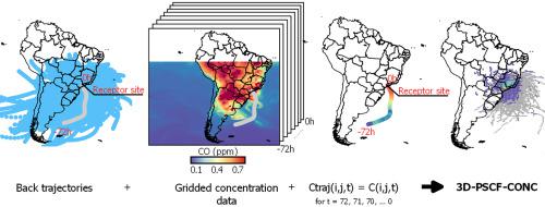
The identification of air pollution sources is a challenging task due to the confounding effects of local and transboundary emitters. While the Potential Source Contribution Function (PSCF) is a useful tool for trajectory analysis and source identification, it can overestimate the impact of less polluted areas in which a trajectory event passed through. In this work, we propose incorporating air pollutant concentration fields from reanalysis data to improve the PSCF method's performance that avoids the overcontribution of less polluted areas. We develop the 3D-PSCF-CONC based on an updated three-dimensional version of the PSCF method (3D-PSCF). We used as a test case the Metropolitan Area of São Paulo (MASP) in Brazil, one of the most polluted regions in the world, for comparing the results of the conventional and the new PSCF method. A monitoring station in Vitória - Espírito Santo, Brazil which has smaller local emissions than MASP is used as an auxiliary test case. Hourly carbon monoxide (CO) and sulfur dioxide (SO2) concentrations from 2015 to 2019 of monitoring stations were analyzed. The daily average concentrations of CO and SO2 were used as a threshold on the probability calculations. An overall of 1825 backward trajectories from HYSPLIT version 4 was processed using the three models. CO and SO2 surface concentrations from MERRA-2, with a resolution of 0.5° x 0.625° was incorporated in the 3D-PSCF-CONC to correct the potential contribution calculation based on the air pollutant concentration field. Our results revealed that the 3D-PSCF-CONC reached a more consistent identification of local and regional sources, rather than emphasizing mostly the regional sources as the other PSCF methods. The 3D-PSCF-CONC reduced the potential contribution of less polluted and high precipitation areas. The analysis suggests a contribution of vehicular sources close to the receptor site in MASP and long-range transport of industrial emissions and biomass burning from the land clearing of sugarcane production. This work presents an important tool for understanding the air pollution process and source identification.
中文翻译:
在空气污染回溯轨迹分析中结合网格化浓度数据进行源识别
由于本地和跨界排放源的混杂影响,确定空气污染源是一项具有挑战性的任务。虽然潜在源贡献函数 (PSCF) 是用于轨迹分析和源识别的有用工具,但它可以高估轨迹事件经过的污染较轻区域的影响。在这项工作中,我们建议结合再分析数据中的空气污染物浓度场,以提高 PSCF 方法的性能,避免污染较轻区域的过度贡献。我们基于 PSCF 方法 (3D-PSCF) 的更新的三维版本开发了 3D-PSCF-CONC。我们使用巴西圣保罗大都会区 (MASP) 作为测试案例,巴西是世界上污染最严重的地区之一,用于比较传统和新 PSCF 方法的结果。巴西圣埃斯皮里图 (Espírito Santo) 的 Vitória 监测站被用作辅助测试案例,该监测站的本地排放量比 MASP 小。每小时一氧化碳 (CO) 和二氧化硫 (SO)2 ) 分析了2015-2019年监测站的浓度。CO 和 SO 2的日平均浓度用作概率计算的阈值。使用这三个模型处理了来自 HYSPLIT 第 4 版的总共 1825 条后向轨迹。CO和SO 2来自 MERRA-2 的表面浓度,分辨率为 0.5° x 0.625° 被纳入 3D-PSCF-CONC 以校正基于空气污染物浓度场的潜在贡献计算。我们的结果表明,3D-PSCF-CONC 对本地和区域来源的识别更加一致,而不是像其他 PSCF 方法那样主要强调区域来源。3D-PSCF-CONC 减少了污染少和降水量高的地区的潜在贡献。分析表明,靠近 MASP 受体位点的车辆源以及甘蔗生产土地清理产生的工业排放和生物质燃烧的远程传输的贡献。这项工作为了解空气污染过程和来源识别提供了重要工具。


 京公网安备 11010802027423号