International Journal of Applied Earth Observation and Geoinformation ( IF 7.5 ) Pub Date : 2021-08-19 , DOI: 10.1016/j.jag.2021.102490 Abhishek Banerjee 1 , Ruishan Chen 1 , Michael E. Meadows 1, 2, 3, 4 , Dhritiraj Sengupta 1 , Shray Pathak 1 , Zilong Xia 1 , Suraj Mal 5
|
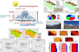
Research on the Himalayan cryosphere has increasingly focused on climate change, considering aspects such as snow cover dynamics, precipitation and temperature trends. The Uttarakhand Himalaya is hydrologically very significant and a more comprehensive understanding of its response to climate change is needed. This paper analyses of elevation-dependent distribution and trends in snow-covered area (SCA), precipitation and temperature for the period 2000–2020 employing MODIS-Terra data, together with reanalysis (CHIRPS) and Landsat-8 data products within the Google Earth Engine (GEE) platform. The study reveals a significant increasing trend in annual, seasonal and monthly precipitation (except November) at different elevations, while SCA and temperatures exhibited more variable trends during the period. Digital elevation and spectral reflectance models reveal the effects of topography and surface attributes on snow cover. Statistical analyses reveal a significant relationship between precipitation and SCA (R2 = 0.78), while seasonal changes in temperature are apparent in an emerging pattern of warmer winters and a cooler pre-monsoon. SCA trends vary markedly between elevation zones in response to precipitation and temperature fluctuations. At higher altitudes, SCA decreased from 2000 to 2020 since, although precipitation increased slightly, marginally higher temperatures led to more snowmelt. Reduced snow cover and increased temperature are also associated with a decline in downstream fluvial during the period for which such data are available (2000 to 2005). The analysis of snow cover dynamics across different elevations improves our understanding of the overall hydrological conditions in the region and enable more reliable flood forecasting and management of water resources.
中文翻译:
跟踪第三极的 21 世纪气候动态:使用 Google 地球引擎分析地形气候对喜马拉雅中部积雪的影响
对喜马拉雅冰冻圈的研究越来越关注气候变化,考虑到积雪动态、降水和温度趋势等方面。北阿坎德邦喜马拉雅山在水文方面非常重要,需要更全面地了解其对气候变化的反应。本文利用 MODIS-Terra 数据以及 Google Earth 中的再分析 (CHIRPS) 和 Landsat-8 数据产品分析了 2000-2020 年期间积雪覆盖区 (SCA)、降水和温度的高程相关分布和趋势引擎 (GEE) 平台。研究表明,不同海拔的年、季节和月降水量(11 月除外)均呈显着增加趋势,而同期 SCA 和气温则表现出更多的变化趋势。数字高程和光谱反射率模型揭示了地形和表面属性对积雪的影响。统计分析揭示了降水与 SCA 之间的显着关系(R2 = 0.78),而温度的季节性变化在较暖的冬季和较冷的季风前的新兴模式中很明显。响应降水和温度波动,不同海拔区域的 SCA 趋势显着不同。在高海拔地区,SCA 从 2000 年到 2020 年下降,因为尽管降水量略有增加,但略微升高的温度导致更多的融雪。在可获得此类数据的时期(2000 年至 2005 年),积雪减少和温度升高也与下游河流减少有关。对不同海拔高度积雪动态的分析提高了我们对该地区整体水文状况的了解,并实现了更可靠的洪水预报和水资源管理。


 京公网安备 11010802027423号