当前位置:
X-MOL 学术
›
Earth Surf.Process. Land.
›
论文详情
Our official English website, www.x-mol.net, welcomes your feedback! (Note: you will need to create a separate account there.)
Geomorphic covariance structure of a confined mountain river reveals landform organization stage threshold
Earth Surface Processes and Landforms ( IF 3.3 ) Pub Date : 2021-07-24 , DOI: 10.1002/esp.5195 Gregory B. Pasternack 1 , Joni Gore 1 , Jason Wiener 1
Earth Surface Processes and Landforms ( IF 3.3 ) Pub Date : 2021-07-24 , DOI: 10.1002/esp.5195 Gregory B. Pasternack 1 , Joni Gore 1 , Jason Wiener 1
Affiliation
|
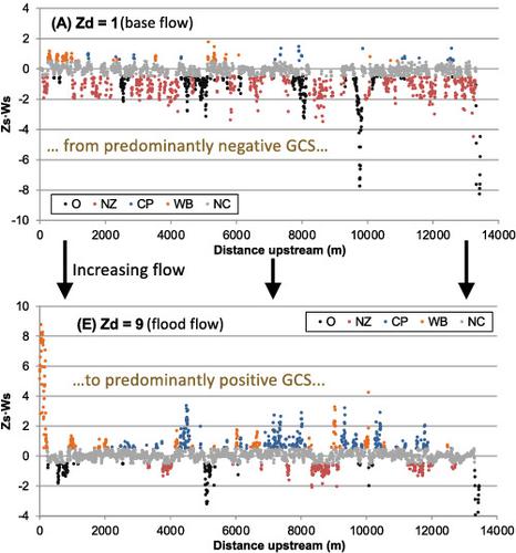
Significant growth in mountain rivers research since 1990 has promoted the concept that canyon-confined mountain rivers have complex topographic features nested from base- to flood-stages due to canyon structure and abundant large bed elements. Nesting means literally structures inside of structures. Mathematically, nesting means that multiple individual features and repeating patterns exist at different frequency, amplitude, and phasing, and can be added together to obtain the complete structure. Until now, subreach-scale landform structure, including nesting, has not been quantified sufficiently to understand morphodynamic mechanisms that control and respond to such organization. Geomorphic covariance structure analysis offers a systematic framework for evaluating nested topographic patterns. In this study, a threshold stage in mountain river inundation was hypothesized to exist. Above this stage landform structure is organized to be freely self-maintaining via flow convergence routing morphodynamics. A 13.2 km segment of the canyon-confined Yuba River, California, was studied using 2944 cross-sections. Geomorphic covariance structure analysis was carried out on a meter-resolution topographic model to test the hypothesis. River width and bed elevation had significantly less variability than previously reported for lower slope, partially confined gravel/cobble river reaches. A critical stage threshold governing flow convergence routing morphodynamics was evident in several metrics. Below this threshold, narrow/high “nozzle” and wide/low “oversized” were the dominant landforms (excluding “normal channel”), while above it wide/high “wide bar” and narrow/low “constricted pool” were dominant. Three-stage nesting of base-bankfull-flood landforms was dictated by canyon confinement, with nozzle–nozzle–nozzle nesting as the top permutation, excluding normal channel.
中文翻译:

承压山河地貌协方差结构揭示地貌组织阶段阈值
自 1990 年以来山地河流研究的显着增长促进了这样的概念,即由于峡谷结构和丰富的大河床元素,峡谷封闭的山地河流具有从基部到洪水阶段嵌套的复杂地形特征。嵌套的字面意思是结构内部的结构。在数学上,嵌套意味着多个单独的特征和重复模式以不同的频率、幅度和相位存在,并且可以加在一起以获得完整的结构。到目前为止,包括筑巢在内的子区域尺度地貌结构还没有被充分量化以了解控制和响应这种组织的形态动力学机制。地貌协方差结构分析为评估嵌套的地形模式提供了一个系统的框架。在这项研究中,假设存在山区河流泛滥的临界阶段。在这个阶段之上,地貌结构被组织成通过流会聚路由形态动力学自由地自我维护。使用 2944 个横截面研究了加利福尼亚州尤巴河的 13.2 公里段。对米分辨率地形模型进行地貌协方差结构分析以检验假设。河流宽度和河床高程的变异性比先前报告的较低坡度、部分封闭的砾石/鹅卵石河段的变异性要小得多。控制流收敛路由形态动力学的关键阶段阈值在几个指标中很明显。低于这个阈值,窄/高“喷嘴”和宽/低“超大”是优势地貌(不包括“正常通道”),而在其上方的宽/高“宽条”和窄/低“收缩池”占主导地位。底堤全洪水地貌三级嵌套受峡谷约束,以喷口-喷口-喷口嵌套为顶部排列,不包括正常渠道。
更新日期:2021-07-24
中文翻译:
承压山河地貌协方差结构揭示地貌组织阶段阈值
自 1990 年以来山地河流研究的显着增长促进了这样的概念,即由于峡谷结构和丰富的大河床元素,峡谷封闭的山地河流具有从基部到洪水阶段嵌套的复杂地形特征。嵌套的字面意思是结构内部的结构。在数学上,嵌套意味着多个单独的特征和重复模式以不同的频率、幅度和相位存在,并且可以加在一起以获得完整的结构。到目前为止,包括筑巢在内的子区域尺度地貌结构还没有被充分量化以了解控制和响应这种组织的形态动力学机制。地貌协方差结构分析为评估嵌套的地形模式提供了一个系统的框架。在这项研究中,假设存在山区河流泛滥的临界阶段。在这个阶段之上,地貌结构被组织成通过流会聚路由形态动力学自由地自我维护。使用 2944 个横截面研究了加利福尼亚州尤巴河的 13.2 公里段。对米分辨率地形模型进行地貌协方差结构分析以检验假设。河流宽度和河床高程的变异性比先前报告的较低坡度、部分封闭的砾石/鹅卵石河段的变异性要小得多。控制流收敛路由形态动力学的关键阶段阈值在几个指标中很明显。低于这个阈值,窄/高“喷嘴”和宽/低“超大”是优势地貌(不包括“正常通道”),而在其上方的宽/高“宽条”和窄/低“收缩池”占主导地位。底堤全洪水地貌三级嵌套受峡谷约束,以喷口-喷口-喷口嵌套为顶部排列,不包括正常渠道。


 京公网安备 11010802027423号