当前位置:
X-MOL 学术
›
Hydrol. Process.
›
论文详情
Our official English website, www.x-mol.net, welcomes your feedback! (Note: you will need to create a separate account there.)
Conceptualizing a multi-layered shingle aquifer model based on volcanic stratigraphy and water inflow to lava caves in Jeju Island, Korea
Hydrological Processes ( IF 3.2 ) Pub Date : 2021-07-21 , DOI: 10.1002/hyp.14316 Ung San Ahn 1 , Dong‐Chan Koh 2, 3 , Joonghyeok Heo 4 , Byong Wook Cho 2 , Taehee Kim 2 , Byoung‐Woo Yum 2
Hydrological Processes ( IF 3.2 ) Pub Date : 2021-07-21 , DOI: 10.1002/hyp.14316 Ung San Ahn 1 , Dong‐Chan Koh 2, 3 , Joonghyeok Heo 4 , Byong Wook Cho 2 , Taehee Kim 2 , Byoung‐Woo Yum 2
Affiliation
|
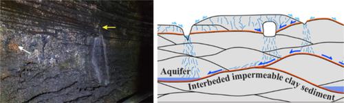
Volcanic aquifers supply a substantial portion of water resources in many parts of the world, including islands, and their productivity depends strongly on volcanic stratigraphy, which exhibits considerable heterogeneity. We investigated water inflow to lava tube caves formed from numerous basaltic lava flows in the northeastern coastal area of Jeju Island after storm events and monitored relative inflow rates monthly over 1 year to characterize groundwater flow processes in the upper parts of volcanic aquifers, and to evaluate the applicability of the previous hydrogeological models proposed for the island. Considerable water inflow arose shortly after storms from exposed palaeosol layers on the walls of the caves. The monthly monitoring results showed that wall inflow associated with these palaeosol layers is substantial. In both cases, discharge from ceiling drips was much less and more temporally variable compared to wall inflow discharge. Water flowing into the caves was rapidly drained through the floor at all monitoring sites. The lateral extent of the palaeosol layers was identified using drill core logs near the cave and outcrops in the coastal area. Based on these results, we inferred that multiple perched aquifers are formed by low-permeability palaeosol layers between lava flows, which are connected by vertical flows at discontinuities in the palaeosol layer, eventually reaching the basal aquifer. This study revealed the water inflow processes observed in lava tube caves constrained by palaeosol layers, and established a hydrogeological conceptual model incorporating multiple perched aquifers in both coastal and mountainous areas associated with extensive palaeosol layers formed during volcanic hiatuses. This finding would help elucidate recharge, groundwater flow, and contaminant transport processes in many volcanic aquifers that are not adequately represented by the previous models, and contribute to better management of groundwater in those areas.
中文翻译:

基于火山地层和流入韩国济州岛熔岩洞穴的水,概念化多层瓦状含水层模型
火山含水层为世界许多地区(包括岛屿)提供了很大一部分水资源,其生产力在很大程度上取决于火山地层,火山地层表现出相当大的异质性。我们调查了风暴事件后济州岛东北部沿海地区大量玄武岩熔岩流形成的熔岩管洞穴的水流入情况,并在 1 年内每月监测相对流入率,以表征火山含水层上部的地下水流过程,并评估先前为该岛提出的水文地质模型的适用性。风暴过后不久,洞穴壁上暴露的古土壤层就出现了大量的水流入。月度监测结果表明,与这些古土壤层相关的壁面流入量很大。在这两种情况下,与墙壁流入排放相比,天花板滴水的排放要少得多,而且在时间上的变化更大。流入洞穴的水通过所有监测点的地板迅速排出。古土壤层的横向范围是使用靠近洞穴和沿海地区露头的钻芯测井确定的。基于这些结果,我们推断熔岩流之间的低渗透性古土壤层形成了多个栖息含水层,它们在古土壤层中的不连续处通过垂直流连接,最终到达基底含水层。这项研究揭示了在受古土壤层约束的熔岩管洞穴中观察到的水流入过程,并建立了一个水文地质概念模型,其中包含与火山中断期间形成的广泛古土壤层相关的沿海和山区的多个栖息含水层。这一发现将有助于阐明先前模型未充分代表的许多火山含水层中的补给、地下水流动和污染物迁移过程,并有助于更好地管理这些地区的地下水。
更新日期:2021-08-10
中文翻译:
基于火山地层和流入韩国济州岛熔岩洞穴的水,概念化多层瓦状含水层模型
火山含水层为世界许多地区(包括岛屿)提供了很大一部分水资源,其生产力在很大程度上取决于火山地层,火山地层表现出相当大的异质性。我们调查了风暴事件后济州岛东北部沿海地区大量玄武岩熔岩流形成的熔岩管洞穴的水流入情况,并在 1 年内每月监测相对流入率,以表征火山含水层上部的地下水流过程,并评估先前为该岛提出的水文地质模型的适用性。风暴过后不久,洞穴壁上暴露的古土壤层就出现了大量的水流入。月度监测结果表明,与这些古土壤层相关的壁面流入量很大。在这两种情况下,与墙壁流入排放相比,天花板滴水的排放要少得多,而且在时间上的变化更大。流入洞穴的水通过所有监测点的地板迅速排出。古土壤层的横向范围是使用靠近洞穴和沿海地区露头的钻芯测井确定的。基于这些结果,我们推断熔岩流之间的低渗透性古土壤层形成了多个栖息含水层,它们在古土壤层中的不连续处通过垂直流连接,最终到达基底含水层。这项研究揭示了在受古土壤层约束的熔岩管洞穴中观察到的水流入过程,并建立了一个水文地质概念模型,其中包含与火山中断期间形成的广泛古土壤层相关的沿海和山区的多个栖息含水层。这一发现将有助于阐明先前模型未充分代表的许多火山含水层中的补给、地下水流动和污染物迁移过程,并有助于更好地管理这些地区的地下水。


 京公网安备 11010802027423号