当前位置:
X-MOL 学术
›
Geolog. J.
›
论文详情
Our official English website, www.x-mol.net, welcomes your feedback! (Note: you will need to create a separate account there.)
An integrated geotechnical and geophysical investigation of a catastrophic landslide in the Northeast Himalayas of Pakistan
Geological Journal ( IF 1.8 ) Pub Date : 2021-07-06 , DOI: 10.1002/gj.4209 Muhammad Asim Khan 1 , Muhammad Basharat 1 , Muhammad Tayyib Riaz 1, 2 , Yasir Sarfraz 1 , Muhammad Farooq 1 , Ali Yousaf Khan 1 , Quoc Bao Pham 3 , Khawaja Shoaib Ahmed 1 , Amir Shahzad 1, 2
Geological Journal ( IF 1.8 ) Pub Date : 2021-07-06 , DOI: 10.1002/gj.4209 Muhammad Asim Khan 1 , Muhammad Basharat 1 , Muhammad Tayyib Riaz 1, 2 , Yasir Sarfraz 1 , Muhammad Farooq 1 , Ali Yousaf Khan 1 , Quoc Bao Pham 3 , Khawaja Shoaib Ahmed 1 , Amir Shahzad 1, 2
Affiliation
|
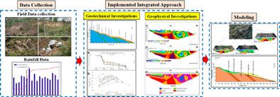
Landslides are a complex geohazard, and the key parameters that have a prominent effect on their nature are variations in slope angle and fluctuations in groundwater. The focus of this research was to analyse the prevailing conditions of the Danna-Sahotar landslide in the south of Muzaffarabad district, Sub-Himalayas, Pakistan, and evaluating how different conditions effect the stability of the landslide with the integration of geotechnical, geophysical, and slope stability analysis. The geotechnical investigations revealed that the surface layer is mainly sandy with clayey and silty content. The two-dimensional (2D) electrical resistivity tomography (ERT) demarcated the presence of a possible slip surface situated in the portion where the resistivity values clearly change. The ERT of the crown is characterized by low resistivity due to the presence of water seepages, which increase the degree of saturation and pore water pressure hence, leading to the slope failure. It was proved that the presence of high moisture content has played an influential role in triggering the landslide. Thorough analysis of integrated research yielded reliable and accurate information on the geotechnical and geological aspects of the landslide. The outcomes were used in slope stability limit equilibrium method (LEM) analysis using GeoStudio software. The slip surface predicted from the LEM was almost circular, which was confirmed by the geotechnical and ERT method. The factor of safety Fs (0.830) along the longitudinal profile of the landslide was calculated, indicating that the slopes along the profile are unstable. The geotechnical survey in combination with ERT and slope stability analysis helped to understand the failure mechanism of the landslide and to improve the layout of the future monitoring experiment, which may be used as a key for the observation of similar slope investigation.
中文翻译:

巴基斯坦东北部喜马拉雅山灾难性滑坡的综合岩土工程和地球物理调查
滑坡是一种复杂的地质灾害,对其性质有显着影响的关键参数是坡度的变化和地下水的波动。本研究的重点是分析巴基斯坦亚喜马拉雅山穆扎法拉巴德地区南部 Danna-Sahotar 滑坡的盛行条件,并结合岩土、地球物理和技术综合评估不同条件对滑坡稳定性的影响。边坡稳定性分析。岩土工程勘察表明,表层以砂质为主,含粘土和粉砂质。二维 (2D) 电阻率断层扫描 (ERT) 标定了位于电阻率值明显变化的部分中可能存在的滑动面。由于渗水的存在,冠部的ERT具有电阻率低的特点,从而增加饱和度和孔隙水压力,从而导致边坡破坏。事实证明,高含水量的存在对引发滑坡起到了重要作用。综合研究的彻底分析产生了关于滑坡的岩土工程和地质方面的可靠和准确的信息。结果用于使用 GeoStudio 软件的边坡稳定性极限平衡法 (LEM) 分析。从 LEM 预测的滑移面几乎是圆形的,这被岩土工程和 ERT 方法证实。计算了沿滑坡纵剖面的安全系数Fs(0.830),表明沿纵剖面的斜坡是不稳定的。
更新日期:2021-09-02
中文翻译:
巴基斯坦东北部喜马拉雅山灾难性滑坡的综合岩土工程和地球物理调查
滑坡是一种复杂的地质灾害,对其性质有显着影响的关键参数是坡度的变化和地下水的波动。本研究的重点是分析巴基斯坦亚喜马拉雅山穆扎法拉巴德地区南部 Danna-Sahotar 滑坡的盛行条件,并结合岩土、地球物理和技术综合评估不同条件对滑坡稳定性的影响。边坡稳定性分析。岩土工程勘察表明,表层以砂质为主,含粘土和粉砂质。二维 (2D) 电阻率断层扫描 (ERT) 标定了位于电阻率值明显变化的部分中可能存在的滑动面。由于渗水的存在,冠部的ERT具有电阻率低的特点,从而增加饱和度和孔隙水压力,从而导致边坡破坏。事实证明,高含水量的存在对引发滑坡起到了重要作用。综合研究的彻底分析产生了关于滑坡的岩土工程和地质方面的可靠和准确的信息。结果用于使用 GeoStudio 软件的边坡稳定性极限平衡法 (LEM) 分析。从 LEM 预测的滑移面几乎是圆形的,这被岩土工程和 ERT 方法证实。计算了沿滑坡纵剖面的安全系数Fs(0.830),表明沿纵剖面的斜坡是不稳定的。


 京公网安备 11010802027423号